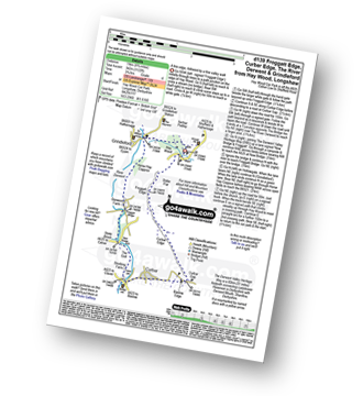
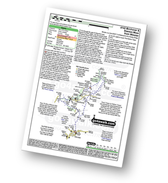
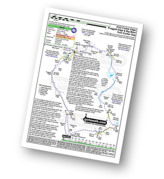
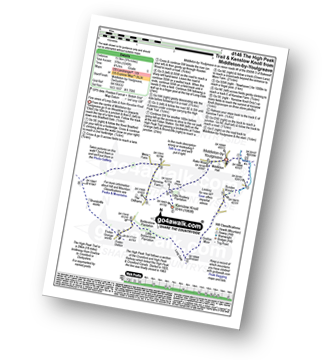
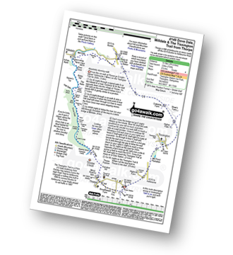
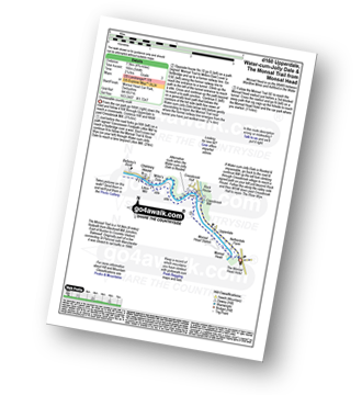
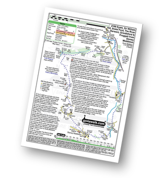
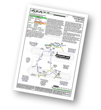
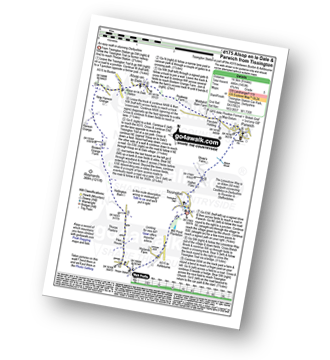
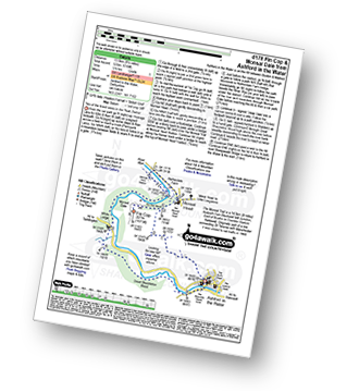
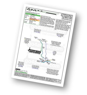
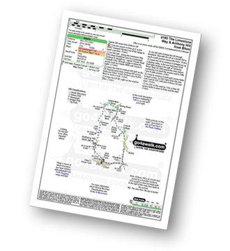
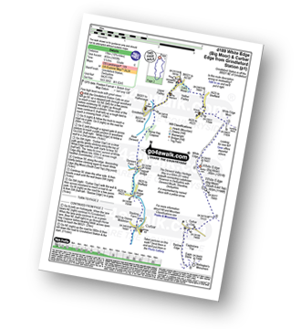
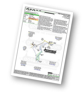
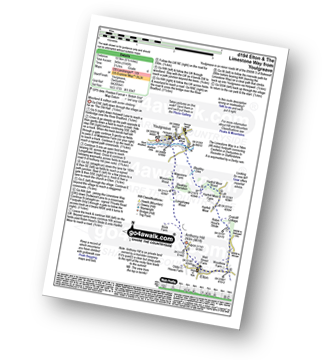
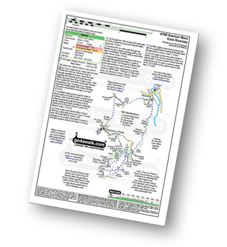
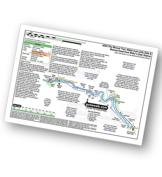
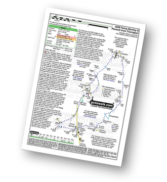
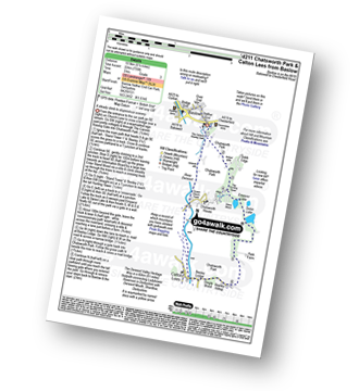
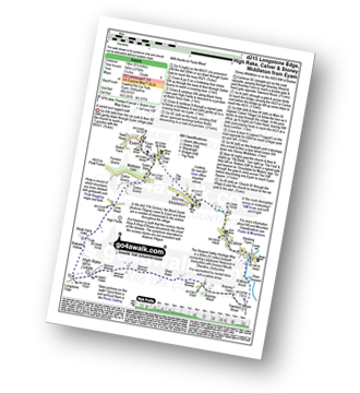
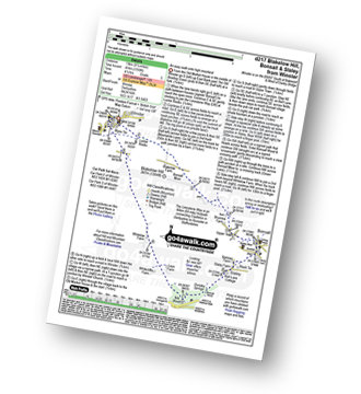
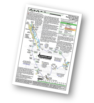
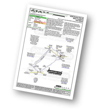
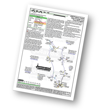
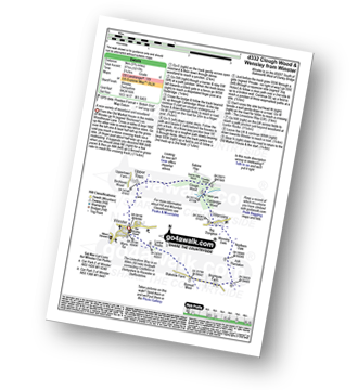
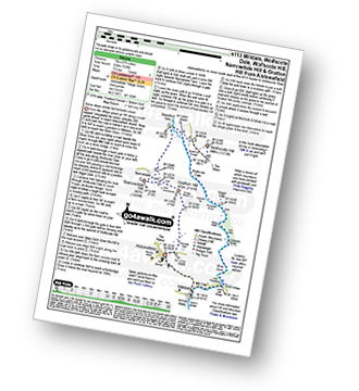
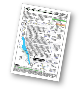
187 easy-to-follow circular walk route maps of all grades in The White Peak Area of The Peak District
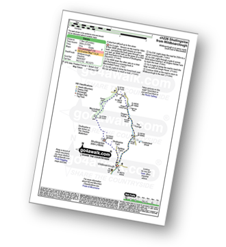
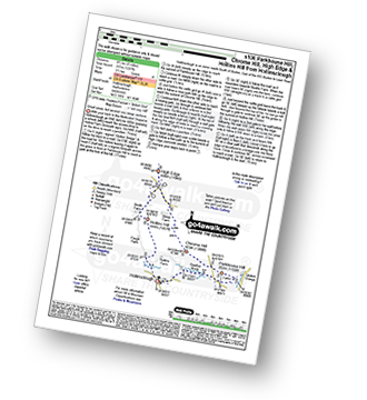
One hundred eighty-seven easy-to-follow, hand-crafted walks including routes from Birchover, Hulme End, Bakewell, Minninglow, Fenny Bentley, Chatsworth House, Elton, Longnor, Alstonefield, Dove Dale, Youlgreave, Litton, Milldale, Lamaload Reservoir, Ridgegate Reservoir, Lyme Park, Longshaw Country Park, Great Longstone, Binn Green, Flash, Ilam, Miller's Dale, Gradbach, Tideswell, Monsal Head, Monyash, Wye Dale, Baslow, Weag's Bridge, Mappleton, Hartington, Alsop en le Dale & Wildboarclough amongst many other locations. More details about each walk can be found below the map.
The White Peak Area of The Peak District National Park is area within the National Park boundary south of the A6 from Hazel Grove to Chapel-en-le-Frith, the A623 to Sparrowpit, the minor road from Sparrowpit along Rushup Edge to Castleton and the A6187 from Castleton to Sheffield.
Tap/mouse over a coloured circle (1-3 easy walks, 4-6 moderate walks, 7-9 hard walks) and click to select.
You can use these checkboxes to show only the grades of walk you are interested in:-
Scroll down the list of walks below & click on each walk title (in blue) to locate it on the map above.
See this list of walks, routes & maps in:
Grade Order | Length Order | Time Order | Walk Number or Start Location Order
NB. To reverse (toggle) this order, click Grade Order again
   |
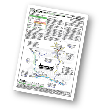
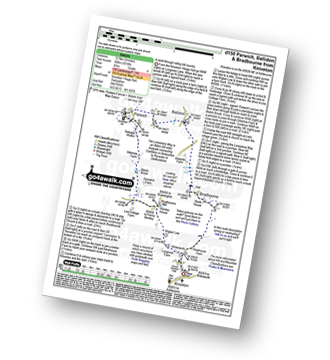
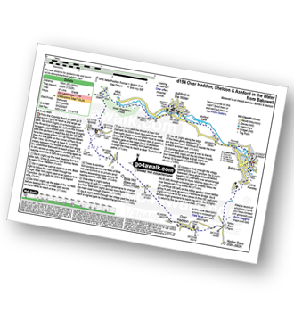
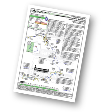
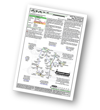
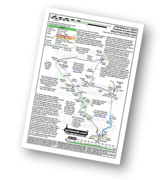
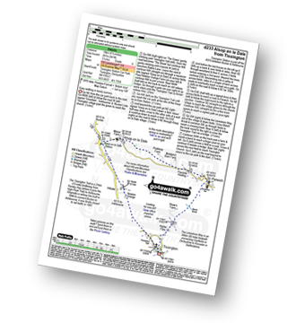
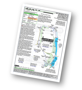
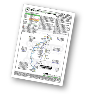
Vital Statistics:
| Length: | 7.25 miles (11.5 km) |
| Ascent: | 1,598ft (487m) |
| Time: | 4.25hrs |
| Grade: |  |
Route Summary:
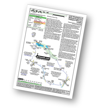
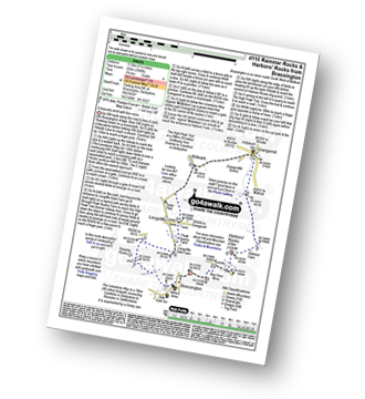
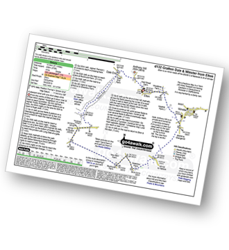
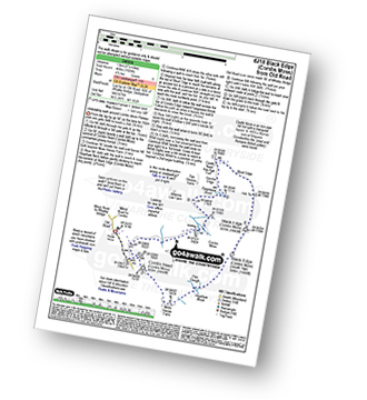
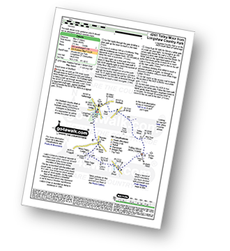
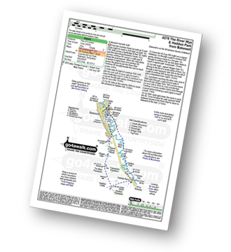
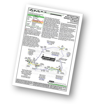
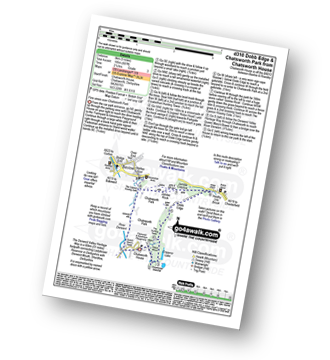
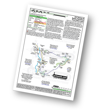
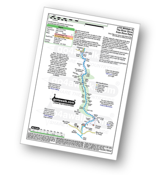
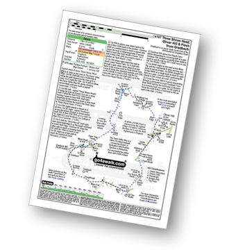
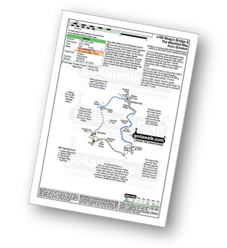
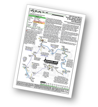
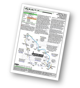
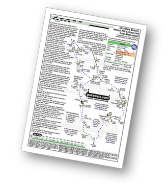
Ridgegate Reservoir - Leather's Smithy - Trentabank Reservoir - Higher Ridgegate - Macclesfield Forest - Shutlingsloe - Wildboarclough - Higher Nabbs Farm - Oaken Clough - Oakenclough Farm - Pot Lords - The Hanging Gate - The Gritstone Trail - Throstles Nest Farm - Ridgegate Reservoir
|
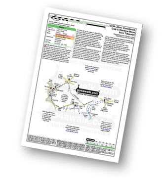
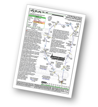
Vital Statistics:
| Length: | 8.5 miles (13.5 km) |
| Ascent: | 1,690ft (515m) |
| Time: | 4.75hrs |
| Grade: | |
Route Summary:
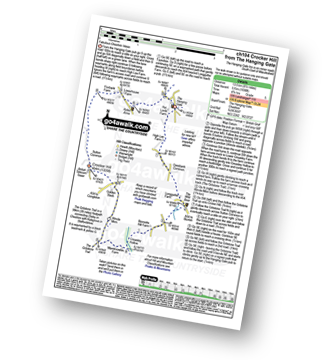
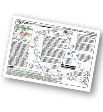
The Hanging Gate - Pot Lords - High Lee Farm - Withenshaw - Cessbank Common - Longgutter - Lower Greasley Farm - Greasley Hollow - Mareknowles Farm - The Gritstone Trail - Wincle Minn - Golden Slack - Croker Hill - Sutton Common - Foxbank Farm - Higher Sutton - Lowerhouse Farm - The Hanging Gate
|
Vital Statistics:
| Length: | 3.5 miles (5.5 km) |
| Ascent: | 840ft (256m) |
| Time: | 2.25hrs |
| Grade: |  |
Route Summary:
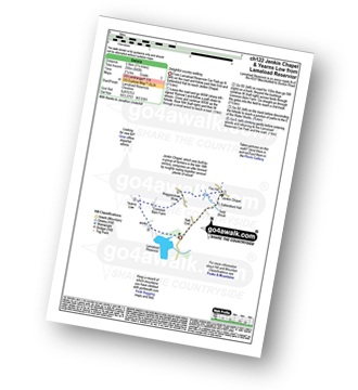
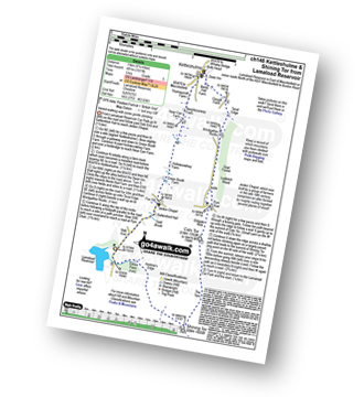
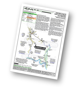
Lamaload Reservoir - Saltersford Hall - Jenkin Chapel - Waggonshaw Brow - Yearns Low - Lamaload Roservoir.
|
Vital Statistics:
| Length: | 7.25 miles (11.5 km) |
| Ascent: | 1,680ft (512m) |
| Time: | 4½ hrs |
| Grade: | |
Route Summary:
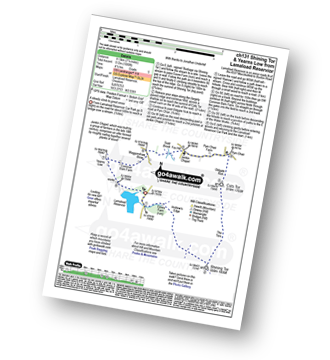
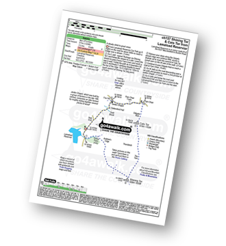
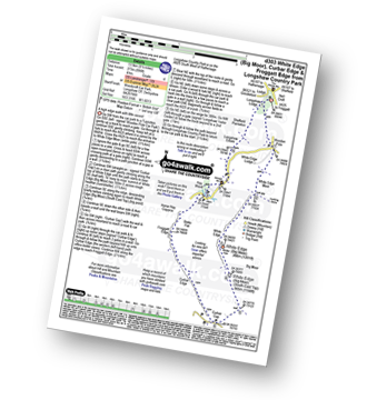
Lamaload Reservoir - Shining Tor - Cats Tor - Pym Chair - Jenkin Chapel - Waggonshaw Brow - Yearns Low - Lamaload Reservoir
|
Vital Statistics:
| Length: | 9.5 miles (15 km) |
| Ascent: | 1,611ft (491m) |
| Time: | 5 hrs |
| Grade: | |
Route Summary:
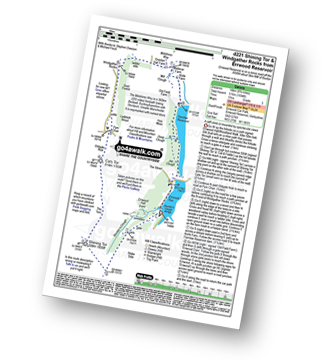
Lamaload Reservoir - Saltersford Hall - Jenkin Chapel - Kettleshulme - Windgather Rocks - Pym Chair - Cats Tor - Shining Tor - Lamaload Reservoir
|
Vital Statistics:
| Length: | 6.25 miles (10 km) |
| Ascent: | 1,451ft (442m) |
| Time: | 3.75hrs |
| Grade: |  |
Route Summary:
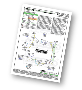
Pym Chair - Jenkin Chapel - Broad Moss - Saddle Cote - Moss Brook - Harrop Fold Farm - Black Brook - Charles Head Farm - Near Carr Farm - Fivelane-ends - Taxal Edge - Windgather Rocks - Goyt Forest - Ladbitch Wood - Pym Chair
|
Vital Statistics:
| Length: | 6.25 miles (10 km) |
| Ascent: | 1,224ft (373m) |
| Time: | 3½ hrs |
| Grade: | |
Route Summary:
Lamaload Reservoir - Shining Tor - Cats Tor - Pym Chair - Jenkin Chapel - Lamaload Reservoir
|
Vital Statistics:
| Length: | 9.75 miles (15.5 km) |
| Ascent: | 9ft (409m) |
| Time: | 5 hrs |
| Grade: | |
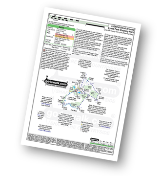
Route Summary:
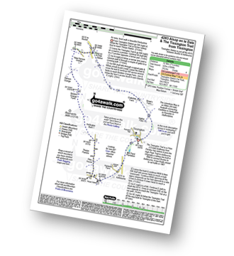
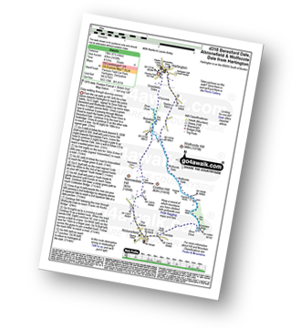
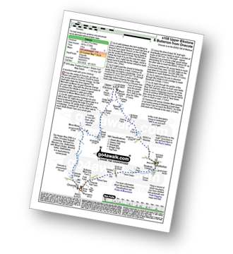
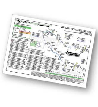
Nelson Pit Visitors Centre - Higher Poynton - The Macclesfield Canal - The Cheshire Ring Canal Walk - Wood Lanes - Adlington Basin - Lockgate Farm - The North Cheshire Way - Harrop Brow - Birchencliff Farm - Keeper's Cottage - Dale Top - Sponds Moor - The Gritstone Trail - Sponds Hill - Bowstonegate Farm - Bow Stones - Higher Moor - Lyme Park Country Park - Lantern Wood - The Cage - Lyme Hall - Fallow Deer Park - The Lime Avenue - Lyme Park Car Park - Windgather Farm - Haresteads Farm - Nelson Pit Visitors Centre - Higher Poynton.
|
Vital Statistics:
| Length: | 3.75 miles (11 km) |
| Ascent: | 1,415ft (431m) |
| Time: | 4 hrs |
| Grade: | |
Route Summary:
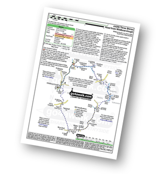
Wildboarclough - Clough House - Cumberland Brook - Cumberland Cottage - Danethorn Hollow - Wood Moss - The Dane Valley Way - Three Shires Head - Knarr Farm - Robins Clough - Bennettsitch Farm - Midgley Gate Farm - Burnt Cliff Top - Tagsclough Hill - Heild End Farm - Wildboarclough
|
Vital Statistics:
| Length: | 4.75 miles (7.5 km) |
| Ascent: | 886ft (270m) |
| Time: | 2½ hrs |
| Grade: | |
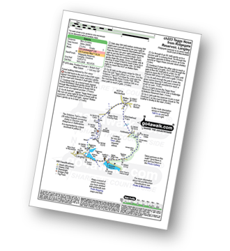
Route Summary:
Ridgegate Reservoir - Langley - Topclose Farm - Macclesfield Forest - Ashtreetop - Warrilowhead Farm - Walker Barn - Tegg's Nose Country Park - Tegg's Nose - Teggsnose Wood - Teggsnose Reservoir - Bottoms Reservoir - Langley - Ridgegate Reservoir
|
Vital Statistics:
| Length: | 4.75 miles (7.5 km) |
| Ascent: | 1,175ft (358m) |
| Time: | 3 hrs |
| Grade: | |
Route Summary:
Wildboarclough - Banktop Farm - Shutlingsloe Farm - Shutlingsloe - Macclesfield Forest - Ferriser - Dingers Hollow - Clough House - Wildboarclough
|
Vital Statistics:
| Length: | 8.25 miles (13 km) |
| Ascent: | 1,247ft (380m) |
| Time: | 4.25hrs |
| Grade: | |
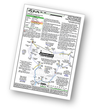
Route Summary:
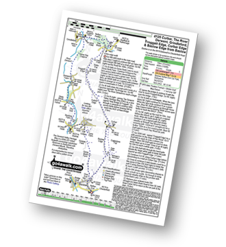
Cat and Fiddle - A537 Goyt's Moss - Whetstone Ridge - Danebower Hollow - A54 - Danebower Quarries - The River Dane - The Dane Valley Way - Orchard Farm - Three Shires Head - Panniers Pool - Cheeks Hill - Dane Head - Axe Edge (Axe Edge Moor) - A54 - Cat and Fiddle
|
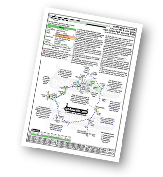
Vital Statistics:
| Length: | 7 miles (11 km) |
| Ascent: | 824ft (251m) |
| Time: | 3.25hrs |
| Grade: | |
Route Summary:
Nelson Pit Visitors Centre - Higher Poynton - The Macclesfield Canal - The Cheshire Ring Canal Walk - Wood Lanes - Adlington Basin - Lockgate Farm - The North Cheshire Way - Harrop Brow - West Parkgate - Lyme Park Country Park - Lyme Park Car Park - The Cage - Lyme Hall - Fallow Deer Park - The Lime Avenue - Lyme Park Car Park - Windgather Farm - Haresteads Farm - Nelson Pit Visitors Centre - Higher Poynton.
|
Vital Statistics:
| Length: | 4.5 miles (7 km) |
| Ascent: | 715ft (218m) |
| Time: | 2½ hrs |
| Grade: | |
Route Summary:
Lyme Park Car Park - Lyme Park Country Park - Pursefield Wood - Paddock Cottage,Knightslow Wood, - Higher Moor - Lantern Wood - The Cage - The North Cheshire Way - Lyme Hall - Lyme Park Car Park
|
Vital Statistics:
| Length: | 7.25 miles (11.5 km) |
| Ascent: | 1,201ft (366m) |
| Time: | 3.75hrs |
| Grade: | |
Route Summary:
Lyme Park Car Park - Crow Wood - Hase Bank Wood - West Parkgate - The North Cheshire Way - Keepers' Cottage - Dale Top - Sponds Moor - The Gritstone Trail - Sponds Hill - Bow Stones - Bowstonegate Farm - Lyme Park Country Park - Lantern Wood - The Cage - Fallow Deer Park - The Lime Avenue - Lyme Park Car Park
|
Vital Statistics:
| Length: | 7.5 miles (12 km) |
| Ascent: | 1,467ft (447m) |
| Time: | 4.25hrs |
| Grade: | |
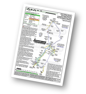
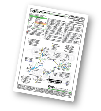
Route Summary:
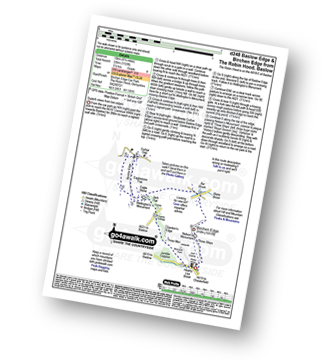
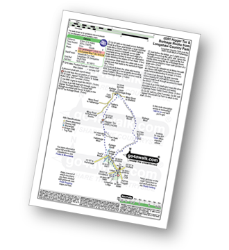
Grindleford Station - Padley Gorge - Lawrence Field - Toad's Mouth - Hathersage Moor - Carl Wark - Higger Tor - Fiddler's Elbow - Upper Burbage Bridge - Burbage Moor - Burbage Rocks - Longshaw Country Park - Sheffield Plantation - Nether Padley - Oaks Wood - Grindleford Station
|
Vital Statistics:
| Length: | 9.5 miles (15 km) |
| Ascent: | 2,071ft (631m) |
| Time: | 5½ hrs |
| Grade: |  |
Route Summary:
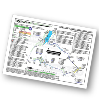
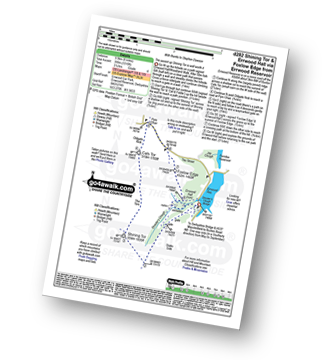
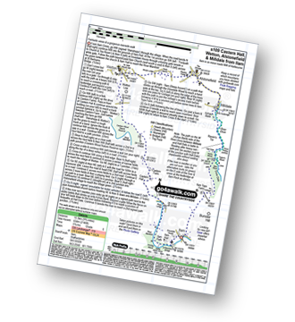
Errwood Reservoir - The Goyt Valley - Bunsal Cob - Wild Moor - Wildmoorstone Brook - Watford Moor - Beet Wood - Burbage Church - Buxton - Burbage Edge Plantation - Burbage Edge - Berry Clough - Goyt's Clough - Goyt's Moss - Deep Clough - Goytsclough Quarry - Stake Clough - Stake Side - The Goyt Valley - Errwood Hall - Errwood Reservoir
|
Vital Statistics:
| Length: | 10.5 miles (17 km) |
| Ascent: | 1,880ft (573m) |
| Time: | 5.75hrs |
| Grade: | |
Route Summary:
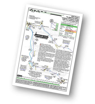
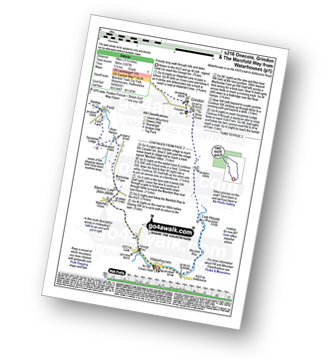
Monyash - The Limestone Way - Ferns Dale - One Ash Grange Farm - Cales Dale - Calling Low Farm - Low Moor Plantation - Moor Lane - Meadow Place Grange - Lathkill Dale - Over Haddon - Conksbury Bridge - Lathkill Dale - Twin Dale - Meadow Place Wood - Palmerston Wood - Calling Low Dale - Low Wood - Riklow Dale - Monyash
|
Vital Statistics:
| Length: | 8.25 miles (13 km) |
| Ascent: | 843ft (257m) |
| Time: | 3.75hrs |
| Grade: | |
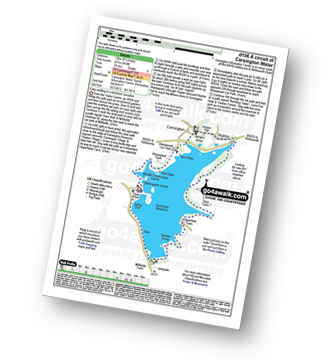
Route Summary:
Carsington Water Visitors Centre - Carsington Water Dam - Millfields - 'Wooden' House - Upperfield Farm - Hopton - Hopton Hall - Carsington - Sheepwash - Carsington Wildlife Conservation Centre - Carsington Water Visitors Centre
|
Vital Statistics:
| Length: | 7 miles (11 km) |
| Ascent: | 1,342ft (409m) |
| Time: | 3.75hrs |
| Grade: | |
Route Summary:
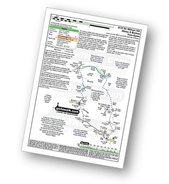
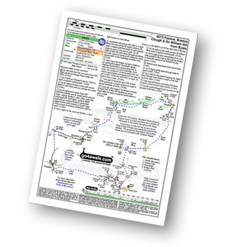
Bretton - Bretton Clough - Cockey Farm - Abney - Abney Clough - Stoke Ford - Mill Wood - Highlow Brook - Tor Farm - Hazelford - Leam - Eyam Moor - Sir William Hill - Bretton
|
Vital Statistics:
| Length: | 7.25 miles (11.5 km) |
| Ascent: | 1,080ft (329m) |
| Time: | 3.75hrs |
| Grade: | |
Route Summary:
Brassington - The Limestone Way - Rainster Rocks - Longcliffe - Aldwark - Grangemill - The Limestone Way - Grange Mill Quarry - Harboro' Farm - Harboro' Rocks - Bee Nest Mine - Brassington
|
Vital Statistics:
| Length: | 7.5 miles (12.5 km) |
| Ascent: | 722ft (220m) |
| Time: | 3½ hrs |
| Grade: | |
Route Summary:
Eyam - Town Head - Linen Dale - Foolow - Bretton Brook - Grange Farm - Abney Grange - Abney - Abney Clough - Stoke Ford - Bretton Brook - Bretton Clough - Bretton - Eyam Edge - Eyam
|
Vital Statistics:
| Length: | 6 miles (9.5 km) |
| Ascent: | 515ft (157m) |
| Time: | 2.75hrs |
| Grade: | |
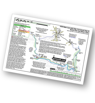
Route Summary:
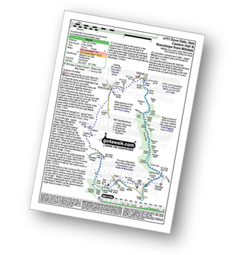
Miller's Dale Station - The Monsal Trail - The River Wye - Miller's Dale - Water-cum-Jolly Dale - Cressbrook Mill - The River Wye - Water-cum-Jolly Dale - Litton Mill - Bellamy's Bank - Miller's Dale Station
|
Vital Statistics:
| Length: | 7.5 miles (12 km) |
| Ascent: | 880ft (268m) |
| Time: | 3.75hrs |
| Grade: | |
Route Summary:
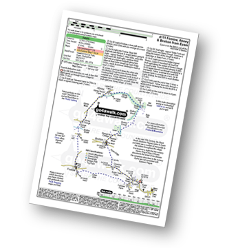
Taddington - Humphrey Gate - Slough Top - Chelmorton - The Midshires Way - Pomeroy - Flagg - Taddington.
|
Vital Statistics:
| Length: | 7.5 miles (12 km) |
| Ascent: | 1,766ft (538m) |
| Time: | 4½ hrs |
| Grade: | |
Route Summary:
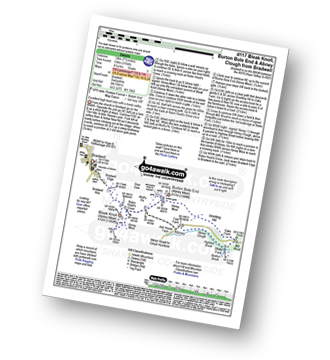
Bradwell - Bradwell Hills - Bradwell Edge - Robin Hood's Cross - Bleak Knoll (Abney Moor) - Durham Edge (Abney Moor) - Abney Moor - Wolf's Pit - Burton Bole End (Abney Moor) - Smelting Hill - Oaks Farm - Mill Wood - Stoke Ford - Highlow Brook - Abney Clough - Abney - Abney Moor - Bradwell
|
Vital Statistics:
| Length: | 5.75 miles (9 km) |
| Ascent: | 928ft (283m) |
| Time: | 3 hrs |
| Grade: | |
Route Summary:
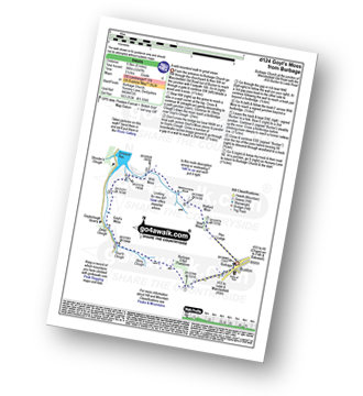
Peak Forest - Old Dam - Sweet Knoll Farm - Eldon Hole - Eldon Hill (Perryfoot) - Eldon Hill Quarries - The Limestone Way - Old Moor - Bradwell Moor - The Cop - West View - Old Dam - Peak Forest
|
Vital Statistics:
| Length: | 10 miles (16 km) |
| Ascent: | 1,509ft (460m) |
| Time: | 5.25hrs |
| Grade: | |
Route Summary:
Baslow - Baslow Nether End - Baslow Over End - Gorse Bank Farm - Grislow Field Farm - Lane Farm - Curbar - The Derwent Valley Heritage Way - The River Derwent - Stocking Farm - The Goit - New Bridge - Stoke Brook - Froggatt Bridge - Derwent Farm - Horse Hay Coppice - Grindleford - Grindleford Church - Hay Wood - Longshaw - Froggatt Edge - Curbar Edge - Curbar Gap - Baslow Edge - Eagle Stone - Wellington's Monument - Baslow
|
Vital Statistics:
| Length: | 6.5 miles (10.5 km) |
| Ascent: | 1,283ft (391m) |
| Time: | 3.75hrs |
| Grade: | |
Route Summary:
Buxton (Burbage Church) - Burbage Edge Plantation - Burbage Edge - Berry Clough - Goyt's Clough - Goyt's Moss - Goytsclough Quarry - The Goyt Valley - Wild Moor - Wildmoorstone Brook - Watford Moor - Beet Wood - Buxton (Burbage Church)
|
Vital Statistics:
| Length: | 8.25 miles (13 km) |
| Ascent: | 1,122ft (342m) |
| Time: | 4.25hrs |
| Grade: | |
Route Summary:
Beeley - Moor Farm - Beeley Plantation - Rabbit Warren - Beeley Brook - Hob Hurst's House - Harland Edge - Beeley Moor - Beeley Moor (South East Top) - Beeley Lane - Harland Sick - Hell Bank Plantation - Fallinge Farm - Smeltingmill Wood - Fold Farm - Beeley
|
Vital Statistics:
| Length: | 12.75 miles (19 km) |
| Ascent: | 2,258ft (688m) |
| Time: | 6.75hrs |
| Grade: |  |
Route Summary:
Bradwell - Jennings Dale - Little Hucklow - Windmill - Great Hucklow - Bretton - Bretton Moor - Bretton Brook - Stoke Ford - Oaks Farm - Smelting Hill - Abney Moor - Burton Bole End (Abney Moor) - Wolf's Pit - Shatton Edge - Shatton Hope Valley - Townfield Barn - Elmore Hill Farm - Bothams Farm - Bradwell
|
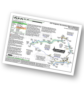
Vital Statistics:
| Length: | 4 miles (6 km) |
| Ascent: | 610ft (186m) |
| Time: | 2.25hrs |
| Grade: | |

Route Summary:
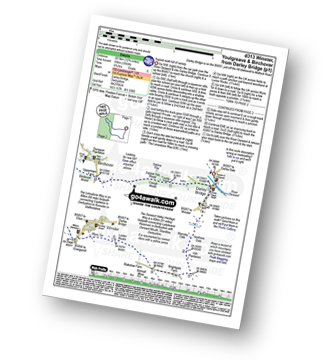
Youlgreave - Bradford Dale - River Bradford - The Limestone Way - River Lathkill - Lathkill Dale - Conksbury Bridge - Youlgreave
|
Vital Statistics:
| Length: | 6 miles (9.5 km) |
| Ascent: | 565ft (172m) |
| Time: | 2.75hrs |
| Grade: | |
Route Summary:
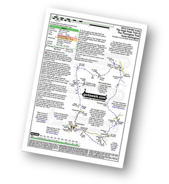
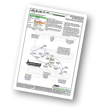
Monyash - Moscar Farm - The High Peak Trail - Parsley Hay - Hardlow - Sparklow - Bull I' Th' Thorn Inn - Newton Farm - Hutmoor Butts - The Limestone Way - Dalehouse Farm - Monyash
|
Vital Statistics:
| Length: | 6.75 miles (11 km) |
| Ascent: | 876ft (267m) |
| Time: | 3½ hrs |
| Grade: | |
Route Summary:
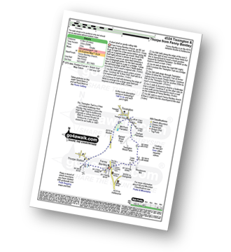
Mappleton Lane (Ashbourne) - The Tissington Trail - Thorpe - The Limestone Way - Coldwall Bridge - River Dove - Big Peg's Wood - Little Peg's Wood - Littlepark Farm - Mappleton (aka Mapleton) - Callow Top - Mappleton Lane (Ashbourne)
|
Vital Statistics:
| Length: | 8.5 miles (13.5 km) |
| Ascent: | 978ft (298m) |
| Time: | 4 hrs |
| Grade: | |
Route Summary:
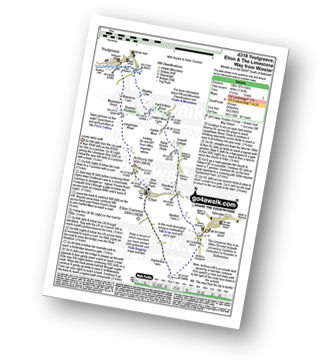
Elton - Anthony Hill - Dale End (Elton) - Gratton Dale - Mouldridge Grange - Rockhurst Farm - Greenlow Farm - Winster - The Limestone Way - Elton
|
Vital Statistics:
| Length: | 6.25 miles (10 km) |
| Ascent: | 1,246ft (380m) |
| Time: | 3½ hrs |
| Grade: | |
Route Summary:
Eyam - Sir William Hill - Eyam Moor - Bole Hill (Highlow) - Stoke Ford - Abney Clough - Abney - Cockey Farm - Bretton Clough - Bretton - Eyam
|
Vital Statistics:
| Length: | 9.5 miles (15.5 km) |
| Ascent: | 705ft (215m) |
| Time: | 1.25hrs |
| Grade: | |
Route Summary:
Alsop en le Dale Station - New Hanson Grange - Milldale - River Dove - Mill Dale - Lode Mill Bridge - Coldeaton Bridge - Iron Tors - Gipsy Bank - Drabber Tor - Peasland Rocks - Wolfscote Dale - Biggin Dale - Furny Bottom - Dale End (Heathcote) - Biggin - The Tissington Trail - Alsop en le Dale Station
|
Vital Statistics:
| Length: | 8.5 miles (13.5 km) |
| Ascent: | 1,099ft (335m) |
| Time: | 4.25hrs |
| Grade: | |
Route Summary:
Tissington - The Tissington Trail - Alsop en le Dale Station - Oxdales Farm - Eaton Dale - Eatondale Wood - Flaxdale Holding - Parwich - Bletch Brook - Higher Flats - Tissington
|
Vital Statistics:
| Length: | 7.25 miles (11.5 km) |
| Ascent: | 1,411ft (430m) |
| Time: | 4 hrs |
| Grade: | |
Route Summary:
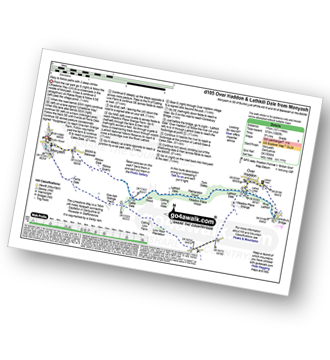
Tideswell - The Limestone Way - Monksdale House - Monks Dale - Miller's Dale Station - The Monsal Trail - Miller's Dale - The River Wye - Litton Mill - Tideswell Dale - Tideswell
|
Vital Statistics:
| Length: | 6.75 miles (11 km) |
| Ascent: | 1,122ft (342m) |
| Time: | 3.75hrs |
| Grade: | |
Route Summary:
Hay Wood - Longshaw - Froggatt Edge - Curbar Edge - Curbar - The Derwent Valley Heritage Way - The River Derwent - Stocking Farm - The Goit - New Bridge - Stoke Brook - Froggatt Bridge - Derwent Farm - Horse Hay Coppice - Grindleford - Grindleford Church - Hay Wood
|
Vital Statistics:
| Length: | 12.25 miles (19.5 km) |
| Ascent: | 1,930ft (588m) |
| Time: | 6½ hrs |
| Grade: | |
Route Summary:
Mappleton Lane (Ashbourne) - The Tissington Trail - Thorpe - Pike House - Bostern Grange Farm - Hanson Grange - The Nabs - Dove Dale - Dove Holes - Taylors Wood - Pickering Rock - Ilam Rock - Shaplow Dale - Lin Dale - Thorpe Cloud - Thorpe Mill Farm - The Limestone Way - Coldwall Bridge - River Dove - Big Peg's Wood - Little Peg's Wood - Littlepark Farm - Mappleton (aka Mapleton) - Callow Top - Mappleton Lane (Ashbourne)
|
Vital Statistics:
| Length: | 10.5 miles (16.5 km) |
| Ascent: | 1,287ft (392m) |
| Time: | 5 hrs |
| Grade: | |
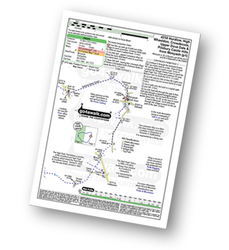
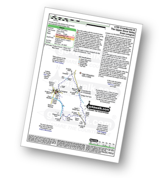
Route Summary:
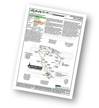
Earl Sterndale - Hindlow Quarry - Dowlow Works - The Midshires Way - The High Peak Trail - Pomeroy - Hurdlow - Parsley Hay - Darley Farm - Vincent House - Pilsbury - Pilsbury Castle Hills - Upper Dove Dale - Bridge End Farm - Crowdecote - Meadow Farm - Underhill Farm - Hitter Hill - Earl Sterndale
|
Vital Statistics:
| Length: | 5.75 miles (9 km) |
| Ascent: | 1,046ft (319m) |
| Time: | 3.25hrs |
| Grade: | |
Route Summary:
Winster - Upper Town - Uppertown Farm - Rocking Stone Farm - Birchover - Stanton Moor - Cork Stone - Nine Ladies Stone Circle - The Reform Tower (or Earl Grey Tower) - Winster
|
Vital Statistics:
| Length: | 9.75 miles (15.5 km) |
| Ascent: | 1,001ft (305m) |
| Time: | 4.75hrs |
| Grade: | |
Route Summary:
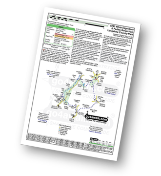
Curbar Gap - Curbar Edge - Froggatt Edge - Hay Wood - Longshaw (A621) - White Edge Lodge - White Edge Moor - Barbrook Bridge - Barbrook Reservoir - Bar Brook - Big Moor - Ramsley Moor - Ramsley Reservoir - Blake Brook - Wellington's Monument - Eagle Stone - Eaglestone Flat - Baslow Edge - Curbar Gap
|
Vital Statistics:
| Length: | 9.75 miles (15.5 km) |
| Ascent: | 1,240ft (378m) |
| Time: | 4.75hrs |
| Grade: | |
Route Summary:
Middleton-by-Youlgreave - River Bradford - Rusden Wood - Gratton Moor - Long Dale - Bolderstone Plantation - Friden Station - The High Peak Trail - Green Lane (Friden) - Mere Farm - Ringham Low (Friden) - Kenslow Farm - Kenslow Knoll - Little Rockery Plantation - Rake Wood - Middleton-by-Youlgreave
|
Vital Statistics:
| Length: | 9.75 miles (15.5 km) |
| Ascent: | 735ft (224m) |
| Time: | 5.25hrs |
| Grade: | |
Route Summary:
Thorpe - The Tissington Trail - Lin Dale - Dove Dale - The River Dove - Stepping Stones - Lover's Leap - Tissington Spires - Shaplow Dale - Dove Holes - Milldale - Mill Dale - Alsop en le Dale - The Tissington Trail - Tissington - Thorpe
|
Vital Statistics:
| Length: | 8 miles (12.5 km) |
| Ascent: | 1,010ft (305m) |
| Time: | 4 hrs |
| Grade: | |
Route Summary:
Kniveton - Whitelands - Wigber Low - Bradbourne Mill - Bletch Brook - Sitterlow Farm - Parwich - Ballidon - Bradbourne - Newhouse Farm - Kniveton
|
Vital Statistics:
| Length: | 7.75 miles (12.5 km) |
| Ascent: | 1,532ft (467m) |
| Time: | 4½ hrs |
| Grade: | |
Route Summary:
Over Haddon - River Lathkill - Conksbury Bridge - Raper Lodge - Youlgreave - River Bradford - The Limestone Way - Bradford Dale - Lomber Dale - Lomberdale Hall - Moor Lane - Low Moor Plantation - Calling Low Farm - Cales Dale - Lathkill Dale - Low Wood - Calling Low Dale - Palmerston Wood - Meadow Place Wood - Twin Dale - Lathkill Lodge - Over Haddon
|
Vital Statistics:
| Length: | 15 miles (24 km) |
| Ascent: | 1,831ft (558m) |
| Time: | 7.25hrs |
| Grade: | |
Route Summary:
Hurdlow - Sparklow - The High Peak Trail - Hutmoor Butts - The Limestone Way - Monyash - One Ash Grange Farm - Calling Low Farm - Cales Dale - Moor Lane - Youlgreave - Lomberdale Hall - Middleton-by-Youlgreave - Rake Wood - Little Rookery Plantation - Kenslow Farm - Kenslow Knoll - Ringham Low (Friden) - Mere Farm - Green Lane (Friden) - The High Peak Trail - Sparklow - Hurdlow
|
Vital Statistics:
| Length: | 15.5 miles (24.5 km) |
| Ascent: | 1,742ft (531m) |
| Time: | 7.25hrs |
| Grade: | |
Route Summary:
Tissington - The Tissington Trail - Thorpe Station - Thorpe - Pike House - Thorpe Pasture - Bostern Grange Farm - Milldale - River Dove - Mill Dale - Lode Mill Bridge - Coldeaton Bridge - Wolfscote Dale - Biggin Dale - Biggin - The Tissington Trail - Alsop en le Dale Station - Tissington
|
Vital Statistics:
| Length: | 9.5 miles (15 km) |
| Ascent: | 1,332ft (406m) |
| Time: | 4.75hrs |
| Grade: | |
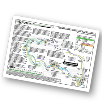
Route Summary:
Bakewell - Noton Barn Farm - Noton Barn - Over Haddon - Bole Hill (Bakewell) - Kirk Dale - Sheldon - Great Shackleton Wood - River Wye - Ashford In The Water - River Wye - Holme Bridge - Bakewell
|
Vital Statistics:
| Length: | 11.25 miles (18 km) |
| Ascent: | 1,759ft (536m) |
| Time: | 5.75hrs |
| Grade: | |
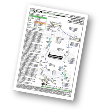
Route Summary:
Bradwell - Bradwell Hills - Bradwell Edge - Robin Hood's Cross - Bleak Knoll (Abney Moor) - Durham Edge (Abney Moor) - Abney Moor - Abney Grange - Bretton Brook - Great Hucklow - Windmill - High Rake Mine - High Rake - Tideslow Rake - Tides Low - New Farm - Tideswell Moor - Bradwell Moor - Old Moor - Potter Barn - Smalldale Hall - Bradwell
|
Vital Statistics:
| Length: | 5.5 miles (9 km) |
| Ascent: | 984ft (300m) |
| Time: | 3 hrs |
| Grade: | |
Route Summary:
Elton - The Limestone Way - Dudwood Lane - Birchover - The Mires - Robin Hood's Stride - Harthill Moor Wood - Cliffe Farm - Anthony Hill - Elton
|
Vital Statistics:
| Length: | 8.75 miles (14 km) |
| Ascent: | 1,414ft (431m) |
| Time: | 4.75hrs |
| Grade: | |
Route Summary:
Calton Lees - Lees Wood - Calton Plantation - New Piece Wood - Maud's Plantations - Edensor - Edensor Forest Nursery - Ballcross Farm - Moatless Plantation - Calton Pastures - Manners Wood - Lees Moor Wood - Bouns Corner - Rowsley - The Derwent Valley Heritage Way - River Derwent - Bank Wood - Calton Lees
|
Vital Statistics:
| Length: | 6 miles (9.5 km) |
| Ascent: | 532ft (162m) |
| Time: | 2.75hrs |
| Grade: | |
Route Summary:
Monsal Head - Upperdale - The River Wye - Cressbrook Mill - The River Wye - Water-cum-Jolly Dale - Litton Mill - The Monsal Trail - Water-cum-Jolly Dale - Monsal Head Viaduct - Monsal Head
|
Vital Statistics:
| Length: | 12.75 miles (20.5 km) |
| Ascent: | 1,959ft (597m) |
| Time: | 6.75hrs |
| Grade: | |
Route Summary:
Peak Forest - Dam Dale - Hay Dale - Dale Head - Peter Dale - Monk's Dale - Miller's Dale - The Monsal Trail - Litton Mill - Tideswell Dale - Tideswell - Brook Bottom (Tideswell) - Batham Gate - Old Peak - Peak Forest
|
Vital Statistics:
| Length: | 7.5 miles (12 km) |
| Ascent: | 1,335ft (407m) |
| Time: | 4.25hrs |
| Grade: | |
Route Summary:
Stanton in Peak - Nine Ladies Stone Circle - The Reform Tower (or Earl Grey Tower) - Cork Stone - Stanton Moor - Birchover - The Limestone Way - Robin Hood's Stride - Harthill Moor - Harthill Moor Farm - River Bradford - Bradford Dale - Rhienstor Plantation - Alport - Tolls Wood - Stanton in Peak
|
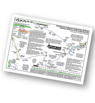
Vital Statistics:
| Length: | 3.5 miles (5.5 km) |
| Ascent: | 528ft (161m) |
| Time: | 2 hrs |
| Grade: |  |
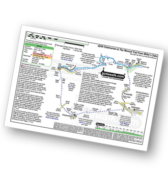
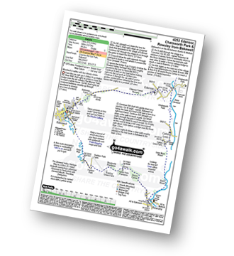
Route Summary:
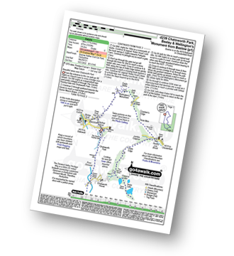
Chatsworth House - Stand Wood Ornamental Waterfall - Chatsworth Elizabethan Hunting Tower - Chatsworth Park - The Cannon Kissing Gate - Baslow - The Derwent Valley Heritage Way - Chatsworth House
|
Vital Statistics:
| Length: | 9.75 miles (15.5 km) |
| Ascent: | 2,074ft (632m) |
| Time: | 6 hrs |
| Grade: | |
Route Summary:
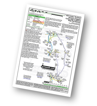
Stoney Middleton - The Cliff - Eyam - Sir William Hill - Eyam Moor - Bole Hill (Highlow) - Bretton Brook - Stoke Ford - Mill Wood - Brook Wood - Highlow Brook - Hazleford - Hazleford Hall - Leadmill - Leadmill Bridge - River Derwent - The Derwent Valley Heritage Way - Coppice Wood - Burbage Brook - Grindleford - Horse Hay Coppice - Derwent Farm - Froggatt Bridge - Knouchley Farm - Stoney Middleton
|
Vital Statistics:
| Length: | 5.25 miles (8.5 km) |
| Ascent: | 939ft (286m) |
| Time: | 3 hrs |
| Grade: | |
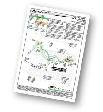
Route Summary:
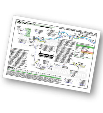
Wye Dale - Topley Pike Quarry - Deep Dale - Horseshoe Dale - Bullhay Dale - Chelmorton - The Midshires Way - Marl Dale - Wye Dale
|
Vital Statistics:
| Length: | 9 miles (14.5 km) |
| Ascent: | 1,453ft (446m) |
| Time: | 4.75hrs |
| Grade: | |
Route Summary:
Tissington - The Tissington Trail - Thorpe Station - Thorpe - Pike House - Thorpe Pasture - Bostern Grange Farm - Alsop en le Dale Station - Parwich - The Limestone Way - Tissington
|
Vital Statistics:
| Length: | 8.5 miles (13.5 km) |
| Ascent: | 1,749ft (533m) |
| Time: | 5.75hrs |
| Grade: | |
Route Summary:
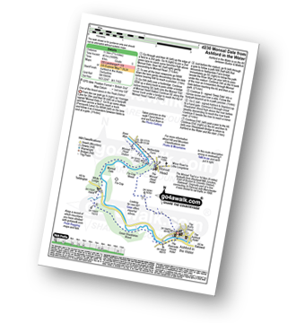
Ashford In The Water - Fin Cop - Monsal Head - Upperdale - The River Wye - The Monsal Trail - Monsal Head Viaduct - Monsal Dale - White Lodge - Great Shackleton Wood - Ashford In The Water
|
Vital Statistics:
| Length: | 4 miles (6.5 km) |
| Ascent: | 942ft (287m) |
| Time: | 2½ hrs |
| Grade: | |
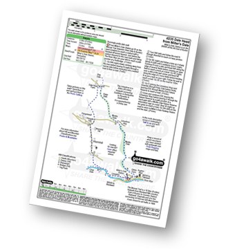
Route Summary:
Miller's Dale Station - Monks Dale - The Limestone Way - Monksdale House - The River Wye - Millers Dale - The Monsal Trail - Miller's Dale Station
|
Vital Statistics:
| Length: | 3.75 miles (6 km) |
| Ascent: | 660ft (200m) |
| Time: | 3 hrs |
| Grade: | |
Route Summary:
Elton - The Limestone Way - Dudwood Lane - Robin Hood's Stride - Harthill Moor Wood - Cliffe Farm - Anthony Hill - Elton
|
Vital Statistics:
| Length: | 4 miles (6.5 km) |
| Ascent: | 400ft (122m) |
| Time: | 2 hrs |
| Grade: | |

Route Summary:
Hell Bank Plantation - Beeley Plantation - Rabbit Warren - Beeley Brook - Hob Hurst's House - Harland Edge - Beeley Moor - Beeley Moor (South East Top) - Beeley Lane - Harland Sick - Hell Bank Plantation
|
Vital Statistics:
| Length: | 10.75 miles (17 km) |
| Ascent: | 1,493ft (455m) |
| Time: | 5½ hrs |
| Grade: | |
Route Summary:
Grindleford Station - Oaks Wood - Nether Padley - White Edge Moor - Hurkling Stone - White Edge - White Edge (Big Moor) - White Edge (Big Moor) (South East Top) - Curbar Gap - Baslow Edge - Eaglestone Flat - Eagle Stone - Wellington's Monument - Over End - Baslow - The Derwent Valley Heritage Way - Bridge End - River Derwent - Bubnell - Townend Wood - St Mary's Wood - Curbar - Stocking Farm - New Bridge - Froggatt Bridge - Derwent Farm - Horse Hay Coppice - Grindleford - Grindleford Station
|
Vital Statistics:
| Length: | 4 miles (6.5 km) |
| Ascent: | 638ft (194m) |
| Time: | 2.25hrs |
| Grade: | |
|
Vital Statistics:
| Length: | 6.5 miles (10.5 km) |
| Ascent: | 1,145ft (349m) |
| Time: | 3½ hrs |
| Grade: | |
Route Summary:
Youlgreave - Bradford Dale - River Bradford - Mawstone Farm - Bleakley Plantation - Longshawe Wood - Anthony Hill - Elton - The Limestone Way - Robin Hood's Stride - Harthill Moor - Harthill Moor Wood - Bleakley Dike - River Bradford - Bradford Dale - Youlgreave
|
Vital Statistics:
| Length: | 9.75 miles (15.5 km) |
| Ascent: | 1,431ft (436m) |
| Time: | 5 hrs |
| Grade: | |
Route Summary:
Miller's Dale Station - Monks Dale - The Limestone Way - Tideswell - Litton - Tansley Dale - Cressbrook Dale - Cressbrook - The Monsal Trail - Water-cum-Jolly Dale - Litton Mill - Miller's Dale - Miller's Dale Station
|
Vital Statistics:
| Length: | 6.5 miles (10.5 km) |
| Ascent: | 1,115ft (340m) |
| Time: | 3½ hrs |
| Grade: | |
Route Summary:
Rowsley - Holly Wood - Stanton Woodhouse Farm - Stanton Moor - The Reform Tower (or Earl Grey Tower) - The Cork Stone - Nine Ladies Stone Circle - Stanton in Peak - Smithy Wood - Congreave Farm - Rowsley
|
Vital Statistics:
| Length: | 7.75 miles (12.5 km) |
| Ascent: | 840ft (256m) |
| Time: | 3.75hrs |
| Grade: | |
Route Summary:
Miller's Dale Station - The Monsal Trail - The River Wye - Miller's Dale - Water-cum-Jolly Dale - Monsal Head Viaduct - Monsal Head - Upperdale - Cressbrook Mill - The River Wye - Water-cum-Jolly Dale - Litton Mill - Bellamy's Bank - Miller's Dale Station
|
Vital Statistics:
| Length: | 9.75 miles (15.5 km) |
| Ascent: | 1,342ft (409m) |
| Time: | 5 hrs |
| Grade: | |
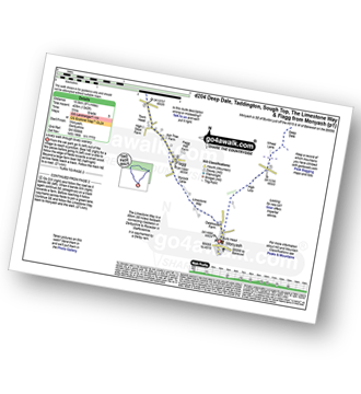
Route Summary:
Monyash - High Low - Wheal Lane - Deep Dale - White Lodge (A6) - Taddington Field - Lodley View Farm - Taddington - Sough Top - The Limestone Way - Flagg - Monyash
|
Vital Statistics:
| Length: | 10 miles (16 km) |
| Ascent: | 1,578ft (481m) |
| Time: | 5.25hrs |
| Grade: | |
Route Summary:
Bakewell - The Monsal Trail - Hassop Station. Great Longstone Station - Little Longstone - Monsal Head - Monsal Dale - River Wye - Great Shackleton Wood - Magpie Sough - Ashford In The Water - River Wye - Holme Bridge - Bakewell
|
Vital Statistics:
| Length: | 8.75 miles (14 km) |
| Ascent: | 1,473ft (449m) |
| Time: | 4.75hrs |
| Grade: | |
Route Summary:
Hartington - Crossland Sides - Pennilow - Beresford Dale - Pike Pool - How Narrowdale - The Rakes - Alstonefield - Overdale - Gipsy Bank - River Dove - Coldeaton Bridge - Iron Tors - Drabber Tor - Wolfscote Dale - Peasland Rocks - Biggin Dale - Furny Bottom - Dale End - Biggin - Hartington
|
Vital Statistics:
| Length: | 6.5 miles (10.5 km) |
| Ascent: | 1,165ft (355m) |
| Time: | 3½ hrs |
| Grade: | |
Route Summary:
White Lodge - Monsal Dale - Deep Dale - Sheldon - Ashford In The Water - The River Wye - Great Shackleton Wood - White Lodge
|
Vital Statistics:
| Length: | 7.25 miles (12.5 km) |
| Ascent: | 1,007ft (307m) |
| Time: | 4 hrs |
| Grade: | |
Route Summary:
Tissington - The Tissington Trail - Thorpe Station - Fenny Bentley - Woodeaves Mill - Woodeaves Farm - Lea Hall - Lee Cottage Farm - Bletch Book - Sittlerlow Farm - Parwich - The Limestone Way - Bletch Brook - The Tissington Trail - Tissington
|
Vital Statistics:
| Length: | 6.5 miles (10.5 km) |
| Ascent: | 735ft (224m) |
| Time: | 3 hrs |
| Grade: | |
Route Summary:
Baslow - The Cannon Kissing Gate - Chatsworth Park - Stand Wood - Elizabethan Hunting Tower - Emperor Lake - Swidd Lake - Rabbit Warren - Beeley Hilltop Farm - Beeley Lodge - Calton Lees - Chatsworth Park - The Derwent Valley Heritage Way - Queen Mary's Tower - Chatsworth House - Chatsworth Park - Baslow
|
Vital Statistics:
| Length: | 9.5 miles (15 km) |
| Ascent: | 1,792ft (546m) |
| Time: | 5.25hrs |
| Grade: | |
Route Summary:
Eyam - Eyam Dale - Middleton Dale - Dalton Quarry - High Fields - Black Harry Lane - Black Harry Gate - Blakedon Hollow - Longstone Edge - High Rake - Deep Rake - Bramley Wood - Bramley Farm - Townend Wood - The Dane Valley Heritage Way - St Mary's Wood - Calver - Stoney Middleton - The Cliff - Eyam
|
Vital Statistics:
| Length: | 8.25 miles (13 km) |
| Ascent: | 1,358ft (414m) |
| Time: | 4½ hrs |
| Grade: | |
Route Summary:
Winster - Luntor Rocks - The Limestone Way - Blakelow Hill - Bonsall Moor - Upper Town - Bonsall - Slaley - Dunsley Springs - Bonsall Wood - Ible Wood - Whitelow Farm - Bonsall Moor - Wyns Tor - Winster
|
Vital Statistics:
| Length: | 8.25 miles (13 km) |
| Ascent: | 1,509ft (460m) |
| Time: | 4½ hrs |
| Grade: | |
Route Summary:
Old Road - Combs Moss - Combs Head (Combs Moss) - Moss House Farm - Hogshaw Brook - Flint Clough - Black Edge (Combs Moss) (South Top) - Black Edge (Combs Moss) - Hob Tor - Short Edge - Castle Naze (Hill Fort) - Combs Edge - Pyegreave Brook - Allstone Lee Farm - Combs Moss - Old Road
|
Vital Statistics:
| Length: | 8.75 miles (14 km) |
| Ascent: | 1,694ft (516m) |
| Time: | 5 hrs |
| Grade: | |
Route Summary:
Errwood Reservoir - The Goyt Valley - Shooter's Clough - Shining Tor - The Tors - Cats Tor - Oldgate Nick - Pym Chair - Goyt Forest - Windgather Rocks - Taxal Edge - Overton Hall Farm - The Midshires Way - Madscar Farm - Mill Clough - Knife Farm - The Goyt Valley - Fernilee Reservoir - Hoo Moor - Deep Clough - Jep Clough - The Street - The Goyt Valley - Errwood Reservoir
|
Vital Statistics:
| Length: | 6.5 miles (10.5 km) |
| Ascent: | 1,241ft (378m) |
| Time: | 3.75hrs |
| Grade: | |

Route Summary:
Bradwell - Bradwell Hills - Bradwell Edge - Robin Hood's Cross - Bleak Knoll (Abney Moor) - Durham Edge (Abney Moor) - Abney Moor - Abney Grange - Bretton Brook - Great Hucklow - Windmill - Little Hucklow - Coplow Dale - Intake Dale - Bradwell Dale - Bradwell
|
Vital Statistics:
| Length: | 13.5 miles (21.5 km) |
| Ascent: | 1,286ft (392m) |
| Time: | 6.25hrs |
| Grade: | |
Route Summary:
Hartington - Sheen - Brund - Manifold Valley - Longnor - Crowdecote (Crowdicote) - Bridge End Farm - Upper Dove Dale - Pilsbury Castle Hills - Vincent House - Darley Farm - The High Peak Trail - Parlsey Hay - The Tissington Trail - Hartington Station - Heathcote - Heathcote Mere - Highfield Lane - Hartington
|
Vital Statistics:
| Length: | 7.25 miles (11.5 km) |
| Ascent: | 1,480ft (451m) |
| Time: | 4 hrs |
| Grade: | |
Route Summary:
Ashford In The Water - Monsal Head - Upperdale - The River Wye - The Monsal Trail - Monsal Head Viaduct - Monsal Dale - White Lodge - Great Shackleton Wood - Ashford In The Water
|
Vital Statistics:
| Length: | 6.25 miles (10 km) |
| Ascent: | 941ft (287m) |
| Time: | 3.25hrs |
| Grade: | |
Route Summary:
Tissington - Newton Grange - The Tissington Trail - Alsop en le Dale Station - Alsop en le Dale - Flaxdale Holding - Parwich - Bletch Brook - Higher Flats - Tissington
|
Vital Statistics:
| Length: | 5.25 miles (8.5 km) |
| Ascent: | 709ft (216m) |
| Time: | 2.75hrs |
| Grade: | |
Route Summary:
Tideswell - Litton Dale - Litton - Tansley Dale - Cressbrook Dale - Peter's Stone - Wardlow Mires - Litton Edge - Lane Head - Tideswell
|
Vital Statistics:
| Length: | 6 miles (9.5 km) |
| Ascent: | 1,175ft (358m) |
| Time: | 3½ hrs |
| Grade: | |
Route Summary:
Miller's Dale Station - The Monsal Trail - River Wye - Wormhill - Dale Head - Peter Dale - Monk's Dale - Miller's Dale - Miller's Dale Station
|
Vital Statistics:
| Length: | 10.25 miles (16.5 km) |
| Ascent: | 1,477ft (450m) |
| Time: | 5.25hrs |
| Grade: | |
Route Summary:
Bakewell - All Saints Church - Burton Moor - Ditch Cliff - Over Haddon - River Lathkill - Lathkill Dale - Meadow Place Grange - Youlgreave - River Bradford - Bradford Dale - River Lathkill - Lathkill Dale - Conksbury Bridge - Noton Barn - Haddon Fields - Haddon Barn - Haddon Park - River Wye - Bakewell
|
Vital Statistics:
| Length: | 11.75 miles (19 km) |
| Ascent: | 1,559ft (475m) |
| Time: | 5.75hrs |
| Grade: | |
Route Summary:
Baslow - The Cannon Kissing Gate - Chatsworth Park - Queen Mary's Bower - Chatsworth House - River Derwent - Calton Lees - Beeley Lodge - Beeley - Beeley Plantation - Hell Bank Plantation - Ravvut Warren - Stand Wood - Swiss Lake - Emperor Lake - Elizabethan Hunting Lodge - Dobb Edge - Heathy Lea Brook - Robin Hood (Baslow) - Birchen Edge Car Park - Three Men - Cupola Cottage - Jack Flat - Wellington's Monument - Eagle Stone - Baslow
|
Vital Statistics:
| Length: | 6.5 miles (10.5 km) |
| Ascent: | 1,063ft (324m) |
| Time: | 3½ hrs |
| Grade: | |
Route Summary:
Tideswell - Litton - Tansley Dale - Cressbrook Dale - Cressbrook - The Monsal Trail - Water-cum-Jolly Dale - Litton Mill - Tideswell Dale - Litton Dale - Tideswell
|
Vital Statistics:
| Length: | 4.5 miles (7 km) |
| Ascent: | 804ft (245m) |
| Time: | 2½ hrs |
| Grade: | |
Route Summary:
Longshaw Country Park - Woodcroft Car Park - Wooden Pool - White Edge Moor - White Edge Lodge - Nether Padley - Oaks Wood - Grindleford Station - Padley Gorge - Lawrence Field - Burbage Brook - Granby Barn - Granby Wood - Longshaw Pond - Longshaw Country Park
|
Vital Statistics:
| Length: | 6.25 miles (10 km) |
| Ascent: | 1,103ft (336m) |
| Time: | 3½ hrs |
| Grade: | |
Route Summary:
Birchen Edge Car Park - Jumble Coppice - Three Men - Cupola Cottage - Jack Flat - Wellington's Monument - Curbar Gap - Baslow Edge - Eagle Stone - Eaglestone Flat - Birchen Edge - Nelson's Monument (Birchen Edge) - Three Ships - Birchen Edge Car Park
|
Vital Statistics:
| Length: | 8.5 miles (13.5 km) |
| Ascent: | 1,812ft (555m) |
| Time: | 5 hrs |
| Grade: | |
Route Summary:
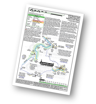
Wye Dale - Blackwell Junction - The Monsal Trail - Chee Dale - Miller's Dale Station - Miller's Dale - Priestcliffe - Taddington - Sough Top - Chelmorton - The Midshires Way - Burrs Farm - Marl Dale - Topley Pike Quarry - Wye Dale
|
Vital Statistics:
| Length: | 9.5 miles (15 km) |
| Ascent: | 1,273ft (388m) |
| Time: | 4.75hrs |
| Grade: | |
Route Summary:
Bakewell - Castle Hill - Ballcross Farm - Edensor - River Derwent - Queen Mary's Bower - The Derwent Valley Heritage Way - Chatsworth Park - Calton Lees - Bank Wood - Rowsley - Bouns Corner - Aaron Hole Plantation - Shadyside Plantation - Haddon Park - River Wye - Wye Valley - Bakewell
|
Vital Statistics:
| Length: | 7.25 miles (11.5 km) |
| Ascent: | 1,388ft (423m) |
| Time: | 4 hrs |
| Grade: | |
Route Summary:
Errwood Reservoir - The Goyt Valley - The Street - Fernilee Reservoir - Jep Clough - Deep Clough - Mill Clough - The Midshires Way - Knife Farm - Madscar Farm - Overton Hall Farm - Taxal Edge - Windgather Rocks - Goyt Forest - Pym Chair - The Street - Foxlow Edge - The Goyt Valley - Errwood Hall - Errwood Reservoir
|
Vital Statistics:
| Length: | 10.25 miles (16.5 km) |
| Ascent: | 1,453ft (443m) |
| Time: | 5.25hrs |
| Grade: | |
Route Summary:
Monyash - The Limestone Way - Dalehouse Farm - Blackwell Lane - Hutmoor Butts - Hardlow - Sparklow - High Wheeldon - Crowdecote (Crowdicote) - Bridge End Farm - Upper Dove Dale - Pilsbury Castle Hills - Vincent House - Darley Farm - Parsley Hay - Moscar Farm - Monyash
|
Vital Statistics:
| Length: | 5 miles (8 km) |
| Ascent: | 485ft (148m) |
| Time: | 2½ hrs |
| Grade: | |
Route Summary:
Longshaw Country Park - Woodcroft Car Park - The Fox House Inn - Sheffield Country Walk - Nell Croft - Totley Moss - Totley Moor - Bar Brook - Lady's Cross (White Edge Moor) - White End Lodge - Wooden Pole - Longshaw Country Park
|
Vital Statistics:
| Length: | 15.25 miles (24.5 km) |
| Ascent: | 1,759ft (536m) |
| Time: | 7.25hrs |
| Grade: | |
Route Summary:
Wye Dale - The River Wye - Blackwell Junction - The Monsal Trail - Chee Dale - Miller's Dale Station - Miller's Dale - Litton Mill - Water-cum-Jolly Dale - Cressbrook - Monsal Dale - White Lodge - Deep Dale - Taddington - Sough Top - Chelmorton - Burrs Farm - Marl Dale - Wye Dale
|
Vital Statistics:
| Length: | 8.75 miles (14 km) |
| Ascent: | 1,703ft (519m) |
| Time: | 5 hrs |
| Grade: | |
Route Summary:
Ashford In The Water - Monsal Head - Upperdale - The River Wye - The Monsal Trail - Monsal Head Viaduct - Monsal Dale - White Lodge - Deep Dale - Sheldon - Ashford In The Water
|
Vital Statistics:
| Length: | 9.75 miles (15.5 km) |
| Ascent: | 1,697ft (517m) |
| Time: | 5.25hrs |
| Grade: | |
Route Summary:
Eyam - Foolow - Eyam Edge - Bretton - Bretton Clough - Abney Clough - Stoke Ford - Mill Wood - Brook Wood - Hazelford - Leam - Eyam Moor - Sir William Hill - Eyam
|
Vital Statistics:
| Length: | 4.75 miles (7.5 km) |
| Ascent: | 230ft (70m) |
| Time: | 2 hrs |
| Grade: | |
Route Summary:
Bakewell - River Wye - Haddon Park - Haddon Hall - Haddon Fields - Wigger Dale - Burton Ashes Wood - Bakewell
|
Vital Statistics:
| Length: | 5.5 miles (8.5 km) |
| Ascent: | 1,007ft (307m) |
| Time: | 3 hrs |
| Grade: | |
Route Summary:
Longshaw Country Park - Woodcroft Car Park - Burbage Brook - Burbage Bridge - Toad's Mouth - Hathersage Moor - Carl Wark - Higger Tor - Upper Burbage Bridge - Burbage Moor - Burbage Rocks - Longshaw Country Park
|
Vital Statistics:
| Length: | 6 miles (9.5 km) |
| Ascent: | 1,310ft (399m) |
| Time: | 3½ hrs |
| Grade: | |
Route Summary:
Errwood Reservoir - The Goyt Valley - Shooter's Clough - Shining Tor - The Tors - Cats Tor - Oldgate Nick - Pym Chair - The Street - Foxlow Edge - The Goyt Valley - Errwood Hall - Errwood Reservoir
|
Vital Statistics:
| Length: | 7.25 miles (12.5 km) |
| Ascent: | 1,056ft (322m) |
| Time: | 3.75hrs |
| Grade: | |
Route Summary:
Tissington - The Tissington Trail - Thorpe Station - Thorpe - Pike House - Thorpe Pasture - Bostern Grange Farm - Alsop en le Dale Station - Tissington
|
Vital Statistics:
| Length: | 5.5 miles (8.5 km) |
| Ascent: | 869ft (265m) |
| Time: | 3 hrs |
| Grade: | |
Route Summary:
Baslow - Over End - Wellington's Monument - Eagle Stone - Eaglestone Flat - Baslow Edge - Curbar - Calver - The Derwent Valley Heritage Way - River Derwent - Bridge End - Baslow
|
Vital Statistics:
| Length: | 3.25 miles (5.5 km) |
| Ascent: | 367ft (112m) |
| Time: | 1½ hrs |
| Grade: | |
Route Summary:
Birchover - Stanton Moor - Cork Stone - Nine Ladies Stone Circle - The Reform Tower (or Earl Grey Tower) - Birchover
|
Vital Statistics:
| Length: | 9.75 miles (15.5 km) |
| Ascent: | 1,522ft (464m) |
| Time: | 5 hrs |
| Grade: | |
Route Summary:
Sheldon - High Low - Nursery Field Farm - Monyash - Riklow Dale - Lathkill Dale - Cales Dale - Low Wood - Calling Low Dale - Palmerston Wood - Meadow Place Grange - Twin Dales - Lathkill Lodge - Over Haddon - Bole Hill (Bakewell) - Kirk Dale - Magpie Mine - Sheldon
|
Vital Statistics:
| Length: | 9.5 miles (15 km) |
| Ascent: | 1,696ft (517m) |
| Time: | 5.25hrs |
| Grade: | |
Route Summary:
Youlgreave - The Limestone Way - Bradford Dale - Moatlow Knob - River Bradford - Rusden Wood - Gratton Moor - Long Dale - Gratton Dale - Dale End (Elton) - Elton - Anthony Hill - Longshawe Wood - Bleakley Plantation - Mawstone Farm - Bradford Dale - River Bradford - Youlgreave
|
Vital Statistics:
| Length: | 5.75 miles (9 km) |
| Ascent: | 890ft (271m) |
| Time: | 3 hrs |
| Grade: | |
Route Summary:
Baslow - Bar Brook - The Cannon Kissing Gate - Chatsworth Park - Jubilee Rock - Jumble Coppice - Heathy Lea Brook - Robin Hood (Baslow) - Birchen Edge Car Park - Three Ships - Nelson's Monument (Birchen Edge) - Birchen Edge - Eaglestone Flat - Wellington's Monument - Eagle Stone - Over End - Baslow
|
Vital Statistics:
| Length: | 8.5 miles (13.5 km) |
| Ascent: | 896ft (273m) |
| Time: | 4 hrs |
| Grade: | |
Route Summary:
Longshaw Country Park - Woodcroft Car Park - Wooden Pole - White Edge Moor - White Edge (Big Moor) - White Edge (Big Moor) (South East Top) - Curbar Gap - Curbar Edge - Froggatt Edge - Hay Wood - Longshaw Estate - Sheffield Plantation - Longshaw Lodge - Longshaw Country Park
|
Vital Statistics:
| Length: | 11.75 miles (19 km) |
| Ascent: | 1,989ft (606m) |
| Time: | 6.25hrs |
| Grade: | |
Route Summary:
Eyam - The Cliff - Stoney Middleton - Coombs Dale - Sallet Hole Mine - Rough Side - Black Harry Gate - Blakedon Hollow - High Rake - Longstone Edge - Watershaw Rake - Longstone Moor - Wardlow Hay Cop - Cressbrook Dale - Tansley Dale - Wardlow Mires - Stanley House Farm - Silly Dale - Foolow - Linen Dale - Eyam
|
Vital Statistics:
| Length: | 7.5 miles (12 km) |
| Ascent: | 1,257ft (383m) |
| Time: | 4 hrs |
| Grade: | |
Route Summary:
Baslow - Baslow Nether End - Baslow Over End - Gorse Bank Farm - Grislow Field Farm - Lane Farm - Curbar - The Derwent Valley Heritage Way - The River Derwent - Stocking Farm - The Goit - New Bridge - Stoke Brook - Froggatt Bridge - Froggatt - Curbar Edge - Curbar Gap - Baslow Edge - Eagle Stone - Wellington's Monument - Baslow
|
Vital Statistics:
| Length: | 5 miles (8 km) |
| Ascent: | 607ft (185m) |
| Time: | 2½ hrs |
| Grade: | |
Route Summary:
Chatsworth House - Stand Wood Ornamental Waterfall - Chatsworth Elizabethan Hunting Tower - Dobb Edge - Robin Hood (Baslow) - Birchen Edge Car Park - Jumble Coppice - Jubilee Rock - Chatsworth Park - The Cannon Kissing Gate - Baslow - The Derwent Valley Heritage Way - Chatsworth House
|
Vital Statistics:
| Length: | 8.75 miles (14 km) |
| Ascent: | 1,171ft (357m) |
| Time: | 4½ hrs |
| Grade: | |
Route Summary:
Hartington - Gorsecroft - Madge Dale - Bank Top Farm - Carder Low - Vincent House - Darley Farm - The High Peak Trail - Parsley Hay - The Tissington Trail - Hartington Station - Heathcote - Heathcote Mere - Highfield Lane - Hartington
|
Vital Statistics:
| Length: | 12.75 miles (20.5 km) |
| Ascent: | 1,956ft (596m) |
| Time: | 6.75hrs |
| Grade: | |
Route Summary:
Darley Bridge - Wensley Dale - Northern Dale - Ash Plantation - Brightgate Farm - Bonsall Moor - The Limestone Way - Luntor Rocks - Winster - Westhill Farm - Robin Hood's Stride - Harthill Moor - Harthill Moor Wood - Bleakley Dike - River Bradford - Bradford Dale - Youlgreave - Rhienstor Plantation - Greenfield Farm - Stoney Ley Wood - Rocking Stone Farm - Birchover - Uppertown Farm - Clough Wood - Sabine Hey Wood - Cowley Knowl - Darley Bridge
|
Vital Statistics:
| Length: | 5 miles (8 km) |
| Ascent: | 433ft (132m) |
| Time: | 2 hrs |
| Grade: | |
Route Summary:
Minninglow - The High Peak Trail - Green Lane - Cobblersnook Lane - Minninglow Lane - The High Peak Trail - Minninglow
|
Vital Statistics:
| Length: | 5.5 miles (8.5 km) |
| Ascent: | 847ft (258m) |
| Time: | 2.75hrs |
| Grade: | |
Route Summary:
Calton Lees - River Derwent - Beeley Lodge - Beeley Hilltop Farm - Rounds - Beeley Brook - Hell Bank Plantation - Beeley Plantation - Smeltingmill Wood - Burntwood Quarry - Fold Farm - Beeley - River Derwent - Calton Lees
|
Vital Statistics:
| Length: | 8.25 miles (13 km) |
| Ascent: | 1,430ft (436m) |
| Time: | 4½ hrs |
| Grade: | |
Route Summary:
Hartington - Crossland Sides - Pennilow - Beresford Dale - Pike Pool - How Narrowdale - The Rakes - Alstonefield - Overdale - Gipsy Bank - River Dove - Coldeaton Bridge - Iron Tors - Drabber Tor - Wolfscote Dale - Peasland Rocks - Staden Barn - Hartington
|
Vital Statistics:
| Length: | 8.75 miles (14 km) |
| Ascent: | 1,342ft (409m) |
| Time: | 4½ hrs |
| Grade: | |
Route Summary:
Winster - The Limestone Way - Westhill Farm - Robin Hood's Stride - Harthill Moor - Harthill Moor Wood - Bleakley Dike - River Bradford - Bradford Dale - Youlgreave - Mawstone Farm - Bleakley Plantation - Longshawe Wood - Anthony Hill - Elton - Sacheveral Farm - Winster
|
Vital Statistics:
| Length: | 4 miles (6.5 km) |
| Ascent: | 508ft (155m) |
| Time: | 2 hrs |
| Grade: | |
Route Summary:
Fenny Bentley - Lees Farm - Darfield Plantation - Tissington - The Tissington Trail - Thorpe Station - Fenny Bentley
|
Vital Statistics:
| Length: | 9 miles (14.5 km) |
| Ascent: | 1,257ft (383m) |
| Time: | 5 hrs |
| Grade: | |
Route Summary:
Bakewell - River Wye - Haddon Park - Shadyside Plantation - Aaron Hole Plantation - Bouns Corner - Rowsley - Congreave Farm - Smithy Wood - Stanton In The Peak - Tolls Wood - Shiningbank Quarry - Haddon Fields - Wigger Dale - Burton Ashes Wood - Bakewell
|
Vital Statistics:
| Length: | 6.25 miles (10 km) |
| Ascent: | 1,224ft (373m) |
| Time: | 3½ hrs |
| Grade: | |

Route Summary:
Hartington - Crossland Sides - Pennilow - Beresford Dale - Pike Pool - Wolfscote Dale - River Dove - Peasland Rocks - Biggin Dale - Furny Bottom - Dale End - Biggin - Hartington
|
Vital Statistics:
| Length: | 4.5 miles (7 km) |
| Ascent: | 551ft (168m) |
| Time: | 2.25hrs |
| Grade: | |
|
Vital Statistics:
| Length: | 6.5 miles (10.5 km) |
| Ascent: | 1,129ft (344m) |
| Time: | 3½ hrs |
| Grade: | |
Route Summary:
Hartington - Bridge End - Harris Close - High Close - Upper Dove Dale - Pilsbury - Pilsbury Castle Hills - Carder Low - Bank Top Farm - Madge Dale - Hartington
|
Vital Statistics:
| Length: | 5.75 miles (9 km) |
| Ascent: | 1,217ft (371m) |
| Time: | 3.25hrs |
| Grade: | |
Route Summary:
Winster - Upper Town - Clough Wood - Sabine Hay Wood - Cowley Knowl - Cambridge Wood - Wensley - Big Dungeon - Wensley Dale - Northern Dale - Brightgate Farm - The Limestone Way - Luntor Rocks - Winster
|
Vital Statistics:
| Length: | 4.75 miles (7.5 km) |
| Ascent: | 791ft (241m) |
| Time: | 2½ hrs |
| Grade: | |
Route Summary:
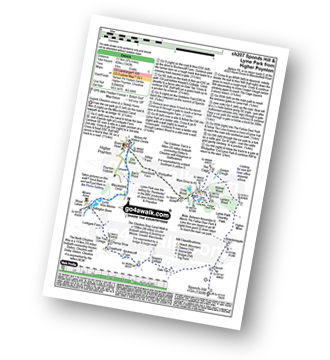
Great Longstone - Longstone Edge - High Rake - Watershaw Rake - Longstone Moor - Little Longstone - Monsal Head - Great Longstone
|
Vital Statistics:
| Length: | 7.25 miles (11.5 km) |
| Ascent: | 1,657ft (505m) |
| Time: | 4.25hrs |
| Grade: | |
Route Summary:
Earl Sterndale - Glutton Grange - Hatch-a-way - Dowel Dale - Owl Hole - Greensides Farm - Stoop Farm - Booth Farm - Leycote Farm - Packhorse Bridge - Moorside Farm - Hollinsclough - Swallow Brook - Parkhouse Hill - Hitter Hill - Earl Sterndale
|
Vital Statistics:
| Length: | 8.25 miles (13 km) |
| Ascent: | 1,588ft (484m) |
| Time: | 4½ hrs |
| Grade: | |
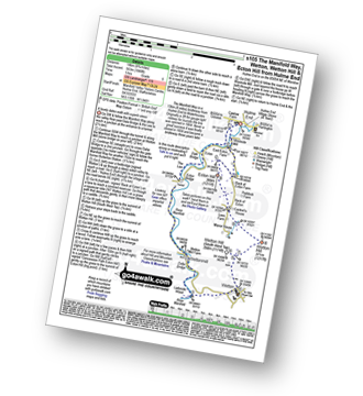
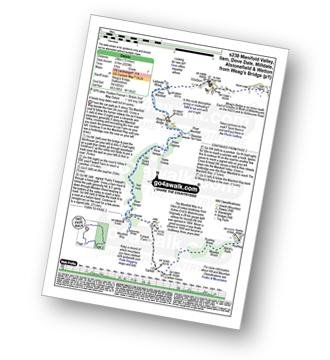
Route Summary:
Waterhouses - The Manifold Way - The River Hamps - Sparrowlee Bridge - Lee House - Hell Hole - Old Soles Wood - Soles Coppice - The River Manifold - Weag's Bridge - Beeston Tor Farm - Throwley Hall Farm - Throwley Cottage - Farwall Farm - The Manifold Way - Waterhouses
|
Vital Statistics:
| Length: | 5 miles (8 km) |
| Ascent: | 640ft (195m) |
| Time: | 2½ hrs |
| Grade: | |
Route Summary:
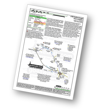
Longnor - The Manifold Trail - River Manifold - Lower Boothfold Farm - Ludburn Farm - Bridge End - The Ferns Farm - Heath House - Longnor
|
Vital Statistics:
| Length: | 6.25 miles (10 km) |
| Ascent: | 623ft (190m) |
| Time: | 3 hrs |
| Grade: | |
Route Summary:
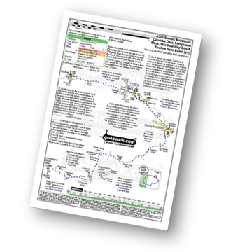
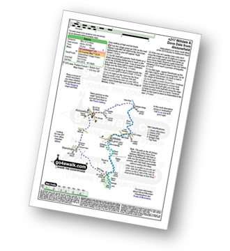
Dove Dale - The River Dove - Stepping Stones - Lover's Leap - Tissington Spires - Shaplow Dale,Natural Arch - Raynard's Cave - Upper Taylor's Wood - Dove Holes - Viator's Bridge - Milldale - Achas Bank - Hall Dale - Hurt's Wood - Ilam Rock - Jacob's Ladder (Dove Dale) - Dove Dale Wood - Dovedale Castle - Dove Dale
|
Vital Statistics:
| Length: | 3.75 miles (6 km) |
| Ascent: | 775ft (236m) |
| Time: | 2.25hrs |
| Grade: | |
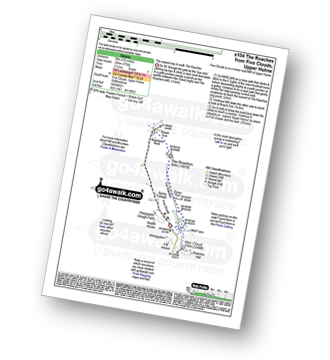
Route Summary:
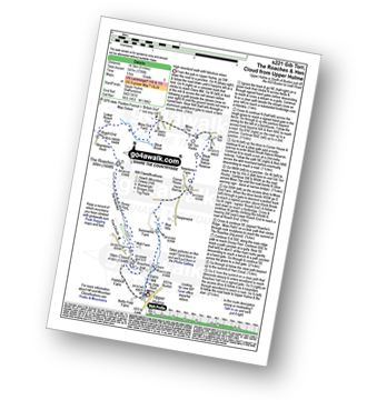
Five Clouds - Upper Hulme - Rockhall - Doxey Pool - The Roaches - Roach End - Spring Cottage - Five Clouds - Upper Hulme
|
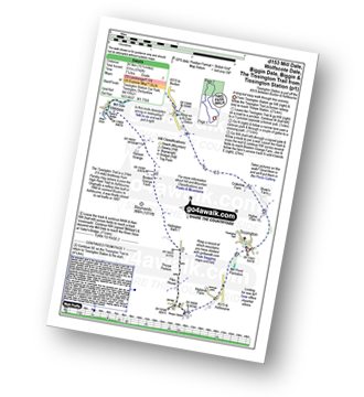
Vital Statistics:
| Length: | 8.75 miles (14 km) |
| Ascent: | 1,848ft (563m) |
| Time: | 5 hrs |
| Grade: | |
Route Summary:
Hulme End - Manifold Valley Visitors Centre - The Manifold Way - Dale Bridge - The Lee - Tunnel - River Manifold - Wetton Mill Farm - Wettonmill - Dafar Bridge - Ladyside Wood - Wetton - Wetton Hill (South West Top) - Wetton Hill - Cantrell's House - Ecton Hill - Westside Mill - The Manifold Way - Hulme End
|
Vital Statistics:
| Length: | 6 miles (9.5 km) |
| Ascent: | 1,237ft (377m) |
| Time: | 3½ hrs |
| Grade: | |
Route Summary:
Hollinsclough - Swallow Brook - Parkhouse Hill - Chrome Hill - Stoop Farm - High Edge - Booth Farm - Hollins Hill - Hollinsclough
|
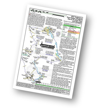
Vital Statistics:
| Length: | 8.25 miles (13 km) |
| Ascent: | 1,464ft (446m) |
| Time: | 4½ hrs |
| Grade: | |
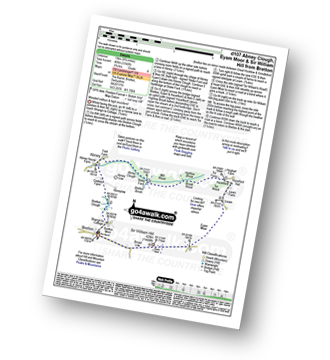
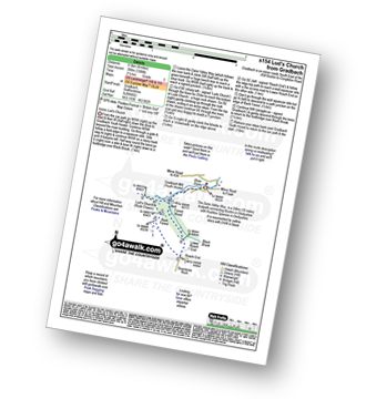
Route Summary:
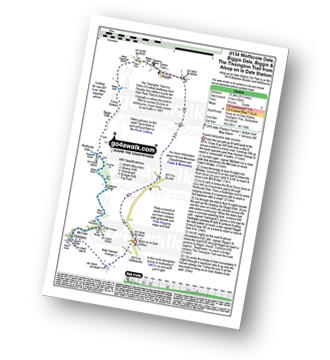
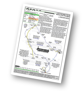
Gradbach - The Dane Valley Way - River Dane - Dane View House - Three Shires Head - Panniers Pool - Knotbury Farm - Wolf Edge - Oliver Hill - Flash - Lower House Farm - Flash Brook Farm - Ann Roach Rocks - Gib Torr Rocks - Moss Top - Cloughhead - Gradbach
|
Vital Statistics:
| Length: | 7.75 miles (12.5 km) |
| Ascent: | 1,139ft (347m) |
| Time: | 4 hrs |
| Grade: | |
Route Summary:
Onecote - Hamps Way - Onecote Grange - The River Hamps - Mixon Mines - Black Brook Farm - Breech Farm - Under The Hill Farm - Upper Elkstone - Ryecroft Farm - Hole Farm - Hill Farm - Butterton - The Twist - Grindon Moor (Grindon Moor) - Home Farm - Onecote
|
Vital Statistics:
| Length: | 9.75 miles (15.5 km) |
| Ascent: | 2,146ft (654m) |
| Time: | 5.75hrs |
| Grade: | |
Route Summary:
Ilam - Ilam Country Park - River Manifold - Castern Hall - Castern Wood Nature Reserve - Wetton Low - Wetton - Alstonefield - Milldale - Achas Bank - Raven's Tor - Hall Dale - Dove Dale Wood - Air Cottage - Ilam Tops - Ilamtops Farm - Ilam
|
Vital Statistics:
| Length: | 8.25 miles (13 km) |
| Ascent: | 689ft (210m) |
| Time: | 3.75hrs |
| Grade: | |
Route Summary:
Milldale - Dove Dale - Viator's Bridge - River Dove - Dove Holes - Upper Taylor's Wood - Pickering Tor,Raynard's Cave - Natural Arch - Sharplow Dale - Jacob's Ladder (Dove Dale) - Lover's Leap - Twelve Apostles - Dove Dale Castle - Thorpe Cloud - Ilam - Ilam Country Park - St Bartram's Bridge - River Manifold - Battle Stone Cross - Ilam Wood - River Lodge - Castern Hall - Castern Farm - Stanshope - Milldale
|
Vital Statistics:
| Length: | 9.75 miles (15.5 km) |
| Ascent: | 1,910ft (582m) |
| Time: | 5½ hrs |
| Grade: | |
Route Summary:
Alstonefield - Milldale - Mill Dale - Lode Mill Bridge - River Dove - Coldeaton Bridge - Iron Tors - Gipsy Bank - Drabber Tor - Caves - Peasland Tor - Wolfscote Dale - Frank-i-th-Rocks Bridge - Wolfscote Grange - Wolfscote Hill - Beresford Dale - Narrowdale Hill - Narrow Dale - Gratton Hill - The Rakes - Alstonefield
|
Vital Statistics:
| Length: | 3.75 miles (6 km) |
| Ascent: | 289ft (88m) |
| Time: | 1.75hrs |
| Grade: | |
Route Summary:
Hulme End - Manifold Valley Visitors Centre - Lowend - Low End Farm - Buttsend - Brund - The Manifold Way - The River Manifold - Brund Mill - Holme House - Hulme End
|
Vital Statistics:
| Length: | 11.5 miles (18.5 km) |
| Ascent: | 2,274ft (693m) |
| Time: | 6½ hrs |
| Grade: | |
Route Summary:
Gradbach - The Dane Valley Way - Gradbach Youth Hostel - Black Brook - Forest Wood - Roach End - The Roaches - Doxey Pool - Rockhall - Hen Cloud - Well Farm - Dains Mill - Upper Hulme - Butty Fold Farm - Staffordshire Moorlands Walk - Tittesworth Reservoir - Meerbrook - Stockmeadows Farm - Meadows Farm - Buxton Brow - Clough Head - Back Forest - Lud's Church - Rock Chasm - Black Brook - Gradbach Youth Hostel - The Dane Valley Way - Gradbach
|
Vital Statistics:
| Length: | 4 miles (6.5 km) |
| Ascent: | 942ft (287m) |
| Time: | 2½ hrs |
| Grade: | |
Route Summary:
Flash - Oliver Hill - Knotbury Farm - Panniers Pool - Three Shires Head - The Dane Valley Way - River Dane - Wicken Walls Farm - Axe Edge Green Farm - Flash
|
Vital Statistics:
| Length: | 3.25 miles (5 km) |
| Ascent: | 778ft (237m) |
| Time: | 2 hrs |
| Grade: | |
Route Summary:
Roach End - Back Forest - Forest Wood - Lud's Church - Roach End - The Roaches - Roach End
|
Vital Statistics:
| Length: | 9 miles (14.5 km) |
| Ascent: | 1,178ft (359m) |
| Time: | 4½ hrs |
| Grade: | |
Route Summary:
Abbey Green - Abbey Wood - Hillswood - North Hillswood Farm - Tittesworth Reservoir - Meerbrook - Lea End - Stockmeadows Farm - Meadows Farm - Turner's Pool - Old Hag Farm - Gun (Staffordshire) - Fould Farm - Abbey Green
|
Vital Statistics:
| Length: | 7.25 miles (11.5 km) |
| Ascent: | 1,302ft (397m) |
| Time: | 4 hrs |
| Grade: | |
Route Summary:
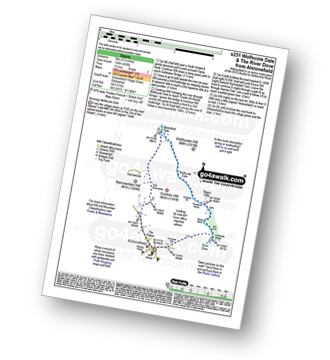
Milldale - River Dove - Alstonefield - Wetton - Wetton Low - Castern Wood Nature Reserve - Damgate Farm - Hall Dale - Dove Dale - Achas Bank - Milldale
|
Vital Statistics:
| Length: | 5 miles (8 km) |
| Ascent: | 1,306ft (398m) |
| Time: | 3.25hrs |
| Grade: | |
Route Summary:
Gradbach - The Dane Valley Way - Gradbach Youth Hostel - The River Dane - Black Brook - Forest Wood - Lud's Church - Back Forest - Roach End - The Roaches - Roach End - Forest Wood - Black Brook - The River Dane - Gradbach Youth Hostel - The Dane Valley Way - Gradbach
|
Vital Statistics:
| Length: | 6 miles (9.5 km) |
| Ascent: | 1,034ft (315m) |
| Time: | 3.25hrs |
| Grade: | |
Route Summary:
Hulme End - Manifold Valley Visitors Centre - The Manifold Way - Dale Bridge - The Lee - Tunnel - River Manifold - Wetton Mill Farm - Wettonmill - Dale Farm - Sugarloaf (Wetton) - Broad Ecton Farm - Ecton Hill - Westside Mill - The Manifold Way - Hulme End
|
Vital Statistics:
| Length: | 8.5 miles (13.5 km) |
| Ascent: | 1,523ft (464m) |
| Time: | 4.75hrs |
| Grade: | |
Route Summary:
Butterton - Revidge - Cuckoostones - Reaps Moor - Blake Brook - Little Fernyfold Farm - Herbage Barn - Lum Edge - Upper Elkstone - Ryecroft Farm - Hole Farm - Hill Farm - Butterton
|
Vital Statistics:
| Length: | 4.75 miles (7.5 km) |
| Ascent: | 659ft (201m) |
| Time: | 2½ hrs |
| Grade: | |
Route Summary:
Longnor - Beggar's Bridge - River Dove - Crowdecote (Crowdicote) - Bridge End Farm - Under Wwhitle Farm - Over Boothlow Farm - The Manifold Trail - River Manifold - Longnor.
|
Vital Statistics:
| Length: | 4 miles (6.5 km) |
| Ascent: | 1,306ft (398m) |
| Time: | 2½ hrs |
| Grade: | |
Route Summary:
Gradbach - The Dane Valley Way - Gradbach Youth Hostel - The River Dane - Black Brook - Forest Wood - Lud's Church - Back Forest - Roach End - Forest Wood - Black Brook - The River Dane - Gradbach Youth Hostel - The Dane Valley Way - Gradbach
|
Vital Statistics:
| Length: | 5 miles (8 km) |
| Ascent: | 991ft (302m) |
| Time: | 2.75hrs |
| Grade: | |
Route Summary:
Flash - Oliver Hill - Oxensitch - River Manifold Head - River Dove - Nether Colshaw Farm - Golling Gate Farm - Dun Cow's Grove Farm - The Manifold Trail - Blackbank Farm - Flash
|
Vital Statistics:
| Length: | 11.5 miles (18.5 km) |
| Ascent: | 1,572ft (479m) |
| Time: | 5.75hrs |
| Grade: | |
Route Summary:
Milldale - Mill Dale - River Dove - Coldeaton Bridge - Gipsy Bank - Peasland Rocks - Wolfscote Dale - Frank-i-the=Ricks Bridge - Beresford Dale - Barracks Farm - Harecops - Acton Moor - Back of Ecton - Ecton Hill - Cantrell's House - Wetton Hill - Wetton Hill (West Top) - Wetton - Alstonefield - Milldale
|
Vital Statistics:
| Length: | 6 miles (9.5 km) |
| Ascent: | 1,234ft (376m) |
| Time: | 3½ hrs |
| Grade: | |
Route Summary:
Five Clouds - Upper Hulme - Rockhall - The Roaches - Roach End - Back Forest - Lud's Church - Rock Chasm - Forest Wood - Roach End - Spring Cottage - Five Clouds - Upper Hulme
|
Vital Statistics:
| Length: | 4.5 miles (7 km) |
| Ascent: | 623ft (190m) |
| Time: | 2.25hrs |
| Grade: | |
Route Summary:
Wetton - River Manifold - Wettonmill - The Manifold Way - Thor's Cave - Manor House - Wetton
|
Vital Statistics:
| Length: | 9.5 miles (15 km) |
| Ascent: | 1,483ft (452m) |
| Time: | 5 hrs |
| Grade: | |
Route Summary:
Warslow - Villa Farm - Clayton House - Wallacre - Hoo Brook - Butterton - The Twist - Grindon Moor (Grindon Moor) - Onecote - Butterton Moor End Farm - Butterton Moor - Golden Hill - Black Brook Farm - Breech Farm - Underhill Farm - Upper Elkstone - Moorside - Cowhay Head - Warslow
|
Vital Statistics:
| Length: | 6.5 miles (10.5 km) |
| Ascent: | 689ft (210m) |
| Time: | 3.25hrs |
| Grade: | |
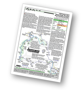
Route Summary:
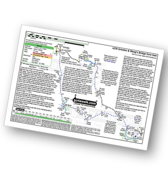
Weag's Bridge - River Manifold - The Manifold Way - River Hamps - Lee House Farm - Farwell Farm - Calton - Slade House - Throwley Moor - Soles Hollow - The Manifold Way - River Manifold - Weag's Bridge
|
Vital Statistics:
| Length: | 6 miles (9.5 km) |
| Ascent: | 715ft (218m) |
| Time: | 3 hrs |
| Grade: | |
Route Summary:
Meerbrook - Lea End - Stockmeadows Farm - Meadows Farm - Turner's Pool - Old Hag Farm - Gun (Staffordshire) - Meerbrook
|
Vital Statistics:
| Length: | 4.75 miles (7.5 km) |
| Ascent: | 1,182ft (360m) |
| Time: | 3 hrs |
| Grade: | |
Route Summary:
Five Clouds - Pheasants Clough Farm - Roach Grange - Roach End - Bearstone Rock - The Roaches - Doxey Pool - Rockhall - Hen Cloud - Rockhall - Five Clouds
|
Vital Statistics:
| Length: | 6.75 miles (11 km) |
| Ascent: | 623ft (190m) |
| Time: | 3.25hrs |
| Grade: | |
Route Summary:
Milldale - Dove Dale - Viator's Bridge - River Dove - Dove Holes - Upper Taylor's Wood - Pickering Tor,Raynard's Cave - Natural Arch - Sharplow Dale - Jacob's Ladder (Dove Dale) - Lover's Leap - Twelve Apostles - Dove Dale Castle - Thorpe Cloud - Ilam - Ilamtops Farm - Ilam Tops - Ilam Rock - Hall Dale - Raven's Tor - Achas Bank - Milldale
|
Vital Statistics:
| Length: | 11.5 miles (18.5 km) |
| Ascent: | 1,487ft (453m) |
| Time: | 2.75hrs |
| Grade: | |
Route Summary:
Longnor - The Manifold Trail - Gauledge Farm - Fawside Farm - The River Manifold - Hardings Booth - Shining Ford - Holly Grove Farm - Newtown - Lady Edge - Round Knowl - Noon Sun Farm - Blake Mere (Merryton Low) - Blake Brook - Lower Fleetgreen Farm - Little Fernyford Farm - The Manifold Trail - Brund Mill - Pool Farm - Lower Boothlow Farm - Over Boothlow Farm - Folds End Farm - Longnor
|
Vital Statistics:
| Length: | 7 miles (11 km) |
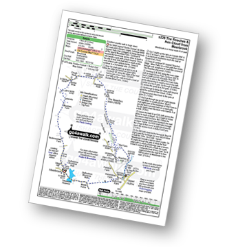
| Ascent: | 1,090ft (332m) |
| Time: | 3.75hrs |
| Grade: | |
Route Summary:
Longnor - The Manifold Trail - Gauledge Farm - Fawside Farm - The River Manifold - Hardings Booth - Hollinsclough Moor - Hollinsclough - Swallow Brook - Earl Sterndale - Abbotside Farm - Green Lane - Beaggar's Bridge - Longnor
|
Vital Statistics:
| Length: | 4.75 miles (7.5 km) |
| Ascent: | 754ft (230m) |
| Time: | 2½ hrs |
| Grade: | |
Route Summary:
Ilam - Ilam Country Park - River Manifold - Lower Dove Dale - Upper Musden - Hazelton Clump - Blore - Coldwall Farm - The Limestone Way - Coldwall Bridge - The Manifold Trail - River Dove - Fishpond Wood - River Manifold - Ilam
|
Vital Statistics:
| Length: | 4.75 miles (7.5 km) |
| Ascent: | 909ft (277m) |
| Time: | 3 hrs |
| Grade: | |
Route Summary:
Grindon - Weag's Bridge - The Manifold Way - Thor's Cave - Wettonmill - Hoo Brook - Grindon
|
Vital Statistics:
| Length: | 11.5 miles (18.5 km) |
| Ascent: | 1,897ft (578m) |
| Time: | 6.25hrs |
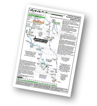
| Grade: | |
Route Summary:
Gradbach - Bradley Howel - Little Hillend - Ann Roach Farm - Adder's Green - Morridge Top - Penthills Farm - Smallshaw Farm - High Ash - Bradshaw Farm - Bottom Hocker - Oakenclough Hall - Oakenclough Brook - Boarsgrove Farm - Middle Hills - Morridge - Royal Cottage - Blackbank Farm - Goldsitch Farm - Black Brook - Cloughhead - Gradbach
|
Vital Statistics:
| Length: | 4.5 miles (7 km) |
| Ascent: | 538ft (164m) |
| Time: | 2.25hrs |
| Grade: | |
Route Summary:
Longnor - The Manifold Trail - Moss Carr Farm - Hollinsclough - Swallow Brook - Yewtree Grange - Under The Hill - Longnor
|
Vital Statistics:
| Length: | 8.75 miles (14 km) |
| Ascent: | 1,690ft (515m) |
| Time: | 5 hrs |
| Grade: | |
Route Summary:
Butterton - Grindon Moor (Grindon Moor) - Ford - Ryebrook Farm - Grindon - Weag's Bridge - The Manifold Way - The River Manifold - Thor's Cave - Ladyside Wood - Dafar Bridge - Wettonmill - Hoo Brook - Butterton
|
Vital Statistics:
| Length: | 14.5 miles (23.5 km) |
| Ascent: | 3,049ft (929m) |
| Time: | 8½ hrs |
| Grade: | |
Route Summary:
Longnor - The Manifold Trail - Gauledge Farm - Fawside Farm - The River Manifold - Hardings Booth - Ball Bank Farm - The River Manifold - Heathylee House - Hollinsclough Moor - Wilshaw Bottom - Wilshaw Farm - Moorside Farm - Hollinsclough - Hollins Farm - Swallow Brook - Parkhouse Hill - Hitter Hill - Earl Sterndale - Abbots Grove - Wheeldon Trees - High Wheeldon - Crowdecote - Bridge End Farm - Pilsbury Castle Hills - Pilsbury - Sheen Lane Farm - Ridge End Farm - The Manifold Trail - Lower Boothlow Farm - Folds End Farm - Longnor
|
Vital Statistics:
| Length: | 7.5 miles (12 km) |
| Ascent: | 811ft (247m) |
| Time: | 3½ hrs |
| Grade: | |
Route Summary:
Longnor - The Manifold Trail - River Manifold - Lower Boothfold Farm - Ludburn Farm - Reaps Moor - Blake Brook - Boosley Grange - Bank House Farm - Shining Ford Farm - Hardings Booth Farm - Fawside Farm - Gualedge Farm - Longnor
|
Vital Statistics:
| Length: | 10 miles (16 km) |
| Ascent: | 1,953ft (595m) |
| Time: | 5.75hrs |
| Grade: | |
Route Summary:
Flash - Oliver Hill - Oxensitch - River Manifold Head - River Dove - Nether Colshaw Farm - Golling Gate Farm - Dun Cow's Grove Farm - The Manifold Trail - Blackbank Farm - Wilson Knowl Farm - Lower House Farm - Culvert Farm - Tollbridge Cottage - Gradbach - The Dane Valley Way - Dane View House - River Dane - Three Shires Head - Panniers Pool - Knotbury Farm - Wolf Edge - Flash
|
Vital Statistics:
| Length: | 6 miles (9.5 km) |
| Ascent: | 918ft (280m) |
| Time: | 3.25hrs |
| Grade: | |
Route Summary:
Swinscoe - Hillend Farm - Feenie Lee - Blore - The Limestone Way - Coldwall Bridge - River Dove - Big Peg's Wood - Little Peg's Wood - Littlepark Farm - Mappleton (aka Mapleton) - Okeover Hall - Okeover Park - Cowclose Wood - Martin Hill - Woodhouse Farm - Swinscoe
|
Vital Statistics:
| Length: | 4.5 miles (7 km) |
| Ascent: | 834ft (254m) |
| Time: | 2½ hrs |
| Grade: | |
Route Summary:
Longnor - River Dove - Beggar's Bridge - High Wheeldon - Abbotside Farm - Earl Sterndale - Hitter Hill - Parkhouse Hill - High Acres - Yewtree Grange - Underhill Farm - Longnor
|
Vital Statistics:
| Length: | 11.5 miles (18 km) |
| Ascent: | 1,267ft (386m) |
| Time: | 5½ hrs |
| Grade: | |
Route Summary:
Waterhouses - Waterfall Cross - Martins Low - River Hamps - Ford - Onecote - Grindonmoor Gate - Grindon Moor (Grindon Moor) - Grindon - Lee House - The Manifold Way - Waterhouses
|
Vital Statistics:
| Length: | 5.5 miles (9 km) |
| Ascent: | 1,615ft (492m) |
| Time: | 3.75hrs |
| Grade: | |
Route Summary:
Alstonefield - Alstonefield Youth Hostel - Overdale - Gipsy Bank - Wolfescote Dale - Coldeaton Bridge - Mill Dale - Milldale - Dove Dale - Achas Bank - Ilam Rock - Dovedale - Hall Dale - Stanshope - Dale Bottome - Alstonefield.
|
Vital Statistics:
| Length: | 9 miles (14.5 km) |
| Ascent: | 1,795ft (547m) |
| Time: | 5 hrs |
| Grade: | |
Route Summary:
Upper Hulme - Dains Mill - Blue Hills - Black Brook Nature Reserve - Gib Torr Rocks - Moss Top - Moss End Farm - Black Brook - Roach End - The Roaches - Rockhall - Hen Cloud - Roaches Hall - Upper Hulme
|
Vital Statistics:
| Length: | 6.5 miles (10.5 km) |
| Ascent: | 745ft (227m) |
| Time: | 3.25hrs |
| Grade: | |
Route Summary:
Mappleton (aka Mapleton) - Okeover Bridge - Okeover Hall - Okeover Park - Cowclose Wood - Martin Hill Farm - Woodhouses Farm - Blore - Blore Pastures - Ilam - River Manifold - The Manifold Trail - Fishpond Wood - River Dove - Coldwall Bridge - Big Peg's Wood - Little Peg's Wood - Littlepark Farm - Okeover Bridge - Mappleton (aka Mapleton)
|
Vital Statistics:
| Length: | 8.25 miles (13 km) |
| Ascent: | 1,490ft (454m) |
| Time: | 4½ hrs |
| Grade: | |
Route Summary:
Meerbrook - Lea End - Stockmeadows Farm - Meadows Farm - Buxton Brow Farm - Clough Head - Roach End - Bearstone Rock - The Roaches - Doxey Pool - Rockhall - Hen Cloud - Rockhall - Well Farm - Dains Mill - Upper Hulme - Butty Fold Farm - Tittesworth Reservoir - Meerbrook
|
Vital Statistics:
| Length: | 10.25 miles (16.5 km) |
| Ascent: | 1,969ft (600m) |
| Time: | 2.75hrs |
| Grade: | |
Route Summary:
Ilam - The Manifold Trail - Ilam Country Park - River Manifold - Rushley - Slade House - Throwley Moor - Lee House Farm - Manifold Valley - River Hamps - Saucefield Farm - Grindon - Weag's Bridge - Beeston Tor Farm - The Manifold Trail - Throwley Hall Farm - Rushley - Ilam Country Park - Ilam
|
Vital Statistics:
| Length: | 5.5 miles (9 km) |
| Ascent: | 426ft (130m) |
| Time: | 2½ hrs |
| Grade: | |
Route Summary:
Alstonefield - Overdale - Coldeaton Bridge - River Dove - Coldeaton Bridge - Iron Tors - Gipsy Bank - Drabber Tor - Caves - Peasland Tor - Wolfscote Dale - Beresford Dale - Narrow Dale - The Rakes - Alstonefield
|
Vital Statistics:
| Length: | 9.25 miles (15 km) |
| Ascent: | 1,769ft (539m) |
| Time: | 5.25hrs |
| Grade: | |
Route Summary:
Alstonefield - Dale Bottom - Hopedale - Castern Wood Nature Reserve - Wetton Low - Wetton - Wetton Hill (West Top) - Wetton Hill - Ecton Hill - Acton Moor - Gateham Grange - Gateham Farm - Steep Low - Alstonefield
|
Vital Statistics:
| Length: | 11 miles (17.5 km) |
| Ascent: | 1,342ft (409m) |
| Time: | 5.25hrs |
| Grade: | |
Route Summary:
Longnor - River Manifold - The Manifold Trail - Over Boothlow Farm - Lower Boothlow Farm - Hill End Farm - Sheen Hill - Slate House Farm - Sheen - Brund - River Manifold - Brund Mill - New Road Farm - Field House Farm - Reaps Moor - Black Brook - Smedley Sytch - Boosley Grange - Fawfield Head - Bank House - Shining Ford - The Manifold Trail - Hardings Booth - Fawside Farm - Gauledge Farm,Longnor.
|
Vital Statistics:
| Length: | 15 miles (24 km) |
| Ascent: | 2,028ft (618m) |
| Time: | 8 hrs |
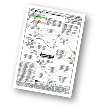
| Grade: | |
Route Summary:
Weag's Bridge - River Manifold - Beeston Tor Farm - River Hamps - Soles Coppice - Old Soles Wood - Hell Hole - Lee House - Farwell Farm - Calton - Carlton Green - Rushley Wood - Musden Wood - Rushley - Ilam Country Park - Ilam - River Dove - Dovedale Castle - Dove Dale - The River Dove - Stepping Stones - Lover's Leap - Tissington Spires - Shaplow Dale,Natural Arch - Raynard's Cave - Upper Taylor's Wood - Dove Holes - Viator's Bridge - Milldale - Alstonefield - Wetton - Thor's Cave - Weag's Bridge
|
Vital Statistics:
| Length: | 10.25 miles (16.5 km) |
| Ascent: | 1,486ft (453m) |
| Time: | 5.25hrs |
| Grade: | |
Route Summary:
Ilam - The Manifold Trail - Ilam Country Park - River Manifold - Castern Hall - Castern Wood Nature Reserve - Weag's Bridge - The Manifold Way - The River Hamps - Manifold Valley - Lee House Farm - Throwley Moor - Slade House - Rushley - Ilam Country Park - Ilam
|
Vital Statistics:
| Length: | 10.5 miles (17 km) |
| Ascent: | 1,847ft (563m) |
| Time: | 5.75hrs |
| Grade: | |
Route Summary:
Grindon - Weag's Bridge - The Manifold Way - The River Manifold - Thor's Cave - Dafar Bridge - Wettonmill - Ecton Bridge - Dale Bridge - Ecton - Hulme End - Hollow Farm - Warslow Hall - Upper Brownhill Farm - Warslow - Villa Farm - Clayton House - Wallacre - Hoo Brook - Ladyside Farm - Grindon
|
Vital Statistics:
| Length: | 6.75 miles (11 km) |
| Ascent: | 722ft (220m) |
| Time: | 3 hrs |
| Grade: | |
Route Summary:
Alstonefield - Milldale - Mill Dale - Lode Mill Bridge - River Dove - Coldeaton Bridge - Iron Tors - Gipsy Bank - Drabber Tor - Caves - Peasland Tor - Wolfscote Dale - Frank-i-th-Rocks Bridge - Beresford Dale - Narrow Dale - The Rakes - Alstonefield
|
Vital Statistics:
| Length: | 7 miles (11 km) |
| Ascent: | 1,395ft (425m) |
| Time: | 4 hrs |
| Grade: | |
Route Summary:
Hollinsclough - The New Farm - The Manifold Trail - Hardings Booth - Shining Ford - Holly Grove Farm - Oakenclough Brook - Oakenclough Hall Farm - Blackstone Edge - Bradshaw Farm - High Ash Farm - The River Manifold - Heathylee House - Hollinsclough Moor - Wilshaw Bottom - Wilshaw Farm - Moorside Farm - Hollinsclough
|
Vital Statistics:
| Length: | 7 miles (10.5 km) |
| Ascent: | 787ft (240m) |
| Time: | 3.25hrs |
| Grade: | |
Route Summary:
Wettonmill - Hoo Brook - Butterton - Warslow - Dale Bridge - Ecton - The Manifold Way - The River Manifold - Manifold Valley - Wettonmill
|
Vital Statistics:
| Length: | 10 miles (16 km) |
| Ascent: | 1,404ft (428m) |
| Time: | 5 hrs |
| Grade: | |
Route Summary:
Rudyard Reservoir - The Staffordshire Way - Ryecroft Gate - Rushton Spencer - Heaton Lodge Farm - Weathercock Farm - Gun End House - Gun (Staffordshire) - Fould Farm - Fould Villa - Poolend - Willgate Farm - Rudyard - Black Wood - Rudyard Reservoir
|
Vital Statistics:
| Length: | 3 miles (5 km) |
| Ascent: | 1,040ft (317m) |
| Time: | 2.25hrs |
| Grade: | |
Route Summary:
Milldale - Achas Bank - Dove Dale - The River Dove - Raven's Tor - Hall Dale - Ilam Rock - Hurt's Wood - Stanshope - Church Farm - Milldale
|
Vital Statistics:
| Length: | 9.5 miles (15 km) |
| Ascent: | 1,641ft (500m) |
| Time: | 5 hrs |
| Grade: | |
Route Summary:
Butterton - Hoo Brook - The Twist - Grindon Moor - Onecote - Waterhouse - Old Mixon Hey Farm - Manor Farm - Hill House - Under The Hill Farm - Upper Elkstone - Ryecroft Farm - Hole Farm - Hill Farm - Butterton
See this list of walks, routes & maps in:
Grade Order | Length Order | Time Order | Walk Number or Start Location Order
NB. To reverse (toggle) this order, click Grade Order again


