
![]()
Grindon Moor (Grindon Moor)
377m (1237ft)
The White Peak Area, The Peak District, Staffordshire, England
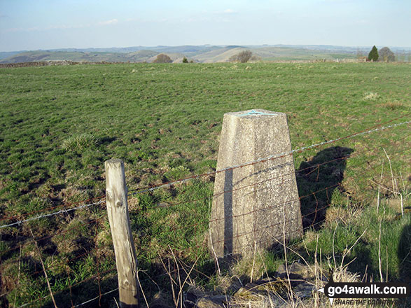
The summit of Grindon Moor (Grindon Moor) is marked by an Ordnance Survey Trig Point.
Not familiar with this top?
You can walk/hike to the top of Grindon Moor (Grindon Moor) by using any of these 4 easy‑to‑follow route maps:
Walk s108 Butterton and Upper Elkstone from Onecote
Wild(ish) Moorland walk
   |
|---|
Vital Statistics:
| Length: | 7.75ml (12.5km) |
|---|---|
| Ascent: | 1,139ft (347m) |
| Time: | 4 hrs |
| Grade: |  (Moderate) (Moderate) |
Route Summary:
Onecote - Hamps Way - Onecote Grange - The River Hamps - Mixon Mines - Black Brook Farm - Breech Farm - Under The Hill Farm - Upper Elkstone - Ryecroft Farm - Hole Farm - Hill Farm - Butterton - The Twist - Grindon Moor (Grindon Moor) - Home Farm - Onecote
Walk s201 Grindon Moor, Grindon and Weag's Bridge from Butterton
Easy dale walking & and interesting church
|
|---|
Vital Statistics:
| Length: | 8.75ml (14km) |
|---|---|
| Ascent: | 1,690ft (515m) |
| Time: | 5 hrs |
| Grade: | (Moderate) |
Route Summary:
Butterton - Grindon Moor (Grindon Moor) - Ford - Ryebrook Farm - Grindon - Weag's Bridge - The Manifold Way - The River Manifold - Thor's Cave - Ladyside Wood - Dafar Bridge - Wettonmill - Hoo Brook - Butterton
Walk s216 Onecote, Grindon and The Manifold Way from Waterhouses
A lovely long walk through hills and dales
|
|---|
Vital Statistics:
| Length: | 11.5ml (18km) |
|---|---|
| Ascent: | 1,267ft (386m) |
| Time: | 5½ hrs |
| Grade: | (Moderate) |

Route Summary:
Waterhouses - Waterfall Cross - Martins Low - River Hamps - Ford - Onecote - Grindonmoor Gate - Grindon Moor (Grindon Moor) - Grindon - Lee House - The Manifold Way - Waterhouses
Walk s166 Butterton, Onecote and Upper Elkstone from Warslow
A moorland walk with some climbing
|
|---|
Vital Statistics:
| Length: | 9.5ml (15km) |
|---|---|
| Ascent: | 1,483ft (452m) |
| Time: | 5 hrs |
| Grade: |  (Moderate) (Moderate) |

Route Summary:
Warslow - Villa Farm - Clayton House - Wallacre - Hoo Brook - Butterton - The Twist - Grindon Moor (Grindon Moor) - Onecote - Butterton Moor End Farm - Butterton Moor - Golden Hill - Black Brook Farm - Breech Farm - Underhill Farm - Upper Elkstone - Moorside - Cowhay Head - Warslow
See Grindon Moor (Grindon Moor) and the surrounding tops on our free-to-access 'Google Style' Peak Bagging Maps:
The White Peak Area of The Peak District National Park
Less data - quicker to download
See Grindon Moor (Grindon Moor) and the surrounding tops on our unique, downloadable, PDF Peak Bagging Map:

NB: Whether you print off a copy or download it to your phone, this PDF Peak Baggers' Map might prove incredibly useful when your are up there on the tops and you cannot get a phone signal.
You can find Grindon Moor (Grindon Moor) & all the walks that climb it on these unique free-to-access Interactive Walk Planning Maps:
1:25,000 scale OS Explorer Map (orange/yellow covers):
1:50,000 scale OS Landranger Map (pink/magenta covers):
 Fellow go4awalkers who have already walked, climbed, scaled, summited, hiked & bagged Grindon Moor (Grindon Moor)
Mark Davidson walked up Grindon Moor (Grindon Moor) on May 2nd, 2013 [from/via/route] Walk s135 Revidge & Upper Elkstone from Butterton [with] Theresa [weather] Lovely & sunny, fantastic day
hannah1507 climbed it on July 9th, 2023 [with] Dan
To add (or remove) your name and experiences on this page - Log On and edit your Personal Mountain Bagging Record
Send us your photographs and pictures on, of, or from Grindon Moor (Grindon Moor)
If you would like to add your walk photographs and pictures to this page, please send them as email attachments (configured for any computer) along with your name to:
and we shall do our best to publish them.
(Guide Resolution = 300dpi. At least = 660pixels (wide) x 440 pixels (high).)

You can also submit photos via our Facebook Page.
NB. Please indicate where each photo was taken and whether you wish us to credit your photos with a Username or your First Name/Last Name.


