
![]()
Bradwell Moor
471m (1545ft)
The White Peak Area, The Peak District, Derbyshire, England
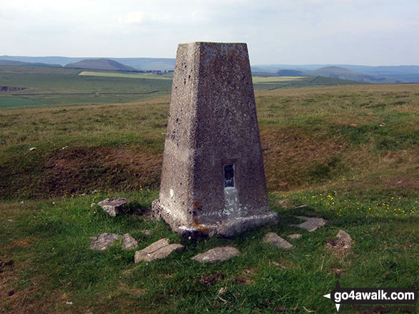
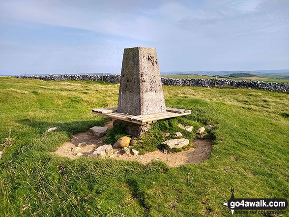
The summit of Bradwell Moor is marked by an Ordnance Survey Trig Point.
Not familiar with this top?
You can walk/hike to the top of Bradwell Moor by using either of these 2 easy‑to‑follow route maps:
Walk d119 Eldon Hill (Perryfoot) from Peak Forest
Superb views from a little climbed hill
   |
|---|
Vital Statistics:
| Length: | 5.75mls (9km) |
|---|---|
| Ascent: | 928ft (283m) |
| Time: | 3 hrs |
| Grade: |  (Moderate) (Moderate) |
Route Summary:
Peak Forest - Old Dam - Sweet Knoll Farm - Eldon Hole - Eldon Hill (Perryfoot) - Eldon Hill Quarries - The Limestone Way - Old Moor - Bradwell Moor - The Cop - West View - Old Dam - Peak Forest
Walk d155 Great Hucklow, Tideswell Moor and Bradwell Moor from Bradwell
Superb high level route with excellent views
|
|---|
Vital Statistics:
| Length: | 11.25ml (18km) |
|---|---|
| Ascent: | 1,759ft (536m) |
| Time: | 5.75hrs |
| Grade: |  (Moderate) (Moderate) |

Route Summary:
Bradwell - Bradwell Hills - Bradwell Edge - Robin Hood's Cross - Bleak Knoll (Abney Moor) - Durham Edge (Abney Moor) - Abney Moor - Abney Grange - Bretton Brook - Great Hucklow - Windmill - High Rake Mine - High Rake - Tideslow Rake - Tides Low - New Farm - Tideswell Moor - Bradwell Moor - Old Moor - Potter Barn - Smalldale Hall - Bradwell
See Bradwell Moor and the surrounding tops on our free-to-access 'Google Style' Peak Bagging Maps:
The White Peak Area of The Peak District National Park
Less data - quicker to download
See Bradwell Moor and the surrounding tops on our unique, downloadable, PDF Peak Bagging Map:

NB: Whether you print off a copy or download it to your phone, this PDF Peak Baggers' Map might prove incredibly useful when your are up there on the tops and you cannot get a phone signal.
You can find Bradwell Moor & all the walks that climb it on these unique free-to-access Interactive Walk Planning Maps:
1:25,000 scale OS Explorer Map (orange/yellow covers):
1:50,000 scale OS Landranger Map (pink/magenta covers):
 Fellow go4awalkers who have already walked, climbed, scaled, summited, hiked & bagged Bradwell Moor
Adrian Garside walked up Bradwell Moor on August 17th, 2019 [from/via/route] Peak Forest [with] on my own [weather] fine - Lovely circular walk from Peak Forest, up a lane & then old miners tracks forming part of the Limestone Way with a trigpoint then round to include Eldon Hill
Andrew Joss climbed it on May 11th, 2014 [from/via/route] Castleton [with] Barbara [weather] Sun, rain, wind & hail - Nice views
Mark Davidson has walked, climbed & bagged Bradwell Moor.
To add (or remove) your name and experiences on this page - Log On and edit your Personal Mountain Bagging Record
More Photographs & Pictures of views from, on, or of, Bradwell Moor
Send us your photographs and pictures on, of, or from Bradwell Moor
If you would like to add your walk photographs and pictures to this page, please send them as email attachments (configured for any computer) along with your name to:
and we shall do our best to publish them.
(Guide Resolution = 300dpi. At least = 660pixels (wide) x 440 pixels (high).)

You can also submit photos via our Facebook Page.
NB. Please indicate where each photo was taken and whether you wish us to credit your photos with a Username or your First Name/Last Name.


