Six easy to follow circular walk route maps from Upper Hulme in the The White Peak Area of The Peak District National Park, Staffordshire, England
   |
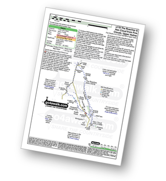
Vital Statistics:
| Length: | 3.75 miles (6 km) |
| Ascent: | 775 ft (236 m) |
| Time: | 2.25 hrs |
| Grade: |  |

Route Summary:
Five Clouds - Upper Hulme - Rockhall - Doxey Pool - The Roaches - Roach End - Spring Cottage - Five Clouds - Upper Hulme
|
Vital Statistics:
| Length: | 6 miles (9.5 km) |
| Ascent: | 1,234 ft (376 m) |
| Time: | 3½ hrs |
| Grade: |  |

Route Summary:
Five Clouds - Upper Hulme - Rockhall - The Roaches - Roach End - Back Forest - Lud's Church - Rock Chasm - Forest Wood - Roach End - Spring Cottage - Five Clouds - Upper Hulme
|
Vital Statistics:
| Length: | 4.75 miles (7.5 km) |
| Ascent: | 1,182 ft (360 m) |
| Time: | 3 hrs |
| Grade: | |
Route Summary:
Five Clouds - Pheasants Clough Farm - Roach Grange - Roach End - Bearstone Rock - The Roaches - Doxey Pool - Rockhall - Hen Cloud - Rockhall - Five Clouds
|
Vital Statistics:
| Length: | 8.25 miles (13 km) |
| Ascent: | 1,490 ft (454 m) |
| Time: | 4½ hrs |
| Grade: |  |
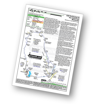
Route Summary:
Meerbrook - Lea End - Stockmeadows Farm - Meadows Farm - Buxton Brow Farm - Clough Head - Roach End - Bearstone Rock - The Roaches - Doxey Pool - Rockhall - Hen Cloud - Rockhall - Well Farm - Dains Mill - Upper Hulme - Butty Fold Farm - Tittesworth Reservoir - Meerbrook
|
Vital Statistics:
| Length: | 11.5 miles (18.5 km) |
| Ascent: | 2,274 ft (693 m) |
| Time: | 6½ hrs |
| Grade: |  |

Route Summary:
Gradbach - The Dane Valley Way - Gradbach Youth Hostel - Black Brook - Forest Wood - Roach End - The Roaches - Doxey Pool - Rockhall - Hen Cloud - Well Farm - Dains Mill - Upper Hulme - Butty Fold Farm - Staffordshire Moorlands Walk - Tittesworth Reservoir - Meerbrook - Stockmeadows Farm - Meadows Farm - Buxton Brow - Clough Head - Back Forest - Lud's Church - Rock Chasm - Black Brook - Gradbach Youth Hostel - The Dane Valley Way - Gradbach
|
Vital Statistics:
| Length: | 9 miles (14.5 km) |
| Ascent: | 1,795 ft (547 m) |
| Time: | 5 hrs |
| Grade: | |

Route Summary:
Upper Hulme - Dains Mill - Blue Hills - Black Brook Nature Reserve - Gib Torr Rocks - Moss Top - Moss End Farm - Black Brook - Roach End - The Roaches - Rockhall - Hen Cloud - Roaches Hall - Upper Hulme


