
![]()
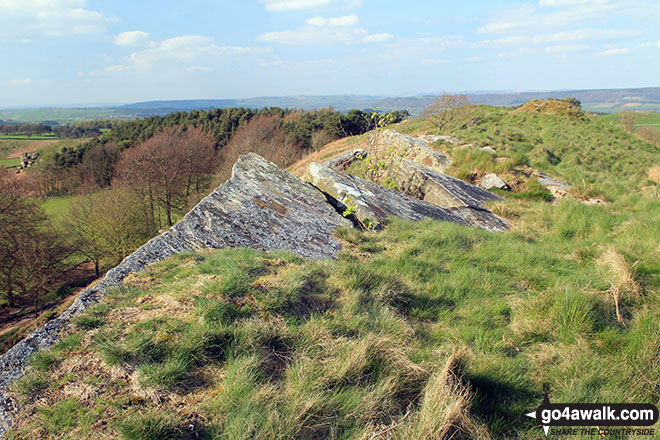
Anthony Hill
293m (961ft)
The White Peak Area, The Peak District, Derbyshire, England
Not familiar with this top?
   |
|---|
Vital Statistics:
| Length: | 4.5ml (7km) |
|---|---|
| Ascent: | 551ft (168m) |
| Time: | 2.25hrs |
| Grade: |  (Easy) (Easy) |
|
|---|
Vital Statistics:
| Length: | 3.75mls (6km) |
|---|---|
| Ascent: | 660ft (200m) |
| Time: | 3 hrs |
| Grade: |  (Easy) (Easy) |
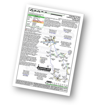
Route Summary:
Elton - The Limestone Way - Dudwood Lane - Robin Hood's Stride - Harthill Moor Wood - Cliffe Farm - Anthony Hill - Elton
|
|---|
Vital Statistics:
| Length: | 5.5ml (9km) |
|---|---|
| Ascent: | 984ft (300m) |
| Time: | 3 hrs |
| Grade: |  (Moderate) (Moderate) |
Route Summary:
Elton - The Limestone Way - Dudwood Lane - Birchover - The Mires - Robin Hood's Stride - Harthill Moor Wood - Cliffe Farm - Anthony Hill - Elton
|
|---|
Vital Statistics:
| Length: | 6.5ml (10.5km) |
|---|---|
| Ascent: | 1,145ft (349m) |
| Time: | 3½ hrs |
| Grade: | (Moderate) |
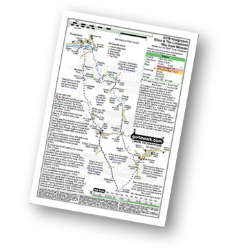
Route Summary:
Youlgreave - Bradford Dale - River Bradford - Mawstone Farm - Bleakley Plantation - Longshawe Wood - Anthony Hill - Elton - The Limestone Way - Robin Hood's Stride - Harthill Moor - Harthill Moor Wood - Bleakley Dike - River Bradford - Bradford Dale - Youlgreave
|
|---|
Vital Statistics:
| Length: | 8.5ml (13.5km) |
|---|---|
| Ascent: | 978ft (298m) |
| Time: | 4 hrs |
| Grade: | (Moderate) |
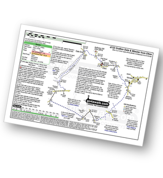
Route Summary:
Elton - Anthony Hill - Dale End (Elton) - Gratton Dale - Mouldridge Grange - Rockhurst Farm - Greenlow Farm - Winster - The Limestone Way - Elton
|
|---|
Vital Statistics:
| Length: | 8.75ml (14km) |
|---|---|
| Ascent: | 1,342ft (409m) |
| Time: | 4½ hrs |
| Grade: |  (Moderate) (Moderate) |
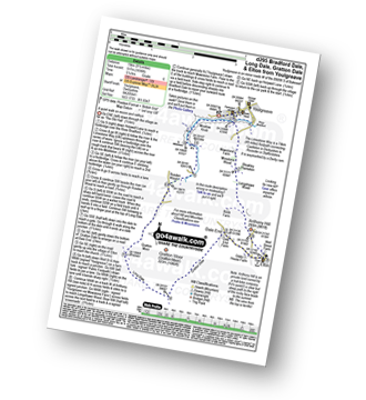
Route Summary:
Winster - The Limestone Way - Westhill Farm - Robin Hood's Stride - Harthill Moor - Harthill Moor Wood - Bleakley Dike - River Bradford - Bradford Dale - Youlgreave - Mawstone Farm - Bleakley Plantation - Longshawe Wood - Anthony Hill - Elton - Sacheveral Farm - Winster
|
|---|
Vital Statistics:
| Length: | 9.5ml (15km) |
|---|---|
| Ascent: | 1,696ft (517m) |
| Time: | 5.25hrs |
| Grade: |  (Moderate) (Moderate) |
Route Summary:
Youlgreave - The Limestone Way - Bradford Dale - Moatlow Knob - River Bradford - Rusden Wood - Gratton Moor - Long Dale - Gratton Dale - Dale End (Elton) - Elton - Anthony Hill - Longshawe Wood - Bleakley Plantation - Mawstone Farm - Bradford Dale - River Bradford - Youlgreave
See Anthony Hill and the surrounding tops on our free-to-access 'Google Style' Peak Bagging Maps:
The White Peak Area of The Peak District National Park
Less data - quicker to download
See Anthony Hill and the surrounding tops on our downloadable Peak Bagging Map in PDF format:

NB: Whether you print off a copy or download it to your phone, this PDF Peak Baggers' Map might prove incredibly useful when your are up there on the tops and you cannot get a phone signal.
You can find Anthony Hill & all the walks that climb it on these unique free-to-access Interactive Walk Planning Maps:
1:25,000 scale OS Explorer Map (orange/yellow covers):
1:50,000 scale OS Landranger Map (pink/magenta covers):
 Fellow go4awalkers who have already walked, climbed, summited & bagged Anthony Hill
Mark Davidson walked up Anthony Hill on April 15th, 2014 [from/via/route] Walk d295 Bradford Dale, Long Dale, Gratton Dale & Elton from Youlgreave [with] T [weather] Lovely sunshine & nice & warm. - Bradford Dale is absolutely stunning!
To add (or remove) your name and experiences on this page - Log On and edit your Personal Mountain Bagging Record
More Photographs & Pictures of views from, on or of Anthony Hill
Send us your photographs and pictures on, of, or from Anthony Hill
If you would like to add your walk photographs and pictures featuring views from, on or of Anthony Hill to this page, please send them as email attachments (configured for any computer) along with your name to:
and we shall do our best to publish them.
(Guide Resolution = 300dpi. At least = 660pixels (wide) x 440 pixels (high).)

You can also submit photos via our Facebook Page.
NB. Please indicate where each photo was taken and whether you wish us to credit your photos with a Username or your First Name/Last Name.
Not familiar with this top?


