Free Sample Walk Route Maps for UK walks from go4awalk.com
How to use this page:
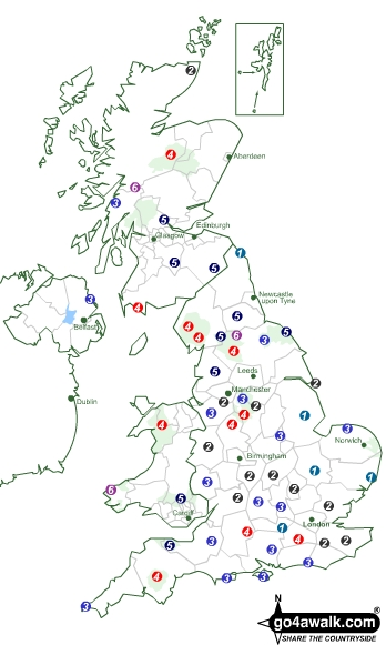
Click/Tap on a Coloured Circle to download a Walk as an Adobe Acrobat PDF File*
- Circles marked 1, 2 & 3 are
Easy to Moderate Walks; - Circles marked 4, 5 & 6 are
Moderate to Strenuous Walks and; - Circles marked 7, 8 & 9 are
Strenuous to Hard Walks.
See Help > Walk Grades for more information on our walk grading system.
GPX Waypoints:
To download and try some sample GPS Waypoints in GPX (.gpx) format see:
- bo124 Hownam Law from Morebattle, The Borders, Scotland
- sl106 Culter Fell from Culter Allers Farm, South Lanarkshire, Scotland
- c136 Mabbin Crag from Huck's Bridge, Cumbria, England
- c242 Latrigg from Keswick, The Lake District National Park, Cumbria, England
- de117 Steeperton Tor from Belstone, Dartmoor National Park, Devon, England
NB. To upload 'GPX format' GPS Waypoints to your GPS Device - connect your GPS to your computer via the USB cable and put the .gpx file into the GPS folder on your GPS Device. Alternatively, use 'EasyGPS' on a PC or 'MacGPSPro' on an Apple Macintosh or Garmin Basecamp which works on both.
GPS Waypoints:
To download and try some sample GPS Waypoints in text (.txt) format see:
- bo124 Hownam Law from Morebattle, The Borders, Scotland
- c136 Mabbin Crag from Huck's Bridge, Cumbria, England
- c242 Latrigg from Keswick, The Lake District National Park, Cumbria, England
- de117 Steeperton Tor from Belstone, Dartmoor National Park, Devon, England
NB. To upload 'Text format' GPS Waypoints to your GPS Device with 'GPS Utility' on a PC - see each link for full details.
If Peak Bagging is your thing then see Peak Bagging - How to get Started and then download our sample Peak Bagging Map - The Lake District Central Fells.
If you are looking to Walk all the Wainwrights in just 59 walks then download our sample Walk the Wainwrights Planning Map - The Central Fells.
If you prefer you can select your walk by: Ordnance Survey Explorer™ Maps (Orange Covers), Ordnance Survey Landranger® Maps (Pink Covers) or National Park/National Scenic Area
Alternatively, use our Walk Search which also includes lists of walks by area and information about climbing and bagging:-
- Wainwrights
- English and Welsh Mountains (Hewitts),
- English and Welsh Deweys,
- Scottish Munros,
- Scottish Corbetts,
- Scottish Grahams,
- Scottish Murdos and
- Marilyns and
- Bridgets,
If you are unfamiliar with the area you want to go walking - or just need some inspiration, look under Walk Ideas and Collections
If you want to go walking up a particular mountain or hill see The Mountains, Peaks, Tops & Hills of England, Scotland and Wales
So start walking better walks with go4awalk.com
To download our professionally researched and produced Walk Routes, our popular 'Best Walks in . . . lists', GPS Waypoint Data files, Peak Bagging Maps & Tick Lists and/or contact any of your fellow walkers on our Find-a-Friend Message Board you must have an active account and be logged on.
You'll get access to all the best walks in the UK for as long as you want - whether you walk twice a week or twice a year.
It's like buying a walking book - but with all your favourite walks, gps waypoints, new walking friends and peak bagging maps, fully up-to-date and easier to carry and simply fantastic value at less than 12.5p per walk/download/credit!
There is NO TIME LIMIT and NO ANNUAL CONTRACT so your account will last as long as you want it to or until you have used all your Credits*. This means you can enjoy all the benefits of being an Account holder when ever you want to for just one single easy payment.
So Log On and Start Walking Better Walks
*Requires Acrobat Reader, see Help > FAQs for details.

To contribute to go4awalk.com or to contact us about anything at all - see Talk To Us. For help see Help.
go4awalk.com and go4awalk.co.uk are registered trademarks of TMDH Limited.
Copyright © 2000-2025 TMDH Limited. All rights reserved.
Copyright Terms & Conditions Privacy Statement
A - Z Walks Home Log On/Accounts Photo Gallery Walk Ideas and Collections Fell Facts Hill Skills Walking Questions and Answers Your Stories News Competitions Product Reviews/Gear Tests Walking Gear Guides Peaks and Mountains Peak Bagging Find New Walking Friends Camping GPS Waypoints for Walking Contents Walk Search Talk To Us go4awalk.com Help Free Example Walks Newsletter


