UK Postcode CA11 - The 30 nearest easy-to-follow, circular walk route maps to you
The thirty nearest easy-to-follow, circular walk route maps to you in UK Postcode CA11 in Walk Grade Order
The UK cities, towns and villages in Cumbria, England that have CA11 in their UK Postcode include:
• Blencow • Bridgend • Calthwaite • Catterlen • Dacre • Dockray • Dowthwaitehead • Edenhall • Ellonby • Glenridding • Great Salkeld • Greystoke • Hutton • Hutton End • Hutton Roof • Johnby • Laithes • Lamonby • Matterdale End • Mosedale • Motherby • Mungrisdale • New Rent • Newbiggin • Newton Reigny • Patterdale • Penrith • Penruddock • Plumpton • Plumpton Head • Salkeld Dykes • Skelton • Stainton • Ulcat row • Unthank • Watermillock • Wreay •
Not familiar with the area around CA11?
See these 30 nearest walks to UK Postcode CA11 on a google map
   |
Vital Statistics:
| Length: | 1.5 miles (2.5 km) |
| Ascent: | 705ft (215m) |
| Time: | 1½ hrs |
| Grade: |  |
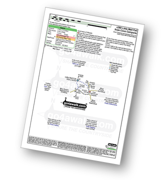
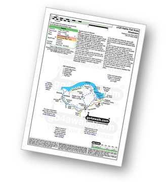
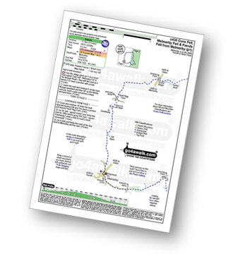
Route Summary:
Cove Park Campsite - Watermillock - Mellfell House - Little Mell Fell - The Hause - Cove Campsite - Watermillock.
|
Vital Statistics:
| Length: | 12.25 miles (19.5 km) |
| Ascent: | 3,254ft (992m) |
| Time: | 7½ hrs |
| Grade: |  |
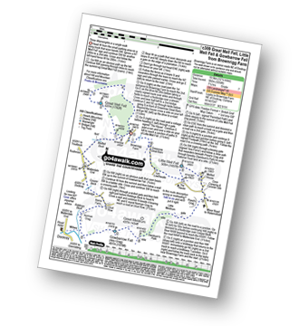
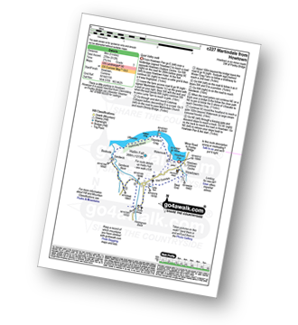
Route Summary:
Brownrigg Farm - Great Mell Fell - Greenrow Great Barn - Lowthwaite - Little Mell Fell - The Hause - Underwood - Cove Park Campsite - Watermillock - Priest's Crag - Great Meldrum - Gowbarrow Fell (Airy Crag) - Norman Crag - Ulcat Row - Matterdale End - Brownrigg Farm
|
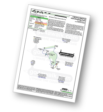
Vital Statistics:
| Length: | 3 miles (5 km) |
| Ascent: | 1,145ft (349m) |
| Time: | 2½ hrs |
| Grade: |  |
|
Vital Statistics:
| Length: | 8.5 miles (13.5 km) |
| Ascent: | 1,994ft (608m) |
| Time: | 5 hrs |
| Grade: |  |
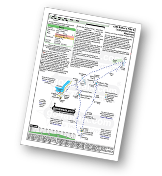
Route Summary:
Howtown - Lock Bank - White Knott - Barton Fell - Whinny Crag - Arthur's Pike - Loadpot Hill - Bonscale Pike - Swarthbeck Gill - Howtown
|
Vital Statistics:
| Length: | 4.75 miles (7.5 km) |
| Ascent: | 1,292ft (394m) |
| Time: | 3 hrs |
| Grade: |  |
Route Summary:
Howtown - St Peter's Church - Hallin Fell - Geordie's Crag - Hallinhag Wood - Sandwick - Sandwick Beck - Howtown
|
Vital Statistics:
| Length: | 5 miles (8 km) |
| Ascent: | 912ft (278m) |
| Time: | 2.75hrs |
| Grade: | |
Route Summary:
Howtown - The Coombs - St Peter's Church - Lanty Tarn - Martindale - Christy Bridge - Howegrain Beck - Sandwick Beck - Sandwick - Hallinhag Wood - Geordie's Crag - Waternook - Howtown
|
Vital Statistics:
| Length: | 7.5 miles (12 km) |
| Ascent: | 2,283ft (696m) |
| Time: | 5.25hrs |
| Grade: | |
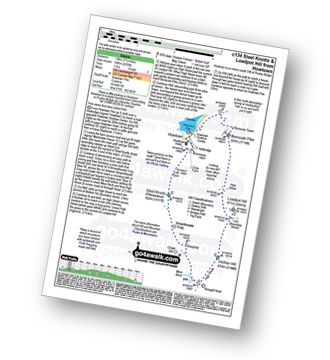
Route Summary:
Howtown - Steel Knotts (Pikeawassa) - Brownthwaite Crag - Keasgill Head - Wether Hill (South Top) - Wether Hill - Loadpot Hill - Bonscale Pike - Bonscale Tower - Swarthbeck Gill - Howtown
|
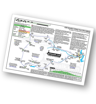
Vital Statistics:
| Length: | 11.25 miles (18 km) |
| Ascent: | 2,736ft (834m) |
| Time: | 6.75hrs |
| Grade: | |
Route Summary:
St Peter's Church (Martindale) - Howtown - Swarthbeck Gill - White Knott - Barton Fell - Whinny Crag - Arthur's Pike - Swarth Beck - Bonscale Tower - Bonscale Pike - Loadpot Hill - Wether Hill - Wether Hill (South Top) - Keasgill Head - Steel Knotts (Pikeawassa) - Steel End - St Peter's Church (Martindale) - Howtown
|
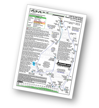
Vital Statistics:
| Length: | 14.5 miles (23 km) |
| Ascent: | 4,555ft (1,388m) |
| Time: | 9.75hrs |
| Grade: |  |
Route Summary:
St Peter's Church (Martindale) - Howtown - Steel Knotts (Pikeawassa) - Keasgill Head - High Raise (Mardale) - Kidsty Pike - Rampsgill Head - The Knott - Rest Dodd - The Nab - Satura Crag - Brock Crags - Angle Tarn (Martindale) - Angletarn Pikes - Bedafel Knott - Beda Head (Beda Fell) - Winter Crag - Christy Bridge - Howegrain Beck - Martindale - St Peter's Church (Martindale) - Howtown
|
Vital Statistics:
| Length: | 9.75 miles (15.5 km) |
| Ascent: | 3,470ft (1,058m) |
| Time: | 7 hrs |
| Grade: | |
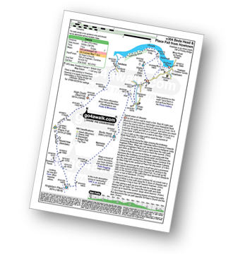
Route Summary:
St Peter's Church (Martindale) - Howtown - Howegrain Beck - Christy Bridge - Beda Head (Beda Fell) - Martindale Common - Angletarn Pikes - Angle Tarn (Martindale) - Boredale Hause - Steel Edge - Place Fell - High Dodd (Sleet Fell) - Sandwick - Hallinhag Wood - Geordies Crag - Hallin Fell (Martindale) - Howtown
|
Vital Statistics:
| Length: | 12.5 miles (20 km) |
| Ascent: | 3,769ft (1,149m) |
| Time: | 8½ hrs |
| Grade: |  |
Route Summary:
Christy Bridge - Martindale - Dale Head Farm - Heck Crag - Angle Tarn - Buck Crag - Brock Crags - Satura Crag - The Nab (Martindale) - Rest Dodd - The Knott - Rampsgill Head - Kidsty Pike - High Raise (Mardale) - Red Crag - Keasgill Head - Christy Bridge
|
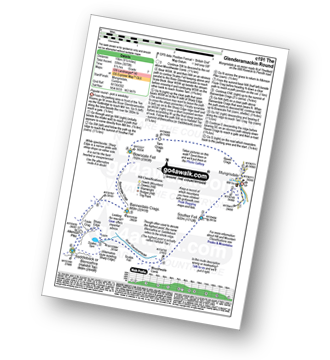
Vital Statistics:
| Length: | 11 miles (17.5 km) |
| Ascent: | 3,264ft (995m) |
| Time: | 7.25hrs |
| Grade: | |
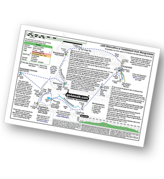
Route Summary:
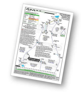
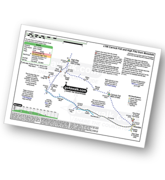
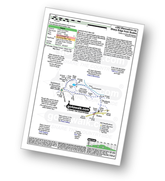
Mungrisdale - Souther Fell - River Glendermackin - Brunt Knott - Scales Beck - Scales Tarn - Sharp Edge - Atkinson Pike - Blencathra or Saddleback (Hallsfell Top) - Mungrisdale Common - Bannerdale Crags - Bowscale Fell - Tarn Crags Top - Raven Crags - Mungrisdale
|
Vital Statistics:
| Length: | 7.75 miles (12.5 km) |
| Ascent: | 2,453ft (748m) |
| Time: | 5.25hrs |
| Grade: | |
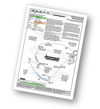
Route Summary:
Mungrisdale - Souther Fell - River Glendermackin - Bannerdale Crags - Bowscale Fell - Mungrisdale
|
Vital Statistics:
| Length: | 9.5 miles (15 km) |
| Ascent: | 3,070ft (936m) |
| Time: | 6½ hrs |
| Grade: | |
Route Summary:
Mungrisdale - Souther Fell - River Glendermackin - Brunt Knott - Scales Beck - Scales Tarn - Sharp Edge - Atkinson Pike - Blencathra or Saddleback (Hallsfell Top) - Foule Crag - Bannerdale Crags - Bowscale Fell - Tarn Crags Top - Raven Crags - Mungrisdale
|
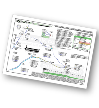
Vital Statistics:
| Length: | 4.5 miles (7 km) |
| Ascent: | 1,204ft (367m) |
| Time: | 3 hrs |
| Grade: | |
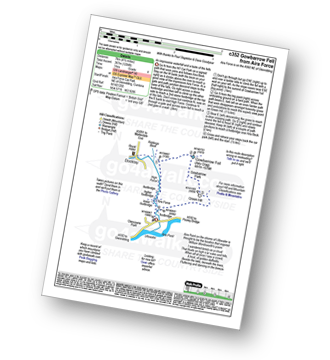
Route Summary:
Aira Force National Trust Car Park (nr Glenridding) - Aira Force - Riddings Beck - Waterfalls - High Force - Gowbarrow Fell (Airy Crag) - Gowbarrow Park - Green Hill (Gowbarrow Fell) - Aira Force Car Park.
Not familiar with the area around CA11?
See these 30 nearest walks to UK Postcode CA11 on a google map
|
Vital Statistics:
| Length: | 7.25 miles (11.5 km) |
| Ascent: | 1,752ft (534m) |
| Time: | 4½ hrs |
| Grade: |  |
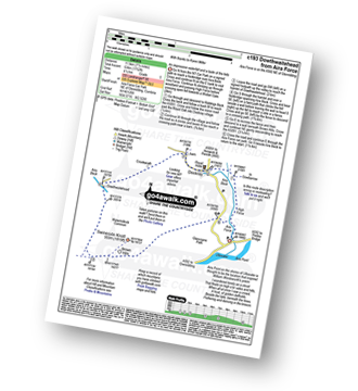
Route Summary:
Aira Force National Trust Car Park (nr Glenridding) - Aira Force - Riddings Beck - Waterfalls - High Force - Dockray - Aira Beck - Matterdale Common - Dowthwaitehead - Brown Hills - Swineside Knott - Glencoyne Park - Aira Force Car Park.
|
Vital Statistics:
| Length: | 11 miles (17.5 km) |
| Ascent: | 2,288ft (697m) |
| Time: | 6.25hrs |
| Grade: | |
Route Summary:
Melmerby - Meikle Awfell - Cuns Fell - Maiden Way (Roman Road) - Meg's Cairn - Melmerby Fell - Knapside Hill - Little Knapside Hill - Fiend's Fell - Twotop Bridge - Hazel Rigg Farm - Gamblesby - Gill Beck - Melmerby
|
Vital Statistics:
| Length: | 8.75 miles (14 km) |
| Ascent: | 2,129ft (649m) |
| Time: | 5½ hrs |
| Grade: | |
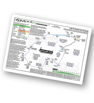
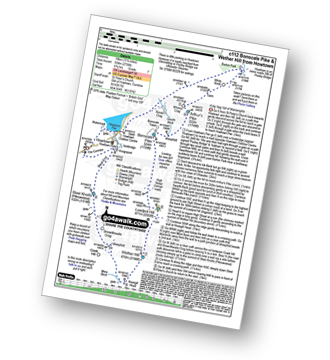
Route Summary:
Red Moss Nr Dockray - Matterdale Common - Wolf Crags - Bruts Moss - Randerside - Great Dodd - Watson's Dodd - Stybarrow Dodd - Green Side (White Stones) - Hart Side - Dowthwaitehead - Red Moss.
|
Vital Statistics:
| Length: | 11.25 miles (18 km) |
| Ascent: | 2,680ft (817m) |
| Time: | 6.75hrs |
| Grade: | |
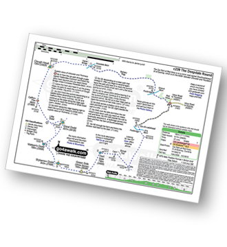
Route Summary:
Red Moss Nr Dockray - Barbary Rigg - Matterdale Common - Mariel Bridge - White Pike (Clough Head) - Clough Head - Calfhow Pike - Little Dodd (St John's Common) - Great Dodd - Watson's Dodd - Stybarrow Dodd - Green Side (White Stones) - Hart Side - Dowthwaitehead - Red Moss.
|
Vital Statistics:
| Length: | 8.25 miles (13 km) |
| Ascent: | 2,011ft (613m) |
| Time: | 5 hrs |
| Grade: | |
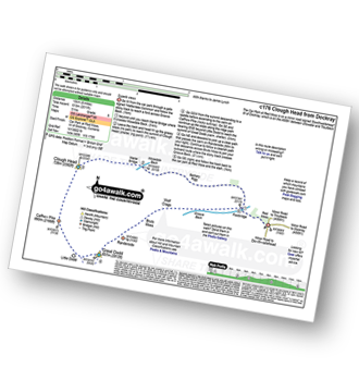
Route Summary:
Red Moss Nr Dockray - Barbary Rigg - Matterdale Common - Mariel Bridge - White Pike (Clough Head) - Clough Head - Calfhow Pike - Little Dodd (St John's Common) - Great Dodd - Randerside - Bruts Moss - Wolf Crags - Red Moss.
|
Vital Statistics:
| Length: | 9.5 miles (15 km) |
| Ascent: | 2,140ft (652m) |
| Time: | 5½ hrs |
| Grade: | |
Route Summary:
Stone Ends Farm - Apronful of Stones - Rake Trod - Further Gill Sike - Scurth - The Trough - Carrock Fell - Round Knott (Caldbeck) - Miton Hill (Caldbeck) - Red Gate (Track) - High Pike (Caldbeck) - Hare Stones - Great Lingy Hill - Miller Moss - Lingy Hut - Grainsgill Beck - The Cumbria Way - River Caldew - Swineside - Mosedale (Mungrisdale) - Stone Ends Farm
|
Vital Statistics:
| Length: | 14 miles (22.5 km) |
| Ascent: | 2,978ft (908m) |
| Time: | 8.25hrs |
| Grade: | |
Route Summary:
Stone Ends Farm - Apronful of Stones - Rake Trod - Further Gill Sike - Scurth - The Trough - Carrock Fell - Round Knott (Caldbeck) - Miton Hill (Caldbeck) - Red Gate (Track) - High Pike (Caldbeck) - Hare Stones - Great Lingy Hill - Miller Moss - Lingy Hut - Grainsgill Beck - Knott (Uldale Fells) - Litle Calva - Great Calva - The Cumbria Way - Wiley Beck - River Caldew - Burdell - Gill - Wet Swine Gill - Grainsgill Beck - Swineside - Mosedale (Mungrisdale) - Stone Ends Farm
|
Vital Statistics:
| Length: | 10.75 miles (17 km) |
| Ascent: | 2,437ft (743m) |
| Time: | 6 hrs |
| Grade: | |
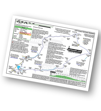
Route Summary:
Kirkland - Kirkland Beck - Cocklick Scar - Plylier's Gap - High Cap - Ironwell Band - The Pennine Way - Cross Fell - Crowdundle Head - Tees Head - Sturba Nook - Wildboar Scar - Grumply Hill - Littledale Beck - Cringle Moor - Blencarn - Blencarn Lake - Blencarn Beck - Kirk Hill - Kirkland
|
Vital Statistics:
| Length: | 6.25 miles (10 km) |
| Ascent: | 2,565ft (782m) |
| Time: | 4.75hrs |
| Grade: | |
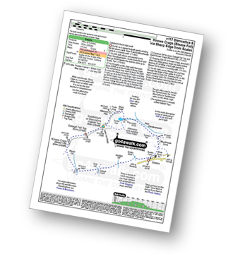
Route Summary:
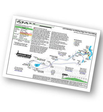
Scales - Mousthwaite Comb - Scales Fell - Brunt Knott - Scales Beck - Scales Tarn - Sharp Edge - Atkinson Pike - Blencathra or Saddleback (Hallsfell Top) - Gategill Fell Top - Knowe Crag (Blease Fell) - Scales
|
Vital Statistics:
| Length: | 5.25 miles (8.5 km) |
| Ascent: | 2,255ft (687m) |
| Time: | 4½ hrs |
| Grade: | |
Route Summary:
Scales - Mousthwaite Comb - Scales Fell - Brunt Knott - Scales Beck - Scales Tarn - Sharp Edge - Atkinson Pike - Blencathra or Saddleback (Hallsfell Top) - Scales Fell - Mousthwaite Comb - Scales
|
Vital Statistics:
| Length: | 7 miles (11 km) |
| Ascent: | 1,299ft (396m) |
| Time: | 3.75hrs |
| Grade: | |
Route Summary:
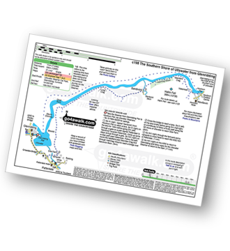
Glenridding - Glenridding Pier - Ullswater Steamer - Howtown Pier - Geordie's Crag - Halinhag Wood - Sandwick - Long Crag (Ullswater) - Silver Point - Ullswater - Blowick - Rooking - Side Farm - Patterdale
|
Vital Statistics:
| Length: | 10.75 miles (17 km) |
| Ascent: | 3,449ft (1,051m) |
| Time: | 7.25hrs |
| Grade: | |
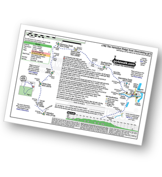
Route Summary:
Glenridding - Birkhouse Moor - Hole-in-the-Wall - Red Tarn (Helvellyn) - Catstye Cam - Swirral Edge - Helvellyn - Lower Man (Helvellyn) - White Side - Raise (Helvellyn) - Sticks Pass - Lucy's Tongue - Glenridding Beck - Glenridding
|
Vital Statistics:
| Length: | 8.5 miles (13.5 km) |
| Ascent: | 3,278ft (999m) |
| Time: | 6½ hrs |
| Grade: | |
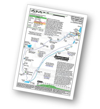
Route Summary:
Glenridding - Birkhouse Moor - Hole-in-the-Wall - Red Tarn (Helvellyn) - Bleaberry Crag - Low Spying How - High Spying How - Striding Edge (High Spying How) - Helvellyn - Swirral Edge - Catstye Cam - Hole-in-the-Wall - Brownend Plantation - Grisedale Beck - Lanty's Tarn - Keldas - Glenridding
|
Vital Statistics:
| Length: | 10 miles (16 km) |
| Ascent: | 3,382ft (1,031m) |
| Time: | 7 hrs |
| Grade: | |
Route Summary:
Glenridding - Birkhouse Moor - Hole-in-the-Wall - Red Tarn (Helvellyn) - Bleaberry Crag - Low Spying How - High Spying How - Striding Edge (High Spying How) - Helvellyn - Nethermost Pike - High Crag (Helvellyn) - Dollywaggon Pike - Grisdale Tarn - Ruthwaite Lodge - Grisedale Beck - Brownend Plantation - Lanty's Tarn - Keldas - Glenridding
|
Vital Statistics:
| Length: | 13 miles (21 km) |
| Ascent: | 4,359ft (1,329m) |
| Time: | 9.25hrs |
| Grade: | |
Route Summary:
Glenridding - Glenridding Dodd - Sheffield Pike - Green Side - Stybarrow Dodd - Sticks Pass - Raise (Helvellyn) - White Side - Lower Man (Helvellyn) - Helvellyn - Nethermost Pike - High Crag (Helvellyn) - Dollywaggon Pike - Grisdale Tarn - Grisedale Beck - Brownend Plantation - Lanty's Tarn - Keldas - Glenridding
Not familiar with the area around CA11?
See these 30 nearest walks to UK Postcode CA11 on a google map


