
![]()
Bonscale Pike
524m (1720ft)
The Far Eastern Fells, The Lake District, Cumbria, England

Not familiar with this top?
You can walk/hike to the top of Bonscale Pike by using any of these 3 easy‑to‑follow route maps:
Walk c134 Wether Hill and Loadpot Hill from Howtown
Fine views from less visited fells
   |
|---|
Vital Statistics:
| Length: | 7.5ml (12km) |
|---|---|
| Ascent: | 2,283ft (696m) |
| Time: | 5.25hrs |
| Grade: |  (Moderate) (Moderate) |

Route Summary:
Howtown - Steel Knotts (Pikeawassa) - Brownthwaite Crag - Keasgill Head - Wether Hill (South Top) - Wether Hill - Loadpot Hill - Bonscale Pike - Bonscale Tower - Swarthbeck Gill - Howtown
Walk c283 Arthur's Pike and Loadpot Hill from Howtown
One of the best views in the Lake District
|
|---|
Vital Statistics:
| Length: | 8.5ml (13.5km) |
|---|---|
| Ascent: | 1,994ft (608m) |
| Time: | 5 hrs |
| Grade: | (Moderate) |

Route Summary:
Howtown - Lock Bank - White Knott - Barton Fell - Whinny Crag - Arthur's Pike - Loadpot Hill - Bonscale Pike - Swarthbeck Gill - Howtown
Walk c112 Bonscale Pike and Wether Hill from Howtown
A big 'bag' full of Wainwrights
|
|---|
Vital Statistics:
| Length: | 11.25ml (18km) |
|---|---|
| Ascent: | 2,736ft (834m) |
| Time: | 6.75hrs |
| Grade: |  (Hard) (Hard) |

Route Summary:
St Peter's Church (Martindale) - Howtown - Swarthbeck Gill - White Knott - Barton Fell - Whinny Crag - Arthur's Pike - Swarth Beck - Bonscale Tower - Bonscale Pike - Loadpot Hill - Wether Hill - Wether Hill (South Top) - Keasgill Head - Steel Knotts (Pikeawassa) - Steel End - St Peter's Church (Martindale) - Howtown
See Bonscale Pike and the surrounding tops on our free-to-access 'Google Style' Peak Bagging Maps:
The Far Eastern Fells of The Lake District National Park
Less data - quicker to download
The Whole of The Lake District National Park
More data - might take a little longer to download
See Bonscale Pike and the surrounding tops on our unique, downloadable, PDF Peak Bagging Maps:

NB: Whether you print off a copy or download it to your phone, these PDF Peak Baggers' Maps might prove incredibly useful when your are up there on the tops and you cannot get a phone signal.
*This version is marked with the walk routes you need to follow to Walk all 214 Wainwrights in just 59 walks.
You can find Bonscale Pike & all the walks that climb it on these unique free-to-access Interactive Walk Planning Maps:
1:25,000 scale OS Explorer Map (orange/yellow covers):
1:50,000 scale OS Landranger Map (pink/magenta covers):
 Fellow go4awalkers who have already walked, climbed, scaled, summited, hiked & bagged Bonscale Pike
James Hughes walked up Bonscale Pike on September 17th, 2024 [from/via/route] c112 Bonscale Pike & Wether Hill from Howtown [weather] Overcast with sunny spells. Blustery on tops at times. Cool on tops, but good walking temperature. - Road closed to Howtown so started walk other side of Barton Fell lengthening walk. Gentle climbs with bleak landscape over High Street Range. Good views of Ullswater. Long walk back from Steel End descent. Wainwright sitting stone overlooking Ullswater.
Geoff Hand climbed it on June 25th, 2024 [from/via/route] Walk C112 From Howtown, Arthur's Pike, Bonscale Pike, Loadpot Hill, Wether Hill & Steel Knotts [with] Anthony Atkinson, running friend. [weather] A bit Misty, Warm & humid. - Nice drive through Pooley Bridge where I haven't been for a long time (actually built a new bridge!). Had a pint outside the Sun Inn on the way home.
Mr M A Blanchard bagged it on April 19th, 2024 [from/via/route] With all the mutts apart from Ted [with] Florence, Millie and Woodie [weather] Cold, bright
John Ramsbottom hiked Bonscale Pike on January 28th, 2024 [from/via/route] St Peters Church Howton [with] Lola [weather] Windy, but mild for time of year - No pub this time . Being good. Over night camp on Barton fell
Andrew Thornton summited on August 8th, 2023 [from/via/route] Troutbeck [with] Jenny [weather] Overcast - Very steep at first. Long finish. Drink at the Howtown pub.
To add (or remove) your name and experiences on this page - Log On and edit your Personal Mountain Bagging Record
. . . [see more walk reports]
More Photographs & Pictures of views from, on, or of, Bonscale Pike
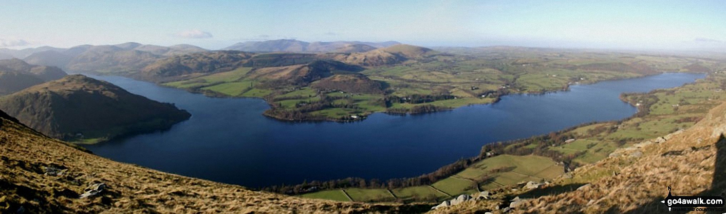

Ullswater from Yew Crag (Gowbarrow Fell) with Arthur's Pike and Bonscale Pike beyond
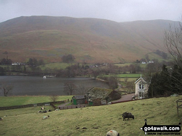
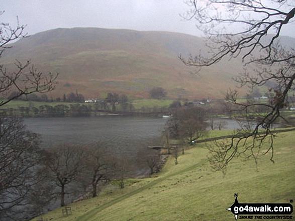
Waternook, Howtown and Ullswater with Bonscale Pike beyond from near Geordie's Crag
Send us your photographs and pictures on, of, or from Bonscale Pike
If you would like to add your walk photographs and pictures to this page, please send them as email attachments (configured for any computer) along with your name to:
and we shall do our best to publish them.
(Guide Resolution = 300dpi. At least = 660pixels (wide) x 440 pixels (high).)

You can also submit photos via our Facebook Page.
NB. Please indicate where each photo was taken and whether you wish us to credit your photos with a Username or your First Name/Last Name.


