
![]()
Wether Hill (South Top)
674m (2212ft)
The Far Eastern Fells, The Lake District, Cumbria, England
Wether Hill (South Top) was found to be slightly higher than Wether Hill in March 2012 so becomes the local 'Nuttall'. However Wether Hill remains the local 'Wainwright'.
Not familiar with this top?
   |
|---|
Vital Statistics:
| Length: | 7.5ml (12km) |
|---|---|
| Ascent: | 2,283ft (696m) |
| Time: | 5.25hrs |
| Grade: |  (Moderate) (Moderate) |
Route Summary:
Howtown - Steel Knotts (Pikeawassa) - Brownthwaite Crag - Keasgill Head - Wether Hill (South Top) - Wether Hill - Loadpot Hill - Bonscale Pike - Bonscale Tower - Swarthbeck Gill - Howtown
|
|---|
Vital Statistics:
| Length: | 11.25ml (18km) |
|---|---|
| Ascent: | 2,736ft (834m) |
| Time: | 6.75hrs |
| Grade: |  (Hard) (Hard) |
Route Summary:
St Peter's Church (Martindale) - Howtown - Swarthbeck Gill - White Knott - Barton Fell - Whinny Crag - Arthur's Pike - Swarth Beck - Bonscale Tower - Bonscale Pike - Loadpot Hill - Wether Hill - Wether Hill (South Top) - Keasgill Head - Steel Knotts (Pikeawassa) - Steel End - St Peter's Church (Martindale) - Howtown
|
|---|
Vital Statistics:
| Length: | 14.5ml (23km) |
|---|---|
| Ascent: | 3,364ft (1,025m) |
| Time: | 8½ hrs |
| Grade: |  (Hard) (Hard) |
Route Summary:
Mardale Head (Haweswater Reservoir) - Small Water - Nan Bield Pass - Mardale Ill Bell - High Street - Straits of Riggindale - The Knott - Rampsgill Head - Kidsty Pike - High Raise (Mardale) - Raven Howe - Red Crag - Keasgill Head - Wether Hill (South Top) - Wether Hill - Bampton Common - Low Kop - Measand Beck - Haweswater Reservoir - Wainwright's Coast to Coast Walk - Bowderthwaite Bridge - The Rigg - Mardale Head
See Wether Hill (South Top) and the surrounding tops on our free-to-access 'Google Style' Peak Bagging Maps:
The Far Eastern Fells of The Lake District National Park
Less data - quicker to download
The Whole of The Lake District National Park
More data - might take a little longer to download
See Wether Hill (South Top) and the surrounding tops on our downloadable Peak Bagging Maps in PDF format:

NB: Whether you print off a copy or download it to your phone, these PDF Peak Baggers' Maps might prove incredibly useful when your are up there on the tops and you cannot get a phone signal.
*This version is marked with the walk routes you need to follow to Walk all 214 Wainwrights in just 59 walks.
You can find Wether Hill (South Top) & all the walks that climb it on these unique free-to-access Interactive Walk Planning Maps:
1:25,000 scale OS Explorer Map (orange/yellow covers):
1:50,000 scale OS Landranger Map (pink/magenta covers):
 Fellow go4awalkers who have already walked, climbed, summited & bagged Wether Hill (South Top)
Jon Floyd walked up Wether Hill (South Top) on July 26th, 2023 [weather] Clear day
Simon Boddy climbed Wether Hill (South Top) on July 11th, 2022 [from/via/route] Fusedale [with] My girlfriend [weather] Sunny & clear
Michael Austin bagged Wether Hill (South Top) on July 9th, 2020 [from/via/route] C112
Paul Ward hiked Wether Hill (South Top) on August 13th, 2021 [from/via/route] Started from Howtown Hotel Bonscale Pike, [with] Jamie [weather] Dry, overcast with strong winds on tops.
John Bryers summited Wether Hill (South Top) on May 11th, 2018 [from/via/route] Walked from St. Peter's church up front of Bonscale Pike, Arthur's Pike, Loadpot Hill, Wether Hill, High Raise, Kidsty Pike, Rampsgill Head, Rest Dodd & The Nab dropping back into Bannerdale & road back to church. [with] With Mya my faithful 12 year old Patterdale Terrier. [weather] Weather sunny to start, slight wind on ridges with light rain at times ending with some warm sunshine.
Simon Burgess conquered Wether Hill (South Top) on June 27th, 2021 [from/via/route] From Martindale. Wether Hill, Loadpot Hill, Swarf Fell [with] Solo
Christina Lander scaled Wether Hill (South Top) on October 15th, 2020 [from/via/route] St Peter's Church, Martindale - Hallin Fell - Bonscale Pike - Arthur's Pike - Loadpot Hill - Wether Hill - St Martin's Church - St Peter's Church [with] Dick [weather] Mostly bright & sunny, clouded over at times - A bit of a drive from our cottage at High Ireby, & the journey was made longer by Pooley Bridge being closed
Christine Shepherd walked up Wether Hill (South Top) on March 18th, 2010 [from/via/route] Howtown using walk c112 [with] Jenny [weather] Bright & cold getting cloudier throughout the day. - Climbed again on a lovely day, 24.7.20 using the same route.
Richard Marshall climbed Wether Hill (South Top) on July 18th, 2020 [from/via/route] C112 [with] Bo and Steve Simcock [weather] Wet & misty at first. Sunny & bright later
Claire Kirk bagged Wether Hill (South Top) on July 16th, 2020 [from/via/route] Howtown [with] Alone [weather] Very fine day
To add (or remove) your name and experiences on this page - Log On and edit your Personal Mountain Bagging Record
. . . [see more walk reports]
More Photographs & Pictures of views from, on or of Wether Hill (South Top)
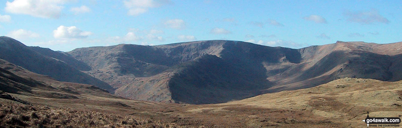
Harter Fell (Mardale) (far left), Nan Bield Pass, Rough Crag, Riggindale Crag, High Street, Kidsty Pike, High Raise (Mardale) Wether Hill and Wether Hill (South Top) from the cairn marking the high point on the Old Corpse Road (Haweswater)
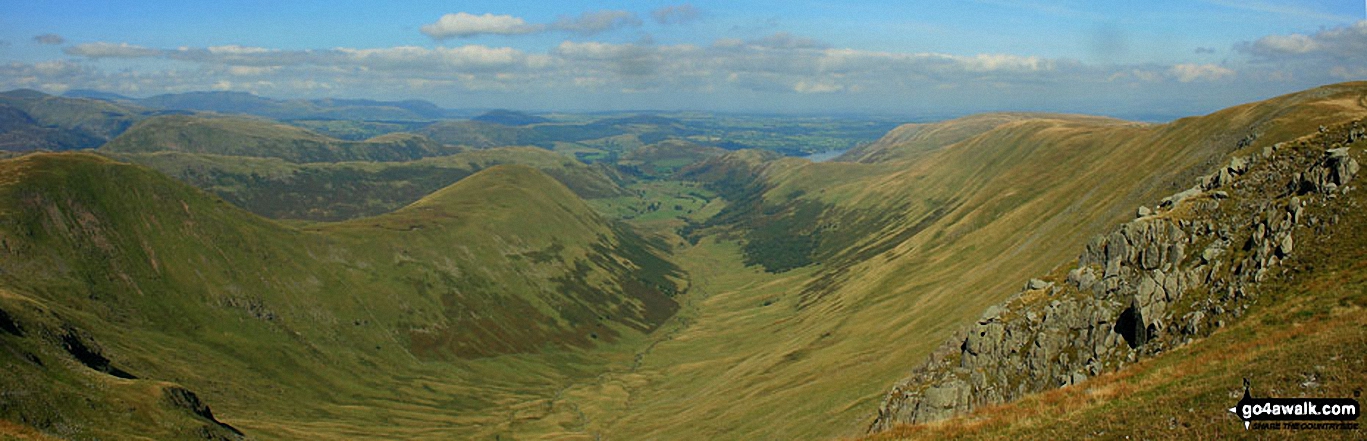
Rest Dodd (far left), The Nab (left), The Ramps Gill Valley, Wether Hill, Wether Hill (South Top) Keasgill Head, Red Crag, Raven Howe and High Raise (Mardale) (right) from Rampsgill Head
Send us your photographs and pictures on, of, or from Wether Hill (South Top)
If you would like to add your walk photographs and pictures featuring views from, on or of Wether Hill (South Top) to this page, please send them as email attachments (configured for any computer) along with your name to:
and we shall do our best to publish them.
(Guide Resolution = 300dpi. At least = 660pixels (wide) x 440 pixels (high).)

You can also submit photos via our Facebook Page.
NB. Please indicate where each photo was taken and whether you wish us to credit your photos with a Username or your First Name/Last Name.
Not familiar with this top?


