The Mountains, Peaks, Tops and Hills in The Dark Peak Area of The Peak District, Derbyshire, Greater Manchester, West Yorkshire and South Yorkshire with all the tops you have already bagged in first & then the ones you are yet to climb second.
The Dark Peak Area of The Peak District National Park, Derbyshire, Greater Manchester, West Yorkshire and South Yorkshire is area within the National Park boundary north of the A6 from Hazel Grove to Chapel-en-le-Frith, the A623 to Sparrowpit, the minor road from Sparrowpit along Rushup Edge to Castleton and the A6187 from Castleton to Sheffield.
If you include the Marilyns, the Bridgets (Hills) and all the Mountains, Tops, Peaks and Hills with a Trig Point on them there are 51 tops to climb, bag & conquer and the highest point is Kinder Scout at 636m (2,087ft).
To see these Mountains, Peaks, Tops and Hills displayed in different ways - see the options in the left-hand column and towards the bottom of this page.
![]() Your Personal Bagging Record for The Dark Peak Area of The Peak District
Your Personal Bagging Record for The Dark Peak Area of The Peak District
When logged on, you can mark each Mountain, Peak, Top or Hill as 'bagged' by either:
- if you opt to display the tops in this area using a google map, click or tap on its symbol on the map below. This will open a text window. Click or tap on the 'Record [mountain name] as Bagged, Climbed & Conquered' link towards the bottom of the text window, or
- if you opt to display the tops in this area as a list, click or tap on the red 'not yet' symbol to the right of the name of each 'top'
Either method will open a new page where you can complete all your details such as:
- when you bagged the Mountain, Peak, Top or Hill;
- which route you took
- who you went with
- what the weather was like
- any other comment that will remind you of the day
Once you have completed your details and click or tap the submit button, you will automatically return to this page and the top you bagged will show with a green tick.
NB. None of the above fields are 'mandatory' - you can leave them blank if you wish.
NNB. You also have the option whether to display your peak bagging exploits to other users of this site or keep them private so only you can see them when you are logged on.
Furthermore, since you can also access your Personal Mountain & Hill Bagging Record via go4awalk Mobile you can quickly & easily record, edit and view your achievements - whether you are at home/work on your desktop computer or in the pub/at the top of a mountain with your Mobile Phone. (You can even download your Personal Mountain & Hill Bagging Record as a .csv file for importing into and saving with spreadsheet software like Excel or NeoOffice!)
This facility costs one credit to initially access your personal bagging record. Once accessed, all other interactions, such as recording other Mountains, Peaks, Tops and Hills as 'bagged' or altering an existing bagging record, are free.
Click REGISTER to register and purchase credits.
LOG ON and RELOAD this page to show which Mountains, Peaks, Tops and Hills you have already climbed, bagged & conquered. [ . . . remove this text]
Scroll down this list of mountains, peaks, tops & hills below and tap/click on each name (in blue) to locate it on the map above.
See this list in: Alphabetical Order | Height Order‡
To reverse the order select the link again.
Mountain, Peak, Top or Hill already bagged:
Bagged
Top yet to be climbed, bagged & conquered:
Bagged

![]()
1. Kinder Scout
636m (2087ft)
Marilyn
See more details, photos, trip reports and easy-to-follow walks up Kinder Scout

![]()
2. Kinder Low (Kinder Scout)
633m (2078ft)
Bridget and Trig Point
See more details, photos, trip reports and easy-to-follow walks up Kinder Low (Kinder Scout)

![]()
3. Crowden Head (Kinder Scout)
631m (2071ft)
Bridget
See more details, photos, trip reports and easy-to-follow walks up Crowden Head (Kinder Scout)
![]()
4. Bleaklow Stones (Bleaklow Hill)
628m (2061ft)
Bridget
See more details, photos, trip reports and easy-to-follow walks up Bleaklow Stones (Bleaklow Hill)
![]()
5. Fairbrook Naze (Kinder Scout)
625m (2051ft)
Bridget
See more details, photos, trip reports and easy-to-follow walks up Fairbrook Naze (Kinder Scout)
![]()
6. The Edge (Kinder Scout)
624m (2048ft)
Bridget and Trig Point
See more details, photos, trip reports and easy-to-follow walks up The Edge (Kinder Scout)

![]()
7. Higher Shelf Stones
622m (2041ft)
Trig Point
See more details, photos, trip reports and easy-to-follow walks up Higher Shelf Stones
![]()
8. Crowden Tower (Kinder Scout)
619m (2032ft)
Bridget
See more details, photos, trip reports and easy-to-follow walks up Crowden Tower (Kinder Scout)
![]()
9. Seal Stones (Kinder Scout)
603m (1979ft)
Bridget
See more details, photos, trip reports and easy-to-follow walks up Seal Stones (Kinder Scout)
![]()
10. Grindslow Knoll (Kinder Scout)
601m (1972ft)
Bridget
See more details, photos, trip reports and easy-to-follow walks up Grindslow Knoll (Kinder Scout)
![]()
11. Barrow Stones
591m (1940ft)
Bridget
See more details, photos, trip reports and easy-to-follow walks up Barrow Stones
![]()
12. Edale Moor (Kinder Scout)
590m (1936ft)
Bridget and Trig Point
See more details, photos, trip reports and easy-to-follow walks up Edale Moor (Kinder Scout)

![]()
13. Black Hill (Soldier's Lump)
582m (1910ft)
Marilyn and Trig Point
See more details, photos, trip reports and easy-to-follow walks up Black Hill (Soldier's Lump)
![]()
14. Brown Knoll (Edale)
569m (1867ft)
Trig Point
See more details, photos, trip reports and easy-to-follow walks up Brown Knoll (Edale)
![]()
15. Margery Hill
546m (1791ft)
Bridget and Trig Point
See more details, photos, trip reports and easy-to-follow walks up Margery Hill
![]()
16. Featherbed Moss (Howden Edge)
545m (1788ft)
Bridget
See more details, photos, trip reports and easy-to-follow walks up Featherbed Moss (Howden Edge)
![]()
17. Featherbed Moss (Chew Reservoir)
541m (1775ft)
Bridget and Trig Point
See more details, photos, trip reports and easy-to-follow walks up Featherbed Moss (Chew Reservoir)
![]()
18. Outer Edge
541m (1775ft)
Bridget and Trig Point
See more details, photos, trip reports and easy-to-follow walks up Outer Edge
![]()
19. Back Tor (Derwent Edge)
538m (1766ft)
Trig Point
See more details, photos, trip reports and easy-to-follow walks up Back Tor (Derwent Edge)
![]()
20. Britland Edge Hill
524m (1720ft)
Bridget
See more details, photos, trip reports and easy-to-follow walks up Britland Edge Hill
![]()
21. Windgate Edge
523m (1716ft)
Bridget
See more details, photos, trip reports and easy-to-follow walks up Windgate Edge
![]()
22. Crookstone Knoll (Kinder Scout)
521m (1710ft)
Bridget
See more details, photos, trip reports and easy-to-follow walks up Crookstone Knoll (Kinder Scout)
![]()
23. Mam Tor
517m (1696ft)
Trig Point
See more details, photos, trip reports and easy-to-follow walks up Mam Tor
![]()
24. Westend Moor (Alport Moor)
503m (1650ft)
Bridget and Trig Point
See more details, photos, trip reports and easy-to-follow walks up Westend Moor (Alport Moor)
![]()
25. West Nab
500m (1641ft)
Trig Point
See more details, photos, trip reports and easy-to-follow walks up West Nab
![]()
26. Dead Edge End
499m (1637ft)
Bridget and Trig Point
See more details, photos, trip reports and easy-to-follow walks up Dead Edge End
![]()
27. Stable Stones Brow (Hoarstone Edge)
495m (1625ft)
Bridget
![]()
28. South Head (Hayfield)
494m (1621ft)
Bridget
See more details, photos, trip reports and easy-to-follow walks up South Head (Hayfield)
![]()
29. Millstone Rocks (Lad's Leap)
493m (1618ft)
Bridget
See more details, photos, trip reports and easy-to-follow walks up Millstone Rocks (Lad's Leap)
![]()
30. Pike Lowe
478m (1569ft)
Bridget
See more details, photos, trip reports and easy-to-follow walks up Pike Lowe
![]()
31. Lose Hill (Ward's Piece)
476m (1562ft)
Bridget
See more details, photos, trip reports and easy-to-follow walks up Lose Hill (Ward's Piece)
![]()
32. Snailsden
475m (1559ft)
Bridget and Trig Point
See more details, photos, trip reports and easy-to-follow walks up Snailsden
![]()
33. Mount Famine
473m (1552ft)
Bridget
See more details, photos, trip reports and easy-to-follow walks up Mount Famine
![]()
34. Alphin Pike
469m (1539ft)
Bridget and Trig Point
See more details, photos, trip reports and easy-to-follow walks up Alphin Pike
![]()
35. Winhill Pike (Win Hill)
462m (1516ft)
Bridget and Trig Point
See more details, photos, trip reports and easy-to-follow walks up Winhill Pike (Win Hill)
![]()
36. High Neb (Stanage Edge)
458m (1503ft)
Bridget and Trig Point
See more details, photos, trip reports and easy-to-follow walks up High Neb (Stanage Edge)
![]()
37. Stanage Edge (Stanage Edge)
457m (1500ft)
Bridget and Trig Point
See more details, photos, trip reports and easy-to-follow walks up Stanage Edge (Stanage Edge)
![]()
38. Dick Hill
453m (1487ft)
Bridget
See more details, photos, trip reports and easy-to-follow walks up Dick Hill
![]()
39. Ashway Rocks
452m (1483ft)
Bridget
See more details, photos, trip reports and easy-to-follow walks up Ashway Rocks
![]()
40. Chinley Churn
451m (1480ft)
Bridget and Trig Point
See more details, photos, trip reports and easy-to-follow walks up Chinley Churn
![]()
41. Great Dove Stone Rocks
450m (1477ft)
Bridget
See more details, photos, trip reports and easy-to-follow walks up Great Dove Stone Rocks
![]()
42. Back Tor (Hollins Cross)
438m (1438ft)
Bridget
See more details, photos, trip reports and easy-to-follow walks up Back Tor (Hollins Cross)
![]()
43. Higger Tor
434m (1424ft)
Bridget
See more details, photos, trip reports and easy-to-follow walks up Higger Tor
![]()
44. Burbage Rocks
429m (1408ft)
Bridget
See more details, photos, trip reports and easy-to-follow walks up Burbage Rocks
![]()
45. Bamford Moor
426m (1398ft)
Bridget
See more details, photos, trip reports and easy-to-follow walks up Bamford Moor
![]()
46. Cown Edge Rocks
410m (1345ft)
Bridget and Trig Point
See more details, photos, trip reports and easy-to-follow walks up Cown Edge Rocks
![]()
47. Lodge Moor (Ughill Moors)
409m (1342ft)
Bridget
See more details, photos, trip reports and easy-to-follow walks up Lodge Moor (Ughill Moors)
![]()
48. Onesmoor (Kirk Edge)
395m (1296ft)
Bridget and Trig Point
See more details, photos, trip reports and easy-to-follow walks up Onesmoor (Kirk Edge)
![]()
49. Bridge-end Pasture
392m (1287ft)
Bridget
See more details, photos, trip reports and easy-to-follow walks up Bridge-end Pasture
![]()
50. Crook Hill (Ladybower)
382m (1254ft)
Bridget
See more details, photos, trip reports and easy-to-follow walks up Crook Hill (Ladybower)
![]()
51. Lantern Pike
373m (1224ft)
Bridget
See more details, photos, trip reports and easy-to-follow walks up Lantern Pike
![]() Your Personal Bagging Record for The Dark Peak Area of The Peak District
Your Personal Bagging Record for The Dark Peak Area of The Peak District
When logged on, you can mark each Mountain, Peak, Top or Hill as 'bagged' by either:
- if you opt to display the tops in this area using a google map, click or tap on its symbol on the map below. This will open a text window. Click or tap on the 'Record [mountain name] as Bagged, Climbed & Conquered' link towards the bottom of the text window, or
- if you opt to display the tops in this area as a list, click or tap on the red 'not yet' symbol to the right of the name of each 'top'
Either method will open a new page where you can complete all your details such as:
- when you bagged the Mountain, Peak, Top or Hill;
- which route you took
- who you went with
- what the weather was like
- any other comment that will remind you of the day
Once you have completed your details and click or tap the submit button, you will automatically return to this page and the top you bagged will show with a green tick.
NB. None of the above fields are 'mandatory' - you can leave them blank if you wish.
NNB. You also have the option whether to display your peak bagging exploits to other users of this site or keep them private so only you can see them when you are logged on.
Furthermore, since you can also access your Personal Mountain & Hill Bagging Record via go4awalk Mobile you can quickly & easily record, edit and view your achievements - whether you are at home/work on your desktop computer or in the pub/at the top of a mountain with your Mobile Phone. (You can even download your Personal Mountain & Hill Bagging Record as a .csv file for importing into and saving with spreadsheet software like Excel or NeoOffice!)
This facility costs one credit to initially access your personal bagging record. Once accessed, all other interactions, such as recording other Mountains, Peaks, Tops and Hills as 'bagged' or altering an existing bagging record, are free.
Click REGISTER to register and purchase credits.
LOG ON and RELOAD this page to show which Mountains, Peaks, Tops and Hills you have already climbed, bagged & conquered. [ . . . remove this text]
View these 51 Mountains, Peaks, Tops and Hills:
- On a Downloadable PDF you can Print or Save to your Phone#
- On an Interactive Google Map (loads faster)
- On an Interactive Google Map with a list of tops below it.
(makes it easier to locate a particular top) - On a Detailed List in:
Alphabetical Order | Height Order - On one page with 'yet-to-be-bagged' listed 1st & then 'already-bagged' tops listed 2nd in:
Alphabetical Order | Height Order - On one page with 'already-bagged' tops listed 1st & then 'yet-to-be-bagged' tops listed 2nd in:
Alphabetical Order | Height Order
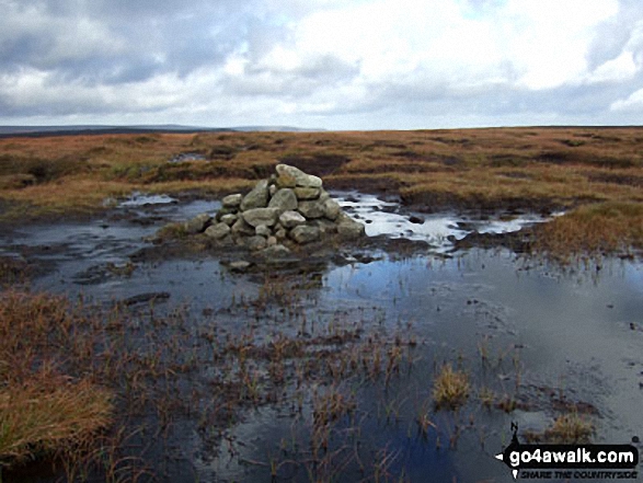 The summit of Kinder Scout in The Dark Peak Area area of The Peak District
Photo: Ben Lockett
# Whether you print a copy or download it to your phone, this Peak Baggers' Map will prove incredibly useful if you want to know what's what when you are up in the mountains and cannot get a phone signal.
Is there a Mountain, Peak, Top or Hill missing from the above google map or list?


