
![]()
Brown Knoll (Edale)
569m (1867ft)
The Dark Peak Area, The Peak District, Derbyshire, England
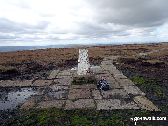
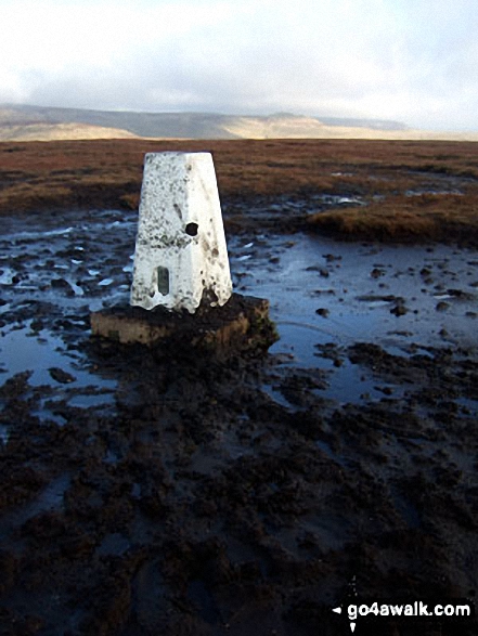
The summit of Brown Knoll (Edale) is marked by an Ordnance Survey Trig Point.
Not familiar with this top?
You can walk/hike to the top of Brown Knoll (Edale) by using any of these 4 easy‑to‑follow route maps:
Walk d254 Brown Knoll (Edale), South Head (Hayfield) and Mount Famine from Bowden Bridge, Hayfield
A steady climb to high level views
   |
|---|
Vital Statistics:
| Length: | 7.5ml (12km) |
|---|---|
| Ascent: | 1,808ft (551m) |
| Time: | 4½ hrs |
| Grade: |  (Moderate) (Moderate) |

Route Summary:
Bowden Bridge - Hayfield - Turnstead House - Coldwell Clough - Oaken Clough - Edale Cross - Brown Knoll (Edale) - South Head (Hayfield) - Mount Famine - Elle Bank - The Pennine Bridleway - Tunstead House - Bowden Bridge - Hayfield
Walk d156 Kinder Low (Kinder Scout), Brown Knoll (Edale), South Head (Hayfield) and Mount Famine from Bowden Bridge, Hayfield
A steady climb to high level views
|
|---|
Vital Statistics:
| Length: | 10.75ml (17km) |
|---|---|
| Ascent: | 2,242ft (683m) |
| Time: | 6.25hrs |
| Grade: |  (Moderate) (Moderate) |

Route Summary:
Bowden Bridge - Hayfield - Booth Sheepwash - Farlands - Broad Clough - Kinderlow End - Three Knolls - Cluther Rocks - Red Brook - The Pennine Way - Kinder Downfall - Kinder Low (Kinder Scout) - Brown Knoll (Edale) - South Head (Hayfield) - Mount Famine - Elle Bank - The Pennine Bridleway - Tunstead House - Hayfield
Walk d162 Brown Knoll (Edale), Lord's Seat (Rushup Edge) and Mam Tor via Jacob's Ladder from Edale
Fine high level walk away from the crowds - can be boggy
|
|---|
Vital Statistics:
| Length: | 10.5ml (17km) |
|---|---|
| Ascent: | 1,986ft (605m) |
| Time: | 5.75hrs |
| Grade: | (Moderate) |

Route Summary:
Edale - The Pennine Way - Upper Booth - Jacob's Ladder (Edale) - Brown Knoll (Edale) - Colborne (Colbourne) - Chapel Gate Track - Lord's Seat (Rushup Edge) - Mam Tor - Hollins Cross - Edale
Walk d214 Mount Famine, South Head and Brown Knoll from Hayfield
Bridget bagging splendour away from the crowds
|
|---|
Vital Statistics:
| Length: | 13.5ml (21.5km) |
|---|---|
| Ascent: | 2,914ft (888m) |
| Time: | 7.75hrs |
| Grade: |  (Hard) (Hard) |
Route Summary:
Hayfield - Sett Valley Trail - Birch Vale - Morland Road - Ollersett - New Allotments - Chinley Head - Mount Famine - South Head (Hayfield) - Brown Knoll (Edale) - Edale Cross - Oaken Clough - Coldwell Clough - Tunstead House - Bowden Bridge - Hayfield
See Brown Knoll (Edale) and the surrounding tops on our free-to-access 'Google Style' Peak Bagging Maps:
The Dark Peak Area of The Peak District National Park
Less data - quicker to download
See Brown Knoll (Edale) and the surrounding tops on our unique, downloadable, PDF Peak Bagging Map:

NB: Whether you print off a copy or download it to your phone, this PDF Peak Baggers' Map might prove incredibly useful when your are up there on the tops and you cannot get a phone signal.
You can find Brown Knoll (Edale) & all the walks that climb it on these unique free-to-access Interactive Walk Planning Maps:
1:25,000 scale OS Explorer Map (orange/yellow covers):
1:50,000 scale OS Landranger Map (pink/magenta covers):
 Fellow go4awalkers who have already walked, climbed, scaled, summited, hiked & bagged Brown Knoll (Edale)
hannah1507 walked up Brown Knoll (Edale) on April 7th, 2023 [from/via/route] d162 Brown Knoll (Edale), Lord's Seat (Rushup Edge) & Mam Tor via Jacob's Ladder from Edale [with] Solo
Patrick Molloy climbed it on November 22nd, 2021 [from/via/route] Solo from Mam Tor Car Park. via Lord's Seat [with] Solo [weather] Cold Clear
Jim Sallis bagged it on April 12th, 2021 [weather] Snowed previous day
Tony Halliday hiked Brown Knoll (Edale) on April 3rd, 2021 [from/via/route] started from edale up Jacobs ladder onto brown knoll lords seat the ridge walk mam tor back tor & lose hill [with] jimmy my boarder terrier [weather] bit of cloud with sunny spells cold start warmed up as day went on - great walk from edale great views & perfect weather
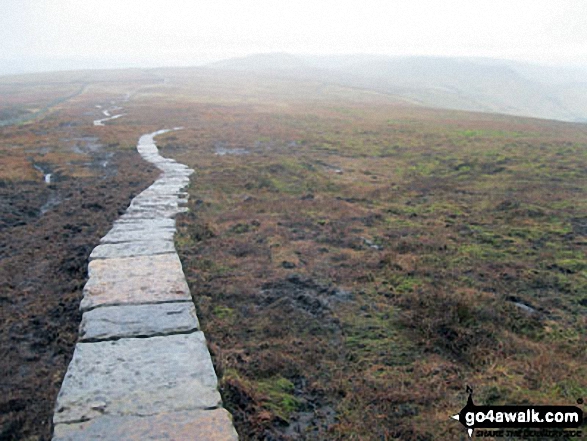
Christine Shepherd summited on March 24th, 2019 [from/via/route] Walked from Bowden Bridge using walk d254. [with] On my own [weather] Bright & dry with a very cold wind. - A lovely walk. The path to the trig point on Brown Knoll is now paved. Don't step off the paving slabs to take a picture though!
To add (or remove) your name and experiences on this page - Log On and edit your Personal Mountain Bagging Record
. . . [see more walk reports]
More Photographs & Pictures of views from, on, or of, Brown Knoll (Edale)


Send us your photographs and pictures on, of, or from Brown Knoll (Edale)
If you would like to add your walk photographs and pictures to this page, please send them as email attachments (configured for any computer) along with your name to:
and we shall do our best to publish them.
(Guide Resolution = 300dpi. At least = 660pixels (wide) x 440 pixels (high).)

You can also submit photos via our Facebook Page.
NB. Please indicate where each photo was taken and whether you wish us to credit your photos with a Username or your First Name/Last Name.


