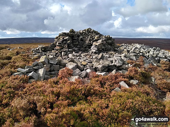
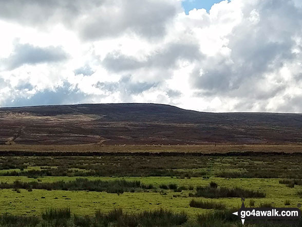
Bridget Icon

Pike Lowe
478m (1569ft)


The Dark Peak Area, The Peak District, South Yorkshire, England


Record Pike Lowe as Bagged, Climbed & Conquered

Walk Pike Lowe walking UK Mountains in The Dark Peak Area The Peak District National Park South Yorkshiren, England

Pike Lowe Summit

Photo: David Erskine


Not familiar with this top?

How is Pike Lowe classified?

Download 1 easy-to-follow, circular walk that include Pike Lowe

See the location of Pike Lowe and the walk on an interactive Google Map

See the location of Pike Lowe on an interactive Google Bagging Map

See the location of Pike Lowe and the walk on our unique free-to-access Interactive Walk Planning Maps (worth a look if you've never seen these)

See downloadable Bagging Map in PDF format that includes Pike Lowe

Read walk reports from hikers who have already bagged Pike Lowe

View more photographs & pictures of views from, on or of Pike Lowe


You can walk to the top of Pike Lowe by using this easy‑to‑follow route map:
Walking Boot Print Icon

Walk sy102 Pike Lowe from Langsett Barn

Walk GPS Icon
Walk GPX Icon
Walk PDF Icon

Vital Statistics:

Length: 7.5mls (12km)
Ascent:1,118ft (360m)
Time:4 hrs
Grade:Walk Grade 4 Icon (Moderate)

See Pike Lowe and the surrounding tops on our free-to-access 'Google Style' Peak Bagging Maps:

Find Google Maps Peak Bagging Map Icon

The Dark Peak Area of The Peak District National Park
Less data - quicker to download

Find Google Maps Peak Bagging Map Icon

The Peak District National Park
More data - might take a little longer to download


See Pike Lowe and the surrounding tops on our downloadable Peak Bagging Map in PDF format:

Find PDF Peak Bagging Map Icon

-The Dark Peak Area of The Peak District National Park

NB: Whether you print off a copy or download it to your phone, this PDF Peak Baggers' Map might prove incredibly useful when your are up there on the tops and you cannot get a phone signal.


You can find Pike Lowe & all the walks that climb it on these unique free-to-access Interactive Walk Planning Maps:

The Peak District National Park


1:25,000 scale OS Explorer Map (orange/yellow covers):

OS Explorer OL1 The Peak District - Dark Peak area


1:50,000 scale OS Landranger Map (pink/magenta covers):

OS Landranger 110 Sheffield & Huddersfield, Glossop & Holmfirth


Top


Other walkers who hiked, climbed, bagged and summited Pike Lowe Fellow go4awalkers who have already walked, climbed, summited & bagged Pike Lowe

Mark Davidson walked up Pike Lowe on October 15th, 2020 [from/via/route] Langsett Reservoir [with] Alone [weather] Bit cold & grey - shower came through on the way down - Second attempt at bagging this after being thwarted by a grouse shoot the week before

John Gehrke climbed Pike Lowe on October 3rd, 2013 [from/via/route] from Langsett [with] solo [weather] very wet & misty - next to no visibility for most of the walk & saw pretty much only rain & clouds but it was still really good to get out; glad that I got to the path before I had to start using the torch as it would have been such a pain crossing the open boggy ground otherwise!

To add (or remove) your name and experiences on this page - Log On and edit your Personal Mountain Bagging Record

Top


More Photographs & Pictures of views from, on or of Pike Lowe

Pike Lowe from Upper Midhope

Pike Lowe from Upper Midhope

Photo: David Erskine (24)

Top


Send us your photographs and pictures on, of, or from Pike Lowe

If you would like to add your walk photographs and pictures featuring views from, on or of Pike Lowe to this page, please send them as email attachments (configured for any computer) along with your name to:


and we shall do our best to publish them.

(Guide Resolution = 300dpi. At least = 660pixels (wide) x 440 pixels (high).)

Send us your photographs and pictures on, of, or from Pike Lowe via Facebook

You can also submit photos via our Facebook Page.

NB. Please indicate where each photo was taken and whether you wish us to credit your photos with a Username or your First Name/Last Name.

Top


Not familiar with this top?

How is Pike Lowe classified?

Download 1 easy-to-follow, circular walk that include Pike Lowe

See the location of Pike Lowe and the walk on an interactive Google Map

See the location of Pike Lowe on an interactive Google Bagging Map

See the location of Pike Lowe and the walk on our unique free-to-access Interactive Walk Planning Maps (worth a look if you've never seen these)

See downloadable Bagging Map in PDF format that includes Pike Lowe

Read walk reports from hikers who have already bagged Pike Lowe

View more photographs & pictures of views from, on or of Pike Lowe


Follow go4awalk.com on Twitter Follow go4awalk.com on Facebook


Home


Find new Friends to go walking with

Walk all 214 Wainwrights in just 59 Walks. Download GPS Waypoints - Great Walks you must not miss!

Walk The Yorkshire Three Peaks Challenge Walk - All the Latest Route Information, GPS Waypoints and Split Times to keep you on Schedule

Walk The British Three Peaks Challenge Walk - All the Latest Route Information and GPS Waypoints

See our pick of The Best Walks in The Lake District - Great Walks you must not miss!

Walk our pick of the Best Lake District Ridge Walks - Great Walks you must not miss!

Walk our pick of the Best Lake District Walks to do in the rain - Great Walks you must not miss!

Walk our pick of The Best Walks in Snowdonia - Great Walks you must not miss!

Walk our pick of The Best Ridge Walks in Wales - Walks you must not miss!

Walk our pick of The Best Walks in The Brecon Beacons - Great Walks you must not miss!

Walk our pick of The Best Walks in The Yorkshire Dales - Walks you must not miss!

Walk our pick of The Best Walks in The Peak District - Walks you must not miss!

Walk our pick of The Best Walks in The Forest of Bowland - Walks you must not miss!

Walk our pick of The Best Walks in Shropshire - Walks you must not miss!

Walk our pick of The Best Walks in Cheshire - Walks you must not miss!

Walk our pick of The Best Walks in Lancashire - Walks you must not miss!

Not sure where to walk next? Try Peak Bagging - Great Walks you must not miss!

Not sure where to walk next? Walk part of a National Trail - Great Walks you must not miss!

Walks with Downloadable and Uploadable GPS Waypoint Data

Walking Kit and Gear Tested by Walkers

Full Site Search