The Mountains, Peaks, Tops and Hills in the West Midlands region of England in Alphabetical Order
The West Midlands region of England comprises the traditional counties of Herefordshire, Shropshire, Staffordshire, Warwickshire, West Midlands, Worcestershire and parts of the Peak District National Park.
If you include all the Mountains (Hewitts), the Deweys, the Nuttalls, the Marilyns, the Bridgets (Hills) and all the Mountains, Tops, Peaks and Hills with a Trig Point on them there are 176 tops to climb, bag & conquer and the highest point is Black Hill (Craswall) at 641m (2,103ft).
To see these Mountains, Peaks, Tops and Hills displayed in different ways - see the options in the left-hand column and towards the bottom of this page.
![]() Your Personal Bagging Record for West Midlands of
Your Personal Bagging Record for West Midlands of
When logged on, you can mark each Mountain, Peak, Top or Hill as 'bagged' by either:
- if you opt to display the tops in this area using a google map, click or tap on its symbol on the map below. This will open a text window. Click or tap on the 'Record [mountain name] as Bagged, Climbed & Conquered' link towards the bottom of the text window, or
- if you opt to display the tops in this area as a list, click or tap on the red 'not yet' symbol to the right of the name of each 'top'
Either method will open a new page where you can complete all your details such as:
- when you bagged the Mountain, Peak, Top or Hill;
- which route you took
- who you went with
- what the weather was like
- any other comment that will remind you of the day
Once you have completed your details and click or tap the submit button, you will automatically return to this page and the top you bagged will show with a green tick.
NB. None of the above fields are 'mandatory' - you can leave them blank if you wish.
NNB. You also have the option whether to display your peak bagging exploits to other users of this site or keep them private so only you can see them when you are logged on.
Furthermore, since you can also access your Personal Mountain & Hill Bagging Record via go4awalk Mobile you can quickly & easily record, edit and view your achievements - whether you are at home/work on your desktop computer or in the pub/at the top of a mountain with your Mobile Phone. (You can even download your Personal Mountain & Hill Bagging Record as a .csv file for importing into and saving with spreadsheet software like Excel or NeoOffice!)
This facility costs one credit to initially access your personal bagging record. Once accessed, all other interactions, such as recording other Mountains, Peaks, Tops and Hills as 'bagged' or altering an existing bagging record, are free.
Click REGISTER to register and purchase credits.
LOG ON and RELOAD this page to show which Mountains, Peaks, Tops and Hills you have already climbed, bagged & conquered. [ . . . remove this text]
NB. If a Google Map does not appear below, or the icons do not respond, click here to refresh the page. If that doesn't work, try deleting your browser's cache.
Scroll down this list of mountains, peaks, tops & hills below and tap/click on each name (in blue) to locate it's position on the map above.
See this list in: Alphabetical Order‡ | Height Order
To reverse the order select the link again.
Mountain, Peak, Top or Hill:
Bagged

![]()
1. Abberley Hill (Flagstaff Wood)
285m (935ft)
Bridget and Trig Point
See more details, photos, trip reports and easy-to-follow walks up Abberley Hill (Flagstaff Wood)

![]()
2. Aconbury Hill (Aconbury Camp)
276m (905ft)
Marilyn and Trig Point
See more details, photos, trip reports and easy-to-follow walks up Aconbury Hill (Aconbury Camp)

![]()
3. Adstone Hill
369m (1,211ft)
Bridget
See more details, photos, trip reports and easy-to-follow walks up Adstone Hill
![]()
4. Alport Height
314m (1,030ft)
Bridget and Trig Point
See more details, photos, trip reports and easy-to-follow walks up Alport Height
![]()
5. Anthony Hill
293m (961ft)
Bridget
See more details, photos, trip reports and easy-to-follow walks up Anthony Hill

![]()
6. Axe Edge (Axe Edge Moor)
551m (1,808ft)
Dewey and Trig Point
See more details, photos, trip reports and easy-to-follow walks up Axe Edge (Axe Edge Moor)
![]()
7. Beeley Moor
371m (1,217ft)
Bridget
See more details, photos, trip reports and easy-to-follow walks up Beeley Moor

![]()
8. Beeley Moor (South East Top)
367m (1,204ft)
Trig Point
See more details, photos, trip reports and easy-to-follow walks up Beeley Moor (South East Top)
![]()
9. Berrow Hill
178m (584ft)
Bridget and Trig Point
See more details, photos, trip reports and easy-to-follow walks up Berrow Hill
![]()
10. Birley Hill
236m (774ft)
Bridget and Trig Point
See more details, photos, trip reports and easy-to-follow walks up Birley Hill
![]()
11. Black Edge (Combs Moss)
507m (1,663ft)
Dewey and Trig Point
See more details, photos, trip reports and easy-to-follow walks up Black Edge (Combs Moss)
![]()
12. Black Hill (Clun)
441m (1,447ft)
Bridget and Trig Point
See more details, photos, trip reports and easy-to-follow walks up Black Hill (Clun)
![]()
13. Black Hill (Craswall)
641m (2,103ft)
Bridget and Trig Point
See more details, photos, trip reports and easy-to-follow walks up Black Hill (Craswall)
![]()
14. Black Rhadley Hill
401m (1,316ft)
Bridget
See more details, photos, trip reports and easy-to-follow walks up Black Rhadley Hill
![]()
15. Blake Mere (Merryton Low)
489m (1,604ft)
Bridget and Trig Point
See more details, photos, trip reports and easy-to-follow walks up Blake Mere (Merryton Low)

![]()
16. Bleaklow Head (Bleaklow Hill)
633m (2,077ft)
Mountain (Hewitt) and Nuttall
See more details, photos, trip reports and easy-to-follow walks up Bleaklow Head (Bleaklow Hill)
![]()
17. Bolehill (Wirksworth)
322m (1,056ft)
Bridget and Trig Point
See more details, photos, trip reports and easy-to-follow walks up Bolehill (Wirksworth)
![]()
18. Bradlow Knoll
237m (777ft)
Bridget
See more details, photos, trip reports and easy-to-follow walks up Bradlow Knoll

![]()
19. Bradnor Hill
391m (1,283ft)
Marilyn
See more details, photos, trip reports and easy-to-follow walks up Bradnor Hill
![]()
20. Bradwell Moor
471m (1,545ft)
Bridget and Trig Point
See more details, photos, trip reports and easy-to-follow walks up Bradwell Moor
![]()
21. Bredon Hill
299m (981ft)
Marilyn
See more details, photos, trip reports and easy-to-follow walks up Bredon Hill
![]()
22. Bringewood
363m (1,191ft)
Bridget and Trig Point
See more details, photos, trip reports and easy-to-follow walks up Bringewood
![]()
23. Broad Heath
245m (804ft)
Bridget and Trig Point
See more details, photos, trip reports and easy-to-follow walks up Broad Heath

![]()
24. Brown Clee Hill (Abdon Burf)
540m (1,772ft)
Dewey, Marilyn and Trig Point
See more details, photos, trip reports and easy-to-follow walks up Brown Clee Hill (Abdon Burf)

![]()
25. Brown Clee Hill (Clee Burf)
508m (1,667ft)
Dewey
See more details, photos, trip reports and easy-to-follow walks up Brown Clee Hill (Clee Burf)
![]()
26. Brown Knoll (Edale)
569m (1,867ft)
Dewey and Trig Point
See more details, photos, trip reports and easy-to-follow walks up Brown Knoll (Edale)
![]()
27. Bryn Hill
408m (1,339ft)
Bridget
See more details, photos, trip reports and easy-to-follow walks up Bryn Hill
![]()
28. Bucknell Hill
361m (1,184ft)
Bridget
See more details, photos, trip reports and easy-to-follow walks up Bucknell Hill
![]()
29. Bucknell Wood
394m (1,293ft)
Bridget
See more details, photos, trip reports and easy-to-follow walks up Bucknell Wood
![]()
30. Burbage Edge
500m (1,641ft)
Bridget and Trig Point
See more details, photos, trip reports and easy-to-follow walks up Burbage Edge
![]()
31. Burrow (Shropshire)
358m (1,174ft)
Marilyn
See more details, photos, trip reports and easy-to-follow walks up Burrow (Shropshire)
![]()
32. Burton Hill
294m (964ft)
Marilyn and Trig Point
See more details, photos, trip reports and easy-to-follow walks up Burton Hill
![]()
33. Buxton Wood
345m (1,132ft)
Bridget
See more details, photos, trip reports and easy-to-follow walks up Buxton Wood
![]()
34. Caer Caradoc (Knighton)
399m (1,309ft)
Bridget
See more details, photos, trip reports and easy-to-follow walks up Caer Caradoc (Knighton)
![]()
35. Caer Caradoc Hill
459m (1,506ft)
Marilyn
See more details, photos, trip reports and easy-to-follow walks up Caer Caradoc Hill
![]()
36. Callow
411m (1,348ft)
Bridget
See more details, photos, trip reports and easy-to-follow walks up Callow
![]()
37. Callow Hill (Little Stretton)
336m (1,102ft)
Marilyn and Trig Point
See more details, photos, trip reports and easy-to-follow walks up Callow Hill (Little Stretton)
![]()
38. Calton Pastures
289m (948ft)
Bridget and Trig Point
See more details, photos, trip reports and easy-to-follow walks up Calton Pastures
![]()
39. Carder Low
380m (1,247ft)
Bridget
See more details, photos, trip reports and easy-to-follow walks up Carder Low
![]()
40. Cefn Gunthly
402m (1,319ft)
Bridget
See more details, photos, trip reports and easy-to-follow walks up Cefn Gunthly
![]()
41. Cefn Hepreas
412m (1,352ft)
Bridget
See more details, photos, trip reports and easy-to-follow walks up Cefn Hepreas
![]()
42. Chase Hill
203m (666ft)
Bridget and Trig Point
See more details, photos, trip reports and easy-to-follow walks up Chase Hill
![]()
43. Cheeks Hill
520m (1,707ft)
Bridget
See more details, photos, trip reports and easy-to-follow walks up Cheeks Hill
![]()
44. Chinley Churn
451m (1,480ft)
Bridget and Trig Point
See more details, photos, trip reports and easy-to-follow walks up Chinley Churn
![]()
45. Chrome Hill
423m (1,388ft)
Bridget
See more details, photos, trip reports and easy-to-follow walks up Chrome Hill
![]()
46. Clun Hill
394m (1,293ft)
Bridget
See more details, photos, trip reports and easy-to-follow walks up Clun Hill
![]()
47. Clunbury Hill
304m (997ft)
Bridget
See more details, photos, trip reports and easy-to-follow walks up Clunbury Hill
![]()
48. Cobden Edge
327m (1,073ft)
Bridget and Trig Point
See more details, photos, trip reports and easy-to-follow walks up Cobden Edge
![]()
49. Cold Overton Park
197m (646ft)
Bridget and Trig Point
See more details, photos, trip reports and easy-to-follow walks up Cold Overton Park
![]()
50. Colebatch Hill
416m (1,365ft)
Bridget and Trig Point
See more details, photos, trip reports and easy-to-follow walks up Colebatch Hill
![]()
51. Combs Head (Combs Moss)
503m (1,650ft)
Dewey
See more details, photos, trip reports and easy-to-follow walks up Combs Head (Combs Moss)
![]()
52. Coppet Hill
200m (656ft)
Bridget and Trig Point
See more details, photos, trip reports and easy-to-follow walks up Coppet Hill
![]()
53. Cothercott Hill
442m (1,450ft)
Bridget
See more details, photos, trip reports and easy-to-follow walks up Cothercott Hill
![]()
54. Cown Edge Rocks
410m (1,345ft)
Bridget and Trig Point
See more details, photos, trip reports and easy-to-follow walks up Cown Edge Rocks
![]()
55. Coxall Knoll
262m (859ft)
Bridget
See more details, photos, trip reports and easy-to-follow walks up Coxall Knoll
![]()
56. Craig-y-rhiw
362m (1,188ft)
Bridget
See more details, photos, trip reports and easy-to-follow walks up Craig-y-rhiw
![]()
57. Credenhill
221m (725ft)
Bridget
See more details, photos, trip reports and easy-to-follow walks up Credenhill
![]()
58. Croft Ambrey
306m (1,004ft)
Bridget
See more details, photos, trip reports and easy-to-follow walks up Croft Ambrey
![]()
59. Cwm-sanaham Hill
409m (1,342ft)
Bridget and Trig Point
See more details, photos, trip reports and easy-to-follow walks up Cwm-sanaham Hill
![]()
60. Dead Edge End
499m (1,637ft)
Bridget and Trig Point
See more details, photos, trip reports and easy-to-follow walks up Dead Edge End
![]()
61. Diddlebury Common
317m (1,040ft)
Bridget
See more details, photos, trip reports and easy-to-follow walks up Diddlebury Common
![]()
62. Dowke Hill
416m (1,365ft)
Bridget
See more details, photos, trip reports and easy-to-follow walks up Dowke Hill
![]()
63. Earl's Hill
320m (1,050ft)
Bridget and Trig Point
See more details, photos, trip reports and easy-to-follow walks up Earl's Hill
![]()
64. Eccles Pike
370m (1,214ft)
Bridget
See more details, photos, trip reports and easy-to-follow walks up Eccles Pike
![]()
65. Ecton Hill
369m (1,211ft)
Bridget and Trig Point
See more details, photos, trip reports and easy-to-follow walks up Ecton Hill
![]()
66. Eldon Hill (Perryfoot)
470m (1,542ft)
Bridget
See more details, photos, trip reports and easy-to-follow walks up Eldon Hill (Perryfoot)
![]()
67. Featherbed Moss (Chew Reservoir)
541m (1,775ft)
Bridget and Trig Point
See more details, photos, trip reports and easy-to-follow walks up Featherbed Moss (Chew Reservoir)
![]()
68. Featherbed Top (Featherbed Moss)
544m (1,785ft)
Dewey
See more details, photos, trip reports and easy-to-follow walks up Featherbed Top (Featherbed Moss)
![]()
69. Fin Cop
327m (1,073ft)
Bridget
See more details, photos, trip reports and easy-to-follow walks up Fin Cop
![]()
70. Garnons Hill
238m (781ft)
Bridget
See more details, photos, trip reports and easy-to-follow walks up Garnons Hill
![]()
71. Garway Hill
366m (1,201ft)
Marilyn and Trig Point
See more details, photos, trip reports and easy-to-follow walks up Garway Hill
![]()
72. Gatley Hill
338m (1,109ft)
Bridget
See more details, photos, trip reports and easy-to-follow walks up Gatley Hill
![]()
73. Graig Hill
371m (1,217ft)
Bridget
See more details, photos, trip reports and easy-to-follow walks up Graig Hill
![]()
74. Gratton Hill
363m (1,191ft)
Bridget
See more details, photos, trip reports and easy-to-follow walks up Gratton Hill
![]()
75. Grendon Green (Batchley Farm)
252m (827ft)
Trig Point
See more details, photos, trip reports and easy-to-follow walks up Grendon Green (Batchley Farm)
![]()
76. Grindle
459m (1,506ft)
Bridget
See more details, photos, trip reports and easy-to-follow walks up Grindle
![]()
77. Grindon Moor (Grindon Moor)
377m (1,237ft)
Bridget and Trig Point
See more details, photos, trip reports and easy-to-follow walks up Grindon Moor (Grindon Moor)
![]()
78. Grinshill Hill
192m (630ft)
Bridget and Trig Point
See more details, photos, trip reports and easy-to-follow walks up Grinshill Hill
![]()
79. Gun (Staffordshire)
385m (1,264ft)
Marilyn and Trig Point
See more details, photos, trip reports and easy-to-follow walks up Gun (Staffordshire)
![]()
80. Harboro' Rocks
379m (1,243ft)
Bridget and Trig Point
See more details, photos, trip reports and easy-to-follow walks up Harboro' Rocks
![]()
81. Haven Hill
276m (905ft)
Bridget
See more details, photos, trip reports and easy-to-follow walks up Haven Hill
![]()
82. Hawkstone Hill
208m (682ft)
Bridget
See more details, photos, trip reports and easy-to-follow walks up Hawkstone Hill
![]()
83. Hazler Hill
347m (1,138ft)
Bridget and Trig Point
See more details, photos, trip reports and easy-to-follow walks up Hazler Hill
![]()
84. Heath Mynd
452m (1,483ft)
Marilyn and Trig Point
See more details, photos, trip reports and easy-to-follow walks up Heath Mynd
![]()
85. Hegdon Hill (Lower Hegdon)
254m (833ft)
Marilyn and Trig Point
See more details, photos, trip reports and easy-to-follow walks up Hegdon Hill (Lower Hegdon)
![]()
86. Helmeth Hill
344m (1,129ft)
Bridget
See more details, photos, trip reports and easy-to-follow walks up Helmeth Hill
![]()
87. Herefordshire Beacon
338m (1,109ft)
Bridget
See more details, photos, trip reports and easy-to-follow walks up Herefordshire Beacon
![]()
88. Hergest Ridge
426m (1,398ft)
Marilyn and Trig Point
See more details, photos, trip reports and easy-to-follow walks up Hergest Ridge
![]()
89. Higger Tor
434m (1,424ft)
Bridget
See more details, photos, trip reports and easy-to-follow walks up Higger Tor
![]()
90. High Bent (Biddulph Moor)
336m (1,102ft)
Bridget and Trig Point
See more details, photos, trip reports and easy-to-follow walks up High Bent (Biddulph Moor)
![]()
91. High Vinnalls
375m (1,230ft)
Marilyn
See more details, photos, trip reports and easy-to-follow walks up High Vinnalls

![]()
92. Higher Shelf Stones
622m (2,041ft)
Nuttall and Trig Point
See more details, photos, trip reports and easy-to-follow walks up Higher Shelf Stones
![]()
93. Hill End (Cardington)
294m (964ft)
Bridget
See more details, photos, trip reports and easy-to-follow walks up Hill End (Cardington)
![]()
94. Hill House
425m (1,395ft)
Bridget and Trig Point
See more details, photos, trip reports and easy-to-follow walks up Hill House
![]()
95. Hitter Hill
362m (1,188ft)
Bridget
See more details, photos, trip reports and easy-to-follow walks up Hitter Hill
![]()
96. Hollins Hill
451m (1,480ft)
Bridget
See more details, photos, trip reports and easy-to-follow walks up Hollins Hill
![]()
97. Hope Bowdler Hill
426m (1,398ft)
Bridget
See more details, photos, trip reports and easy-to-follow walks up Hope Bowdler Hill
![]()
98. Hopesay Hill
284m (932ft)
Bridget
See more details, photos, trip reports and easy-to-follow walks up Hopesay Hill
![]()
99. Hopton Titterhill
397m (1,302ft)
Bridget
See more details, photos, trip reports and easy-to-follow walks up Hopton Titterhill
![]()
100. Huglith Hill
328m (1,076ft)
Bridget
See more details, photos, trip reports and easy-to-follow walks up Huglith Hill
![]()
101. Ilmington Down
261m (856ft)
Bridget and Trig Point
See more details, photos, trip reports and easy-to-follow walks up Ilmington Down
![]()
102. Kenslow Knoll
337m (1,106ft)
Bridget
See more details, photos, trip reports and easy-to-follow walks up Kenslow Knoll
![]()
103. Kinder Low (Kinder Scout)
633m (2,078ft)
Bridget and Trig Point
See more details, photos, trip reports and easy-to-follow walks up Kinder Low (Kinder Scout)
![]()
104. Knoll Hill
287m (941ft)
Bridget
See more details, photos, trip reports and easy-to-follow walks up Knoll Hill
![]()
105. Knolls
456m (1,496ft)
Bridget and Trig Point
See more details, photos, trip reports and easy-to-follow walks up Knolls
![]()
106. Lilywood (Wenlock Edge)
287m (941ft)
Bridget
See more details, photos, trip reports and easy-to-follow walks up Lilywood (Wenlock Edge)
![]()
107. Little Doward
221m (725ft)
Bridget and Trig Point
See more details, photos, trip reports and easy-to-follow walks up Little Doward
![]()
108. Little London (Middlehope Hill)
324m (1,063ft)
Bridget and Trig Point
See more details, photos, trip reports and easy-to-follow walks up Little London (Middlehope Hill)
![]()
109. Llanfair Hill
432m (1,417ft)
Bridget
See more details, photos, trip reports and easy-to-follow walks up Llanfair Hill
![]()
110. Lodge Hill (Causeway Wood)
304m (997ft)
Bridget and Trig Point
See more details, photos, trip reports and easy-to-follow walks up Lodge Hill (Causeway Wood)
![]()
111. Longstone Moor
395m (1,296ft)
Bridget
See more details, photos, trip reports and easy-to-follow walks up Longstone Moor
![]()
112. Lord's Seat (Rushup Edge)
546m (1,791ft)
Dewey
See more details, photos, trip reports and easy-to-follow walks up Lord's Seat (Rushup Edge)
![]()
113. Lordshill
364m (1,194ft)
Bridget
See more details, photos, trip reports and easy-to-follow walks up Lordshill
![]()
114. Lynchgate (Edgton Hill)
297m (974ft)
Bridget
See more details, photos, trip reports and easy-to-follow walks up Lynchgate (Edgton Hill)
![]()
115. Malvern (Worcestershire Beacon)
425m (1,395ft)
Marilyn and Trig Point
See more details, photos, trip reports and easy-to-follow walks up Malvern (Worcestershire Beacon)
![]()
116. Mam Tor
517m (1,696ft)
Dewey and Trig Point
See more details, photos, trip reports and easy-to-follow walks up Mam Tor
![]()
117. Masson Hill (Heights of Abraham)
338m (1,109ft)
Bridget and Trig Point
See more details, photos, trip reports and easy-to-follow walks up Masson Hill (Heights of Abraham)
![]()
118. Merbach Hill
318m (1,043ft)
Bridget and Trig Point
See more details, photos, trip reports and easy-to-follow walks up Merbach Hill
![]()
119. Mere Hill
258m (846ft)
Bridget
See more details, photos, trip reports and easy-to-follow walks up Mere Hill
![]()
120. Mill Hill (Ashop Head)
544m (1,785ft)
Dewey
See more details, photos, trip reports and easy-to-follow walks up Mill Hill (Ashop Head)
![]()
121. Mogg Forest
289m (948ft)
Bridget and Trig Point
See more details, photos, trip reports and easy-to-follow walks up Mogg Forest
![]()
122. Mucklewick Hill
371m (1,217ft)
Bridget
See more details, photos, trip reports and easy-to-follow walks up Mucklewick Hill
![]()
123. Narrowdale Hill
367m (1,204ft)
Bridget
See more details, photos, trip reports and easy-to-follow walks up Narrowdale Hill
![]()
124. Nelson's Monument (Birchen Edge)
302m (991ft)
Bridget and Trig Point
See more details, photos, trip reports and easy-to-follow walks up Nelson's Monument (Birchen Edge)
![]()
125. Nick Knolls
374m (1,227ft)
Bridget
See more details, photos, trip reports and easy-to-follow walks up Nick Knolls
![]()
126. Norbury Hill (Linley Hill)
411m (1,348ft)
Bridget
See more details, photos, trip reports and easy-to-follow walks up Norbury Hill (Linley Hill)
![]()
127. Norton Camp
294m (964ft)
Bridget
See more details, photos, trip reports and easy-to-follow walks up Norton Camp
![]()
128. Nover's Hill
305m (1,001ft)
Bridget
See more details, photos, trip reports and easy-to-follow walks up Nover's Hill
![]()
129. Oakeley Mynd
309m (1,014ft)
Bridget and Trig Point
See more details, photos, trip reports and easy-to-follow walks up Oakeley Mynd
![]()
130. Oaker Wood
243m (797ft)
Bridget
See more details, photos, trip reports and easy-to-follow walks up Oaker Wood
![]()
131. Oliver Hill
513m (1,684ft)
Dewey
See more details, photos, trip reports and easy-to-follow walks up Oliver Hill
![]()
132. Overmoor
288m (945ft)
Bridget
See more details, photos, trip reports and easy-to-follow walks up Overmoor
![]()
133. Parkhouse Hill
352m (1,155ft)
Bridget
See more details, photos, trip reports and easy-to-follow walks up Parkhouse Hill
![]()
134. Pole Bank (Long Mynd)
516m (1,693ft)
Dewey, Marilyn and Trig Point
See more details, photos, trip reports and easy-to-follow walks up Pole Bank (Long Mynd)
![]()
135. Pole Wood
302m (991ft)
Bridget
See more details, photos, trip reports and easy-to-follow walks up Pole Wood
![]()
136. Radnor Wood
325m (1,066ft)
Bridget
See more details, photos, trip reports and easy-to-follow walks up Radnor Wood
![]()
137. Ragleth Hill
398m (1,306ft)
Bridget
See more details, photos, trip reports and easy-to-follow walks up Ragleth Hill
![]()
138. Revidge
401m (1,316ft)
Bridget and Trig Point
See more details, photos, trip reports and easy-to-follow walks up Revidge
![]()
139. Roman Bank
279m (915ft)
Bridget
See more details, photos, trip reports and easy-to-follow walks up Roman Bank
![]()
140. Roveries Wood
262m (859ft)
Bridget
See more details, photos, trip reports and easy-to-follow walks up Roveries Wood
![]()
141. Seager Hill (Bunker's Hill)
272m (892ft)
Marilyn and Trig Point
See more details, photos, trip reports and easy-to-follow walks up Seager Hill (Bunker's Hill)
![]()
142. Sheen Hill
380m (1,247ft)
Bridget and Trig Point
See more details, photos, trip reports and easy-to-follow walks up Sheen Hill
![]()
143. Shelve Hill
381m (1,250ft)
Bridget
See more details, photos, trip reports and easy-to-follow walks up Shelve Hill
![]()
144. Shobdon Hill
326m (1,069ft)
Marilyn and Trig Point
See more details, photos, trip reports and easy-to-follow walks up Shobdon Hill
![]()
145. Short Wood
313m (1,027ft)
Bridget
See more details, photos, trip reports and easy-to-follow walks up Short Wood
![]()
146. Sir William Hill
429m (1,407ft)
Bridget and Trig Point
See more details, photos, trip reports and easy-to-follow walks up Sir William Hill
![]()
147. Stanton Moor
323m (1,060ft)
Bridget and Trig Point
See more details, photos, trip reports and easy-to-follow walks up Stanton Moor
![]()
148. Stapeley Hill
403m (1,322ft)
Bridget
See more details, photos, trip reports and easy-to-follow walks up Stapeley Hill
![]()
149. Stiperstones (Manstone Rock)
536m (1,759ft)
Dewey, Marilyn and Trig Point
See more details, photos, trip reports and easy-to-follow walks up Stiperstones (Manstone Rock)
![]()
150. Stow Hill
441m (1,447ft)
Bridget and Trig Point
See more details, photos, trip reports and easy-to-follow walks up Stow Hill
![]()
151. Sunnyhill
393m (1,289ft)
Bridget
See more details, photos, trip reports and easy-to-follow walks up Sunnyhill
![]()
152. Switchback Hill
373m (1,224ft)
Bridget
See more details, photos, trip reports and easy-to-follow walks up Switchback Hill
![]()
153. The Edge (Kinder Scout)
624m (2,048ft)
Bridget and Trig Point
See more details, photos, trip reports and easy-to-follow walks up The Edge (Kinder Scout)
![]()
154. The Lawley
377m (1,237ft)
Bridget
See more details, photos, trip reports and easy-to-follow walks up The Lawley
![]()
155. The Wrekin
407m (1,335ft)
Marilyn and Trig Point
See more details, photos, trip reports and easy-to-follow walks up The Wrekin
![]()
156. Thorpe Cloud
287m (941ft)
Bridget
See more details, photos, trip reports and easy-to-follow walks up Thorpe Cloud
![]()
157. Titterstone Clee Hill
533m (1,749ft)
Dewey, Marilyn and Trig Point
See more details, photos, trip reports and easy-to-follow walks up Titterstone Clee Hill
![]()
158. Topley Plantation
301m (987ft)
Bridget
See more details, photos, trip reports and easy-to-follow walks up Topley Plantation
![]()
159. Totley Moor
395m (1,296ft)
Bridget and Trig Point
See more details, photos, trip reports and easy-to-follow walks up Totley Moor
![]()
160. Turner's Hill
271m (889ft)
Bridget
See more details, photos, trip reports and easy-to-follow walks up Turner's Hill
![]()
161. View Edge (Weo Edge)
321m (1,054ft)
Marilyn
See more details, photos, trip reports and easy-to-follow walks up View Edge (Weo Edge)
![]()
162. Walton Hill
316m (1,037ft)
Marilyn and Trig Point
See more details, photos, trip reports and easy-to-follow walks up Walton Hill
![]()
163. Wapley Hill
329m (1,079ft)
Marilyn
See more details, photos, trip reports and easy-to-follow walks up Wapley Hill
![]()
164. Wardlow Hay Cop
370m (1,214ft)
Bridget and Trig Point
See more details, photos, trip reports and easy-to-follow walks up Wardlow Hay Cop
![]()
165. Wart Hill
324m (1,063ft)
Bridget and Trig Point
See more details, photos, trip reports and easy-to-follow walks up Wart Hill
![]()
166. Westend Moor (Alport Moor)
503m (1,650ft)
Bridget and Trig Point
See more details, photos, trip reports and easy-to-follow walks up Westend Moor (Alport Moor)
![]()
167. Wetton Hill
371m (1,217ft)
Bridget
See more details, photos, trip reports and easy-to-follow walks up Wetton Hill
![]()
168. White Edge (Big Moor)
366m (1,201ft)
Bridget and Trig Point
See more details, photos, trip reports and easy-to-follow walks up White Edge (Big Moor)
![]()
169. White Edge (Big Moor) (South East Top)
365m (1,197ft)
Trig Point
![]()
170. White Hill (Herefordshire)
173m (567ft)
Bridget and Trig Point
See more details, photos, trip reports and easy-to-follow walks up White Hill (Herefordshire)
![]()
171. Wigmore Rolls
288m (945ft)
Bridget and Trig Point
See more details, photos, trip reports and easy-to-follow walks up Wigmore Rolls
![]()
172. Windgate Edge
523m (1,716ft)
Bridget
See more details, photos, trip reports and easy-to-follow walks up Windgate Edge
![]()
173. Winhill Pike (Win Hill)
462m (1,516ft)
Bridget and Trig Point
See more details, photos, trip reports and easy-to-follow walks up Winhill Pike (Win Hill)
![]()
174. Wolfscote Hill
388m (1,273ft)
Bridget and Trig Point
See more details, photos, trip reports and easy-to-follow walks up Wolfscote Hill
![]()
175. Wolverton Wood
255m (836ft)
Bridget
See more details, photos, trip reports and easy-to-follow walks up Wolverton Wood
![]()
176. Yearlet
466m (1,529ft)
Bridget
See more details, photos, trip reports and easy-to-follow walks up Yearlet
See this list in: Alphabetical Order‡ | Height Order
To reverse the order select the link again.
View these 176 Mountains, Peaks, Tops and Hills:
- On an Interactive Google Map with a list of tops below it.
(makes it easier to locate a particular top) - On a Detailed List in:
Alphabetical Order | Height Order - On one page with 'yet-to-be-bagged' listed 1st
& then 'already-bagged' tops listed 2nd in:
Alphabetical Order | Height Order - On one page with 'already-bagged' tops listed 1st
& then 'yet-to-be-bagged' tops listed 2nd in:
Alphabetical Order | Height Order
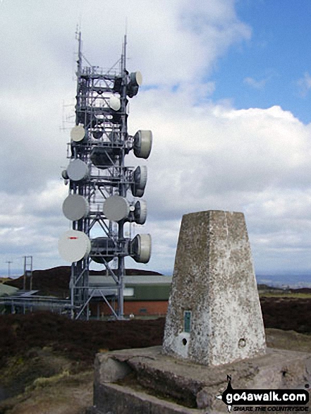 The summit of Brown Clee Hill (Abdon Burf) in West Midlands
Photo: Bruce McDowell
Is there a Mountain, Peak, Top or Hill missing from the above google map or list?
Let us know an we will add it to our database.
To contribute to go4awalk.com or to contact us about anything at all - see Talk To Us.
For help see Help.
go4awalk.com and go4awalk.co.uk are registered trademarks of TMDH Limited.
Copyright © 2000-2026 TMDH Limited. All rights reserved.
Copyright Terms & Conditions Privacy Statement
A - Z Walks Home Log On/Accounts Photo Gallery Walk Ideas and Collections Fell Facts Hill Skills Walking Questions and Answers Your Stories News Competitions Product Reviews/Gear Tests Walking Gear Guides Peaks and Mountains Peak Bagging Find New Walking Friends Camping GPS Waypoints for Walking Contents Walk Search Talk To Us go4awalk.com Help Free Example Walks Newsletter


