46 easy-to-follow circular walk route maps of all grades in The Eastern Fells area of The Lake District
Forty-six easy-to-follow, hand-crafted walks including routes from Aira Force, Ambleside, Brothers Water, Dockray, Glenridding, Grasmere, Kentmere, Patterdale & Thirlmere that climb Helvellyn (the highest point), St Sunday Crag, Great Rigg, Fairfield, Raise, Watson's Dodd, Catstye Cam & High Rigg amongst many others. More details about each walk can be found below the map.
The Eastern Fells area of The Lake District National Park is enclosed by:
- Threlkeld and Pooley Bridge to the North
- Grasmere and Thirlmere to the West
- Ambleside to the South
- The Kirkstone Pass and Ullswater to the East
Tap/mouse over a coloured circle (1-3 easy walks, 4-6 moderate walks, 7-9 hard walks) and click to select.
You can use these checkboxes to show only the grades of walk you are interested in:-
Scroll down the list of walks below & click on each walk title (in blue) to locate it on the map above.
See this list of walks, routes & maps in:
Grade Order | Length Order | Time Order | Walk Number or Start Location Order
NB. To reverse (toggle) this order, click Grade Order again
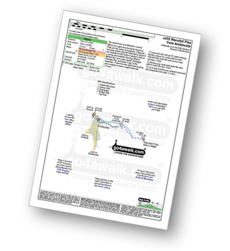
Walk c102 Red Screes from Ambleside
Quieter alternative to the popular routes from Ambleside
   |
Vital Statistics:
| Length: | 7.5 miles (12 km) |
| Ascent: | 2,519ft (768m) |
| Time: | 5.25hrs |
| Grade: |  |
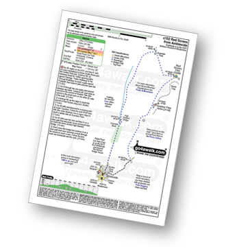
Route Summary:
Ambleside - Snarker Pike - Red Screes - Scandale Pass - High Sweden Bridge - Ambleside
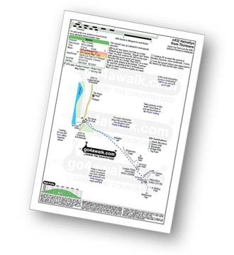
Walk c113 Helvellyn from Thirlmere
Lakeland's most popular mountain
|
Vital Statistics:
| Length: | 8.75 miles (14 km) |
| Ascent: | 3,296ft (1,005m) |
| Time: | 6½ hrs |
| Grade: |  |
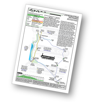
Route Summary:
The Swirls Car Park Thirlmere - Browncove Crags - Lower Man (Helvellyn) - Helvellyn - White Side - Raise (Helvellyn) - Sticks Pass - Sticks Gill - Stanah Gill - Legburthwaite - Thirlmere - Thirlspot - The Swirls Car Park Thirlmere.
Walk c124 Helvellyn Ridge from Thirlmere
Lakeland's most popular mountain with a fine ridge walk
|
Vital Statistics:
| Length: | 10.5 miles (17 km) |
| Ascent: | 3,575ft (1,090m) |
| Time: | 7½ hrs |
| Grade: | |
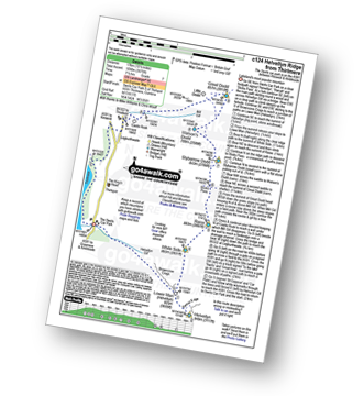
Route Summary:
The Swirls Car Park Thirlmere - Browncove Crags - Lower Man (Helvellyn) - Helvellyn - White Side - Raise (Helvellyn) - Sticks Pass - Stybarrow Dodd - Watson's Dodd - Great Dodd - Legburthwaite - Thirlmere - Thirlspot - The Swirls Car Park Thirlmere.
Walk c138 Brothers Water from Patterdale
Lovely valley stroll
|
Vital Statistics:
| Length: | 6.5 miles (10.5 km) |
| Ascent: | 643ft (196m) |
| Time: | 3 hrs |
| Grade: |  |
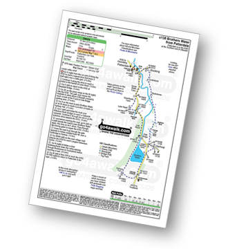
Route Summary:
Patterdale - Noran Bank Farm - Greenbank Farm - Lane Head - Deepdale Bridge - Low Wood - Cow Bridge - Brothers Water - Hartsop Hall - Sykeside - Brothers Water - Hartsop - Eden Beck - Hartsop Fold - Angletarn Beck - Beckstones - Crookabeck - Dubhow - Rooking - Patterdale
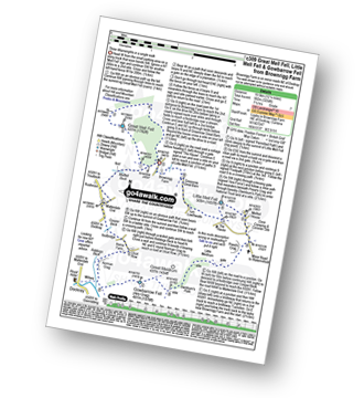
Walk c146 The Dodds from Dockray
Superb views of Ullswater and Thirlmere
|
Vital Statistics:
| Length: | 8.75 miles (14 km) |
| Ascent: | 2,129ft (649m) |
| Time: | 5½ hrs |
| Grade: | |
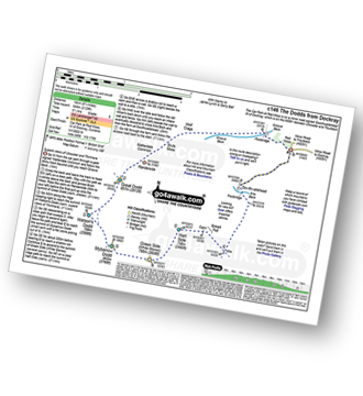
Route Summary:
Red Moss Nr Dockray - Matterdale Common - Wolf Crags - Bruts Moss - Randerside - Great Dodd - Watson's Dodd - Stybarrow Dodd - Green Side (White Stones) - Hart Side - Dowthwaitehead - Red Moss.
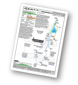
Walk c162 Stony Cove Pike (Caudale Moor), Red Screes and Hart Crag from Brothers Water
Long high level route with one very steep climb
|
Vital Statistics:
| Length: | 13.75 miles (22 km) |
| Ascent: | 5,501ft (1,676m) |
| Time: | 10½ hrs |
| Grade: |  |
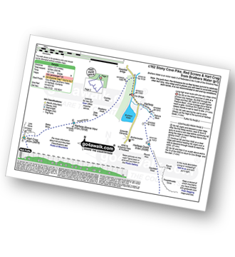
Route Summary:
Cow Bridge Car Park - Brothers Water - Hartsop - Hartsop Dodd - Caudale Moor - Stony Cove Pike (Caudale Moor) - Caudale Head - Pike How - St Raven's Edge - The Kirkstone Pass - Red Screes - Smallthwaite Band - Middle Dodd - Scandale Pass - Little Hart Crag - High Hartsop Dodd - Little Hart Crag - Scandale Head - Dove Crag - Hart Crag - Blake Brow - Hartsop Above How - Hoggill Brow - Gale Crag - Bleaberry Knott - Cockley How - Cow Bridge
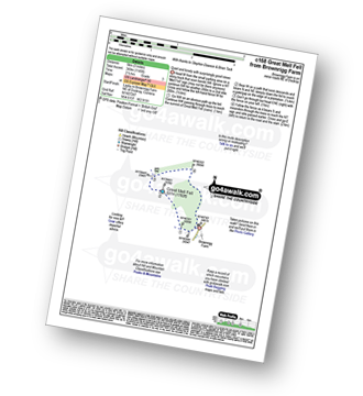
Walk c168 Great Mell Fell from Brownrigg Farm
Quiet and lonely with surprisingly good views
|
Vital Statistics:
| Length: | 3 miles (5 km) |
| Ascent: | 1,145ft (349m) |
| Time: | 2½ hrs |
| Grade: | |
Walk c176 Clough Head and Great Dodd from Dockray
Superb views
|
Vital Statistics:
| Length: | 8.25 miles (13 km) |
| Ascent: | 2,011ft (613m) |
| Time: | 5 hrs |
| Grade: | |
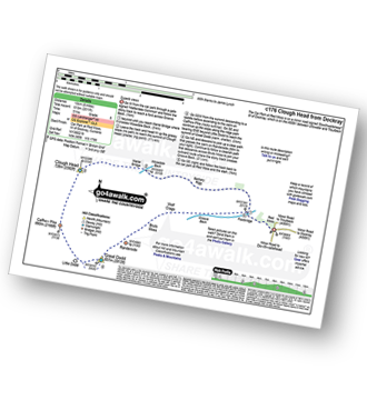
Route Summary:
Red Moss Nr Dockray - Barbary Rigg - Matterdale Common - Mariel Bridge - White Pike (Clough Head) - Clough Head - Calfhow Pike - Little Dodd (St John's Common) - Great Dodd - Randerside - Bruts Moss - Wolf Crags - Red Moss.
Walk c178 Sheffield Pike from Glenridding
Glenridding's much ignored fell
|
Vital Statistics:
| Length: | 6 miles (9.5 km) |
| Ascent: | 1,814ft (553m) |
| Time: | 4 hrs |
| Grade: |  |
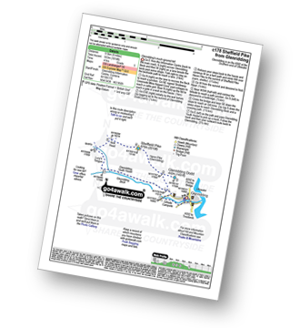
Route Summary:
Glenridding - Glenridding Dodd - Sheffield Pike - Nick Head - Lucy's Tongue - Glenridding Beck - Glenridding
Walk c181 Dollywaggon Pike and Seat Sandal from Patterdale
Great high level route with an easy scramble
|
Vital Statistics:
| Length: | 10 miles (16 km) |
| Ascent: | 3,979ft (1,213m) |
| Time: | 7½ hrs |
| Grade: | |
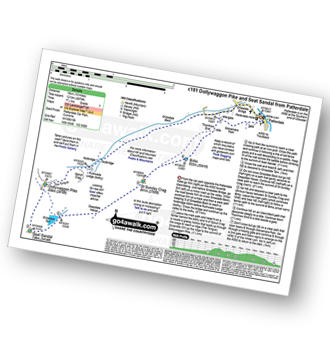
Route Summary:
Patterdale - Grisedale Bridge - Ruthwaite Lodge - The Tongue - Dollywaggon Pike - Seat Sandal - Grisedale Tarn - Deepdale Hause - St Sunday Crag - Birks - Patterdale
Walk c184 Red Screes and High Pike (Scandale) from Ambleside
Quieter alternative to the popular routes from Ambleside
|
Vital Statistics:
| Length: | 9.75 miles (15.5 km) |
| Ascent: | 3,551ft (1,082m) |
| Time: | 7.25hrs |
| Grade: | |
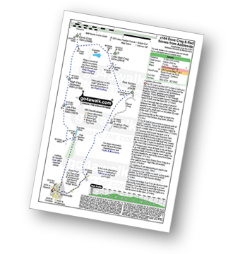
Route Summary:
Ambleside - Snarker Pike - Red Screes - Scandale Pass - Little Hart Crag - Dove Crag - High Pike (Scandale) - Low Pike (Scandale) - High Sweden Bridge - Ambleside
Walk c192 Helvellyn Ridge from Glenridding
An exhilarating high ridge walk
|
Vital Statistics:
| Length: | 13 miles (21 km) |
| Ascent: | 4,359ft (1,329m) |
| Time: | 9.25hrs |
| Grade: |  |
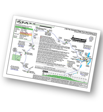
Route Summary:
Glenridding - Glenridding Dodd - Sheffield Pike - Green Side - Stybarrow Dodd - Sticks Pass - Raise (Helvellyn) - White Side - Lower Man (Helvellyn) - Helvellyn - Nethermost Pike - High Crag (Helvellyn) - Dollywaggon Pike - Grisdale Tarn - Grisedale Beck - Brownend Plantation - Lanty's Tarn - Keldas - Glenridding
Walk c193 Dowthwaitehead from Aira Force
An impressive waterfall and a taste of the fells
|
Vital Statistics:
| Length: | 7.25 miles (11.5 km) |
| Ascent: | 1,752ft (534m) |
| Time: | 4½ hrs |
| Grade: | |
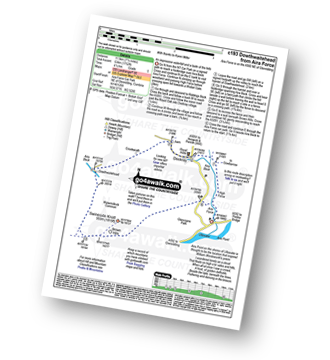
Route Summary:
Aira Force National Trust Car Park (nr Glenridding) - Aira Force - Riddings Beck - Waterfalls - High Force - Dockray - Aira Beck - Matterdale Common - Dowthwaitehead - Brown Hills - Swineside Knott - Glencoyne Park - Aira Force Car Park.
Walk c198 The Southern Shore of Ullswater from Glenridding
Popular lakeside walk
|
Vital Statistics:
| Length: | 7 miles (11 km) |
| Ascent: | 1,299ft (396m) |
| Time: | 3.75hrs |
| Grade: |  |
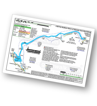
Route Summary:
Glenridding - Glenridding Pier - Ullswater Steamer - Howtown Pier - Geordie's Crag - Halinhag Wood - Sandwick - Long Crag (Ullswater) - Silver Point - Ullswater - Blowick - Rooking - Side Farm - Patterdale
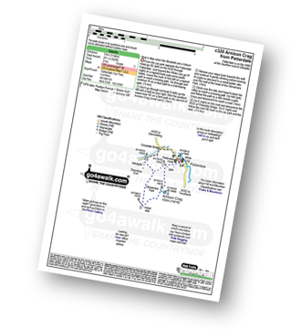
Walk c211 Arnison Crag and Birks from Patterdale
Best in May when the Bluebells are in bloom
|
Vital Statistics:
| Length: | 3.75 miles (6 km) |
| Ascent: | 1,571ft (479m) |
| Time: | 3 hrs |
| Grade: | |
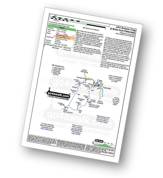
Route Summary:
Patterdale - Arnison Crag - Glenamara Park - Birks - Thornhow End - Grisedale Bridge - Patterdale
Walk c213 Helvellyn from Glenridding
Lakeland's 3rd highest via the infamous Striding & Swirral Edges - not for the faint hearted
|
Vital Statistics:
| Length: | 8.5 miles (13.5 km) |
| Ascent: | 3,278ft (999m) |
| Time: | 6½ hrs |
| Grade: | |
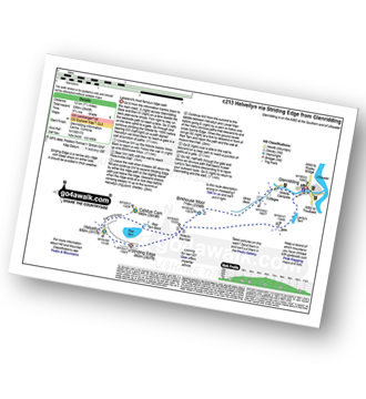
Route Summary:
Glenridding - Birkhouse Moor - Hole-in-the-Wall - Red Tarn (Helvellyn) - Bleaberry Crag - Low Spying How - High Spying How - Striding Edge (High Spying How) - Helvellyn - Swirral Edge - Catstye Cam - Hole-in-the-Wall - Brownend Plantation - Grisedale Beck - Lanty's Tarn - Keldas - Glenridding
Walk c216 Stone Arthur, Great Rigg and Heron Pike from Grasmere
Fabulous views of Grasmere - the descent off Heron Pike is down steep grass
|
Vital Statistics:
| Length: | 7 miles (11 km) |
| Ascent: | 2,661ft (811m) |
| Time: | 5.25hrs |
| Grade: | |
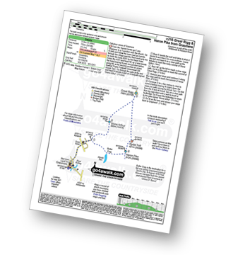
Route Summary:
Grasmere - River Rothay - Grasmere (A591) - Stone Arthur - Great Rigg - Rydal Fell (Heron Pike North Top) - Heron Pike - Butter Crag - Alcock Tarn - Brackenfell - Dove Cottage - Grasmere (A591) - Grasmere
Walk c220 Helvellyn via Striding Edge (High Spying How) from Glenridding
Lakeland's most climbed mountain via the infamous Striding Edge - not for the faint hearted
|
Vital Statistics:
| Length: | 10 miles (16 km) |
| Ascent: | 3,382ft (1,031m) |
| Time: | 7 hrs |
| Grade: | |
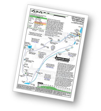
Route Summary:
Glenridding - Birkhouse Moor - Hole-in-the-Wall - Red Tarn (Helvellyn) - Bleaberry Crag - Low Spying How - High Spying How - Striding Edge (High Spying How) - Helvellyn - Nethermost Pike - High Crag (Helvellyn) - Dollywaggon Pike - Grisdale Tarn - Ruthwaite Lodge - Grisedale Beck - Brownend Plantation - Lanty's Tarn - Keldas - Glenridding
Walk c224 Helvellyn via Swirral Edge and Raise from Glenridding
Lakeland's most popular via the easier Swirral Edge
|
Vital Statistics:
| Length: | 10.75 miles (17 km) |
| Ascent: | 3,449ft (1,051m) |
| Time: | 7.25hrs |
| Grade: | |
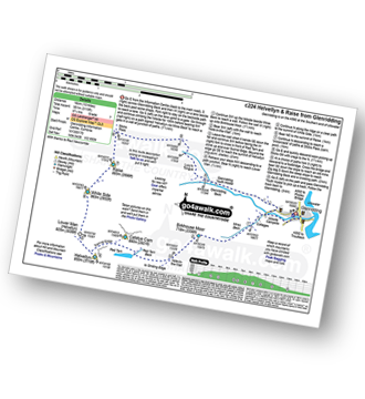
Route Summary:
Glenridding - Birkhouse Moor - Hole-in-the-Wall - Red Tarn (Helvellyn) - Catstye Cam - Swirral Edge - Helvellyn - Lower Man (Helvellyn) - White Side - Raise (Helvellyn) - Sticks Pass - Lucy's Tongue - Glenridding Beck - Glenridding
Walk c230 The Scandale Beck Horizon from Ambleside
Fabulous high level route
|
Vital Statistics:
| Length: | 12.5 miles (20 km) |
| Ascent: | 3,411ft (1,040m) |
| Time: | 8 hrs |
| Grade: | |
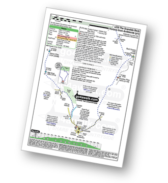
Route Summary:
Ambleside - Rydal - Nab Scar - Heron Pike - Rydal Fell (Heron Pike North Top) - Great Rigg - Fairfield - Rydal Head - Hart Crag - Dove Crag - Little Hart Crag - Scandale Pass - Red Screes - Snarker Pike - Ambleside
Walk c235 The Deepdale Horseshoe from Patterdale
Quieter alternative to crowded Helvellyn
|
Vital Statistics:
| Length: | 9.75 miles (15.5 km) |
| Ascent: | 3,516ft (1,072m) |
| Time: | 7 hrs |
| Grade: | |
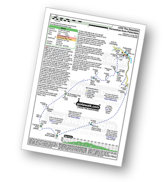
Route Summary:
Patterdale - Arnison Crag - Birks - St Sunday Crag - Deepdale Hause - Cofa Pike - Fairfield - Rydal Head - Hart Crag - Blake Brow - Hartsop Above How - Hoggill Brow - Gale Crag - Bleaberry Knott - Cockley How - Bridgend - Patterdale
Walk c237 Grisedale Beck from Patterdale
Delightful valley walk
|
Vital Statistics:
| Length: | 7 miles (11 km) |
| Ascent: | 1,273ft (388m) |
| Time: | 3.75hrs |
| Grade: | |
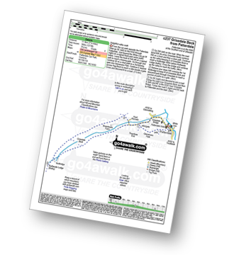
Route Summary:
Patterdale - Glenamara Park - Braesteads Farm - Elmhow Farm - Grisedale Bridge - Grisedale Beck - Ruthwaite Lodge (Bothy) - Grisedale Beck - Nethermostcove Beck - Grisedale Bridge - Patterdale
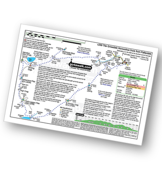
Walk c239 The Deepdale Round from nr Dockray
Superb views of Ullswater and Thirlmere
|
Vital Statistics:
| Length: | 11.25 miles (18 km) |
| Ascent: | 2,680ft (817m) |
| Time: | 6.75hrs |
| Grade: | |
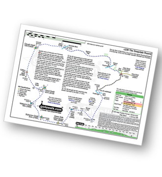
Route Summary:
Red Moss Nr Dockray - Barbary Rigg - Matterdale Common - Mariel Bridge - White Pike (Clough Head) - Clough Head - Calfhow Pike - Little Dodd (St John's Common) - Great Dodd - Watson's Dodd - Stybarrow Dodd - Green Side (White Stones) - Hart Side - Dowthwaitehead - Red Moss.
Walk c247 The Fairfield Horseshoe from Ambleside
A classic lakeland horseshoe walk
|
Vital Statistics:
| Length: | 11 miles (17.5 km) |
| Ascent: | 3,633ft (1,107m) |
| Time: | 7.75hrs |
| Grade: | |
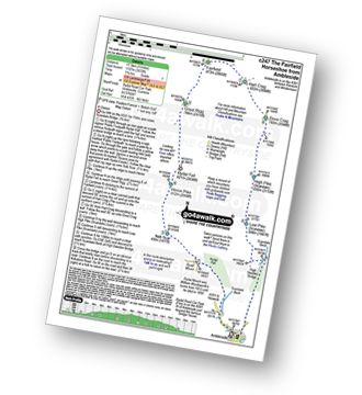
Route Summary:
Ambleside - Rydal - Nab Scar - Heron Pike - Rydal Fell (Heron Pike North Top) - Great Rigg - Fairfield - Rydal Head - Hart Crag - Dove Crag - High Pike (Scandale) - Low Pike (Scandale) - High Sweden Bridge - High Sweden Coppice - Ambleside
Walk c259 A Circuit of Thirlmere
Lakeside walk with one short steep climb
|
Vital Statistics:
| Length: | 10 miles (16 km) |
| Ascent: | 492ft (150m) |
| Time: | 4 hrs |
| Grade: | |
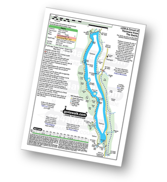
Route Summary:
The Swirls Car Park - Thirlmere - Dalehead Hall - Thirlspot - Valve Houses - Beech Grove - Armboth - Hause Point - Dobgill Bridge - Wythburn - Stockhow Bridge - Wyth Burn - Helvellyn Screes - Highpark Wood - The Swirls Car Park - Thirlmere
Walk c264 The Grisedale Round from Patterdale
Superb high level ridge walk
|
Vital Statistics:
| Length: | 13.25 miles (21 km) |
| Ascent: | 5,189ft (1,581m) |
| Time: | 10 hrs |
| Grade: | |
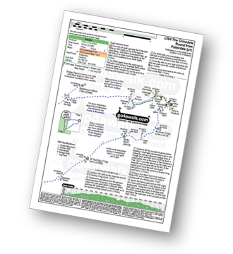
Route Summary:
Patterdale - Grisedale Bridge - Grisedale Beck - Brownend Plantation - Hole-in-the-Wall - Birkhouse Moor - Hole-in-the-Wall - Red Tarn (Helvellyn) - Bleaberry Crag - Low Spying How - High Spying How - Striding Edge (High Spying How) - Helvellyn - Nethermost Pike - High Crag (Helvellyn) - Dollywaggon Pike - Seat Sandal - Grisedale Tarn - St Sunday Crag - Birks - Arnison Crag - Patterdale
Walk c266 Seat Sandal and Fairfield from Grasmere
Fabulous views - classic Lakeland
|
Vital Statistics:
| Length: | 7.5 miles (12 km) |
| Ascent: | 3,116ft (950m) |
| Time: | 6 hrs |
| Grade: | |
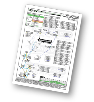
Route Summary:
Grasmere - Wainwright's Coast to Coast Walk - Mill Bridge - Little Tongue - Seat Sandal - Grisedale Tarn - Fairfield - Rydal Head - Great Rigg - Stone Arthur - Grasmere
Walk c269 The Grisedale Horseshoe from Patterdale
Lakeland's most climbed mountain - not for the faint hearted
|
Vital Statistics:
| Length: | 11.5 miles (18.5 km) |
| Ascent: | 4,582ft (1,396m) |
| Time: | 8.75hrs |
| Grade: | |
Route Summary:
Patterdale - Grisedale Bridge - Grisedale Beck - Brownends Plantation - Hole-in-the-Wall - Birkhouse Moor - Hole-in-the-Wall - Red Tarn (Helvellyn) - Bleaberry Crag - Low Spying How - High Spying How - Striding Edge (High Spying How) - Helvellyn - Nethermost Pike - High Crag (Helvellyn) - Dollywaggon Pike - Grisedale Tarn - Deepdale Hause - St Sunday Crag - Birks - Patterdale
Walk c286 The Glenridding Skyline from Glenridding
Superb high level walk
|
Vital Statistics:
| Length: | 11.5 miles (18.5 km) |
| Ascent: | 4,418ft (1,346m) |
| Time: | 8½ hrs |
| Grade: | |
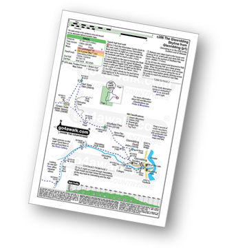
Route Summary:
Glenridding - Glenridding Dodd - Sheffield Pike - Nick Head - Glencoyne Head - Hart Side - Green Side (White Stones) - Stybarrow Dodd - Sticks Pass - Raise (Helvellyn) - White Side - Lower Man (Helvellyn) - Helvellyn - Swirral Edge - Catstye Cam - Red Tarn Beck - Glenridding Beck - Glenridding Youth Hostel - Glenridding
Walk c305 Red Screes and Hart Crag from Brothers Water
Superb views of Brothers Water and Patterdale
|
Vital Statistics:
| Length: | 9.75 miles (15.5 km) |
| Ascent: | 3,699ft (1,127m) |
| Time: | 7.25hrs |
| Grade: | |
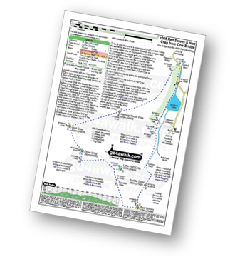
Route Summary:
Cow Bridge Car Park - Brothers Water - Hartsop Hall - Kirkstone Beck - Caiston Beck - Middle Dodd - Red Screes - Scandale Pass - Little Hart Crag - Dove Crag - Hart Crag - Blake Brow - Hartsop Above How - Hoggill Brow - Gale Crag - Bleaberry Knott - Cockley How - Cow Bridge
Walk c309 Great Mell Fell, Little Mell Fell and Gowbarrow Fell
Three remote Wainwrights in a single walk
|
Vital Statistics:
| Length: | 12.25 miles (19.5 km) |
| Ascent: | 3,254ft (992m) |
| Time: | 7½ hrs |
| Grade: | |
Route Summary:
Brownrigg Farm - Great Mell Fell - Greenrow Great Barn - Lowthwaite - Little Mell Fell - The Hause - Underwood - Cove Park Campsite - Watermillock - Priest's Crag - Great Meldrum - Gowbarrow Fell (Airy Crag) - Norman Crag - Ulcat Row - Matterdale End - Brownrigg Farm
Walk c312 Red Screes from Brothers Water
Fine views of Brothers Water
|
Vital Statistics:
| Length: | 7 miles (11 km) |
| Ascent: | 2,373ft (723m) |
| Time: | 5 hrs |
| Grade: | |
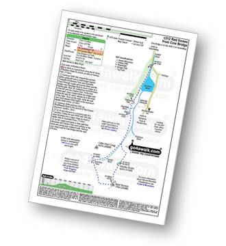
Route Summary:
Cow Bridge - Brothers Water - Hartsop Hall - Kirkstone Beck - Caiston Beck - Middle Dodd - Red Screes - Scandale Pass - Caiston Beck - Brothers Water.
Walk c320 Arnison Crag from Patterdale
Best in May when the Bluebells are in bloom
|
Vital Statistics:
| Length: | 3 miles (5 km) |
| Ascent: | 922ft (281m) |
| Time: | 2 hrs |
| Grade: | |
Walk c333 The Dovedale Round
Fine views of Dovedale and Brothers Water
|
Vital Statistics:
| Length: | 7.75 miles (12.5 km) |
| Ascent: | 2,800ft (853m) |
| Time: | 5.75hrs |
| Grade: | |
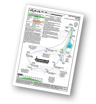
Route Summary:
Cow Bridge Car Park - Brothers Water - Hartsop Hall - Kirkstone Beck - High Hartsop Dodd - Little Hart Crag - Dove Crag - Hart Crag - Blake Brow - Hartsop Above How - Hoggill Brow - Gale Crag - Bleaberry Knott - Cockley How - Cow Bridge
Walk c351 Red Screes and Little Hart Crag from Brothers Water
Superb views of Brothers Water
|
Vital Statistics:
| Length: | 7 miles (11 km) |
| Ascent: | 2,737ft (834m) |
| Time: | 5.25hrs |
| Grade: | |
Route Summary:
Cow Bridge - Brothers Water - Hartsop Hall - Kirkstone Beck - Caiston Beck - Middle Dodd - Red Screes - Scandale Pass - Little Hart Crag - High Hartsop Dodd - Caiston Beck - Cow Bridge - Brothers Water.
Walk c352 Gowbarrow Fell (Airy Crag) from Aira Force
An impressive waterfall and a taste of the fells
|
Vital Statistics:
| Length: | 4.5 miles (7 km) |
| Ascent: | 1,204ft (367m) |
| Time: | 3 hrs |
| Grade: | |
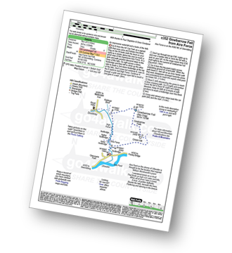
Route Summary:
Aira Force National Trust Car Park (nr Glenridding) - Aira Force - Riddings Beck - Waterfalls - High Force - Gowbarrow Fell (Airy Crag) - Gowbarrow Park - Green Hill (Gowbarrow Fell) - Aira Force Car Park.
Walk c358 Seat Sandal, Fairfield and Heron Pike from Grasmere
Fabulous views - classic Lakeland
|
Vital Statistics:
| Length: | 9.5 miles (15 km) |
| Ascent: | 3,682ft (1,122m) |
| Time: | 7.25hrs |
| Grade: | |
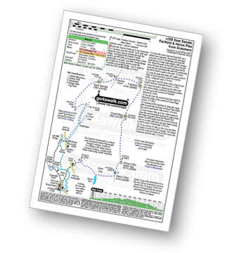
Route Summary:
Grasmere - Mill Bridge - Little Tongue - Seat Sandal - Grisedale Tarn - Fairfield - Rydal Head - Great Rigg - Rydal Fell (Heron Pike North Top) - Heron Pike - Alcock Tarn - Grasmere
Walk c380 Little Mell Fell from Cove Campsite
Good views of Ullswater
|
Vital Statistics:
| Length: | 1.5 miles (2.5 km) |
| Ascent: | 705ft (215m) |
| Time: | 1½ hrs |
| Grade: |  |
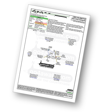
Route Summary:
Cove Park Campsite - Watermillock - Mellfell House - Little Mell Fell - The Hause - Cove Campsite - Watermillock.
Walk c389 Great Rigg, Fairfield and Hart Crag from Ambleside
A variation on a classic route
|
Vital Statistics:
| Length: | 12.25 miles (19.5 km) |
| Ascent: | 3,984ft (1,214m) |
| Time: | 8½ hrs |
| Grade: | |
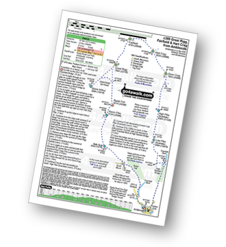
Route Summary:
Ambleside - Rydal - Nab Scar - Heron Pike - Rydal Fell (Heron Pike North Top) - Greenhead Gill Head - Stone Arthur - Great Rigg - Fairfield - Rydal Head - Hart Crag - Dove Crag - High Pike (Scandale) - Low Pike (Scandale) - High Sweden Bridge - High Sweden Coppice - Ambleside
Walk c394 Helvellyn, Catstye Cam and Sheffield Pike from Glenridding
Superb high level walk
|
Vital Statistics:
| Length: | 10 miles (16 km) |
| Ascent: | 4,020ft (1,225m) |
| Time: | 8 hrs |
| Grade: | |
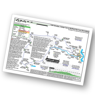
Route Summary:
Glenridding - Glenridding Dodd - Sheffield Pike - Nick Head - Sticks Pass - Raise (Helvellyn) - White Side - Lower Man (Helvellyn) - Helvellyn - Swirral Edge - Catstye Cam - Glenridding Beck - Glenridding Youth Hostel - Glenridding
Walk c412 Wansfell Pike and Baystones (Wansfell) from Ambleside
The easiest way up Ambleside's local Wainwright
|
Vital Statistics:
| Length: | 5 miles (8 km) |
| Ascent: | 1,769ft (539m) |
| Time: | 3.75hrs |
| Grade: | |
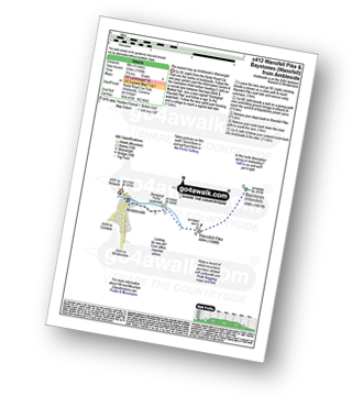
Route Summary:
Ambleside - Stockghyll Force - Wansfell Pike - Baystones (Wansfell) - Wansfell Pike - Stockghyll Force - Ambleside
Walk c427 Helvellyn via Striding Edge (High Spying How) from Patterdale
Lakeland's 3rd highest via the infamous Striding Edge
|
Vital Statistics:
| Length: | 8 miles (12.5 km) |
| Ascent: | 2,990ft (911m) |
| Time: | 6 hrs |
| Grade: | |
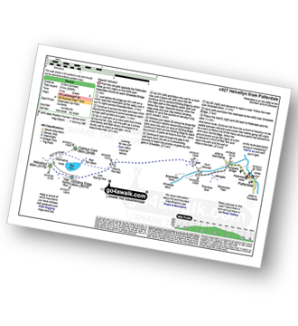
Route Summary:
Patterdale - Patterdale Church - Grisedale Bridge - Grisedale Beck - Brownend Plantation - Lanty's Tarn - Hole-in-the-Wall - Red Tarn (Helvellyn) - Bleaberry Crag - Low Spying How - High Spying How - Striding Edge (High Spying How) - Helvellyn - Swirral Edge (optional) - Hole-in-the-Wall - Grisedale Beck - Patterdale
Walk c429 Dunmallard Hill (Dunmallet) from Pooley Bridge
Quick leg stretcher before breakfast
|
Vital Statistics:
| Length: | 1.5 miles (2.5 km) |
| Ascent: | 351ft (107m) |
| Time: | 1 hrs |
| Grade: |  |
Route Summary:
Pooley Bridge - Dunmallet Woods - Dunmallard Hill (Dunmallet) - River Eamont - Pooley Bridge
Walk c432 Helvellyn from Thirlmere
The 'easiest' way up Lakeland's most climbed mountain
|
Vital Statistics:
| Length: | 5 miles (8 km) |
| Ascent: | 2,649ft (807m) |
| Time: | 4½ hrs |
| Grade: | |
Route Summary:
The Swirls - Helvellyn Gill - Browncove Crags - Lower Man (Helvellyn) - Helvellyn - Lower Man (Helvellyn) - Browncove Crags - Helvellyn Gill - The Swirls
Walk c433 The St John's in the Vale Skyline from Legburthwaite
A fine walk with fine views
|
Vital Statistics:
| Length: | 11.25 miles (18 km) |
| Ascent: | 3,965ft (1,208m) |
| Time: | 8.25hrs |
| Grade: | |
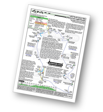
Route Summary:
Legburthwaite Car Park - A591 - Long Band - Cowrake Head - Moss Crag - High Rigg - Carlisle Diocese Youth Centre - St John's In The Vale Church - B5322 - Wanthwaite Bank - Threlkeld Knotts - Buck Castles - Clough Head - Calfhow Pike - Great Dodd - Watson's Dodd - Stybarrow Dodd - Sticks Pass - Legburthwaite Car Park
Walk c455 Wansfell Pike from Ambleside
The easiest way up Ambleside's nearest fell
|
Vital Statistics:
| Length: | 3.25 miles (5 km) |
| Ascent: | 1,428ft (435m) |
| Time: | 2½ hrs |
| Grade: | |
See this list of walks, routes & maps in:
Grade Order | Length Order | Time Order | Walk Number or Start Location Order
NB. To reverse (toggle) this order, click Grade Order again