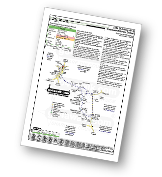
29 easy-to-follow circular walk route maps of all grades in The Northern Fells area of The Lake District
Twenty-nine easy-to-follow, hand-crafted walks including routes from Fell Side, Grainsgill Bridge, High Side, Keswick, Mosedale, Mungrisdale, Over Water, Scales & Threlkeld that climb the Skiddaw (the highest point), Blencathra, Carrock Fell, Bannerdale Crags, Carl Side, Binsey, Bowscale Fell & Ullock Pike amongst others. More details about each walk can be found below the map.
The Northern Fells area of The Lake District National Park is enclosed by:
- Keswick and Threlkeld to the South
- The River Derwent and Bassenthwaite Lake to the South West
- The boundary of The Lake District National Park to the North and East
Tap/mouse over a coloured circle (1-3 easy walks, 4-6 moderate walks, 7-9 hard walks) and click to select.
You can use these checkboxes to show only the grades of walk you are interested in:-
Scroll down the list of walks below & click on each walk title (in blue) to locate it on the map above.
See this list of walks, routes & maps in:
Grade Order | Length Order | Time Order | Walk Number or Start Location Order
NB. To reverse (toggle) this order, click Grade Order again
   |
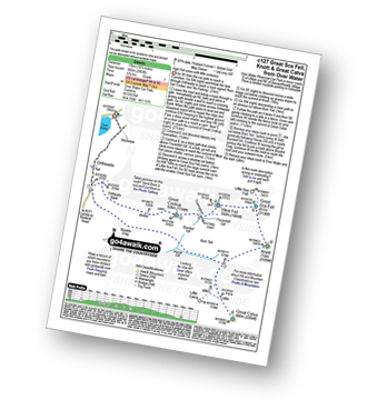
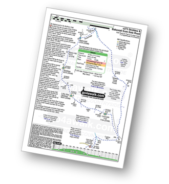
Vital Statistics:
| Length: | 9.5 miles (15 km) |
| Ascent: | 2,140ft (652m) |
| Time: | 5½ hrs |
| Grade: |  |
Route Summary:
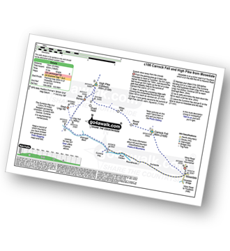
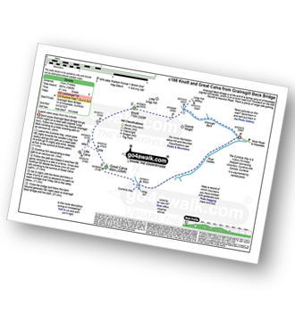
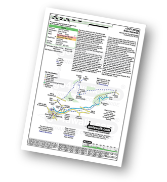
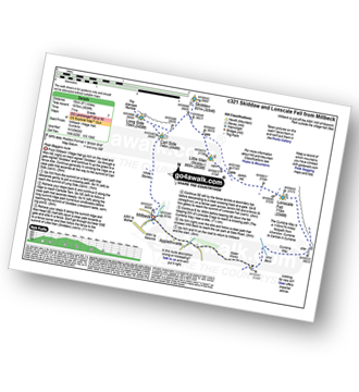
Stone Ends Farm - Apronful of Stones - Rake Trod - Further Gill Sike - Scurth - The Trough - Carrock Fell - Round Knott (Caldbeck) - Miton Hill (Caldbeck) - Red Gate (Track) - High Pike (Caldbeck) - Hare Stones - Great Lingy Hill - Miller Moss - Lingy Hut - Grainsgill Beck - The Cumbria Way - River Caldew - Swineside - Mosedale (Mungrisdale) - Stone Ends Farm
|
Vital Statistics:
| Length: | 6.25 miles (10 km) |
| Ascent: | 2,565ft (782m) |
| Time: | 4.75hrs |
| Grade: | |
Route Summary:
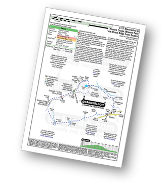
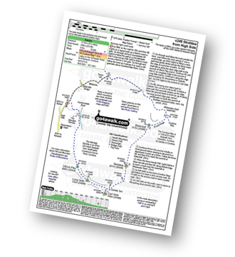
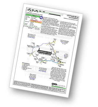
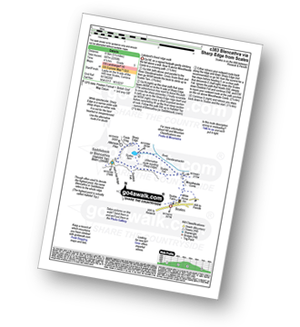
Scales - Mousthwaite Comb - Scales Fell - Brunt Knott - Scales Beck - Scales Tarn - Sharp Edge - Atkinson Pike - Blencathra or Saddleback (Hallsfell Top) - Gategill Fell Top - Knowe Crag (Blease Fell) - Scales
|
Vital Statistics:
| Length: | 7.75 miles (12.5 km) |
| Ascent: | 2,453ft (748m) |
| Time: | 5.25hrs |
| Grade: | |
Route Summary:
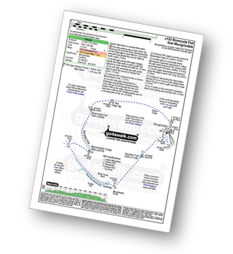
Mungrisdale - Souther Fell - River Glendermackin - Bannerdale Crags - Bowscale Fell - Mungrisdale
|
Vital Statistics:
| Length: | 9.5 miles (15 km) |
| Ascent: | 1,250ft (381m) |
| Time: | 4.75hrs |
| Grade: |  |
Route Summary:
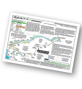
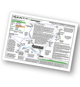
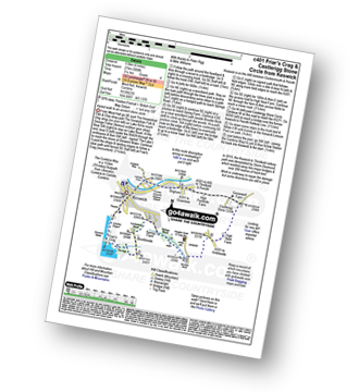
Keswick - Friar's Crag - Borrowdale Road - Spring Farm - Brockle Beck - Castlerigg - High Nest Farm - Castlerigg Stone Circle - Naddle Bridge - Threlkeld - River Greta - Keswick
|
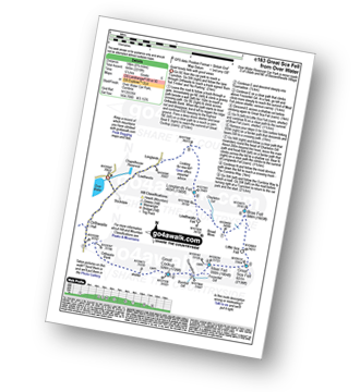
Vital Statistics:
| Length: | 10.5 miles (17 km) |
| Ascent: | 2,903ft (885m) |
| Time: | 6.75hrs |
| Grade: |  |
Route Summary:
Over Water Reservoir - Orthwaite - Orthwaite Bank - Uldale Fells - Great Cockup - Frozenfell Gill - Trusmadoor - Meal Fell - Little Sca Fell - Great Sca Fell - Knott (Uldale Fells) - Little Calva - Great Calva - Hause Gill - Burn Tod - Burntod Gill - Brockle Crags - Orthwaite - Over Water
|
Vital Statistics:
| Length: | 9 miles (14.5 km) |
| Ascent: | 2,624ft (800m) |
| Time: | 6 hrs |
| Grade: | |
Route Summary:
Over Water - Orthwaite - Orthwaite Bank - Uldale Fells - Great Cockup - Trusmadoor - Meal Fell - Great Sca Fell - Little Sca Fell - Brae Fell - Broad Moss - Lowthwaite Fell - Longlands Fell - The Cumbria Way - Longlands - Lowthwaite - Over Water
|
Vital Statistics:
| Length: | 3.75 miles (6 km) |
| Ascent: | 2,398ft (731m) |
| Time: | 3.75hrs |
| Grade: | |
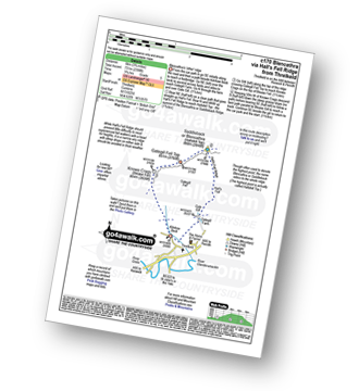
Route Summary:
Threlkeld - Gategill Farm - Hall's Fell - Hall's Fell Ridge - Blencathra or Saddleback (Hallsfell Top) - Gategill Fell Top - Knowe Crags (Blease Fell) - Threlkeld
|
Vital Statistics:
| Length: | 10.25 miles (16.5 km) |
| Ascent: | 2,850ft (869m) |
| Time: | 6½ hrs |
| Grade: | |
Route Summary:
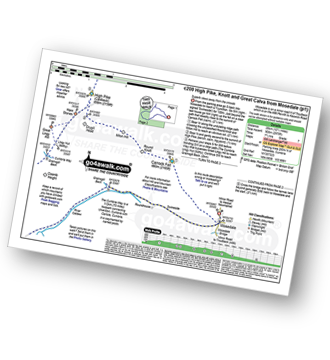
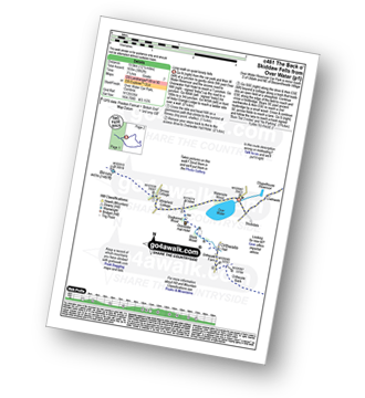
Keswick - Gale Road (Underscar) Nr Keswick - Lonscale Fell - Jenkin Hill - Little Man (Skiddaw) - Skiddaw - Sale How (Skiddaw) - Skiddaw House - Gale Road (Underscar) Nr Keswick.
|
Vital Statistics:
| Length: | 7 miles (11 km) |
| Ascent: | 1,860ft (567m) |
| Time: | 4½ hrs |
| Grade: | |
Route Summary:
Grainsgill Bridge - Swineside - Grainsgill Beck - Knott (Uldale Fells) - Little Calva - Great Calva - The Cumbria Way - Wiley Beck - River Caldew - Burdell - Gill - Wet Swine Gill - Grainsgill Beck - Swineside.
|
Vital Statistics:
| Length: | 9.5 miles (15 km) |
| Ascent: | 3,070ft (936m) |
| Time: | 6½ hrs |
| Grade: | |
Route Summary:
Mungrisdale - Souther Fell - River Glendermackin - Brunt Knott - Scales Beck - Scales Tarn - Sharp Edge - Atkinson Pike - Blencathra or Saddleback (Hallsfell Top) - Foule Crag - Bannerdale Crags - Bowscale Fell - Tarn Crags Top - Raven Crags - Mungrisdale
|
Vital Statistics:
| Length: | 14 miles (22.5 km) |
| Ascent: | 2,978ft (908m) |
| Time: | 8.25hrs |
| Grade: |  |
Route Summary:
Stone Ends Farm - Apronful of Stones - Rake Trod - Further Gill Sike - Scurth - The Trough - Carrock Fell - Round Knott (Caldbeck) - Miton Hill (Caldbeck) - Red Gate (Track) - High Pike (Caldbeck) - Hare Stones - Great Lingy Hill - Miller Moss - Lingy Hut - Grainsgill Beck - Knott (Uldale Fells) - Litle Calva - Great Calva - The Cumbria Way - Wiley Beck - River Caldew - Burdell - Gill - Wet Swine Gill - Grainsgill Beck - Swineside - Mosedale (Mungrisdale) - Stone Ends Farm
|
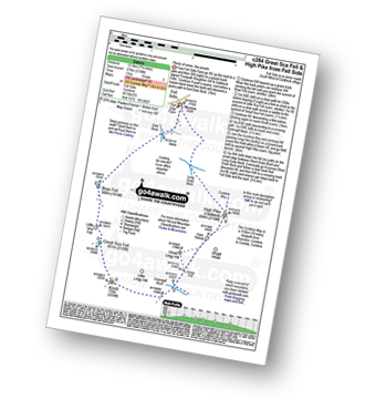
Vital Statistics:
| Length: | 8.25 miles (13 km) |
| Ascent: | 3,306ft (1,008m) |
| Time: | 6.25hrs |
| Grade: | |
Route Summary:
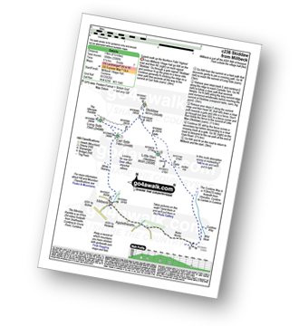
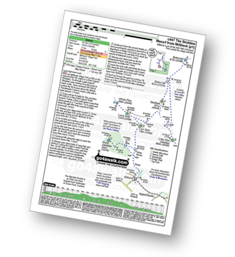
Keswick - Millbeck - The Allerdale Ramble - Doups - White Stones - Carl Side - Longside Edge - Long Side - Skiddaw - Little Man (Skiddaw) - The Cumbria Way - Applethwaite - The Allerdale Ramble - Millbeck - Nr Keswick.
|
Vital Statistics:
| Length: | 6.25 miles (10 km) |
| Ascent: | 941ft (287m) |
| Time: | 3 hrs |
| Grade: |  |
|
Vital Statistics:
| Length: | 11 miles (17.5 km) |
| Ascent: | 3,264ft (995m) |
| Time: | 7.25hrs |
| Grade: | |
Route Summary:
Mungrisdale - Souther Fell - River Glendermackin - Brunt Knott - Scales Beck - Scales Tarn - Sharp Edge - Atkinson Pike - Blencathra or Saddleback (Hallsfell Top) - Mungrisdale Common - Bannerdale Crags - Bowscale Fell - Tarn Crags Top - Raven Crags - Mungrisdale
|
Vital Statistics:
| Length: | 8.25 miles (13 km) |
| Ascent: | 2,919ft (890m) |
| Time: | 6 hrs |
| Grade: | |
Route Summary:
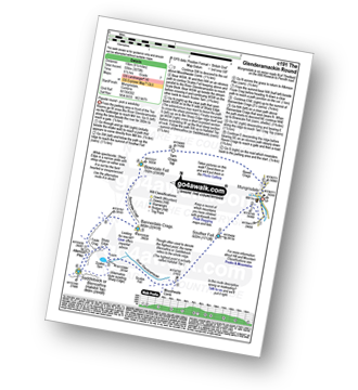
High Side - The Allerdale Ramble - Ling How - The Edge - Ullock Pike - Longside Edge - Long Side - Carl Side - Skiddaw - Bakestall - Birkett Edge - Whitewater Dash - Back O' Skiddaw - Melbecks - High Side
|
Vital Statistics:
| Length: | 4.5 miles (7 km) |
| Ascent: | 361ft (110m) |
| Time: | 2 hrs |
| Grade: |  |
Route Summary:
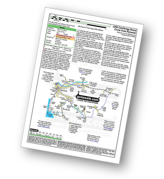
Keswick - Keswick Station - Former Keswick Railway Line - A591 - Chestnut Hill - Castlerigg Stone Circle - High Nest Farm - Castlerigg - Brockle Beck - Springs Farm - Keswick
|
Vital Statistics:
| Length: | 11.5 miles (18.5 km) |
| Ascent: | 3,214ft (980m) |
| Time: | 7½ hrs |
| Grade: | |
Route Summary:
Keswick - Gale Road - Lonscale Fell - Jenkin Hill - Little Man (Skiddaw) - Skiddaw - Bakestall - Birkett Edge - Whitewater Dash - Back O' Skiddaw - The Cumbria Way - Skiddaw House - Gale Road (Underscar) Nr Keswick.
|
Vital Statistics:
| Length: | 7.75 miles (12.5 km) |
| Ascent: | 2,198ft (670m) |
| Time: | 5 hrs |
| Grade: | |
Route Summary:
Fell Side - Dale Beck - Brae Fell - Little Sca Fell - Great Sca Fell - Knott (Uldale Fells) - Grainsgill Beck - The Cumbria Way - Lingy Hut - Miller Moss - Great Lingy Hill - Hare Stones - High Pike (Caldbeck) - Long Grain Beck - Fell Side
|
Vital Statistics:
| Length: | 7.75 miles (12.5 km) |
| Ascent: | 1,292ft (394m) |
| Time: | 4 hrs |
| Grade: | |
Route Summary:
Over Water Reservoir - Binsey Cottage - Binsey - Whittas Park - High House - High Ireby - Ruthwaite - Scawthwaite Mire - Over Water
|
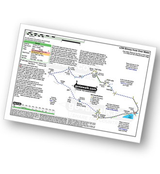
Vital Statistics:
| Length: | 7.25 miles (11.5 km) |
| Ascent: | 3,116ft (950m) |
| Time: | 5.75hrs |
| Grade: | |
Route Summary:
Old Sawmill Tearooms - Longside Wood - The Allerdale Ramble - Ling How - The Edge - Ullock Pike - Longside Edge - Long Side - Carl Side - White Stones - Skill Beck - Dodd (Skiddaw) - Dodd Wood - Old Sawmill Tearooms
|
Vital Statistics:
| Length: | 9.75 miles (15.5 km) |
| Ascent: | 3,529ft (1,076m) |
| Time: | 7 hrs |
| Grade: | |
Route Summary:
Keswick - Millbeck - The Allerdale Ramble - Doups - White Stones - Carl Side - Longside Edge - Long Side - Skiddaw - Little Man (Skiddaw) - Jenkin Hill - Lonscale Fell - Lonscale Crags - The Cumbria Way - Applethwaite - The Allerdale Ramble - Millbeck - Nr Keswick.
|
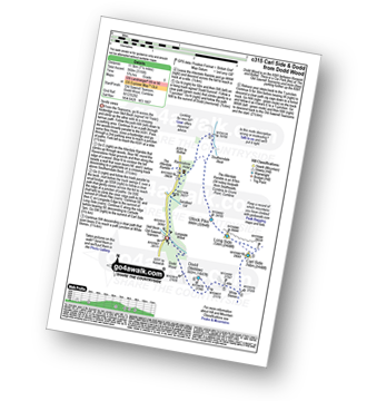
Vital Statistics:
| Length: | 4 miles (6.5 km) |
| Ascent: | 1,430ft (436m) |
| Time: | 2.75hrs |
| Grade: | |
Route Summary:
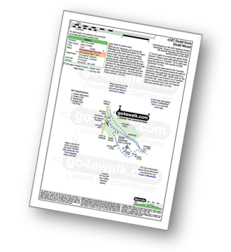
Old Sawmill Tearooms - Longside Wood - Skill Beck - Dodd (Skiddaw) - Dodd Wood - Old Sawmill Tearooms
|
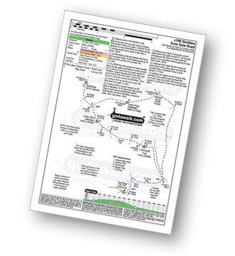
Vital Statistics:
| Length: | 2 miles (3 km) |
| Ascent: | 413ft (126m) |
| Time: | 1 hrs |
| Grade: |  |
Route Summary:
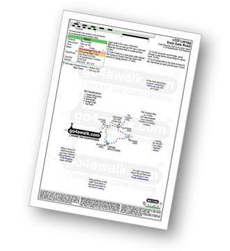
Keswick - Gale Road (Underscar) - The Cumbria Way - Latrigg - Gale Road (Underscar) - Nr Keswick.
|
Vital Statistics:
| Length: | 4.5 miles (7 km) |
| Ascent: | 584ft (178m) |
| Time: | 2.25hrs |
| Grade: |  |
Route Summary:
Caldbeck - Caldbeck Duck Pond - Ratten Row - Grange View - Knocker House - Faulds Brow - Whelpo - Whelpo Bridge - Whelpo Beck - Howk Bobbin Mill - Caldbeck
|
Vital Statistics:
| Length: | 5.25 miles (8.5 km) |
| Ascent: | 2,255ft (687m) |
| Time: | 4½ hrs |
| Grade: | |
Route Summary:
Scales - Mousthwaite Comb - Scales Fell - Brunt Knott - Scales Beck - Scales Tarn - Sharp Edge - Atkinson Pike - Blencathra or Saddleback (Hallsfell Top) - Scales Fell - Mousthwaite Comb - Scales
|
Vital Statistics:
| Length: | 6 miles (9.5 km) |
| Ascent: | 900ft (274m) |
| Time: | 3.24hrs |
| Grade: | |
Route Summary:
Keswick - Friar's Crag - Borrowdale Road - Spring Farm - Brockle Beck - Castlerigg - High Nest Farm - Castlerigg Stone Circle - Brigham - River Greta - Keswick
|
Vital Statistics:
| Length: | 15.25 miles (24.5 km) |
| Ascent: | 5,458ft (1,663m) |
| Time: | 11 hrs |
| Grade: |  |
Route Summary:
Keswick - Millbeck - The Allerdale Ramble - Doups - Dodd (Skiddaw) - White Stones (Skiddaw) - Carl Side - Longside Edge - Long Side - Ullock Pike - Carlside Tarn - Skiddaw - Blake Hill - Bakestall - Little Man (Skiddaw) - Jenkin Hill - Lonscale Fell - Lonscale Crags - The Cumbria Way - Latrigg - Applethwaite - The Allerdale Ramble - Millbeck - Nr Keswick.
|
Vital Statistics:
| Length: | 12.25 miles (19.5 km) |
| Ascent: | 3,062ft (933m) |
| Time: | 7½ hrs |
| Grade: | |
Route Summary:
Over Water Reservoir - Waterside Wood - Whitefield Cottage - Binsey Cottage - Binsey - Dogkennel Wood - Overwater Hall - Black Wood - Orthwaite - Orthwaite Bank - Uldale Fells - Great Cockup - Meal Fell - Great Sca Fell - Little Sca Fell - Brae Fell - Broad Moss - Charleton Gill - Langlands Fell - The Cumbria Way - Lowthwaite - Chapelhouse Reservoir - Over Water
|
Vital Statistics:
| Length: | 5 miles (8 km) |
| Ascent: | 663ft (202m) |
| Time: | 2 hrs |
| Grade: | |
Route Summary:
Bothel - Beck Farm - Borrowscale - The Battery - St. John's Hill (Caermote Hill) - Caermote Hill - Camp Hill - Caermote Roman Fort - Borrowscale - Bothel
See this list of walks, routes & maps in:
Grade Order | Length Order | Time Order | Walk Number or Start Location Order
NB. To reverse (toggle) this order, click Grade Order again


