UK Postcode CA1 - The 30 nearest easy-to-follow, circular walk route maps to you
The thirty nearest easy-to-follow, circular walk route maps to you in UK Postcode CA1 in Walk Grade Order
The UK cities, towns and villages in Cumbria, England that have CA1 in their UK Postcode include:
• Carleton • Carlisle •
Not familiar with the area around CA1?
See these 30 nearest walks to UK Postcode CA1 on a google map
   |
Vital Statistics:
| Length: | 4.5 miles (7 km) |
| Ascent: | 584ft (178m) |
| Time: | 2.25hrs |
| Grade: |  |
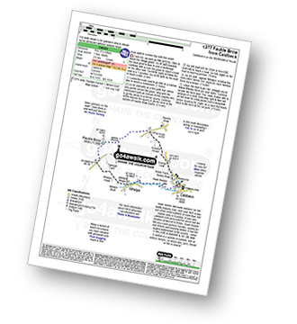
Route Summary:
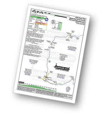
Caldbeck - Caldbeck Duck Pond - Ratten Row - Grange View - Knocker House - Faulds Brow - Whelpo - Whelpo Bridge - Whelpo Beck - Howk Bobbin Mill - Caldbeck
|
Vital Statistics:
| Length: | 11.75 miles (19 km) |
| Ascent: | 1,943ft (592m) |
| Time: | 6.25hrs |
| Grade: |  |
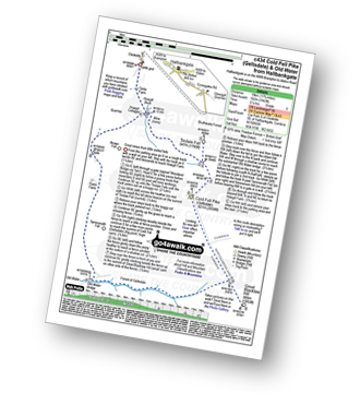
Route Summary:
Clesketts - Tortie Farm - Howgill Cottages - Tindale Fells - Howgill Beck - Tindale Fell - Cold Fell Pike (Geltsdale) - Great Blacklaw Hill - Old Water - Old Water Bridge - Gairs Farm - Howgill Cottages - Clesketts
|
Vital Statistics:
| Length: | 5.75 miles (9 km) |
| Ascent: | 1,480ft (451m) |
| Time: | 3.75hrs |
| Grade: |  |
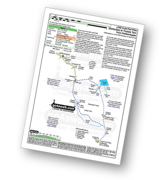
Route Summary:
Clesketts - Tortie Farm - Howgill Cottages - Tindale Fells - Howgill Beck - Cold Fell Pike (Geltsdale) - Tindale Fell - Tindale Tarn - Thron Farm - Clesketts
|
Vital Statistics:
| Length: | 7.75 miles (12.5 km) |
| Ascent: | 2,198ft (670m) |
| Time: | 5 hrs |
| Grade: | |
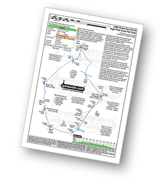
Route Summary:
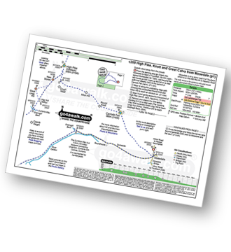
Fell Side - Dale Beck - Brae Fell - Little Sca Fell - Great Sca Fell - Knott (Uldale Fells) - Grainsgill Beck - The Cumbria Way - Lingy Hut - Miller Moss - Great Lingy Hill - Hare Stones - High Pike (Caldbeck) - Long Grain Beck - Fell Side
|
Vital Statistics:
| Length: | 4 miles (6.5 km) |
| Ascent: | 1,293ft (394m) |
| Time: | 2.75hrs |
| Grade: | |
|
Vital Statistics:
| Length: | 10.25 miles (16.5 km) |
| Ascent: | 2,002ft (610m) |
| Time: | 5.75hrs |
| Grade: | |
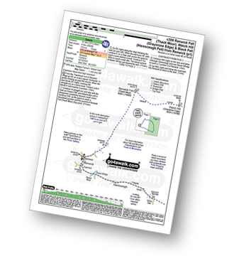
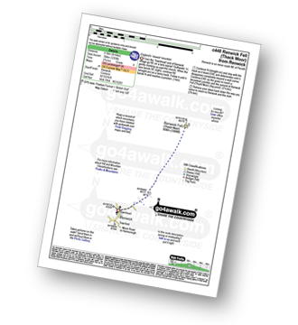
Route Summary:
Renwick - Townend - Renwick Fell (Thack Moor) - Watch Hill (Graystone Edge) - Black Fell (Haresceugh Fell) - Little Daffenside - Hartside Height - Hartside Top Cafe (A686) - Ricker Gill - Seavy Sike - Haresceugh - Raven Bridge - Townfoot - Renwick
|
Vital Statistics:
| Length: | 14 miles (22.5 km) |
| Ascent: | 2,978ft (908m) |
| Time: | 8.25hrs |
| Grade: |  |
Route Summary:
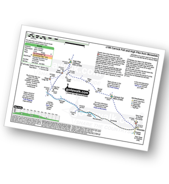
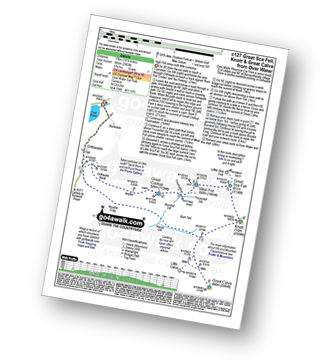
Stone Ends Farm - Apronful of Stones - Rake Trod - Further Gill Sike - Scurth - The Trough - Carrock Fell - Round Knott (Caldbeck) - Miton Hill (Caldbeck) - Red Gate (Track) - High Pike (Caldbeck) - Hare Stones - Great Lingy Hill - Miller Moss - Lingy Hut - Grainsgill Beck - Knott (Uldale Fells) - Litle Calva - Great Calva - The Cumbria Way - Wiley Beck - River Caldew - Burdell - Gill - Wet Swine Gill - Grainsgill Beck - Swineside - Mosedale (Mungrisdale) - Stone Ends Farm
|
Vital Statistics:
| Length: | 9.5 miles (15 km) |
| Ascent: | 2,140ft (652m) |
| Time: | 5½ hrs |
| Grade: | |
Route Summary:
Stone Ends Farm - Apronful of Stones - Rake Trod - Further Gill Sike - Scurth - The Trough - Carrock Fell - Round Knott (Caldbeck) - Miton Hill (Caldbeck) - Red Gate (Track) - High Pike (Caldbeck) - Hare Stones - Great Lingy Hill - Miller Moss - Lingy Hut - Grainsgill Beck - The Cumbria Way - River Caldew - Swineside - Mosedale (Mungrisdale) - Stone Ends Farm
|
Vital Statistics:
| Length: | 7 miles (11 km) |
| Ascent: | 1,860ft (567m) |
| Time: | 4½ hrs |
| Grade: |  |
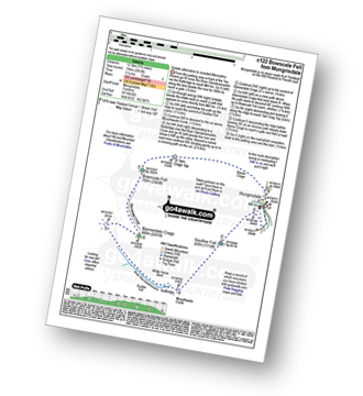
Route Summary:
Grainsgill Bridge - Swineside - Grainsgill Beck - Knott (Uldale Fells) - Little Calva - Great Calva - The Cumbria Way - Wiley Beck - River Caldew - Burdell - Gill - Wet Swine Gill - Grainsgill Beck - Swineside.
|
Vital Statistics:
| Length: | 9.5 miles (15 km) |
| Ascent: | 3,070ft (936m) |
| Time: | 6½ hrs |
| Grade: |  |
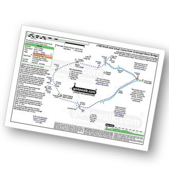
Route Summary:
Mungrisdale - Souther Fell - River Glendermackin - Brunt Knott - Scales Beck - Scales Tarn - Sharp Edge - Atkinson Pike - Blencathra or Saddleback (Hallsfell Top) - Foule Crag - Bannerdale Crags - Bowscale Fell - Tarn Crags Top - Raven Crags - Mungrisdale
|
Vital Statistics:
| Length: | 7.75 miles (12.5 km) |
| Ascent: | 2,453ft (748m) |
| Time: | 5.25hrs |
| Grade: | |
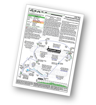
Route Summary:
Mungrisdale - Souther Fell - River Glendermackin - Bannerdale Crags - Bowscale Fell - Mungrisdale
|
Vital Statistics:
| Length: | 11 miles (17.5 km) |
| Ascent: | 3,264ft (995m) |
| Time: | 7.25hrs |
| Grade: | |
Route Summary:
Mungrisdale - Souther Fell - River Glendermackin - Brunt Knott - Scales Beck - Scales Tarn - Sharp Edge - Atkinson Pike - Blencathra or Saddleback (Hallsfell Top) - Mungrisdale Common - Bannerdale Crags - Bowscale Fell - Tarn Crags Top - Raven Crags - Mungrisdale
|
Vital Statistics:
| Length: | 10.5 miles (17 km) |
| Ascent: | 2,903ft (885m) |
| Time: | 6.75hrs |
| Grade: | |
Route Summary:
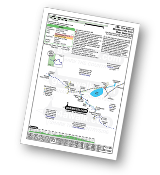
Over Water Reservoir - Orthwaite - Orthwaite Bank - Uldale Fells - Great Cockup - Frozenfell Gill - Trusmadoor - Meal Fell - Little Sca Fell - Great Sca Fell - Knott (Uldale Fells) - Little Calva - Great Calva - Hause Gill - Burn Tod - Burntod Gill - Brockle Crags - Orthwaite - Over Water
|
Vital Statistics:
| Length: | 12.25 miles (19.5 km) |
| Ascent: | 3,062ft (933m) |
| Time: | 7½ hrs |
| Grade: | |
Route Summary:
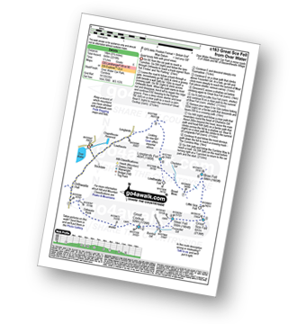
Over Water Reservoir - Waterside Wood - Whitefield Cottage - Binsey Cottage - Binsey - Dogkennel Wood - Overwater Hall - Black Wood - Orthwaite - Orthwaite Bank - Uldale Fells - Great Cockup - Meal Fell - Great Sca Fell - Little Sca Fell - Brae Fell - Broad Moss - Charleton Gill - Langlands Fell - The Cumbria Way - Lowthwaite - Chapelhouse Reservoir - Over Water
|
Vital Statistics:
| Length: | 9 miles (14.5 km) |
| Ascent: | 2,624ft (800m) |
| Time: | 6 hrs |
| Grade: | |
Route Summary:
Over Water - Orthwaite - Orthwaite Bank - Uldale Fells - Great Cockup - Trusmadoor - Meal Fell - Great Sca Fell - Little Sca Fell - Brae Fell - Broad Moss - Lowthwaite Fell - Longlands Fell - The Cumbria Way - Longlands - Lowthwaite - Over Water
Not familiar with the area around CA1?
See these 30 nearest walks to UK Postcode CA1 on a google map
|
Vital Statistics:
| Length: | 7.75 miles (12.5 km) |
| Ascent: | 1,292ft (394m) |
| Time: | 4 hrs |
| Grade: | |
Route Summary:
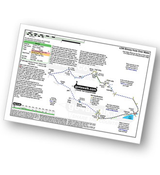
Over Water Reservoir - Binsey Cottage - Binsey - Whittas Park - High House - High Ireby - Ruthwaite - Scawthwaite Mire - Over Water
|
Vital Statistics:
| Length: | 11 miles (17.5 km) |
| Ascent: | 2,288ft (697m) |
| Time: | 6.25hrs |
| Grade: | |
Route Summary:
Melmerby - Meikle Awfell - Cuns Fell - Maiden Way (Roman Road) - Meg's Cairn - Melmerby Fell - Knapside Hill - Little Knapside Hill - Fiend's Fell - Twotop Bridge - Hazel Rigg Farm - Gamblesby - Gill Beck - Melmerby
|
Vital Statistics:
| Length: | 6.28 miles (10 km) |
| Ascent: | 666ft (203m) |
| Time: | 3 hrs |
| Grade: | |
Route Summary:
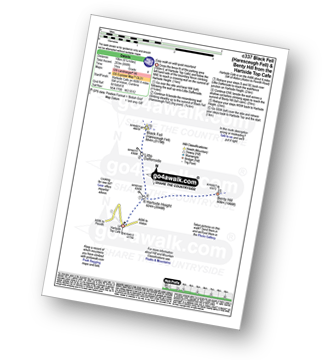
Hartside Top Cafe - Hartside Height - Little Daffenside - Black Fell (Haresceugh Fell) - Little Daffenside - Hartside Height - Benty Hill - Hartside Height - Hartside Top Cafe
|
Vital Statistics:
| Length: | 6.25 miles (10 km) |
| Ascent: | 2,565ft (782m) |
| Time: | 4.75hrs |
| Grade: | |
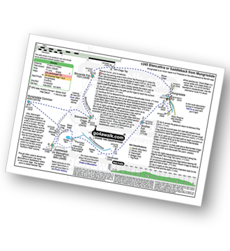
Route Summary:
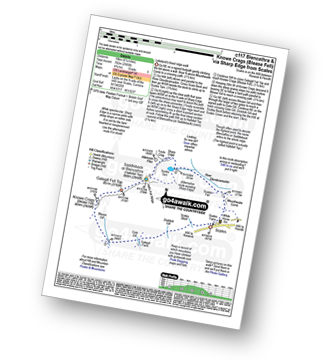
Scales - Mousthwaite Comb - Scales Fell - Brunt Knott - Scales Beck - Scales Tarn - Sharp Edge - Atkinson Pike - Blencathra or Saddleback (Hallsfell Top) - Gategill Fell Top - Knowe Crag (Blease Fell) - Scales
|
Vital Statistics:
| Length: | 5.25 miles (8.5 km) |
| Ascent: | 2,255ft (687m) |
| Time: | 4½ hrs |
| Grade: | |
Route Summary:
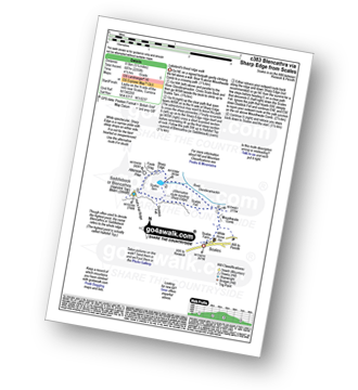
Scales - Mousthwaite Comb - Scales Fell - Brunt Knott - Scales Beck - Scales Tarn - Sharp Edge - Atkinson Pike - Blencathra or Saddleback (Hallsfell Top) - Scales Fell - Mousthwaite Comb - Scales
|
Vital Statistics:
| Length: | 10 miles (16 km) |
| Ascent: | 1,628ft (496m) |
| Time: | 5.25hrs |
| Grade: | |
Route Summary:
Gilderdale Bridge - The Pennine Way - Black Hill (Whitley Common) - Grey Nag - Tom Smith's Stone Top - Tom Smith's Stone - Croglin Water - Haresceugh Fell - Black Fell (Haresceugh Fell) - Woldgill Moss - Gilderdale Burn - Gilderdale Bridge
|
Vital Statistics:
| Length: | 6.25 miles (10 km) |
| Ascent: | 1,325ft (404m) |
| Time: | 3½ hrs |
| Grade: | |
Route Summary:
Gilderdale Bridge - Gilderdale Burn - The Pennine Way - Whitley Castle - Black Hill (Whitley Common) - Grey Nag - Black Hill (Whitley Common) - Whitley Castle - The Pennine Way - Gilderdale Burn - Gilderdale Bridge
|
Vital Statistics:
| Length: | 8.25 miles (13 km) |
| Ascent: | 2,919ft (890m) |
| Time: | 6 hrs |
| Grade: | |
Route Summary:
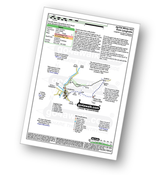
High Side - The Allerdale Ramble - Ling How - The Edge - Ullock Pike - Longside Edge - Long Side - Carl Side - Skiddaw - Bakestall - Birkett Edge - Whitewater Dash - Back O' Skiddaw - Melbecks - High Side
|
Vital Statistics:
| Length: | 12.25 miles (19.5 km) |
| Ascent: | 3,254ft (992m) |
| Time: | 7½ hrs |
| Grade: | |
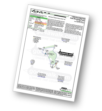
Route Summary:
Brownrigg Farm - Great Mell Fell - Greenrow Great Barn - Lowthwaite - Little Mell Fell - The Hause - Underwood - Cove Park Campsite - Watermillock - Priest's Crag - Great Meldrum - Gowbarrow Fell (Airy Crag) - Norman Crag - Ulcat Row - Matterdale End - Brownrigg Farm
|
Vital Statistics:
| Length: | 3 miles (5 km) |
| Ascent: | 1,145ft (349m) |
| Time: | 2½ hrs |
| Grade: | |
|
Vital Statistics:
| Length: | 3.75 miles (6 km) |
| Ascent: | 2,398ft (731m) |
| Time: | 3.75hrs |
| Grade: | |
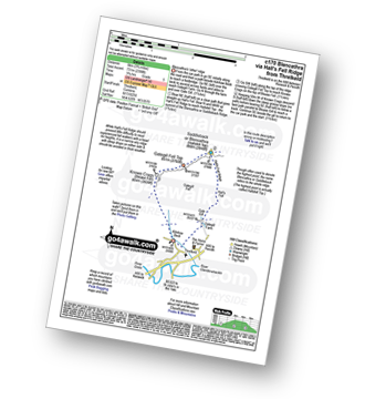
Route Summary:
Threlkeld - Gategill Farm - Hall's Fell - Hall's Fell Ridge - Blencathra or Saddleback (Hallsfell Top) - Gategill Fell Top - Knowe Crags (Blease Fell) - Threlkeld
|
Vital Statistics:
| Length: | 8.5 miles (13.5 km) |
| Ascent: | 804ft (245m) |
| Time: | 4 hrs |
| Grade: | |
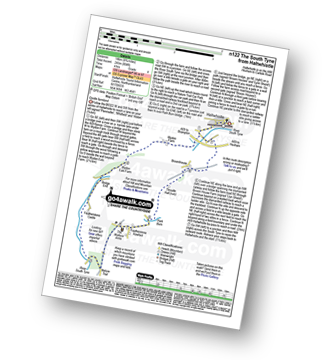
Route Summary:
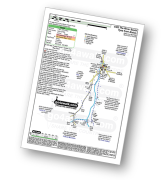
Haltwhistle - Wydon Farm - Wydon Eals Farm - River South Tyne - Featherstone Castle - Lambley Viaduct Nature Trail - Thorneyhole Wood - Featherstone Rowfoot - Park Village - Broomhouse Farm - Haltwhistle
|
Vital Statistics:
| Length: | 1.5 miles (2.5 km) |
| Ascent: | 705ft (215m) |
| Time: | 1½ hrs |
| Grade: |  |
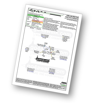
Route Summary:
Cove Park Campsite - Watermillock - Mellfell House - Little Mell Fell - The Hause - Cove Campsite - Watermillock.
|
Vital Statistics:
| Length: | 4.75 miles (7.5 km) |
| Ascent: | 479ft (146m) |
| Time: | 2.25hrs |
| Grade: | |
Route Summary:
Alston - Leadgate - Blackburn Bridge - Bleagate Farm - The Pennine Way - Low Nest Farm - Alston
|
Vital Statistics:
| Length: | 4 miles (6.5 km) |
| Ascent: | 958ft (292m) |
| Time: | 2½ hrs |
| Grade: | |
Route Summary:
Langholm - Ewes Water - River Esk - Whita Hill - Sir John Malcolm Monument Obelsik - Charlie's Moss - Hugh MacDiarmid Memorial - Hillhead - Ewes Water - Langholm
Not familiar with the area around CA1?
See these 30 nearest walks to UK Postcode CA1 on a google map


