7 easy to follow walk route maps of all grades that include part of The High Peak Trail
Seven easy-to-follow walk route maps of all grades that include part of The High Peak Trail in Walk Grade Order
The High Peak Trail is a 29km (18 miles) linear footpath connecting Dowlow in Derbyshire, England with Cromford in Derbyshire, England.
It follows a lengthy section of the Cromford and High Peak Railway which linked the High Peak & Cromford Canals. Started in 1825, the line was finally closed in 1963.
The High Peak Trail is waymarked by named posts.
Tap/mouse over a coloured circle (1-3 easy walks, 4-6 moderate walks, 7-9 hard walks) and click to select.
You can use these checkboxes to show only the grades of walk you are interested in:-
See this list of walks, routes & maps in:
Grade Order | Length Order | Time Order | Walk Number or Start Location Order
NB. To reverse (toggle) this order, click Grade Order again
Scroll down the list of walks below & click on each walk title (in blue) to locate it on the map above.
   |
Vital Statistics:
| Length: | 6 miles (9.5 km) |
| Ascent: | 565ft (172m) |
| Time: | 2.75hrs |
| Grade: |  |
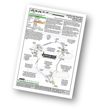
Route Summary:
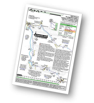
Monyash - Moscar Farm - The High Peak Trail - Parsley Hay - Hardlow - Sparklow - Bull I' Th' Thorn Inn - Newton Farm - Hutmoor Butts - The Limestone Way - Dalehouse Farm - Monyash
|
Vital Statistics:
| Length: | 10.5 miles (16.5 km) |
| Ascent: | 1,287ft (392m) |
| Time: | 5 hrs |
| Grade: |  |
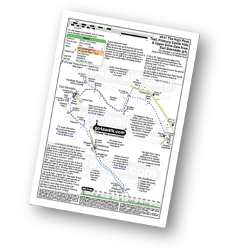
Route Summary:
Earl Sterndale - Hindlow Quarry - Dowlow Works - The Midshires Way - The High Peak Trail - Pomeroy - Hurdlow - Parsley Hay - Darley Farm - Vincent House - Pilsbury - Pilsbury Castle Hills - Upper Dove Dale - Bridge End Farm - Crowdecote - Meadow Farm - Underhill Farm - Hitter Hill - Earl Sterndale
|
Vital Statistics:
| Length: | 9.75 miles (15.5 km) |
| Ascent: | 1,240ft (378m) |
| Time: | 4.75hrs |
| Grade: | |
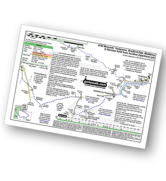
Route Summary:
Middleton-by-Youlgreave - River Bradford - Rusden Wood - Gratton Moor - Long Dale - Bolderstone Plantation - Friden Station - The High Peak Trail - Green Lane (Friden) - Mere Farm - Ringham Low (Friden) - Kenslow Farm - Kenslow Knoll - Little Rockery Plantation - Rake Wood - Middleton-by-Youlgreave
|
Vital Statistics:
| Length: | 15 miles (24 km) |
| Ascent: | 1,831ft (558m) |
| Time: | 7.25hrs |
| Grade: |  |
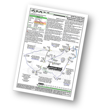
Route Summary:
Hurdlow - Sparklow - The High Peak Trail - Hutmoor Butts - The Limestone Way - Monyash - One Ash Grange Farm - Calling Low Farm - Cales Dale - Moor Lane - Youlgreave - Lomberdale Hall - Middleton-by-Youlgreave - Rake Wood - Little Rookery Plantation - Kenslow Farm - Kenslow Knoll - Ringham Low (Friden) - Mere Farm - Green Lane (Friden) - The High Peak Trail - Sparklow - Hurdlow
|
Vital Statistics:
| Length: | 13.5 miles (21.5 km) |
| Ascent: | 1,286ft (392m) |
| Time: | 6.25hrs |
| Grade: |  |
Route Summary:
Hartington - Sheen - Brund - Manifold Valley - Longnor - Crowdecote (Crowdicote) - Bridge End Farm - Upper Dove Dale - Pilsbury Castle Hills - Vincent House - Darley Farm - The High Peak Trail - Parlsey Hay - The Tissington Trail - Hartington Station - Heathcote - Heathcote Mere - Highfield Lane - Hartington
|
Vital Statistics:
| Length: | 8.75 miles (14 km) |
| Ascent: | 1,171ft (357m) |
| Time: | 4½ hrs |
| Grade: | |
Route Summary:
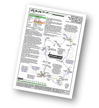
Hartington - Gorsecroft - Madge Dale - Bank Top Farm - Carder Low - Vincent House - Darley Farm - The High Peak Trail - Parsley Hay - The Tissington Trail - Hartington Station - Heathcote - Heathcote Mere - Highfield Lane - Hartington
|
Vital Statistics:
| Length: | 5 miles (8 km) |
| Ascent: | 433ft (132m) |
| Time: | 2 hrs |
| Grade: |  |
Route Summary:
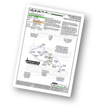
Minninglow - The High Peak Trail - Green Lane - Cobblersnook Lane - Minninglow Lane - The High Peak Trail - Minninglow
See this list of walks, routes & maps in:
Grade Order | Length Order | Time Order | Walk Number or Start Location Order
NB. To reverse (toggle) this order, click Grade Order again


