14 easy to follow walk route maps of all grades that include part of The St Cuthbert's Way
The St Cuthbert's Way is a 100km (62 miles) linear footpath connecting Melrose Abbey in The Borders, Scotland with Holy Island (Lindisfarne) in Northumberland, England.
The St Cuthbert's Way is waymarked by a Celtic Cross.
Not familiar with The St Cuthbert's Way?
See these 14 walks that include part of The St Cuthbert's Way on an interactive Google Map
See this list of walks, routes & maps in:
Grade Order | Length Order | Time Order | Walk Number or Start Location Order
NB. To reverse (toggle) this order, click Grade Order again
   |
Vital Statistics:
| Length: | 8.75 miles (14 km) |
| Ascent: | 1,260 ft (384 m) |
| Time: | 4½ hrs |
| Grade: |  |

Route Summary:
Morebattle - The St Cuthbert's Way - Kale Water - Grubbit Law - Cushat End - Hownam Law - South Cote - Howgate - Heavyside - Gateshaw - Morebattle
|
Vital Statistics:
| Length: | 5 miles (8 km) |
| Ascent: | 180 ft (55 m) |
| Time: | 2 hrs |
| Grade: |  |
Route Summary:
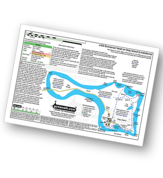
Holy Island (Lindisfarne) Car Park - The Priory - The St Cuthbert's Way - Lindisfarne Castle - Emannuel Head - Holy Island (Lindisfarne) Car Park
|
Vital Statistics:
| Length: | 7.5 miles (12 km) |
| Ascent: | 1,257 ft (383 m) |
| Time: | 4½ hrs |
| Grade: | |

Route Summary:
Wooler - The St Cuthbert's Way - Waud House - Kenterdale Hill - Wooler Common - Switcher Wood - Earlhillhead Farm - Carey Burn - Careyburn Bridge - Harthope Burn - Colgate Water (High Level Route) - Happy Valley - Middleton Old Town - North Middleton - Colgate Mill - Colgate Water - Earle Mill - Wooler Water - Wooler
|
Vital Statistics:
| Length: | 7.25 miles (11.5 km) |
| Ascent: | 1,165 ft (355 m) |
| Time: | 3.75 hrs |
| Grade: |  |
Route Summary:
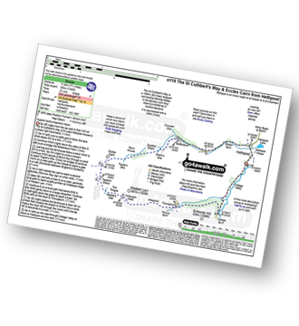
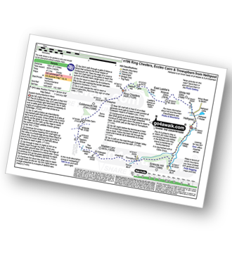
Hethpool - The St Cuthbert's Way - Elsdon Burn - Elsdonburn Farm - Shank's Sike - Scaldhill Shank - Tom's Knowe - Tuppie's Sike - Eccles Cairn - England / Scotland Border - The Pennine Way - Tuppie's Grave - The Tongue - Maddie's Well - Madam Law - Wideopen Head - Trowup Burn - Trowupburn - College Valley - College Burn - Hethpool
|
Vital Statistics:
| Length: | 8.5 miles (13.5 km) |
| Ascent: | 1,093 ft (333 m) |
| Time: | 4.25 hrs |
| Grade: | |

Route Summary:
Wooler - The St Cuthbert's Way - Weetwood Bank - Weetwood Moor - River Till - Weetwood Bridge - Weetwood Hall - Weetwood Hill - Broomy Knowe - Shepherds House - Dod Law - Doddington Moor - Doddington - Milfield Plain - Doddington Bridge - Turvelaws Farm - Wooler
|
Vital Statistics:
| Length: | 5 miles (8 km) |
| Ascent: | 1,021 ft (311 m) |
| Time: | 3 hrs |
| Grade: |  |

Route Summary:
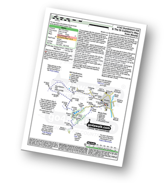
Hethpool - The St Cuthbert's Way - White Hill (Hethpool) - East Laddie's Knowe - Laddie's Knowe or Betsy's Cairn - Black Bog (Haddon Hill) - Haddon Hill - Ring Chesters - Elsdonburn Farm - Elsdon Burn - The St Cuthbert's Way - Hethpool
|
Vital Statistics:
| Length: | 5.75 miles (9 km) |
| Ascent: | 1,214 ft (370 m) |
| Time: | 3½ hrs |
| Grade: | |
Route Summary:
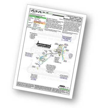
Wooler - Gallowlaw Gallowlaw Hill - Humbleton - Humbleton Hill - Brown's Law - Wooler Common and Woodland Park - The St Cuthbert's Way - Kenterdale Hill - Waud House - Wooler
|
Vital Statistics:
| Length: | 6.5 miles (10.5 km) |
| Ascent: | 1,043 ft (318 m) |
| Time: | 3½ hrs |
| Grade: | |

Route Summary:
Wooler - The St Cuthbert's Way - Waud House - Kenterdale Hill - Wooler Common - Switcher Wood - Earlhillhead Farm - Carey Burn - Careyburn Bridge - Harthope Burn - Colgate Water (Low Level Route) - Skirl Naked - Grimping Haugh - Broom Crook Plantation - Happy Valley - Careyburn Bridge - Colgate Mill - Earle Mill - Wooler Water - Wooler
|
Vital Statistics:
| Length: | 7.5 miles (12 km) |
| Ascent: | 1,316 ft (401 m) |
| Time: | 4 hrs |
| Grade: | |

Route Summary:
Hethpool - The St Cuthbert's Way - White Hill (Hethpool) - East Laddie's Knowe - Laddie's Knowe or Betsy's Cairn - Black Bog (Haddon Hill) - Haddon Hill - Ring Chesters - Sheepfold - Eccles Cairn - England / Scotland Border - Elsdonnurn Farm - Elsdon Burn - The St Cuthbert's Way - Hethpool
|
Vital Statistics:
| Length: | 3.25 miles (5 km) |
| Ascent: | 525 ft (160 m) |
| Time: | 1.75 hrs |
| Grade: |  |
Route Summary:
Wooler - The St Cuthbert's Way - Waud House - Kenterdale Hill - Wooler Common and Woodland Park - Wooler
|
Vital Statistics:
| Length: | 10.25 miles (16.5 km) |
| Ascent: | 1,182 ft (360 m) |
| Time: | 5 hrs |
| Grade: | |

Route Summary:
Wooler - The St Cuthbert's Way - Weetwood Bank - Weetwood Moor - River Till - Weetwood Bridge - Weetwood Hall - Weetwood Hill - Broomy Knowe - Shepherds House - Dod Law (Doddington Moor) - Doddington Moor - Doddington - River Till - St Cuthbert's Bridge - Milfield Plain - River Glen - Bridge End - Bowchester - Low Humbleton - Gallowlaw Hill - Gallowlaw - Wooler
|
Vital Statistics:
| Length: | 8.25 miles (13 km) |
| Ascent: | 1,483 ft (452 m) |
| Time: | 4½ hrs |
| Grade: | |
Route Summary:
Hethpool - The St Cuthbert's Way - White Hill (Hethpool) - East Laddie's Knowe - Laddie's Knowe or Betsy's Cairn - Black Bog (Haddon Hill) - Haddon Hill - Ring Chesters - Sheepfold - Eccles Cairn - England / Scotland Border - The Pennine Way - Tuppie's Grave - The Tongue - Maddie's Well - Madam Law - Wideopen Head - Trowup Burn - Trowupburn - College Valley - College Burn - Hethpool
|
Vital Statistics:
| Length: | 13.75 miles (22 km) |
| Ascent: | 2,665 ft (812 m) |
| Time: | 7.75 hrs |
| Grade: |  |

Route Summary:
Hethpool - The St Cuthbert's Way - Elsdon Burn - Elsdonburn Farm - Shank's Sike - Scaldhill Shank - Tom's Knowe - Tuppie's Sike - Eccles Cairn - England / Scotland Border - The Pennine Way - White Law - Steel Rig - Black Hag (Hethpool) - The Schil - Birnie Brae - Red Cribs - Mounthooly - Fleehope - Whitehall - College Valley - Hethpool
|
Vital Statistics:
| Length: | 10.75 miles (17 km) |
| Ascent: | 1,746 ft (532 m) |
| Time: | 5.75 hrs |
| Grade: |  |

Route Summary:
Wooler - The St Cuthbert's Way - Waud House - Kenterdale Hill - Wooler Common - Carey Burn - Broadstruthers Burn - Commonburn House - Wackerage Cairn - Tom Tallon's Crag - The St Cuthbert's Way - Gleadscleugh - Akeld Burn - Humbleton - Gallowlaw - Wooler
See this list of walks, routes & maps in:
Grade Order | Length Order | Time Order | Walk Number or Start Location Order
NB. To reverse (toggle) this order, click Grade Order again
Not familiar with The St Cuthbert's Way?
See these 14 walks that include part of The St Cuthbert's Way on an interactive Google Map


