2 easy to follow walk route maps of all grades that include part of The South Cheshire Way
The South Cheshire Way is a 53km (33 miles) linear footpath connecting Mow Cop in Cheshire, England with Grindley Brook in Staffordshire, England.
The South Cheshire Way is waymarked by by the letters SCW.
Not familiar with The South Cheshire Way?
See these 2 walks that include part of The South Cheshire Way on an interactive Google Map
   |
Vital Statistics:
| Length: | 5.5 miles (9 km) |
| Ascent: | 689ft (215m) |
| Time: | 2.75hrs |
| Grade: |  |
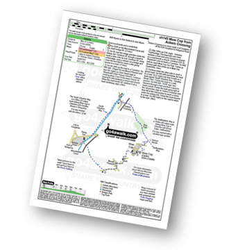
Route Summary:
Ackers Crossing - The Macclesfield Canal - The Cheshire Ring Canal Walk - Scholar Green - Mount Pleasant - Mow Cop (Old Man of Mow) - The Gritstone Trail - The Staffordshire Way - The South Cheshire Way - Quarry Wood - Hanging Wood - Roe Park - Ackers Crossing
|
Vital Statistics:
| Length: | 8.25 miles (13 km) |
| Ascent: | 804ft (245m) |
| Time: | 3.75hrs |
| Grade: |  |
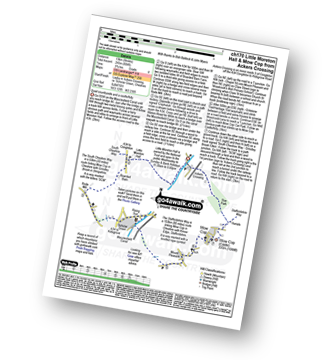
Route Summary:
Ackers Crossing - The Macclesfield Canal - The Cheshire Ring Canal Walk - Little Moreton Hall - Boarded Barn Farm - Rode Mill - Claphatches - Scholar Green - Mount Pleasant - Mow Cop (Old Man of Mow) - The Gritstone Trail - The Staffordshire Way - The South Cheshire Way - Quarry Wood - Hanging Wood - Roe Park - Ackers Crossing
Not familiar with The South Cheshire Way?
See these 2 walks that include part of The South Cheshire Way on an interactive Google Map


