35 easy to follow walk route maps of all grades that include part of The South West Coast Path
The South West Coast Path is a 966km (600 miles) linear footpath connecting Minehead in Somerset, England with South Haven Point in Dorset, England.
The South West Coast Path is waymarked by a National Trail Acorn.
Not familiar with The South West Coast Path?
See these 35 walks that include part of The South West Coast Path on an interactive Google Map
See this list of walks, routes & maps in:
Grade Order | Length Order | Time Order | Walk Number or Start Location Order
NB. To reverse (toggle) this order, click Grade Order again
   |
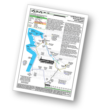
Vital Statistics:
| Length: | 6 miles (9.5 km) |
| Ascent: | 1,382 ft (421 m) |
| Time: | 3.75 hrs |
| Grade: |  |

Route Summary:
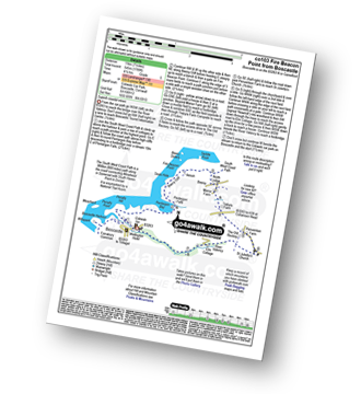
Cawsand - The South West Coast Path - Cawsand Bay - Pier Cellars - Penlee Point - Homebarton Hill - Rame Head - Queener Point - Polhawn Cove - Captain Blake's Point - Wiggle Cliff - Wiggle - Wringford Downs Cawsand.
|
Vital Statistics:
| Length: | 7 miles (11 km) |
| Ascent: | 1,789 ft (545 m) |
| Time: | 4½ hrs |
| Grade: |  |
Route Summary:
Boscastle - The South West Coast Path - River Valency - Boscastle Harbour - Penally Point - Penally Hill - Pentargon Bay - Pentargon Falls - Beeny Cliff - Seals Hole - Fire Beacon Point - Beeny - Trebyla Farm - Penvention Farm - St Julietta's Church - River Valency - Boscastle
|
Vital Statistics:
| Length: | 5.5 miles (9 km) |
| Ascent: | 1,208 ft (368 m) |
| Time: | 3½ hrs |
| Grade: | |

Route Summary:
Trebetherick - The South West Coast Path - Polzeath - New Polzeath - Slipper Point - Pentireglaze Haven - Pentire Point - Pentire Head - Guglane - Rumps Point - Sandinway Beach - Com Head - Pengrit Cove - Downhedge Cove - Pentireglaze - Polzeath - Trebetherick
|
Vital Statistics:
| Length: | 4.75 miles (7.5 km) |
| Ascent: | 876 ft (267 m) |
| Time: | 2½ hrs |
| Grade: |  |

Route Summary:
West Pentire - The South West Coast Path - Pentire Point West - Porth Joke - Kelsey Head - Holywell Bay - Holywell Beach - Holywell - The Kelseys - Cuthbert Common - West Pentire
|
Vital Statistics:
| Length: | 5.25 miles (8.5 km) |
| Ascent: | 1,260 ft (384 m) |
| Time: | 3.25 hrs |
| Grade: | |

Route Summary:
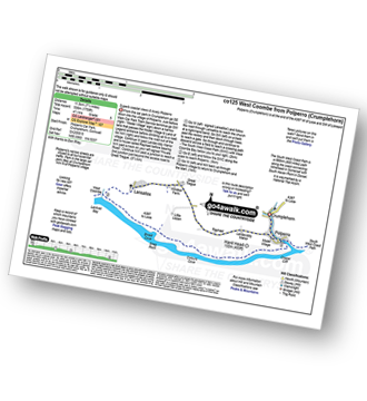
Crumplehorn - Longcoombe Mill - Watergate House - Sclerder Abbey - Porthallow - Talland Bay - The South West Coast Path - Downend Point - Polperro - Crumplehorn
|
Vital Statistics:
| Length: | 5.5 miles (9 km) |
| Ascent: | 700 ft (213 m) |
| Time: | 2.75 hrs |
| Grade: | |

Route Summary:
Perranuthnoe - The South West Coast Path - Perran Sands - Maen-du-Point - The Greeb - Basore Point - Trenow Cove - Venton Farm - Chymorvah East - Marazion - The Causeway - St Michael's Mount - He Causeway - Marazion - Trenow Farm - Perranuthnoe
|
Vital Statistics:
| Length: | 5 miles (8 km) |
| Ascent: | 955 ft (291 m) |
| Time: | 3 hrs |
| Grade: | |

Route Summary:
Land's End - The South West Coast Path - Mill Bay (Nanjizal) - Trevilley - Trevescan - Sennen - Sennen Cove - Land's End
|
Vital Statistics:
| Length: | 11.25 miles (18 km) |
| Ascent: | 3,197 ft (974 m) |
| Time: | 7½ hrs |
| Grade: |  |
Route Summary:
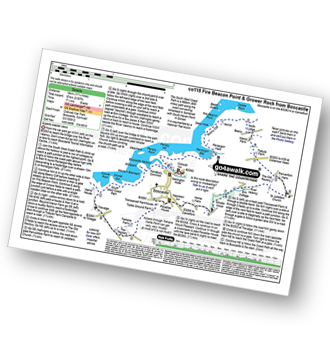
Boscastle - The South West Coast Path - River Valency - Boscastle Harbour - Penally Point - Penally Hill - Pentargon Bay - Pentargon Falls - Beeny Cliff - Seals Hole - Fire Beacon Point - Beeny - Trebyla Farm - Penvention Farm - St Julietta's Church - River Valency - Minster Wood - Upper Boscastle - Trehane Farm - Trevalga - The South West Coast Path - Grower Rock - Grower Gut - Western Blackapit - Willapark - Boscastle Harbour - Boscastle
|
Vital Statistics:
| Length: | 7.5 miles (12 km) |
| Ascent: | 1,533 ft (467 m) |
| Time: | 4.25 hrs |
| Grade: | |

Route Summary:
Millpool Car Park - West Looe - East Looe - The South West Coast Path - Hannafore Point - Portnadler Bay - Hore Stone - Talland Bay - Talland Church - Tencreek Campsite - Parkers Cross - Kilminorth - Watergate - West Looe River - Kilminorth Wood - West Looe - East Looe.
|
Vital Statistics:
| Length: | 4 miles (6.5 km) |
| Ascent: | 391 ft (119 m) |
| Time: | 2 hrs |
| Grade: |  |

Route Summary:
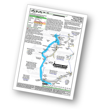
Daymer Bay (Trebetherick) - The South West Coast Path - Brea Hill - Rock (Padstow Bay) - St Endoc Golf Course - St Endoc Church - Daymer Bay (Trebetherick)
|
Vital Statistics:
| Length: | 8 miles (12 km) |
| Ascent: | 1,759 ft (536 m) |
| Time: | 4½ hrs |
| Grade: | |
Route Summary:
Crumplehorn - Polperro - Landaviddy Manor - Raphael - Great Tregue - Lansallos - West Coombe - The South West Coast Path - East Coombe - Broad Cove - Shag Rock - Colours Cove - Chapel Cliff - Polperro - Crumplehorn
|
Vital Statistics:
| Length: | 11.75 miles (19 km) |
| Ascent: | 1,867 ft (569 m) |
| Time: | 6.25 hrs |
| Grade: |  |
Route Summary:
Rock (Padstow Bay) - The South West Coast Path - Brea Hill - Daymer Bay (Trebetherick) - Trebetherick Point - Greenaway Beach - Broadagogue Cove - Hayle Bay - Trebetherick - Polzeath - New Polzeath - Slipper Point - Pentireglaze Haven - Pentire Point - Pentire Head - Guglane - Rumps Point - Sandinway Beach - Com Head - Pengrit Cove - Downhedge Cove - Pentireglaze - Portkillock Farm - Roserrow - Pityme - Splatt - Stoptide - Rock (Padstow Bay)
|
Vital Statistics:
| Length: | 5 miles (8 km) |
| Ascent: | 952 ft (290 m) |
| Time: | 2.75 hrs |
| Grade: | |
Route Summary:
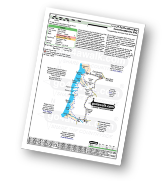
Constantine Bay - The South West Coast Path - Treyarnon Point - Treyarnon Bay - Trethias Island - Pepper Cove - Warren Cove - Fox Cove - Minnows Islands - Will's Rock - Porthcothan Bay - Carnevas - Trethias Farm - Treyarnon Farm - Constantine Bay
|
Vital Statistics:
| Length: | 4.5 miles (7 km) |
| Ascent: | 748 ft (228 m) |
| Time: | 2½ hrs |
| Grade: | |
Route Summary:
Pentire Farm - Porth Mear - The South West Coast Path - High Cove - Park Head - Mackerel Cove - Pentire Steps - Diggory's Island - Bedruthan Steps - Pendarve Point - Whitestone Cove - Bedruthan Steps Visitor Centre - B3276 - Pentire Farm
|
Vital Statistics:
| Length: | 8.25 miles (13.5 km) |
| Ascent: | 958 ft (292 m) |
| Time: | 4 hrs |
| Grade: | |
Route Summary:
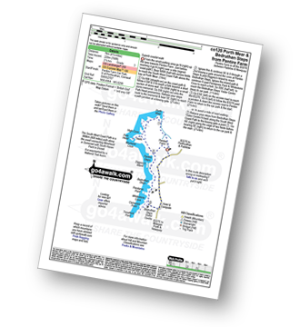
Daymer Bay (Trebetherick) - The South West Coast Path - Trebetherick Point - Greenaway Beach - Broadagogue Cove - Hayle Bay - Trebetherick - Polzeath - New Polzeath - Slipper Point - Pentireglaze Haven - Pentireglaze - Portkillock Farm - Roserrow - Pityme - Splatt - Stoptide - Rock (Padstow Bay) - St Endoc Church - Daymer Bay (Trebetherick)
|
Vital Statistics:
| Length: | 5.5 miles (9 km) |
| Ascent: | 1,407 ft (448 m) |
| Time: | 3½ hrs |
| Grade: | |

Route Summary:
Crumplehorn - Polperro - Landaviddy Manor - Raphael - Little Lizzen - East Coombe - The South West Coast Path - East Coombe - Broad Cove - Shag Rock - Colours Cove - Chapel Cliff - Polperro - Crumplehorn
|
Vital Statistics:
| Length: | 6.5 miles (10 km) |
| Ascent: | 755 ft (230 m) |
| Time: | 3 hrs |
| Grade: | |
Route Summary:
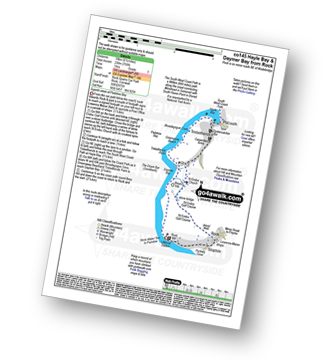
Rock (Padstow Bay) - Porthilly Cove - Stoptide - Rock (Padstow Bay) - St Endoc Golf Course - St Endoc Church - Trebetherick - The South West Coast Path - Broadagogue Cove - Greenaway Beach - Padstow Bay - Daymer Bay (Trebetherick) - Brea Hill - Rock (Padstow Bay)
|
Vital Statistics:
| Length: | 6.25 miles (10 km) |
| Ascent: | 1,122 ft (342 m) |
| Time: | 3½ hrs |
| Grade: | |

Route Summary:
Millpool Car Park - West Looe - East Looe - The South West Coast Path - Hannafore Point - Portnadler Bay - Hore Stone - Talland Bay - Talland Church - Tencreek Campsite - Portlooe - West Looe - East Looe.
|
Vital Statistics:
| Length: | 6.75 miles (11 km) |
| Ascent: | 1,234 ft (376 m) |
| Time: | 3.75 hrs |
| Grade: | |

Route Summary:
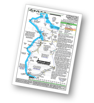
Tintagel - Fenterleigh - St Nectan's Glen - St Piran's Church - Trethevey - Trevalga - The South West Coast Path - Ladies Window - Trevalga Cliff - Trewthet Gut - Trewethett Mill - Rocky Valley - Benoath Cove - Bossiney Haven - Gullastern - Smith Cliff - Barras Gut - Barras Nose - Tintagel Haven - Tintagel Castle - Tintagel Head - Tintagel
|
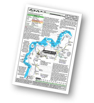
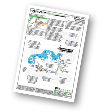
Vital Statistics:
| Length: | 6.25 miles (10 km) |
| Ascent: | 945 ft (288 m) |
| Time: | 3.25 hrs |
| Grade: | |

Route Summary:
Padstow - Padstow Harbour - The South West Coast Path - St Saviour's Point - St George's Cove - Gun Point - Harbour Cove - Hawker's Cove - The Narrows - Old Boad - Stepper Point - Stepper Point Beacon - Crams - Pepper Hole - Butter Hole - Ginver Head - Middle Merope Islands - Crugmeer - Tregirls Farm - Prideaux Place - Padstow - Padstow Harbour.
|
Vital Statistics:
| Length: | 6.25 miles (10 km) |
| Ascent: | 1,729 ft (527 m) |
| Time: | 4 hrs |
| Grade: | |

Route Summary:
Boscastle - River Valency - Minster Wood - Upper Boscastle - Trehane Farm - Trevalga - The South West Coast Path - Grower Rock - Grower Gut - Western Blackapit - Willapark - Boscastle Harbour - Boscastle
|
Vital Statistics:
| Length: | 7 miles (11 km) |
| Ascent: | 1,086 ft (331 m) |
| Time: | 3.75 hrs |
| Grade: | |

Route Summary:
Mawgan Porth - Bracken Cott - Vale of Mawgan - St Mawgan - Trevarrian - Tregurrian - Watergate Bay - The South West Coast Path - Ontonna Rock - Stem Point - Griffin's Point - Beacon Cove - Berryl's Point - Butt Rock - Grange Point - Mawgan Porth
|
Vital Statistics:
| Length: | 7.75 miles (12.5 km) |
| Ascent: | 1,306 ft (398 m) |
| Time: | 4.25 hrs |
| Grade: | |
Route Summary:
Holywell - Ellenglaze - Trebisken House - Mount Farm - Penhale Sands (Dunes) - St Prian's Church (Penhale Sands) - St Piran's Oratory (Penhale Sands) - The South West Coast Path - Perran Beach - Liggar Bay - Perran Bay - Liggar Point - Hoblyn's Cove - Penhale Point - Holywell Bay - Holywell
|
Vital Statistics:
| Length: | 10.75 miles (17 km) |
| Ascent: | 1,983 ft (568 m) |
| Time: | 5.75 hrs |
| Grade: | |
Route Summary:
Tintagel - Fenterleigh - St Nectan's Glen - St Piran's Church - Trethevey - Trevalga - The South West Coast Path - Ladies Window - Trevalga Cliff - Trewthet Gut - Trewethett Mill - Rocky Valley - Benoath Cove - Bossiney Haven - Gullastern - Smith Cliff - Barras Gut - Barras Nose - Tintagel Haven - Tintagel Head - Glebe Cliff - Dunderhole Point - Penhallic Point - Hole Beach - Trebarwith Sands - Trelake - Treknow - Two Acre Farm - Tintagel
|
Vital Statistics:
| Length: | 5 miles (8 km) |
| Ascent: | 1,096 ft (334 m) |
| Time: | 3 hrs |
| Grade: | |
Route Summary:
Tintagel - Fenterleigh - St Nectan's Glen - St Piran's Church - Trethevey - Trevelleit Mill - Trewethett Mill - Rocky Valley - The South West Coast Path - Benoath Cove - Bossiney Haven - Gullastern - Smith Cliff - Barras Gut - Barras Nose - Tintagel Haven - Tintagel Castle - Tintagel Head - Tintagel
|
Vital Statistics:
| Length: | 5.5 miles (8.5 km) |
| Ascent: | 1,493 ft (455 m) |
| Time: | 3½ hrs |
| Grade: | |

Route Summary:
Lynton - The Danes Or Valley Of Rocks - Six Acre Wood - The South West Coast Path - Lee Bay - Lee Abbey - Castle Rock - Rugged Jack - Wringcliff Bay - Ruddy Ball - Lynmouth - Lynton
|
Vital Statistics:
| Length: | 6.25 miles (10 km) |
| Ascent: | 998 ft (304 m) |
| Time: | 3.25 hrs |
| Grade: | |

Route Summary:
Slapton Sands - The South West Coast Path - Slapton Ley - Start Bay - Lower Ley - Torcross - Limpet Rocks - Widdecombe House - Stokenham - Frittiscombe - Deer Bridge - Slapton Sands
|
Vital Statistics:
| Length: | 5.25 miles (8.5 km) |
| Ascent: | 1,234 ft (376 m) |
| Time: | 3.25 hrs |
| Grade: | |

Route Summary:
Durdle Door Car Park - Daggers Gate - The Warren - Chaldon Down - The South West Coast Path - West Bottom - Middle Bottom - Bat's Hole - Bat's Head - The Jurassic Coast - Swyre Head - Scratchy Bottom - Durdle Door - Durdle Door Car Park
|
Vital Statistics:
| Length: | 6.25 miles (10 km) |
| Ascent: | 994 ft (303 m) |
| Time: | 3.25 hrs |
| Grade: | |

Route Summary:
Abbotsbury - The Macmillan Way - Abbotsbury Plain - The South Dorset Ridgeway - Abbotsbury Castle (Iron Age Fort) - Tulks Hill - Labour in Vain Farm - East Bexington Farm - The South West Coast Path - Chesil Beach - Abbotsbury
|
Vital Statistics:
| Length: | 9.5 miles (15 km) |
| Ascent: | 1,388 ft (423 m) |
| Time: | 5 hrs |
| Grade: | |

Route Summary:
Worth Matravers - Swanworth Quarry - The Purbeck Way - Coomb Bottom - Corfe Common - Corfe Castle - Corfe Common - Kingston - Houns-tout-Cliffs - The South West Coast Path - North Hill - West Hill - Renscombe Farm - Worth Matravers
|
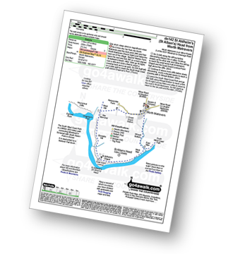
Vital Statistics:
| Length: | 4.75 miles (7.5 km) |
| Ascent: | 811 ft (247 m) |
| Time: | 2½ hrs |
| Grade: | |

Route Summary:
West Bexington - Tulks Hill - Abbotsbury Castle (Iron Age Fort) - The South West Coast Path - Chesil Beach - West Bexington
|
Vital Statistics:
| Length: | 9 miles (14.5 km) |
| Ascent: | 1,191 ft (363 m) |
| Time: | 4½ hrs |
| Grade: | |

Route Summary:
Lulworth Cove - West Lulworth - Durdle Door Caravan Park - Newlands Farm - Daggers Gate - The Warren - Chaldon Down - Ringstead Bay - The Jurassic Coast - The South West Coast Path - White Nothe - Whitenothe Cottage - West Bottom - Middle Bottom - Bats Hole - Bats Head - Swyre Head - Scratchy Bottom - Durdle Door - St Oswald's Bay - Hambury Tout - Dungy Head - Stair Hole - Lulworth Cove
|
Vital Statistics:
| Length: | 8.25 miles (13 km) |
| Ascent: | 1,070 ft (326 m) |
| Time: | 4 hrs |
| Grade: | |

Route Summary:
Abbotsbury - The Macmillan Way - Abbotsbury Plain - The South Dorset Ridgeway - Abbotsbury Castle (Iron Age Fort) - Tulks Hill - West Bexington - The South West Coast Path - Chesil Beach - Abbotsbury
|
Vital Statistics:
| Length: | 4.75 miles (7.5 km) |
| Ascent: | 754 ft (230 m) |
| Time: | 2½ hrs |
| Grade: | |
Route Summary:
Worth Matravers - The South West Coast Path - Emmetts Hill - St Aldhelm's (St Alban's) Head - St Aldhelm's Chapel - National Coastwatch Station St Alban's Head - West Man - Winspit - Winspit Bottom - Worth Matravers
|
Vital Statistics:
| Length: | 6 miles (9.5 km) |
| Ascent: | 1,408 ft (429 m) |
| Time: | 3½ hrs |
| Grade: | |

Route Summary:
Bossington - Allerford - Selworthy - Selworthy Beacon - The South West Coast Path - Hurlstone Combe - Hurlstone Point - Porlock Bay - Bossington
See this list of walks, routes & maps in:
Grade Order | Length Order | Time Order | Walk Number or Start Location Order
NB. To reverse (toggle) this order, click Grade Order again
Not familiar with The South West Coast Path?
See these 35 walks that include part of The South West Coast Path on an interactive Google Map


