10 easy to follow walk route maps of all grades that include part of The Ridgeway
The Ridgeway is a 137km (85 miles) linear footpath connecting Overton in Wiltshire, England with Ivinghoe Beacon in Buckinghamshire, England.
The Ridgeway is waymarked by a National Trail Acorn.
Not familiar with The Ridgeway?
See these 10 walks that include part of The Ridgeway on an interactive Google Map
See this list of walks, routes & maps in:
Grade Order | Length Order | Time Order | Walk Number or Start Location Order
NB. To reverse (toggle) this order, click Grade Order again
   |
Vital Statistics:
| Length: | 4.5 miles (7 km) |
| Ascent: | 693 ft (211 m) |
| Time: | 2½ hrs |
| Grade: |  |

Route Summary:
Great Kimble - The North Bucks Way - Askett - Monks Risborough - Whiteleaf - The Icknield Way - The Ridgeway - Whiteleaf Cross - Cadsden - Grangelands And Pulpit Hill Nature Reserve - Chequer's Knap - The North Bucks Way - Great Kimble
|
Vital Statistics:
| Length: | 5.5 miles (9 km) |
| Ascent: | 853 ft (260 m) |
| Time: | 3 hrs |
| Grade: | |

Route Summary:
Butler's Cross - Monument Hill (Coombe Hill) - The Ridgeway - Linton's Wood - Goodmerhill Wood - Chisley Wood - The Icknield Way - Chequers - Pond Wood - Pulpit Wood - The North Bucks Way - The Midshires Way - Chequers Knap - Whorley Wood - Ellesborough Warren - Boxtree Wood - Beacon Hill (Ellesborough) - Ellesborough - The Aylesbury Ring - Springs Farm - Butler's Cross
|
Vital Statistics:
| Length: | 6 miles (9.5 km) |
| Ascent: | 528 ft (161 m) |
| Time: | 2.75 hrs |
| Grade: | |
Route Summary:
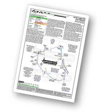
Bledlow - The Midshires Way - The Warren - The Ridgeway - Thickthorn Wood - Lodge Hill - Longwood Farm - The Old Rectory - Saunderton - Horsenden - Bledlow
|
Vital Statistics:
| Length: | 6.5 miles (10 km) |
| Ascent: | 722 ft (220 m) |
| Time: | 3 hrs |
| Grade: | |

Route Summary:
Dagnall - Chlitern Farm - Former Radio Station - Gallows Hill - Ivinghoe Beacon - The Ridgeway - Ivinghoe Hills - Steps Hill - Down Farm - Clipperdown Cottage - Clipper Down - Ward's Hurst Farm - Hog Hall - Hog Hall Lane - Dagnall
|
Vital Statistics:
| Length: | 7.25 miles (11.5 km) |
| Ascent: | 847 ft (258 m) |
| Time: | 3½ hrs |
| Grade: |  |
Route Summary:
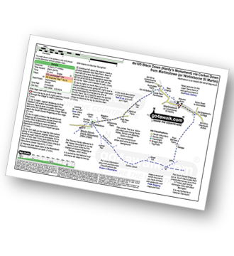
Martinstown (or Winterborne St Martin) - Four Barrows Farm - Great Hill - South Dorset Ridgeway - Corton Down - Bronkham Hill - Jubilee Trail - Blackdown - Smitten Corner - Black Down (Hardy Monument) - East Rew Farm - Rew Manor - Martinstown (or Winterboune St Martin).
|
Vital Statistics:
| Length: | 6.25 miles (10 km) |
| Ascent: | 994 ft (303 m) |
| Time: | 3.25 hrs |
| Grade: | |

Route Summary:
Abbotsbury - The Macmillan Way - Abbotsbury Plain - The South Dorset Ridgeway - Abbotsbury Castle (Iron Age Fort) - Tulks Hill - Labour in Vain Farm - East Bexington Farm - The South West Coast Path - Chesil Beach - Abbotsbury
|
Vital Statistics:
| Length: | 7 miles (11 km) |
| Ascent: | 1,037 ft (316 m) |
| Time: | 3½ hrs |
| Grade: | |

Route Summary:
Martinstown (or Winterborne St Martin) - Grove Hill Bottom - Great Hill - South Dorset Ridgeway - Corton Down - Bronkham Hill - Jubilee Trail - Blackdown - Smitten Corner - Black Down (Hardy Monument) - Bronkham Hill - Pen Barn Farm - Grove Hill Bottom - Martinstown (or Winterborne St Martin)
|
Vital Statistics:
| Length: | 7.25 miles (11.5 km) |
| Ascent: | 1,158 ft (353 m) |
| Time: | 3.75 hrs |
| Grade: | |

Route Summary:
Abbotsbury - The Macmillan Way - Abbotsbury Plains - Borad Coppice - Gorwell Farm - Kingstone Russel Stone Circle - Tenants Hill - Littlebredy - Topparts Dairy - The South Dorset Ridgeway - White Hill (Abbotsbury) - Abbotsbury
|
Vital Statistics:
| Length: | 8.25 miles (13 km) |
| Ascent: | 1,070 ft (326 m) |
| Time: | 4 hrs |
| Grade: | |

Route Summary:
Abbotsbury - The Macmillan Way - Abbotsbury Plain - The South Dorset Ridgeway - Abbotsbury Castle (Iron Age Fort) - Tulks Hill - West Bexington - The South West Coast Path - Chesil Beach - Abbotsbury
|
Vital Statistics:
| Length: | 8.5 miles (13.5 km) |
| Ascent: | 873 ft (266 m) |
| Time: | 4 hrs |
| Grade: | |

Route Summary:
Aldbourne - The Giant's Grave - Upper Upham - The Ridgeway - Sugar Hill - Four Barrows - Aldbourne
See this list of walks, routes & maps in:
Grade Order | Length Order | Time Order | Walk Number or Start Location Order
NB. To reverse (toggle) this order, click Grade Order again
Not familiar with The Ridgeway?
See these 10 walks that include part of The Ridgeway on an interactive Google Map


