8 easy to follow walk route maps of all grades that include part of The Longdendale Trail
The Longdendale Trail is an 11km (7 miles) linear footpath connecting Hadfield in Derbyshire, England with Salter's Brook on the border with West Yorkshire, England.
The Longdendale Trail also forms part of the Trans Pennine Trail that runs coast to coast across the UK from Southport in Merseyside to Hornsea in The East Riding of Yorkshire.The Longdendale Trail follows part of the former Great Central Railway. This line from Manchester to Sheffield Railway was also known as 'The Woodhead Route'. It passed through the picturesque Longdendale valley which includes five reservoirs surrounded by high moorland. The reservoirs were completed in 1877 & were, at the time, the largest artificial expanse of water in the world. The line itself was closed in 1981 amid much controversy.
The Longdendale Trail is waymarked by named discs.
Not familiar with The Longdendale Trail?
See these 8 walks that include part of The Longdendale Trail on an interactive Google Map
See this list of walks, routes & maps in:
Grade Order | Length Order | Time Order | Walk Number or Start Location Order
NB. To reverse (toggle) this order, click Grade Order again
   |
Vital Statistics:
| Length: | 5.25 miles (8.5 km) |
| Ascent: | 823ft (251m) |
| Time: | 2.75hrs |
| Grade: |  |
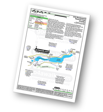
Route Summary:
Crowden - The Pennine Way - Torside Reservoir - Rhodeswood Reservoir - The Longdendale Trail - The Pennine Way - Torside Reservoir - Crowden
|
Vital Statistics:
| Length: | 13.25 miles (21 km) |
| Ascent: | 2,081ft (634m) |
| Time: | 7 hrs |
| Grade: |  |
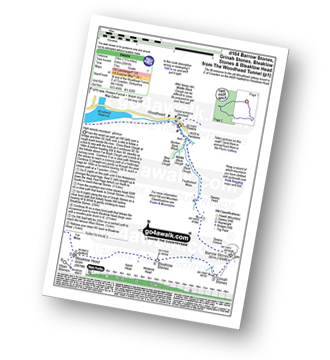
Route Summary:
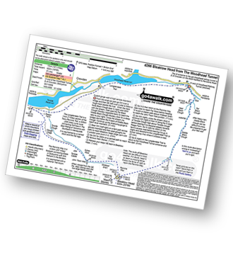
Woodhead Tunnel - Far Black Clough - Swains Head - Swains Greave - Barrow Stones - Grinah Stones - Bleaklow Stones (Bleaklow Hill) - Bleaklow Head (Bleaklow Hill) - The Wain Stones (or Kissing Stones) - The Pennine Way - Joseph Patch - John Track Well - Torside Clough - Peaknaze Moor - Reaps Farm - The Longdendale Trail - Torside Reservoir - Woodhead Reservoir - Woodhead Tunnel
|
Vital Statistics:
| Length: | 6.25 miles (10 km) |
| Ascent: | 1,610ft (491m) |
| Time: | 4 hrs |
| Grade: |  |
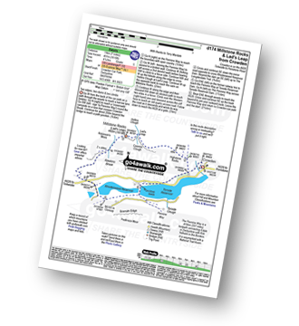
Route Summary:
Crowden - The Pennine Way - Highstone Rocks - Lad's Leap - Millstone Rocks (Lad's Leap) - Rhodeswood Reservoir - The Longdendale Trail - The Pennine Way - Torside Reservoir - Crowden
|
Vital Statistics:
| Length: | 12.5 miles (20 km) |
| Ascent: | 2,143ft (653m) |
| Time: | 6.75hrs |
| Grade: | |
Route Summary:
Hadfield - The Longdenden Trail - Tintwistle - Arnfield Gamekeepers Cottage - Arnfield Brook - Arnfield Farm - Tintwistle Low Moor - Ogden Brook - Arnfield Moor - Arnfield Flats - Ormes Moor - Wilderness - Windgate Edge - Blindstones Moor - Featherbed Moss (Chew Reservoir) - Laddow Moss - Black Chew Head (Laddow Rocks) - The Pennine Way - Oakenclough Brook - Rakes Rocks - Highstone Rocks - Torside Reservoir - Rhodeswood Reservoir - The Longdendale Trail - Hadfield
|
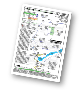
Vital Statistics:
| Length: | 10.5 miles (17 km) |
| Ascent: | 1,975ft (602m) |
| Time: | 5.75hrs |
| Grade: |  |
Route Summary:
Woodhead Tunnel - Middle Black Clough - Bleaklow Stones (Bleaklow Hill) - Bleaklow Head (Bleaklow Hill) - The Wain Stones (or Kissing Stones) - The Pennine Way - Clough Edge - The Longdendale Trail - Crowden - Woodhead Reservoir - Woodhead Tunnel
|
Vital Statistics:
| Length: | 5.25 miles (8.5 km) |
| Ascent: | 817ft (249m) |
| Time: | 2.75hrs |
| Grade: | |
Route Summary:
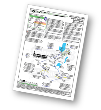
Winscar Reservoir - Dunford Bridge - The Barnsley Boundary Walk - Little Moor - The Trans Pennine Trail - The Longdendale Trail - Windle Edge - Upper Windleden Reservoir - Fiddlers Green - South Nab - Lady Cross - Salter's Brook Moss - Gallows Moss - Carr Top - Woodhead Railway Tunnel Air Shaft - Upper Grip Hill - Lower Grip Hill - Winscar Reservoir - Dunford Bridge.
|
Vital Statistics:
| Length: | 12 miles (19 km) |
| Ascent: | 1,365ft (416m) |
| Time: | 5.75hrs |
| Grade: | |
Route Summary:
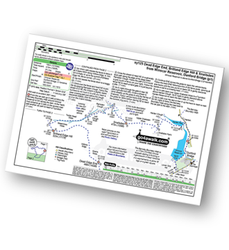
Winscar Reservoir - Dunford Bridge - The Barnsley Boundary Walk - Little Moor - The Trans Pennine Trail - The Longdendale Trail - Windle Edge - Bagshaw Ridge - Gallows Moss - Salter's Brook Moss - Long Side - Hawthorn Clough - Woodhead Railway Tunnel Air Shaft - Upper Head Dike - Dead Edge End - Upper Dead Edge - Grains Moss - Withins Edge - Britland Edge Hill - Bleakmires Moss - Twizle Head Moss - Lad Clough Knoll - Ramsden Clough - Snailsden - Upper Snailsden Moss - Harden Clugh - Harden Reservoir - Winscar Reservoir - Dunford Bridge.
|
Vital Statistics:
| Length: | 7.25 miles (11.5 km) |
| Ascent: | 896ft (273m) |
| Time: | 3.75hrs |
| Grade: | |
Route Summary:
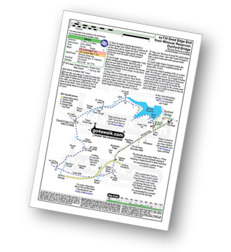
Winscar Reservoir - Dunford Bridge - The Barnsley Boundary Walk - Little Moor - The Trans Pennine Trail - The Longdendale Trail - Windle Edge - Bagshaw Ridge - Gallows Moss - Salter's Brook Moss - Long Side (Woodhead) - Hawthorn Clough - Woodhead Railway Tunnel Air Shaft - Upper Head Dike - Dead Edge End - Upper Dead Edge - Grains Moss - Little Grains Clough - Winscar Reservoir - Dunford Bridge.
See this list of walks, routes & maps in:
Grade Order | Length Order | Time Order | Walk Number or Start Location Order
NB. To reverse (toggle) this order, click Grade Order again
Not familiar with The Longdendale Trail?
See these 8 walks that include part of The Longdendale Trail on an interactive Google Map


