12 easy to follow walk route maps of all grades that include part of The Herriot Way
The Herriot Way is an 88km (55 miles) circular footpath starting and finishing in Aysgarth Falls in North Yorkshire, England.
The Herriot Way is waymarked by the occasional named post.
Not familiar with The Herriot Way?
See these 12 walks that include part of The Herriot Way on an interactive Google Map
See this list of walks, routes & maps in:
Grade Order | Length Order | Time Order | Walk Number or Start Location Order
NB. To reverse (toggle) this order, click Grade Order again
   |
Vital Statistics:
| Length: | 11 miles (17.5 km) |
| Ascent: | 2,681 ft (817 m) |
| Time: | 6.75 hrs |
| Grade: |  |

Route Summary:
Keld - The Pennine Way - The Herriot Way - The River Swale - Swaledale - Wainwright's Coast to Coast Walk - Kisdon Force - Crackpot Hall - Swinner Gill - Hind Hole Beck - Swinner Gill Lead Mines - East Grain - High Stone Man - Rogan's Seat - Moor Hen Nest - Water Crag (Arkengarthdale) - Blakethwaite Gill - Blakethwaite Meres - Blakethwaite Dams - Gunnerside Gill - Eweleap Scar - Bling Gill - Lownathwaite Mea - High Whim - Swinner Gill - Kisdon Force - Crackpot Hall - Keld
|
Vital Statistics:
| Length: | 12 miles (19 km) |
| Ascent: | 1,956 ft (596 m) |
| Time: | 6.25 hrs |
| Grade: |  |
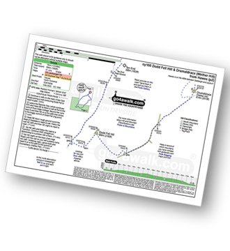
Route Summary:
Hawes - The Pennine Way - The Herriot Way - Gayle - Gaudy Lane - Rottonstone Hill - Ten End Peat Ground - West Cam Road - Dodd Fell Hill - North Gate - West Duerley Pasture - Cam High Road - Howgate Head - Drumaldrace (Wether Fell) - Wether Fell - Gayle - Hawes
|
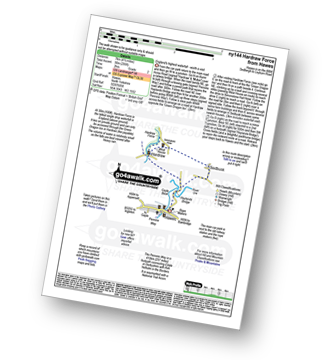
Vital Statistics:
| Length: | 8.5 miles (13.5 km) |
| Ascent: | 1,030 ft (314 m) |
| Time: | 4 hrs |
| Grade: |  |
Route Summary:
Hawes - The Pennine Way - The Herriot Way - Haylands Bridge - The River Ure - Hardraw - Hardraw Force - Shaw Gill Wood - Simonstone Hotel - High Shaw - Shivery Gill - Pike Hill - Abbotside Common - Low Clint - High Pasture Gate - Shutt Lane - Sedbusk - Hawes
|
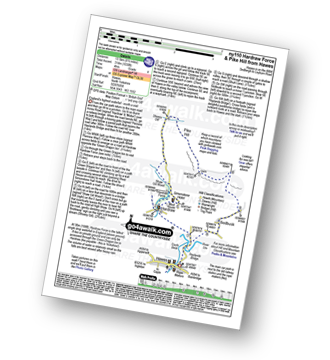
Vital Statistics:
| Length: | 8.75 miles (14 km) |
| Ascent: | 1,870 ft (570 m) |
| Time: | 5 hrs |
| Grade: | |
Route Summary:
Reeth - Arkle Beck - High Fremington - White House Farm - Fremington Edge - Fremington Edge Top - Fell End Lead Mine - Storthwaite Hall - Arkengarthdale - Langthwaite - Arken Town - Calver Hill - Riddings Farm - Skelgate Lane - Wainwright's Coast to Coast Walk - The Herriot Way - Reeth
|
Vital Statistics:
| Length: | 3.75 miles (6 km) |
| Ascent: | 295 ft (90 m) |
| Time: | 1.75 hrs |
| Grade: |  |
Route Summary:
Hawes - The Pennine Way - The Herriot Way - Haylands Bridge - The River Ure - Hardraw - Hardraw Force - West House - Simonstone Hotel - Sedbusk - Hawes
|
Vital Statistics:
| Length: | 11.25 miles (18 km) |
| Ascent: | 2,091 ft (637 m) |
| Time: | 6.25 hrs |
| Grade: | |

Route Summary:
Keld - The Pennine Way - The Herriot Way - Kisdon Force - Black Moor - Stonesdale Moor - The Tan Hill Inn - Tan Gill - Stonesdale Beck - Thomas Gill - Robert's Seat - Pryclose Gutter - Ravenseat - Wainwright's Coast to Coast Walk - Whitsundale Beck - How Edge Scars - Oven Mouth - Cotterby Scar - East Stonesdale Farm - The River Swale - Keld
|
Vital Statistics:
| Length: | 13.75 miles (22 km) |
| Ascent: | 2,330 ft (710 m) |
| Time: | 7.25 hrs |
| Grade: | |

Route Summary:
Hawes - The Pennine Way - The Herriot Way - Haylands Bridge - The River Ure - Hardraw - Hardraw Force - Hearne Coal Road - Hollin Hill - Bluebell Hill - Blea Pot Plain - Hearn Top - Bleak Haw - Hearne Head - Great Shunner Fell - Little Shunner Fell - Pickersett Mea - Fossdale Moss - Grimy Gutter - Lovely Seat - Coal Gill Hags - Abbotside Common - High Clint - High Pasture Gate - Shutt Lane - Sedbusk - Hawes
|
Vital Statistics:
| Length: | 12.75 miles (20.5 km) |
| Ascent: | 1,935 ft (590 m) |
| Time: | 6½ hrs |
| Grade: | |

Route Summary:
Reeth - River Swale - Harkerside Place Farm - Harker Mires - The Herriot Way - Low Harker Hill - High Harker Hill - Blue Hill - Beldow Hill - Green Hill Ends - Whitaside Moor - ashpot Gutters - Apedale Road (Track) Apedale - Dent's House - Greets Hill - How Hill - Grinton Lodge - The Herriot Way - Grinton - Arkle Beck - Reeth
|
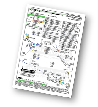
Vital Statistics:
| Length: | 9 miles (14.5 km) |
| Ascent: | 1,674 ft (510 m) |
| Time: | 5 hrs |
| Grade: |  |

Route Summary:
Reeth - Wainwright's Coast to Coast Walk - Arkle Beck - High Fremington - White House Farm - Fremington Edge - Fremington Edge Top - Fell End Lead Mine - Storthwaite Hall - Arkengarthdale - Langthwaite - Castle Farm House - Cuckoo Hill - The Herriot Way - Reeth
|
Vital Statistics:
| Length: | 3 miles (4.5 km) |
| Ascent: | 367 ft (112 m) |
| Time: | 1½ hrs |
| Grade: | |
Route Summary:
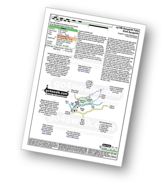
Aysgarth - Aysgarth Falls - High Force - The Herriot Way - Aysgarth Falls - Middle Force - Aysgarth Falls - Low Force - St Josephs Wood - Freeholders' Wood - Aysgarth
|
Vital Statistics:
| Length: | 7 miles (11 km) |
| Ascent: | 1,674 ft (411 m) |
| Time: | 4 hrs |
| Grade: | |

Route Summary:
Reeth - Wainwright's Coast to Coast Walk - Arkle Beck - High Fremington - White House Farm - Fremington Edge - Fremington Edge Top - Fell End Lead Mine - Storthwaite Hall - Arkengarthdale - Castle Farm House - Cuckoo Hill - The Herriot Way - Reeth
|
Vital Statistics:
| Length: | 7 miles (11 km) |
| Ascent: | 1,345 ft (410 m) |
| Time: | 3.75 hrs |
| Grade: | |

Route Summary:
Muker - Kisdon - Hooker Mill Scar - Swallow Hole Farm - Keld - The Herriot Way - The Pennine Way - The River Swale - Wainwright's Coast to Coast Walk - Kisdon Force - East Gill Force - Crackpot Hall - Swinner Gill - Arngill Wood - Swaledale - Ramps Holme Bridge - Muker
See this list of walks, routes & maps in:
Grade Order | Length Order | Time Order | Walk Number or Start Location Order
NB. To reverse (toggle) this order, click Grade Order again
Not familiar with The Herriot Way?
See these 12 walks that include part of The Herriot Way on an interactive Google Map


