4 easy to follow walk route maps of all grades that include part of The North Bucks Way
The North Bucks Way is a 56km (35 miles) linear footpath connecting Chequer's Knap, Great Kimble in Buckinghamshire, England with Wolverton in Buckinghamshire, England.
The North Bucks Way is waymarked by orange arrows.
Not familiar with The North Bucks Way?
See these 4 walks that include part of The North Bucks Way on an interactive Google Map
   |
Vital Statistics:
| Length: | 6.5 miles (10.5 km) |
| Ascent: | 230 ft (70 m) |
| Time: | 2½ hrs |
| Grade: |  |
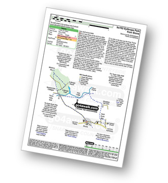
Route Summary:
Stone - Hartwell Church - Upper Hartwell - Whaddon Hill Farm - The North Bucks Way - River Thame - Thame Valley Walk - The Midshires Way - Weir Lodge - Bridge Lodge - Eythrope Park - Beachendon Cottages - Eythrope House - Aylesbury Ring - Stone
|
Vital Statistics:
| Length: | 4.5 miles (7 km) |
| Ascent: | 693 ft (211 m) |
| Time: | 2½ hrs |
| Grade: |  |

Route Summary:
Great Kimble - The North Bucks Way - Askett - Monks Risborough - Whiteleaf - The Icknield Way - The Ridgeway - Whiteleaf Cross - Cadsden - Grangelands And Pulpit Hill Nature Reserve - Chequer's Knap - The North Bucks Way - Great Kimble
|
Vital Statistics:
| Length: | 5.5 miles (9 km) |
| Ascent: | 853 ft (260 m) |
| Time: | 3 hrs |
| Grade: | |

Route Summary:
Butler's Cross - Monument Hill (Coombe Hill) - The Ridgeway - Linton's Wood - Goodmerhill Wood - Chisley Wood - The Icknield Way - Chequers - Pond Wood - Pulpit Wood - The North Bucks Way - The Midshires Way - Chequers Knap - Whorley Wood - Ellesborough Warren - Boxtree Wood - Beacon Hill (Ellesborough) - Ellesborough - The Aylesbury Ring - Springs Farm - Butler's Cross
|
Vital Statistics:
| Length: | 9 miles (14.5 km) |
| Ascent: | 328 ft (100 m) |
| Time: | 3½ hrs |
| Grade: | |
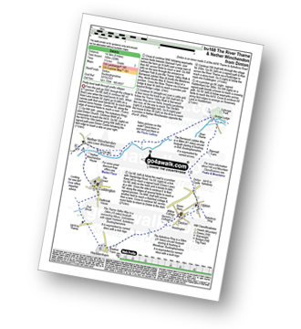
Route Summary:
Dinton - Upton - The Aylsebury Ring - Dinton Castle - Starveall Farm - Eythrope Park - The Midshires Way - The North Bucks Way - The Swans Way - Bridge Lodge - The River Thame - The Bernwood Jubilee Way - The Thame Valley Way - Nether Winchendon - Lower Winchendon - Cuddington - Haddenham - Dad Brook - Townsend - Haddenham - Westington - Dinton
Not familiar with The North Bucks Way?
See these 4 walks that include part of The North Bucks Way on an interactive Google Map


