12 easy to follow walk route maps of all grades that include part of The Manifold Way
The Manifold Way is a 13km (8 miles) linear footpath connecting Hulme End in Staffordshire, England with Waterhouses in Staffordshire, England.
Originally a 2ft 6in (0.762m) gauge light railway for tourists the line was opened in 1904. Never a great success it was finally closed in 1934 and became a bridleway three years later.
The Manifold Way is waymarked by named posts.
Not familiar with The Manifold Way?
See these 12 walks that include part of The Manifold Way on an interactive Google Map
See this list of walks, routes & maps in:
Grade Order | Length Order | Time Order | Walk Number or Start Location Order
NB. To reverse (toggle) this order, click Grade Order again
   |
Vital Statistics:
| Length: | 8.25 miles (13 km) |
| Ascent: | 1,588 ft (484 m) |
| Time: | 4½ hrs |
| Grade: |  |

Route Summary:
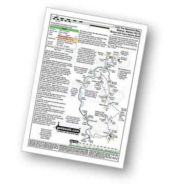
Waterhouses - The Manifold Way - The River Hamps - Sparrowlee Bridge - Lee House - Hell Hole - Old Soles Wood - Soles Coppice - The River Manifold - Weag's Bridge - Beeston Tor Farm - Throwley Hall Farm - Throwley Cottage - Farwall Farm - The Manifold Way - Waterhouses
|
Vital Statistics:
| Length: | 8.75 miles (14 km) |
| Ascent: | 1,848 ft (563 m) |
| Time: | 5 hrs |
| Grade: |  |
Route Summary:
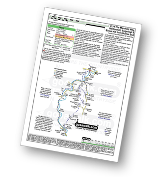
Hulme End - Manifold Valley Visitors Centre - The Manifold Way - Dale Bridge - The Lee - Tunnel - River Manifold - Wetton Mill Farm - Wettonmill - Dafar Bridge - Ladyside Wood - Wetton - Wetton Hill (South West Top) - Wetton Hill - Cantrell's House - Ecton Hill - Westside Mill - The Manifold Way - Hulme End
|
Vital Statistics:
| Length: | 3.75 miles (6 km) |
| Ascent: | 289 ft (88 m) |
| Time: | 1.75 hrs |
| Grade: |  |

Route Summary:
Hulme End - Manifold Valley Visitors Centre - Lowend - Low End Farm - Buttsend - Brund - The Manifold Way - The River Manifold - Brund Mill - Holme House - Hulme End
|
Vital Statistics:
| Length: | 6 miles (9.5 km) |
| Ascent: | 1,034 ft (315 m) |
| Time: | 3.25 hrs |
| Grade: |  |
Route Summary:
Hulme End - Manifold Valley Visitors Centre - The Manifold Way - Dale Bridge - The Lee - Tunnel - River Manifold - Wetton Mill Farm - Wettonmill - Dale Farm - Sugarloaf (Wetton) - Broad Ecton Farm - Ecton Hill - Westside Mill - The Manifold Way - Hulme End
|
Vital Statistics:
| Length: | 4.5 miles (7 km) |
| Ascent: | 623 ft (190 m) |
| Time: | 2.25 hrs |
| Grade: | |

Route Summary:
Wetton - River Manifold - Wettonmill - The Manifold Way - Thor's Cave - Manor House - Wetton
|
Vital Statistics:
| Length: | 6.5 miles (10.5 km) |
| Ascent: | 689 ft (210 m) |
| Time: | 3.25 hrs |
| Grade: | |
Route Summary:
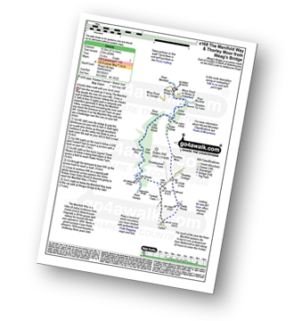
Weag's Bridge - River Manifold - The Manifold Way - River Hamps - Lee House Farm - Farwell Farm - Calton - Slade House - Throwley Moor - Soles Hollow - The Manifold Way - River Manifold - Weag's Bridge
|
Vital Statistics:
| Length: | 4.75 miles (7.5 km) |
| Ascent: | 909 ft (277 m) |
| Time: | 3 hrs |
| Grade: | |

Route Summary:
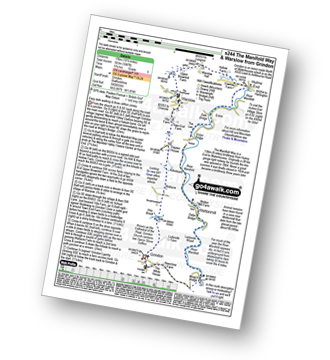
Grindon - Weag's Bridge - The Manifold Way - Thor's Cave - Wettonmill - Hoo Brook - Grindon
|
Vital Statistics:
| Length: | 8.75 miles (14 km) |
| Ascent: | 1,690 ft (515 m) |
| Time: | 5 hrs |
| Grade: | |
Route Summary:
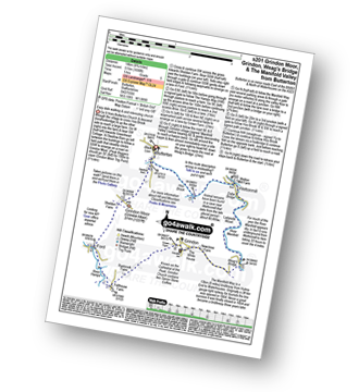
Butterton - Grindon Moor (Grindon Moor) - Ford - Ryebrook Farm - Grindon - Weag's Bridge - The Manifold Way - The River Manifold - Thor's Cave - Ladyside Wood - Dafar Bridge - Wettonmill - Hoo Brook - Butterton
|
Vital Statistics:
| Length: | 11.5 miles (18 km) |
| Ascent: | 1,267 ft (386 m) |
| Time: | 5½ hrs |
| Grade: | |

Route Summary:
Waterhouses - Waterfall Cross - Martins Low - River Hamps - Ford - Onecote - Grindonmoor Gate - Grindon Moor (Grindon Moor) - Grindon - Lee House - The Manifold Way - Waterhouses
|
Vital Statistics:
| Length: | 10.25 miles (16.5 km) |
| Ascent: | 1,486 ft (453 m) |
| Time: | 5.25 hrs |
| Grade: | |

Route Summary:
Ilam - The Manifold Trail - Ilam Country Park - River Manifold - Castern Hall - Castern Wood Nature Reserve - Weag's Bridge - The Manifold Way - The River Hamps - Manifold Valley - Lee House Farm - Throwley Moor - Slade House - Rushley - Ilam Country Park - Ilam
|
Vital Statistics:
| Length: | 10.5 miles (17 km) |
| Ascent: | 1,847 ft (563 m) |
| Time: | 5.75 hrs |
| Grade: | |
Route Summary:
Grindon - Weag's Bridge - The Manifold Way - The River Manifold - Thor's Cave - Dafar Bridge - Wettonmill - Ecton Bridge - Dale Bridge - Ecton - Hulme End - Hollow Farm - Warslow Hall - Upper Brownhill Farm - Warslow - Villa Farm - Clayton House - Wallacre - Hoo Brook - Ladyside Farm - Grindon
|
Vital Statistics:
| Length: | 7 miles (10.5 km) |
| Ascent: | 787 ft (240 m) |
| Time: | 3.25 hrs |
| Grade: |  |

Route Summary:
Wettonmill - Hoo Brook - Butterton - Warslow - Dale Bridge - Ecton - The Manifold Way - The River Manifold - Manifold Valley - Wettonmill
See this list of walks, routes & maps in:
Grade Order | Length Order | Time Order | Walk Number or Start Location Order
NB. To reverse (toggle) this order, click Grade Order again
Not familiar with The Manifold Way?
See these 12 walks that include part of The Manifold Way on an interactive Google Map


