3 easy to follow walk route maps of all grades that include part of The Marches Way
The Marches Way is a 329km (204 miles) linear footpath connecting Chester in Cheshire, England with Cardiff in Cardiff, England.
The Marches Way is waymarked by named posts.
Not familiar with The Marches Way?
See these 3 walks that include part of The Marches Way on an interactive Google Map
   |
Vital Statistics:
| Length: | 7.75 miles (12.5 km) |
| Ascent: | 1,083ft (330m) |
| Time: | 4 hrs |
| Grade: |  |
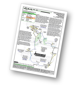
Route Summary:
Pontesbury - Oaks Wood - The Marches Way - Oaks - Wrentnall - Pulverbatch - Habberley - Pontesbury
|
Vital Statistics:
| Length: | 9 miles (14.5 km) |
| Ascent: | 797ft (243m) |
| Time: | 4.25hrs |
| Grade: | |
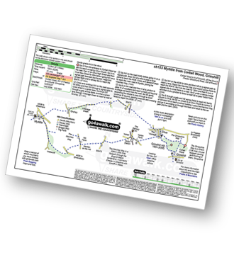
Route Summary:
Corbet Wood - Grinshill - Clive - Grumpy - Myddle - The Marches Way - Webscott - Newton on the Hill - Yorton - Clive - Grinshill - The Shropshire Way - Corbet Wood - Grinshill
|
Vital Statistics:
| Length: | 6 miles (9.5 km) |
| Ascent: | 351ft (107m) |
| Time: | 2½ hrs |
| Grade: |  |
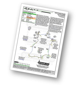
Route Summary:
Grinshill - The Marches Way - Yorton Villa Farm - Yorton House Farm - Yorton Heath - Sansaw Heath - Sheepcotes - Sansaw Business Park - The Shropshire Way - Grinshill
Not familiar with The Marches Way?
See these 3 walks that include part of The Marches Way on an interactive Google Map


