14 easy to follow walk route maps of all grades that include part of The St Cuthbert's Way
Fourteen easy-to-follow walk route maps of all grades that include part of The St Cuthbert's Way in Walk Start Location Order (Z to A)
The St Cuthbert's Way is a 100km (62 miles) linear footpath connecting Melrose Abbey in The Borders, Scotland with Holy Island (Lindisfarne) in Northumberland, England.
The St Cuthbert's Way is waymarked by a Celtic Cross.
Tap/mouse over a coloured circle (1-3 easy walks, 4-6 moderate walks, 7-9 hard walks) and click to select.
You can use these checkboxes to show only the grades of walk you are interested in:-
See this list of walks, routes & maps in:
Grade Order |
Length Order |
Time Order |
Walk Number or Start Location Order
NB. To reverse (toggle) this order, click Start Order again
Scroll down the list of walks below & click on each walk title (in blue) to locate it on the map above.
   |
Vital Statistics:
| Length: | 6.5 miles (10.5 km) |
| Ascent: | 1,043ft (318m) |
| Time: | 3½ hrs |
| Grade: |  |
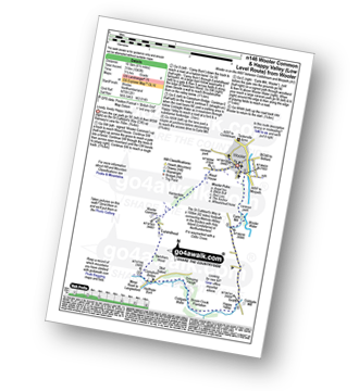
Route Summary:
Wooler - The St Cuthbert's Way - Waud House - Kenterdale Hill - Wooler Common - Switcher Wood - Earlhillhead Farm - Carey Burn - Careyburn Bridge - Harthope Burn - Colgate Water (Low Level Route) - Skirl Naked - Grimping Haugh - Broom Crook Plantation - Happy Valley - Careyburn Bridge - Colgate Mill - Earle Mill - Wooler Water - Wooler
|
Vital Statistics:
| Length: | 7.5 miles (12 km) |
| Ascent: | 1,257ft (383m) |
| Time: | 4½ hrs |
| Grade: |  |
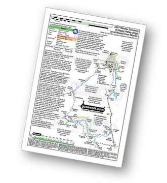
Route Summary:
Wooler - The St Cuthbert's Way - Waud House - Kenterdale Hill - Wooler Common - Switcher Wood - Earlhillhead Farm - Carey Burn - Careyburn Bridge - Harthope Burn - Colgate Water (High Level Route) - Happy Valley - Middleton Old Town - North Middleton - Colgate Mill - Colgate Water - Earle Mill - Wooler Water - Wooler
|
Vital Statistics:
| Length: | 10.75 miles (17 km) |
| Ascent: | 1,746ft (532m) |
| Time: | 5.75hrs |
| Grade: |  |
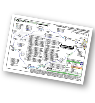
Route Summary:
Wooler - The St Cuthbert's Way - Waud House - Kenterdale Hill - Wooler Common - Carey Burn - Broadstruthers Burn - Commonburn House - Wackerage Cairn - Tom Tallon's Crag - The St Cuthbert's Way - Gleadscleugh - Akeld Burn - Humbleton - Gallowlaw - Wooler
|
Vital Statistics:
| Length: | 3.25 miles (5 km) |
| Ascent: | 525ft (160m) |
| Time: | 1.75hrs |
| Grade: |  |
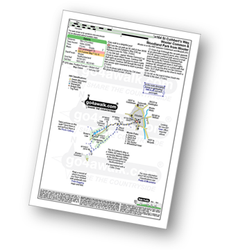
Route Summary:
Wooler - The St Cuthbert's Way - Waud House - Kenterdale Hill - Wooler Common and Woodland Park - Wooler
|
Vital Statistics:
| Length: | 8.5 miles (13.5 km) |
| Ascent: | 1,093ft (333m) |
| Time: | 4.25hrs |
| Grade: | |
Route Summary:
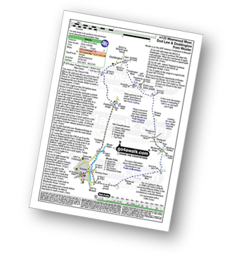
Wooler - The St Cuthbert's Way - Weetwood Bank - Weetwood Moor - River Till - Weetwood Bridge - Weetwood Hall - Weetwood Hill - Broomy Knowe - Shepherds House - Dod Law - Doddington Moor - Doddington - Milfield Plain - Doddington Bridge - Turvelaws Farm - Wooler
|
Vital Statistics:
| Length: | 10.25 miles (16.5 km) |
| Ascent: | 1,182ft (360m) |
| Time: | 5 hrs |
| Grade: | |
Route Summary:
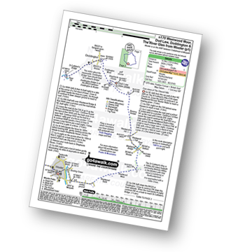
Wooler - The St Cuthbert's Way - Weetwood Bank - Weetwood Moor - River Till - Weetwood Bridge - Weetwood Hall - Weetwood Hill - Broomy Knowe - Shepherds House - Dod Law (Doddington Moor) - Doddington Moor - Doddington - River Till - St Cuthbert's Bridge - Milfield Plain - River Glen - Bridge End - Bowchester - Low Humbleton - Gallowlaw Hill - Gallowlaw - Wooler
|
Vital Statistics:
| Length: | 5.75 miles (9 km) |
| Ascent: | 1,214ft (370m) |
| Time: | 3½ hrs |
| Grade: | |
Route Summary:
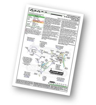
Wooler - Gallowlaw Gallowlaw Hill - Humbleton - Humbleton Hill - Brown's Law - Wooler Common and Woodland Park - The St Cuthbert's Way - Kenterdale Hill - Waud House - Wooler
|
Vital Statistics:
| Length: | 8.75 miles (14 km) |
| Ascent: | 1,260ft (384m) |
| Time: | 4½ hrs |
| Grade: | |
Route Summary:
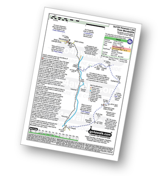
Morebattle - The St Cuthbert's Way - Kale Water - Grubbit Law - Cushat End - Hownam Law - South Cote - Howgate - Heavyside - Gateshaw - Morebattle
|
Vital Statistics:
| Length: | 5 miles (8 km) |
| Ascent: | 180ft (55m) |
| Time: | 2 hrs |
| Grade: |  |
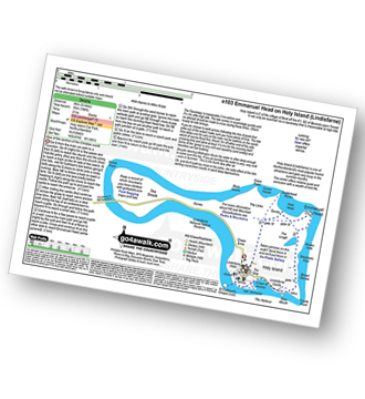
Route Summary:
Holy Island (Lindisfarne) Car Park - The Priory - The St Cuthbert's Way - Lindisfarne Castle - Emannuel Head - Holy Island (Lindisfarne) Car Park
|
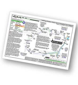
Vital Statistics:
| Length: | 7.5 miles (12 km) |
| Ascent: | 1,316ft (401m) |
| Time: | 4 hrs |
| Grade: | |
Route Summary:
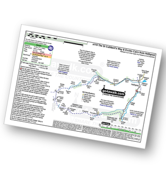
Hethpool - The St Cuthbert's Way - White Hill (Hethpool) - East Laddie's Knowe - Laddie's Knowe or Betsy's Cairn - Black Bog (Haddon Hill) - Haddon Hill - Ring Chesters - Sheepfold - Eccles Cairn - England / Scotland Border - Elsdonnurn Farm - Elsdon Burn - The St Cuthbert's Way - Hethpool
|
Vital Statistics:
| Length: | 5 miles (8 km) |
| Ascent: | 1,021ft (311m) |
| Time: | 3 hrs |
| Grade: |  |
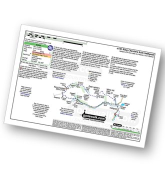
Route Summary:
Hethpool - The St Cuthbert's Way - White Hill (Hethpool) - East Laddie's Knowe - Laddie's Knowe or Betsy's Cairn - Black Bog (Haddon Hill) - Haddon Hill - Ring Chesters - Elsdonburn Farm - Elsdon Burn - The St Cuthbert's Way - Hethpool
|
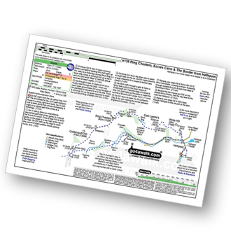
Vital Statistics:
| Length: | 8.25 miles (13 km) |
| Ascent: | 1,483ft (452m) |
| Time: | 4½ hrs |
| Grade: | |
Route Summary:
Hethpool - The St Cuthbert's Way - White Hill (Hethpool) - East Laddie's Knowe - Laddie's Knowe or Betsy's Cairn - Black Bog (Haddon Hill) - Haddon Hill - Ring Chesters - Sheepfold - Eccles Cairn - England / Scotland Border - The Pennine Way - Tuppie's Grave - The Tongue - Maddie's Well - Madam Law - Wideopen Head - Trowup Burn - Trowupburn - College Valley - College Burn - Hethpool
|
Vital Statistics:
| Length: | 13.75 miles (22 km) |
| Ascent: | 2,665ft (812m) |
| Time: | 7.75hrs |
| Grade: |  |
Route Summary:
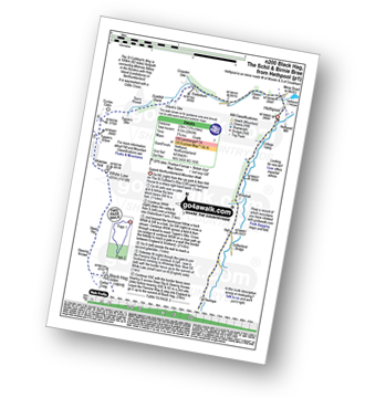
Hethpool - The St Cuthbert's Way - Elsdon Burn - Elsdonburn Farm - Shank's Sike - Scaldhill Shank - Tom's Knowe - Tuppie's Sike - Eccles Cairn - England / Scotland Border - The Pennine Way - White Law - Steel Rig - Black Hag (Hethpool) - The Schil - Birnie Brae - Red Cribs - Mounthooly - Fleehope - Whitehall - College Valley - Hethpool
|
Vital Statistics:
| Length: | 7.25 miles (11.5 km) |
| Ascent: | 1,165ft (355m) |
| Time: | 3.75hrs |
| Grade: | |
Route Summary:
Hethpool - The St Cuthbert's Way - Elsdon Burn - Elsdonburn Farm - Shank's Sike - Scaldhill Shank - Tom's Knowe - Tuppie's Sike - Eccles Cairn - England / Scotland Border - The Pennine Way - Tuppie's Grave - The Tongue - Maddie's Well - Madam Law - Wideopen Head - Trowup Burn - Trowupburn - College Valley - College Burn - Hethpool
See this list of walks, routes & maps in:
Grade Order |
Length Order |
Time Order |
Walk Number or Start Location Order
NB. To reverse (toggle) this order, click Start Order again


