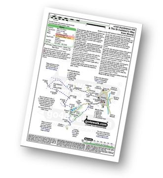
Nine easy to follow circular walk route maps from the busy town of Wooler in the Northumberland National Park, Northumberland, England
   |
Vital Statistics:
| Length: | 6.5 miles (10.5 km) |
| Ascent: | 240ft (73m) |
| Time: | 2.75hrs |
| Grade: |  |
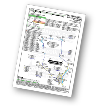
Route Summary:
Wooler - Gallowlaw Gallowlaw Hill - Low Humbleton - Bowchester - The River Glen - Bridge End - Humbleton Burn Milfield Plain - St Cuthbert's Bridge - Turvelaws Farm - Wooler
|
Vital Statistics:
| Length: | 3.25 miles (5 km) |
| Ascent: | 525ft (160m) |
| Time: | 1.75hrs |
| Grade: | |
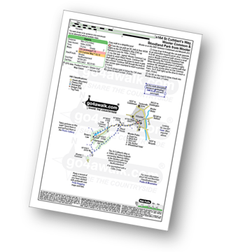
Route Summary:
Wooler - The St Cuthbert's Way - Waud House - Kenterdale Hill - Wooler Common and Woodland Park - Wooler
|
Vital Statistics:
| Length: | 4.75 miles (7.5 km) |
| Ascent: | 985ft (300m) |
| Time: | 2.75hrs |
| Grade: |  |
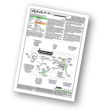
Route Summary:
Wooler - Gallowlaw Gallowlaw Hill - Humbleton - Humbleton Hill - Brown's Law - Wooler Common And Woodland Park - Wooler
|
Vital Statistics:
| Length: | 8.5 miles (13.5 km) |
| Ascent: | 1,093ft (333m) |
| Time: | 4.25hrs |
| Grade: |  |
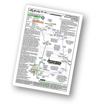
Route Summary:
Wooler - The St Cuthbert's Way - Weetwood Bank - Weetwood Moor - River Till - Weetwood Bridge - Weetwood Hall - Weetwood Hill - Broomy Knowe - Shepherds House - Dod Law - Doddington Moor - Doddington - Milfield Plain - Doddington Bridge - Turvelaws Farm - Wooler
|
Vital Statistics:
| Length: | 5.75 miles (9 km) |
| Ascent: | 1,214ft (370m) |
| Time: | 3½ hrs |
| Grade: | |
Route Summary:
Wooler - Gallowlaw Gallowlaw Hill - Humbleton - Humbleton Hill - Brown's Law - Wooler Common and Woodland Park - The St Cuthbert's Way - Kenterdale Hill - Waud House - Wooler
|
Vital Statistics:
| Length: | 6.5 miles (10.5 km) |
| Ascent: | 1,043ft (318m) |
| Time: | 3½ hrs |
| Grade: | |
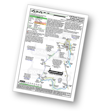
Route Summary:
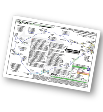
Wooler - The St Cuthbert's Way - Waud House - Kenterdale Hill - Wooler Common - Switcher Wood - Earlhillhead Farm - Carey Burn - Careyburn Bridge - Harthope Burn - Colgate Water (Low Level Route) - Skirl Naked - Grimping Haugh - Broom Crook Plantation - Happy Valley - Careyburn Bridge - Colgate Mill - Earle Mill - Wooler Water - Wooler
|
Vital Statistics:
| Length: | 7.5 miles (12 km) |
| Ascent: | 1,257ft (383m) |
| Time: | 4½ hrs |
| Grade: |  |
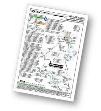
Route Summary:
Wooler - The St Cuthbert's Way - Waud House - Kenterdale Hill - Wooler Common - Switcher Wood - Earlhillhead Farm - Carey Burn - Careyburn Bridge - Harthope Burn - Colgate Water (High Level Route) - Happy Valley - Middleton Old Town - North Middleton - Colgate Mill - Colgate Water - Earle Mill - Wooler Water - Wooler
|
Vital Statistics:
| Length: | 10.25 miles (16.5 km) |
| Ascent: | 1,182ft (360m) |
| Time: | 5 hrs |
| Grade: | |
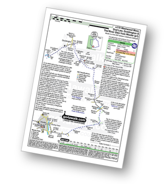
Route Summary:
Wooler - The St Cuthbert's Way - Weetwood Bank - Weetwood Moor - River Till - Weetwood Bridge - Weetwood Hall - Weetwood Hill - Broomy Knowe - Shepherds House - Dod Law (Doddington Moor) - Doddington Moor - Doddington - River Till - St Cuthbert's Bridge - Milfield Plain - River Glen - Bridge End - Bowchester - Low Humbleton - Gallowlaw Hill - Gallowlaw - Wooler
|
Vital Statistics:
| Length: | 10.75 miles (17 km) |
| Ascent: | 1,746ft (532m) |
| Time: | 5.75hrs |
| Grade: |  |
Route Summary:
Wooler - The St Cuthbert's Way - Waud House - Kenterdale Hill - Wooler Common - Carey Burn - Broadstruthers Burn - Commonburn House - Wackerage Cairn - Tom Tallon's Crag - The St Cuthbert's Way - Gleadscleugh - Akeld Burn - Humbleton - Gallowlaw - Wooler


