17 easy to follow walk route maps of all grades that include part of The South Downs Way
Seventeen easy-to-follow walk route maps of all grades that include part of The South Downs Way in Walk Grade Order
The South Downs Way is a 162km (101 miles) linear footpath connecting Eastbourne (Holywell) in East Sussex, England with Winchester in Hampshire, England.
The South Downs Way is waymarked by a National Trail acorn.
Tap/mouse over a coloured circle (1-3 easy walks, 4-6 moderate walks, 7-9 hard walks) and click to select.
You can use these checkboxes to show only the grades of walk you are interested in:-
See this list of walks, routes & maps in:
Grade Order |
Length Order |
Time Order |
Walk Number or Start Location Order
NB. To reverse (toggle) this order, click Grade Order again
Scroll down the list of walks below & click on each walk title (in blue) to locate it on the map above.
   |
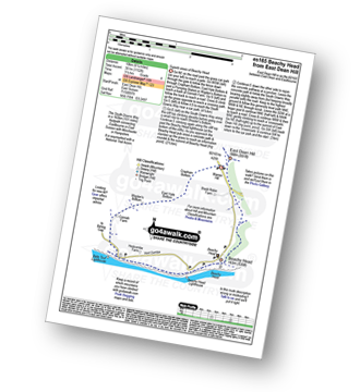
Vital Statistics:
| Length: | 8.25 miles (13 km) |
| Ascent: | 1,594ft (486m) |
| Time: | 4½ hrs |
| Grade: |  |
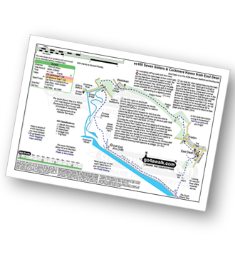
Route Summary:
East Dean - The South Downs Way - The Seven Sisters - Went Hill - Michel Dean - Bailey's Hill - Flathill Bottom - Flat Hill - Flagstaff Bottom - Flagstaff Brow - Gap Bottom - Brass Point - Rough Bottom - Rough Brow - Limekiln Bottom - Short Brow - Short Bottom - Haven Brow - Cliff End - Exceat - Westdean - Begger's Croft - Friston Forest - Middle Brow - Friston Hill - Friston Place - East Dean
|
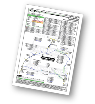
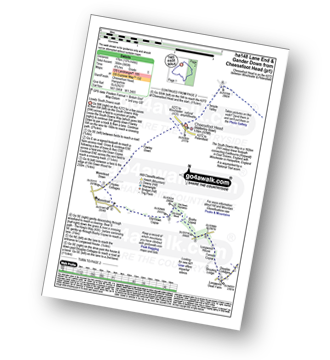
Vital Statistics:
| Length: | 7.25 miles (11.5 km) |
| Ascent: | 1,109ft (338m) |
| Time: | 3.75hrs |
| Grade: |  |
Route Summary:
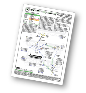
Wilmington - The Wealdway - The Long Man of Wilmington - The South Downs Way - Lullington Church - Litlington - Litlington Heath - Jevington Holt - Wilmington Hill - The Wealdway - The Holt - Wilmington
|
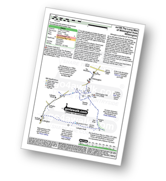
Vital Statistics:
| Length: | 8.5 miles (13.5 km) |
| Ascent: | 1,388ft (423m) |
| Time: | 4½ hrs |
| Grade: | |
Route Summary:
Wilmington - The Wealdway - The Long Man of Wilmington - The South Downs Way - Lullington Church - Litlington - Litlington Heath - Jevington - The Wealdway - Cranedown Bottom - Folkington - The Holt - Wilmington
|
Vital Statistics:
| Length: | 14.5 miles (23 km) |
| Ascent: | 3,177ft (968m) |
| Time: | 8½ hrs |
| Grade: |  |
Route Summary:
East Dean - Ringwood Bottom - East Dean Hill - The South Downs Way - Beachy Head - Belle Tout - Birling Gap - The Seven Sisters - Went Hill - Michel Dean - Bailey's Hill - Flathill Bottom - Flat Hill - Flagstaff Bottom - Flagstaff Brow - Gap Bottom - Brass Point - Rough Bottom - Rough Brow - Limekiln Bottom - Short Brow - Short Bottom - Haven Brow - Cliff End - Exceat - Westdean - Begger's Croft - Friston Forest - Middle Brow - Friston Hill - Friston Place - East Dean
|
Vital Statistics:
| Length: | 6.75 miles (10.5 km) |
| Ascent: | 952ft (290m) |
| Time: | 3.25hrs |
| Grade: | |
Route Summary:
Jevington - The Wealdway - Cranedown Bottom - Folkington - The Holt - The Long Man of Wilmington - The South Downs Way - Wilmington Hill - Tenantry Ground - Jevington Holt - Jevington
|
Vital Statistics:
| Length: | 9.75 miles (15.5 km) |
| Ascent: | 1,122ft (342m) |
| Time: | 4.75hrs |
| Grade: | |
Route Summary:
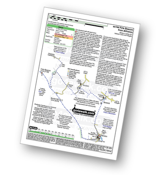
Alfriston - The South Downs Way - Bostal Hill - Firle Beacon - Tilton Farm - Charleston Farmhouse - Upper Barn - Bopeep Farm - Alciston - Berwick - The Vanguard Way - Alfriston
|
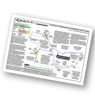
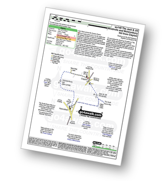
Vital Statistics:
| Length: | 5.5 miles (9 km) |
| Ascent: | 804ft (245m) |
| Time: | 2.75hrs |
| Grade: |  |
Route Summary:
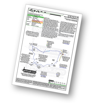
Ditchling Beacon Car Park - Ditchling Beacon - Heathy Brpw - Borth Bottom - Lower Standean Farm - New Barn Farm - Clayton Windmills - Jill Windmill - Jack Windmill - The South Downs Way - Ditchling Beacon.
|
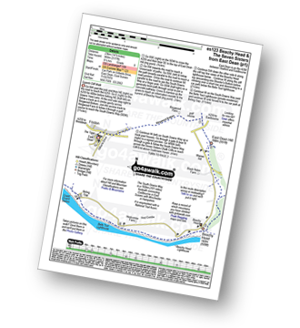
Vital Statistics:
| Length: | 8.5 miles (13.5 km) |
| Ascent: | 2,045ft (623m) |
| Time: | 5.25hrs |
| Grade: |  |
Route Summary:
East Dean - Ringwood Bottom - East Dean Hill - The South Downs Way - Beachy Head - Belle Tout - Birling Gap - Went Hill - East Dean
|
Vital Statistics:
| Length: | 6.25 miles (10 km) |
| Ascent: | 1,152ft (351m) |
| Time: | 3½ hrs |
| Grade: | |
Route Summary:
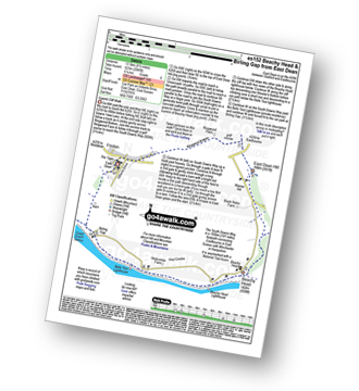
East Dean Hill Car Park - East Dean Hill - The South Downs Way - Beachy Head - Belle Tout - Hod Combe - Birling Gap - Wigden's Bottom - East Hale Bottom - Crapham Bottom - East Dean Hill.
|
Vital Statistics:
| Length: | 9.75 miles (15.5 km) |
| Ascent: | 1,126ft (343m) |
| Time: | 4.75hrs |
| Grade: | |
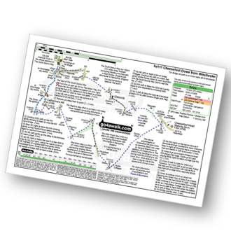
Route Summary:
Winchester - Tun Bridge - The Itchen Way - Itchen Navigation - St Catherine's Hill - Pilgrims' Trail - Twyford Down - Morestead Down - Hydes Cottages - Fawley Down - The Allan King's Way - Cheesefoot Head Car Park - Cheesefoot Head (Matterley Bowl) - The South Downs Way - The Pilgrim's Way - Telegraph Hill - Little Golders - Chilcomb - Highcliffe - The Soke - City Mill - Wharf Bridge - Tun Bridge - Winchester
|
Vital Statistics:
| Length: | 10 miles (16 km) |
| Ascent: | 985ft (300m) |
| Time: | 4.75hrs |
| Grade: | |
Route Summary:
Cheesefoot Head Car Park - Cheesefoot Head (Matterley Bowl) - Fawley Down - Hydes Cottages - Morestead - Old Down Copse - Bushy Copse - Longwood House - Longwood Dead Farm - Lane End - The South Downs Way - Holden Farm - Gander Down - Temple Valley - Cheesefoot Head Car Park
|
Vital Statistics:
| Length: | 9 miles (14.5 km) |
| Ascent: | 1,594ft (486m) |
| Time: | 5 hrs |
| Grade: | |
Route Summary:
Clayton - Clayton Windmills - Jill Windmill - Jack Windmill - The South Downs Way - Ditchling Beacon - Heathy Brow - North Bottom - Lower Standean Farm - New Barn Farm - The South Downs Way - Haresdean - Wolstonbury Hill - Clayton
|
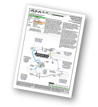
Vital Statistics:
| Length: | 5.5 miles (9 km) |
| Ascent: | 630ft (192m) |
| Time: | 2½ hrs |
| Grade: | |
Route Summary:
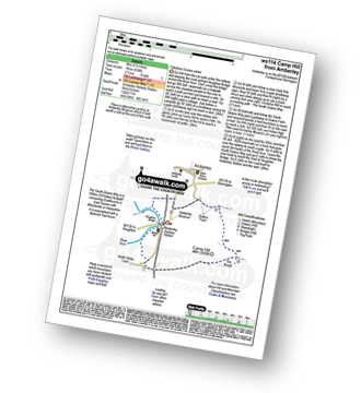
Amberley Museum - Amberley Railway Station - Houghton Bridge - The River Arun - North Stoke - Camp Hill - The South Downs Way - High Titten - Foxleigh Down - The River Arun - Amberley.
|
Vital Statistics:
| Length: | 3.75 miles (6 km) |
| Ascent: | 689ft (210m) |
| Time: | 2.25hrs |
| Grade: | |
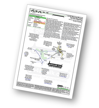
Route Summary:
Steyning - Spring Meadows Farm - The South Downs Way - Steyning Round Hill - The Monarch's Way - Pepperscoombe Farm - Steyning
|
Vital Statistics:
| Length: | 4.5 miles (7 km) |
| Ascent: | 754ft (230m) |
| Time: | 2½ hrs |
| Grade: | |
Route Summary:
Clayton - Clayton Windmills - Jill Windmill - Jack Windmill - The South Downs Way - New Barn Farm - Haresdean - Wolstonbury Hill - Clayton
|
Vital Statistics:
| Length: | 6.25 miles (10 km) |
| Ascent: | 660ft (201m) |
| Time: | 3 hrs |
| Grade: | |
Route Summary:
Amberley Museum - Amberley Railway Station - Houghton Bridge - The River Arun - North Stoke - Camp Hill - The South Downs Way - Amberley Village - Amberley Castle - The River Arun - Amberley.
|
Vital Statistics:
| Length: | 7.75 miles (12.5 km) |
| Ascent: | 932ft (284m) |
| Time: | 3.75hrs |
| Grade: | |
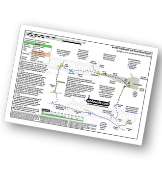
Route Summary:
Storrington - Greyfriars Farm - Chantry Hill - Kithurst Hill - The South Downs Way - Springhead Hill - Rackham Hill - Rackham - Parham House - Cootham - Storrington
See this list of walks, routes & maps in:
Grade Order |
Length Order |
Time Order |
Walk Number or Start Location Order
NB. To reverse (toggle) this order, click Grade Order again


