24 easy to follow walk route maps of all grades that include part of The Dales Way
The Dales Way is a 130km (81 miles) linear footpath connecting Ilkley in West Yorkshire, England with Bowness-On-Windermere in Cumbria, England.
The Dales Way is waymarked by named posts.
Not familiar with The Dales Way?
See these 24 walks that include part of The Dales Way on an interactive Google Map
See this list of walks, routes & maps in:
Grade Order |
Length Order |
Time Order |
Walk Number or Start Location Order
NB. To reverse (toggle) this order, click Length Order again
   |
Vital Statistics:
| Length: | 4.75 miles (7.5 km) |
| Ascent: | 880ft (268m) |
| Time: | 2.75hrs |
| Grade: |  |
Route Summary:
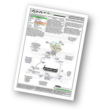
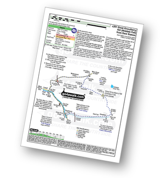
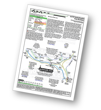
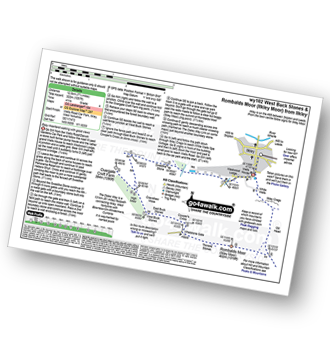
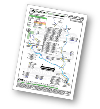
Ilkley - The Dales Way - Grainings Head - Cowper's Cross - Whetstone Gate - Rombalds Moor (Ilkley Moor) - The Dales Way Link - Gill Head - Ilkley Crags - White Wells - Ilkley
|
Vital Statistics:
| Length: | 5.5 miles (8.5 km) |
| Ascent: | 974ft (297m) |
| Time: | 3 hrs |
| Grade: |  |
Route Summary:
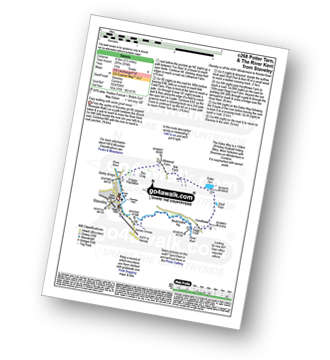
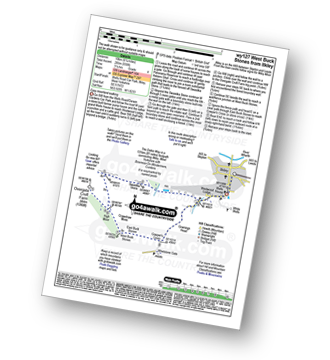
Staveley - Barley Bridge - Craggy Plantation - Spy Crag - Littlewood Farm - Birk Field Farm - Potter Tarn - Ghyll Pool - Hundhowe - Hagg Foot - The River Kent - The Dales Way - Beckmickle Ing - Staveley
|
Vital Statistics:
| Length: | 5.5 miles (8.5 km) |
| Ascent: | 1,004ft (306m) |
| Time: | 3 hrs |
| Grade: | |
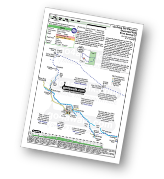
Route Summary:
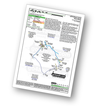
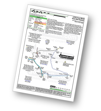
Dent - Flinter Gill - Green Lane - Nun House Outrake - The Dales Way - River Dee - Dent
|
Vital Statistics:
| Length: | 6 miles (9.5 km) |
| Ascent: | 531ft (246m) |
| Time: | 2½ hrs |
| Grade: | |
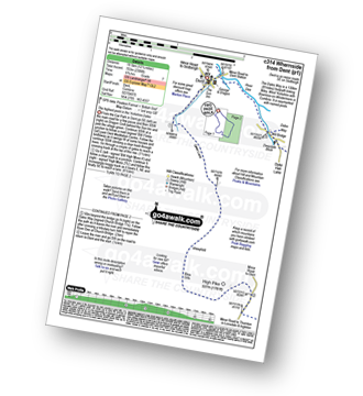
Route Summary:
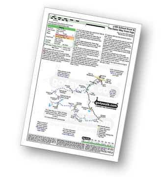
Ings - High Fairbank - The Dales Way - Crag House Farm - Outrun Nook - Hag End Farm - School Knott - Schoolknott Plantation - Whasdike Farm - Ings
|
Vital Statistics:
| Length: | 6.25 miles (10 km) |
| Ascent: | 1,548ft (472m) |
| Time: | 4 hrs |
| Grade: |  |
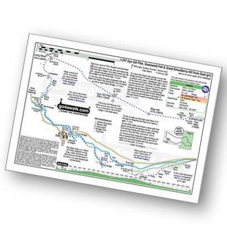
Route Summary:
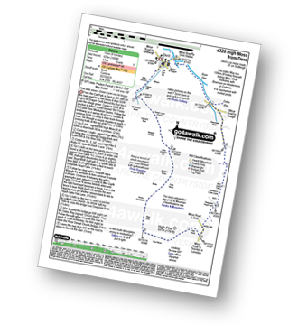
Dent Railway Station - Crosshills Wold - Pikes Moss - Great Knoutberry Hill (Widdale Fell) - Arten Gill Beck - Dent Fell - The Dales Way - Stone House - Cowgill - Dent Railway Station
|
Vital Statistics:
| Length: | 6.25 miles (10 km) |
| Ascent: | 935ft (285m) |
| Time: | 3.25hrs |
| Grade: | |
Route Summary:
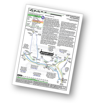
Ilkley - The Dales Way - Swastika Stone - High Moor - Overgate Croft Farm. West Buck Stones - East Buck Stones - Cowper's Cross - Whetstone Gate - Ilkley Moor - Grainings Head - Ilkley
|
Vital Statistics:
| Length: | 6.5 miles (10.5 km) |
| Ascent: | 1,227ft (374m) |
| Time: | 3.75hrs |
| Grade: | |
Route Summary:
Dent Railway Station - Crosshills Wold - Pikes Moss - Great Knoutberry Hill (Widdale Fell) - Arten Gill Beck - Dent Fell - The Dales Way - Stone House - Cowgill - Dent Railway Station
|
Vital Statistics:
| Length: | 6.75 miles (11 km) |
| Ascent: | 607ft (185m) |
| Time: | 3.25hrs |
| Grade: | |
Route Summary:
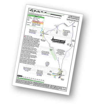
Grassington - The Dales Way - Bank Lathe - Intake Lathe - Moor Lane - Hebden Beck - Loss Gill Bank - Cockbur Ford - Bolton Haw Side - The Mere - Rocking Stone - Care Scar,Hole Bottom - Scale Haw - Knowles Lathe - Side Lathe - High Green - Hebden - The River Wharfe - The Dales Way - Linton Falls - Grassington
|
Vital Statistics:
| Length: | 7.25 miles (11.5 km) |
| Ascent: | 991ft (302m) |
| Time: | 3½ hrs |
| Grade: | |
Route Summary:
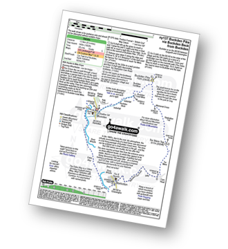
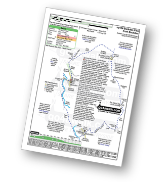
Buckden - Rakes Wood - Buckden Rake - Cray Gill - Cray - Crook Gill - Todd's Wood - Scar House - Strans Gill - Strans Wood - Yockenthwaite - The Dales Way - Hubberholme - The River Wharfe - Wharfedale - Buckden
|
Vital Statistics:
| Length: | 7.25 miles (11.5 km) |
| Ascent: | 210ft (64m) |
| Time: | 3 hrs |
| Grade: |  |
Route Summary:
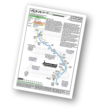
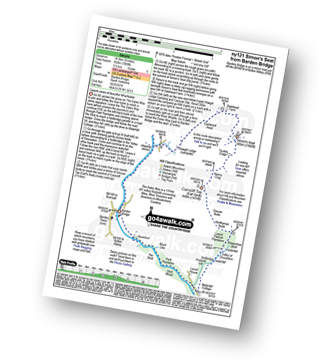
Wharfedale - Bolton Abbey - The Dales Way - The River Wharfe - Wharfedale - Pickles Beck - Stead Dike - Posforth Gill - Black Sike - Bolton Abbey Aqueduct - Barden Bridge - Bolton Abbey Aqueduct - The Strid - Strid Wood - Cavendish Pavilion - Sand Holme - Bolton Priory - Bolton Abbey - Wharfedale
|
Vital Statistics:
| Length: | 7.5 miles (12 km) |
| Ascent: | 787ft (240m) |
| Time: | 3½ hrs |
| Grade: | |
Route Summary:
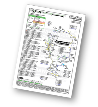
Windermere - Ellery Woods - Orrest Head - Near Orrest Farm - Mislet Farm - Heaning Farm - Blackmoss Farm - School Knott Plantation - School Knott - The Dales Way - High Cleabarrow Farm - Matson Ground - Heaththwaite Manor - Windermere
|
Vital Statistics:
| Length: | 7.5 miles (12 km) |
| Ascent: | 876ft (267m) |
| Time: | 3½ hrs |
| Grade: | |
Route Summary:
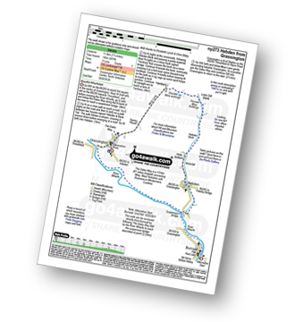
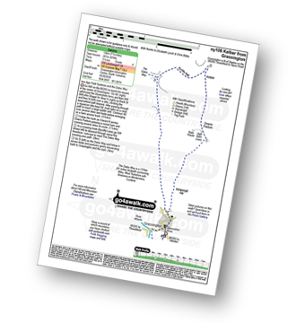
Grassington - Kimpergill Hill - Downs Pasture - Green Hill Pasture - Seeds Hill - Kelber - Bycliffe Road (Track) - The Dales Way - Old Pasture - Lea Green - Grassington
|
Vital Statistics:
| Length: | 7.75 miles (12.5 km) |
| Ascent: | 1,057ft (322m) |
| Time: | 4 hrs |
| Grade: | |
Route Summary:
Ilkley - The Dales Way - Swastika Stone - High Moor - Overgate Croft Farm - West Buck Stones - East Buck Stones - Cowper's Cross - Whetstone Gate - Rombalds Moor (Ilkley Moor) - The Dales Way Link - Gill Head - Ilkley Crags - White Wells - Ilkley
|
Vital Statistics:
| Length: | 8.5 miles (13.5 km) |
| Ascent: | 1,802ft (549m) |
| Time: | 4.75hrs |
| Grade: | |
Route Summary:
Buckden - Buckden Beck - Buckden Lead Mine - Buckden Pike - Fox Memorial - Starbotton Fell - Tor Mere Top - Cam Head - Starbotton Cam Road - Starbotton - The Dales Way - River Wharfe - Wharfedale - Buckden
|
Vital Statistics:
| Length: | 8.5 miles (13.5 km) |
| Ascent: | 1,158ft (353m) |
| Time: | 4.25hrs |
| Grade: | |
Route Summary:
Grassington - Kimpergill Hill - Downs Pasture - Green Hill Pasture - Seeds Hill - Kelber - Bycliffe Road (Track) - The Dales Way - Bull Scar - Davy Dimple - Conistone - Little Lathe - Dib Dale - Bastow Wood - The Dales Way - Grassington
|
Vital Statistics:
| Length: | 9 miles (14.5 km) |
| Ascent: | 19,112ft (583m) |
| Time: | 5.25hrs |
| Grade: |  |
Route Summary:
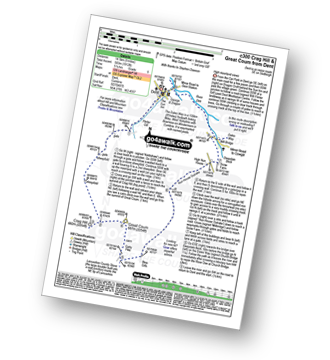
Dent - Flinter Gill - Crag Hill (Great Coum) - Great Coum - Lancashire County Stone - Blea Gills - Nun House Outrake - The Dales Way - River Dee - Dent
|
Vital Statistics:
| Length: | 9 miles (14.5 km) |
| Ascent: | 1,766ft (538m) |
| Time: | 5 hrs |
| Grade: | |
Route Summary:
Buckden - Rakes Wood - Cow Close - Buckden Pike - Fox Memorial - Starbotton Fell - Tor Mere Top - Cam Head - Starbotton Cam Road - Starbotton - The Dales Way - River Wharfe - Wharfedale - Buckden
|
Vital Statistics:
| Length: | 9 miles (14.5 km) |
| Ascent: | 1,805ft (550m) |
| Time: | 5.25hrs |
| Grade: | |
Route Summary:
Wharfedale - Barden Bridge - The River Wharfe - Wharfedale - The Dales Way - The Strid. Strid Wood - Waterfall Cottage - Posforth Gill - Valley of Desolation - Laund Pasture Plantation - Smithyman Nook - Carncliff Top (Earl Seat) - Nanny Crag - Truckle Crags - Simon's Seat (Wharfedale) - Dalehead Farm - Eastwood Head - Howgill Lodge - The Dales Way - The River Wharfe - Barden Bridge - Wharfedale
|
Vital Statistics:
| Length: | 9.5 miles (15 km) |
| Ascent: | 1,404ft (428m) |
| Time: | 5 hrs |
| Grade: | |
Route Summary:
Dent - Flinter Gill - Green Lane - Bill Varry's Moss - Garnet's Man - Megger Stones - Little Coombe Hill - Ralph's Moss - Flow Moss - Robin Constable - High Pike - High Moss - White Shaw - Deepdale Head - Johnston's Lathe - Mire Garth - Dyke Hall Lane - Deepdale Beck - The Dales Way - River Dee - Dent
|
Vital Statistics:
| Length: | 9.5 miles (15 km) |
| Ascent: | 1,906ft (581m) |
| Time: | 5½ hrs |
| Grade: | |
Route Summary:
Buckden - Rakes Wood - Buckden Rake - Cray Gill - Cray - Crook Gill - Todd's Wood - Scar House - Strans Gill - Strans Wood - Yockenthwaite Moor - Yockenthwaite - The Dales Way - Hubberholme - The River Wharfe - Wharfedale - Buckden
|
Vital Statistics:
| Length: | 11.5 miles (18.5 km) |
| Ascent: | 1,017ft (310m) |
| Time: | 5.25hrs |
| Grade: | |
Route Summary:
Grassington - The Dales Way - Lea Green - Old Pasture - Bycliffe Road (Track) - Kelber Gate - Kelber - Seeds Hill - Green Hill Pasture - Downs Pasture - New Pasture Edge - Yarnbury - Hebden Beck - Loss Gill Bank - Cockbur Ford - Bolton Haw Side - The Mere - Rocking Stone - Care Scar,Hole Bottom - Scale Haw - Knowles Lathe - Side Lathe - High Green - Hebden - The River Wharfe - The Dales Way - Linton Falls - Grassington
|
Vital Statistics:
| Length: | 12.25 miles (19.5 km) |
| Ascent: | 2,306ft (703m) |
| Time: | 6.70hrs |
| Grade: |  |
Route Summary:
Dent - Flinter Gill - Green Lane - High Pike - Whernside - Wernside Tarns - Craven Way - Mill Bridge (Deepdale Beck) - The Dales Way - Deepdale Beck - River Dee - Dent
|
Vital Statistics:
| Length: | 12.75 miles (20.5 km) |
| Ascent: | 1,830ft (558m) |
| Time: | 6½ hrs |
| Grade: | |
Route Summary:
Dent - The Dales Way - Barth Bridge - Long Moor - Aye Gill Pike - Rise Hill - Snaizwold Fell - Cowgill - The Dales Way - Dent
|
Vital Statistics:
| Length: | 18 miles (29 km) |
| Ascent: | 2,945ft (898m) |
| Time: | 9½ hrs |
| Grade: |  |
Route Summary:
Dent - The Dales Way - Barth Bridge - Long Moor - Aye Gill Pike - Rise Hill - Little Snaizwold Fell - Snaizwold Fell - Cowgill Wold Moss - Crosshills Wold - Pikes Moss - Great Knoutberry Hill (Widdale Fell) - Arten Gill Beck - Dent Fell - The Dales Way - Stone House - Cowgill - Dent
See this list of walks, routes & maps in:
Grade Order |
Length Order |
Time Order |
Walk Number or Start Location Order
NB. To reverse (toggle) this order, click Length Order again
Not familiar with The Dales Way?
See these 24 walks that include part of The Dales Way on an interactive Google Map


