UK Postcode CA15 - The 30 nearest easy-to-follow, circular walk route maps to you
The thirty nearest easy-to-follow, circular walk route maps to you in UK Postcode CA15 in Walk Grade Order
The UK cities, towns and villages in Cumbria, England that have CA15 in their UK Postcode include:
• Allonby • Broughton Moor • Crosby • Crosscanonby • Dearham • Edderside • Ellenborough • Flimby • Maryport • Mawbray •
Not familiar with the area around CA15?
See these 30 nearest walks to UK Postcode CA15 on a google map
   |
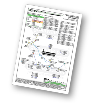
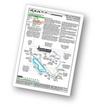
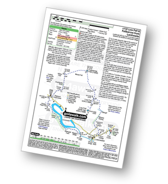
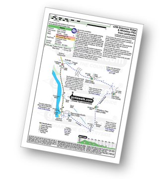
Vital Statistics:
| Length: | 4.5 miles (7 km) |
| Ascent: | 630ft (192m) |
| Time: | 2.25hrs |
| Grade: |  |
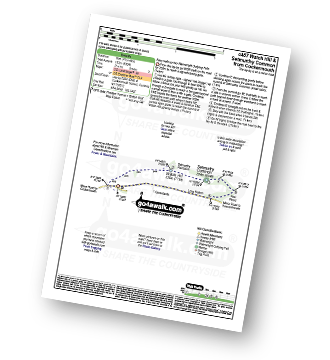
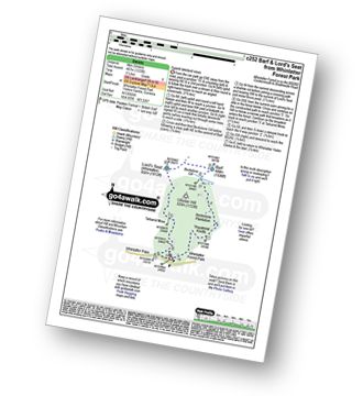
Route Summary:
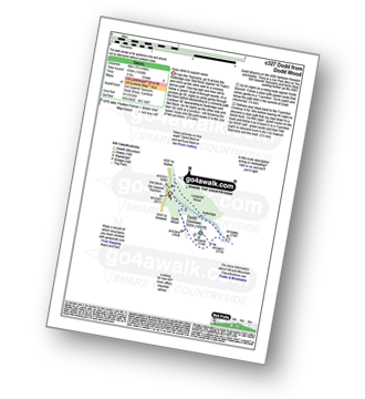
Cockermouth - Watch Hill (Cockermouth) - Hay - Setmurthy Plantation - Setmurthy Common (Watch Hill) - Peel Wood - Long Bottom - Greenlands - Cockermouth
|
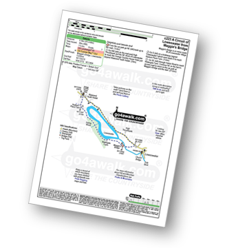
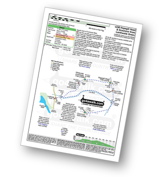
Vital Statistics:
| Length: | 2.5 miles (4 km) |
| Ascent: | 794ft (242m) |
| Time: | 2 hrs |
| Grade: |  |
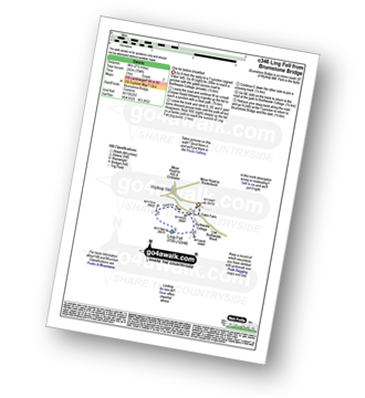
Route Summary:
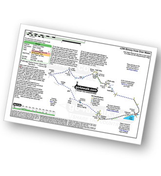
Brumstone Bridge - Eskin Farm - Corpse Road - Ling Fell (Wythop) - Burthwaite Cottage - Brumstone Bridge
|
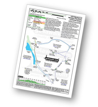
Vital Statistics:
| Length: | 7.5 miles (12 km) |
| Ascent: | 2,091ft (637m) |
| Time: | 5 hrs |
| Grade: |  |
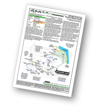
Route Summary:
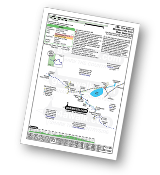
Church of St Margaret - Wythop Mill - Sale Fell - Dodd Crag - Wythop Beck - Esking Farm - Corpse Road - Ling Fell (Wythop) - Burthwaite Cottage - Old Scale - Chapel Wood - Routenbeck - Wythop.
|
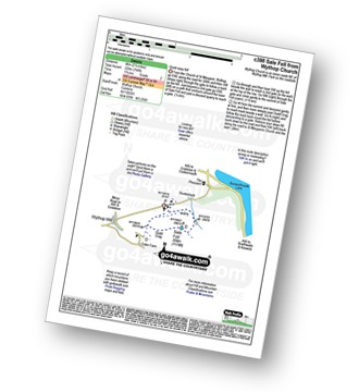
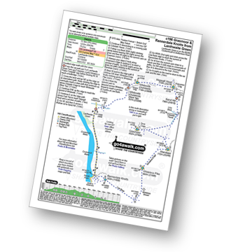
Vital Statistics:
| Length: | 2.5 miles (4 km) |
| Ascent: | 748ft (228m) |
| Time: | 1.75hrs |
| Grade: | |
|
Vital Statistics:
| Length: | 7.25 miles (11.5 km) |
| Ascent: | 3,180ft (969m) |
| Time: | 5.75hrs |
| Grade: | |
Route Summary:
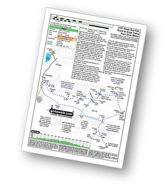
Hopebeck - Hope Beck - Swinside (Whinlatter) - Hope Gill - Ladyside Pike - Hopegill Head - Hobcarton Crag - Grisedale Pike - Hopegill Head - Gasgale Crags - Whiteside (Crummock) - Whiteside (Crummock) (West Top) - Dodd (Whiteside) - Hopebeck
|
Vital Statistics:
| Length: | 4.25 miles (6.5 km) |
| Ascent: | 98ft (30m) |
| Time: | 1½ hrs |
| Grade: |  |
Route Summary:
Maggie's Bridge (Loweswater) - High Thrushbank - Loweswater - Waterend Youth Hostel - Hudson Place Farm - Holme Wood - Watergate Farm - Maggie's Bridge (Loweswater)
|
Vital Statistics:
| Length: | 8.5 miles (13.5 km) |
| Ascent: | 2,540ft (774m) |
| Time: | 6 hrs |
| Grade: | |
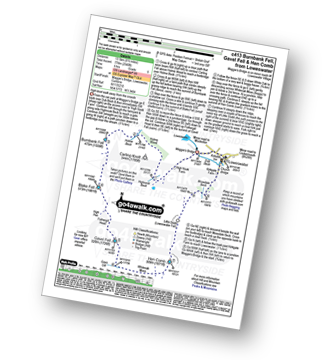
Route Summary:
Maggie's Bridge (Loweswater) - Loweswater - High Nook Farm - Highnook Beck - Holme Wood - Holme Beck - Burnbank Fell - Sharp Knott - Blake Fell - Fothergill Head - Gavel Fell - Grain Gill - Whiteoak Moss - Hen Comb - Little Dodd (Loweswater Fell) - Mosedale (Loweswater) - Mosedale Beck (Loweswater) - Loweswater Village - Maggie's Bridge (Loweswater)
|
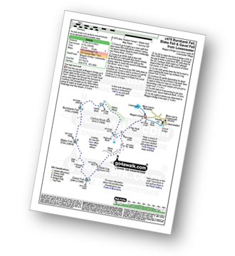
Vital Statistics:
| Length: | 9.5 miles (15 km) |
| Ascent: | 3,666ft (1,117m) |
| Time: | 7.25hrs |
| Grade: |  |
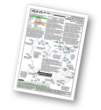
Route Summary:
Maggie's Bridge (Loweswater) - Loweswater - High Nook Farm - Highnook Beck - Holme Wood - Holme Beck - Burnbank Fell - Sharp Knott - Blake Fell - Fothergill Head - Gavel Fell - Grain Gill - Whiteoak Moss - Hen Comb - Thrang Crags - Mosedale (Loweswater) - Mosedale Beck (Loweswater) - Mellbreak - Mellbreak (North Top) - White Crag - Loweswater Village - Maggie's Bridge (Loweswater)
|
Vital Statistics:
| Length: | 7 miles (11 km) |
| Ascent: | 1,726ft (526m) |
| Time: | 4.25hrs |
| Grade: |  |
Route Summary:
Maggie's Bridge (Loweswater) - Acorn Cottage - Crummockwater Cottages and Foulsyke - Pottergill - Raven Crag (Low Fell) - Low Fell - Low Fell (South Top) - Crabtree Beck - Darling Fell - Loweswater - Waterend Youth Hostel - Hudson Place Farm - Holme Wood - Watergate Farm - Maggie's Bridge (Loweswater)
|
Vital Statistics:
| Length: | 6.5 miles (10.5 km) |
| Ascent: | 2,025ft (617m) |
| Time: | 4½ hrs |
| Grade: | |
Route Summary:
Maggie's Bridge (Loweswater) - Loweswater - High Nook Farm - Highnook Beck - Holme Wood - Burnbank Fell - Sharp Knott - Blake Fell - Fothergill Head - Gavel Fell - Black Crag (Gavel Fell) - Highnook Beck - Maggie's Bridge (Loweswater)
|
Vital Statistics:
| Length: | 7.75 miles (12.5 km) |
| Ascent: | 1,923ft (586m) |
| Time: | 4.75hrs |
| Grade: | |
Route Summary:
Maggie's Bridge (Loweswater) - Loweswater - Darling Fell - Crabtree Beck - Low Fell (South Top) - Low Fell - Fellbarrow - Mosser Fell - Wilkes How - Waterend Youth Hostel - Hudson Place Farm - Holme Wood - Watergate Farm - Maggie's Bridge (Loweswater)
|
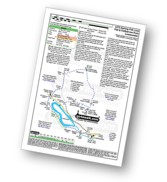
Vital Statistics:
| Length: | 6.25 miles (10 km) |
| Ascent: | 6ft (770m) |
| Time: | 5 hrs |
| Grade: | |
Route Summary:
Maggie's Bridge (Loweswater) - Loweswater - Kirkgate Farm - Raven Crag - White Crag - Mellbreak (North Top) - Mellbreak - Mosedale Beck (Loweswater) - Thrang Crags - Hen Comb - Little Dodd (Loweswater Fell) - Mosedale Beck (Loweswater) - Kirkgate Farm - Loweswater - Maggie's Bridge (Loweswater)
|
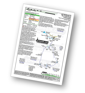
Vital Statistics:
| Length: | 6.5 miles (10.5 km) |
| Ascent: | 1,877ft (572m) |
| Time: | 4.25hrs |
| Grade: | |

Route Summary:
Lanthwaite - Scale Hill - Scalehill Bridge - Muncaster House - Loweswater - Low Park - Mellbreak (North Top) - Mellbreak - Black Beck (Mosedale) - Scale Knott - Scale Beck - High Ling Crag - Low Ling Crag - Crummock Water - Lanthwaite
|
Vital Statistics:
| Length: | 8.75 miles (14 km) |
| Ascent: | 1,884ft (574m) |
| Time: | 5 hrs |
| Grade: | |
Route Summary:
Lanthwaite - Acorn Cottage - Crummockwater Cottages and Foulsyke - Pottergill - Raven Crag (Low Fell) - Low Fell - Low Fell (South Top) - Fellbarrow - Mosser Fell - Wilkes How - Waterend Youth Hostel - Hudson Place Farm - Holme Wood - Watergate Farm - Maggie's Bridge (Loweswater) - Loweswater - Lanthwaite
|
Vital Statistics:
| Length: | 7.25 miles (11.5 km) |
| Ascent: | 3,164ft (964m) |
| Time: | 5.75hrs |
| Grade: | |
Route Summary:
Lanthwaite Green - Liza Beck - Whin Ben - Whiteside (Crummock) (West Top) - Whiteside (Crummock) - Gasgale Crags - Hopegill Head - Hobcarton Crag - Sand Hill - Coledale Hause - Grasmoor - Liza Beck - Gasgale Gill - Lanthwaite
Not familiar with the area around CA15?
See these 30 nearest walks to UK Postcode CA15 on a google map
|
Vital Statistics:
| Length: | 8.5 miles (13.5 km) |
| Ascent: | 2,977ft (907m) |
| Time: | 6 hrs |
| Grade: | |
Route Summary:
Lanthwaite Green - Liza Beck - Gasgale Crags - Gasgale Gill - Coledale Hause - Grasmoor - Wandope - Whiteless Edge - Whiteless Pike - Whiteless Breast - Squat Beck - High Rannerdale - Crummock Water - Lanthwaite Green
|
Vital Statistics:
| Length: | 9.75 miles (15.5 km) |
| Ascent: | 4,043ft (1,232m) |
| Time: | 7.75hrs |
| Grade: | |
Route Summary:
Lanthwaite Green - Liza Beck - Whin Ben - Whiteside (Crummock) (West Top) - Whiteside (Crummock) - Gasgale Crags - Hopegill Head - Sand Hill - Coledale Hause - Grasmoor - Wandope - Whiteless Edge - Whiteless Pike - Whiteless Breast - Low Bank - Rannerdale Knotts - Crummock Water - Hause Point - Lanthwaite Green
|
Vital Statistics:
| Length: | 7 miles (11 km) |
| Ascent: | 3,243ft (988m) |
| Time: | 5.75hrs |
| Grade: | |
Route Summary:
Lanthwaite Green - Grasmoor - Wandope - Whiteless Edge - Whiteless Pike - Whiteless Breast - Low Bank - Rannerdale Knotts - Crummock Water - Lanthwaite Green
|
Vital Statistics:
| Length: | 9 miles (14.5 km) |
| Ascent: | 3,699ft (1,127m) |
| Time: | 7 hrs |
| Grade: | |
Route Summary:
Lanthwaite Green - Liza Beck - Whin Ben - Whiteside (Crummock) (West Top) - Whiteside (Crummock) - Gasgale Crags - Hopegill Head - Hobcarton Crag - Sand Hill - Coledale Hause - Grasmoor - Wandope - Whiteless Edge - Whiteless Pike - Whiteless Breast - Squat Beck - High Rannerdale - Crummock Water - Lanthwaite Green
|
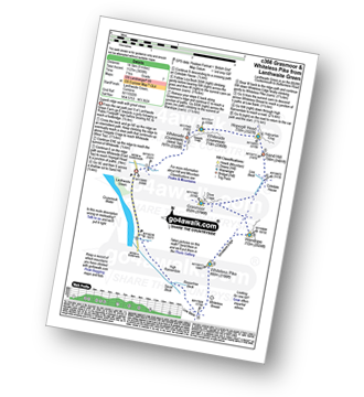
Vital Statistics:
| Length: | 8.25 miles (13 km) |
| Ascent: | 2,919ft (890m) |
| Time: | 6 hrs |
| Grade: | |
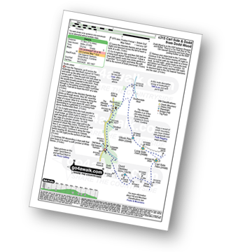
Route Summary:
High Side - The Allerdale Ramble - Ling How - The Edge - Ullock Pike - Longside Edge - Long Side - Carl Side - Skiddaw - Bakestall - Birkett Edge - Whitewater Dash - Back O' Skiddaw - Melbecks - High Side
|
Vital Statistics:
| Length: | 10 miles (16 km) |
| Ascent: | 3,039ft (926m) |
| Time: | 6.75hrs |
| Grade: | |
Route Summary:
Whinlatter Forest Park - Thwaitehill Knotts - Beckstone Plantation - Beckstone Gill - Barf - Lord's Seat (Whinlatter) - Broom Fell - Graystones - Scawgill Bridge - Whinlatter (Brown How) - Whinlatter (Whinlatter Top) - Whinlatter Forest Park
|
Vital Statistics:
| Length: | 5 miles (8 km) |
| Ascent: | 1,533ft (467m) |
| Time: | 3½ hrs |
| Grade: |  |
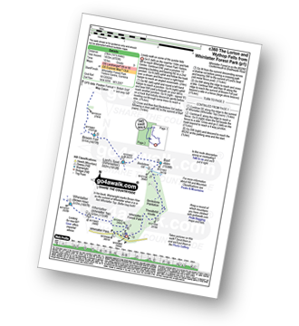
Route Summary:
Whinlatter Forest Park - Thwaitehill Knotts - Beckstone Plantation - Beckstone Gill - Barf - Lord's Seat (Whinlatter) - Whinlatter Forest Park
|
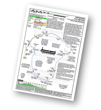
Vital Statistics:
| Length: | 14.5 miles (23 km) |
| Ascent: | 4,703ft (1,433m) |
| Time: | 10 hrs |
| Grade: |  |
Route Summary:
Whinlatter Forest Park - Thwaitehill Knotts - Beckstone Plantation - Beckstone Gill - Barf - Lord's Seat (Whinlatter) - Broom Fell - Low Burthwaite Wood - Kelswick Farm - Sale Fell - Dodd Crag - Eskin Farm - Corpse Road - Ling Fell (Wythop) - Wythop Moss - Graystones - Scawgill Bridge - Whinlatter (Brown How) - - Whinlatter (Whinlatter Top) - Whinlatter Forest Park
|
Vital Statistics:
| Length: | 6.5 miles (10.5 km) |
| Ascent: | 2,573ft (784m) |
| Time: | 5 hrs |
| Grade: | |
Route Summary:
Revelin Moss - Whinlatter Forest Park - Hobcarton End - Grisedale Pike - Hobcarton Crag - Hopegill Head - Ladyside Pike - Swinside Plantation - Whinlatter Pass - Hobcarton Plantation - Revelin Moss
|
Vital Statistics:
| Length: | 7.25 miles (11.5 km) |
| Ascent: | 3,116ft (950m) |
| Time: | 5.75hrs |
| Grade: | |
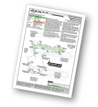
Route Summary:
Old Sawmill Tearooms - Longside Wood - The Allerdale Ramble - Ling How - The Edge - Ullock Pike - Longside Edge - Long Side - Carl Side - White Stones - Skill Beck - Dodd (Skiddaw) - Dodd Wood - Old Sawmill Tearooms
|
Vital Statistics:
| Length: | 4 miles (6.5 km) |
| Ascent: | 1,430ft (436m) |
| Time: | 2.75hrs |
| Grade: | |
Route Summary:
Old Sawmill Tearooms - Longside Wood - Skill Beck - Dodd (Skiddaw) - Dodd Wood - Old Sawmill Tearooms
|
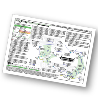
Vital Statistics:
| Length: | 12.25 miles (19.5 km) |
| Ascent: | 3,062ft (933m) |
| Time: | 7½ hrs |
| Grade: | |
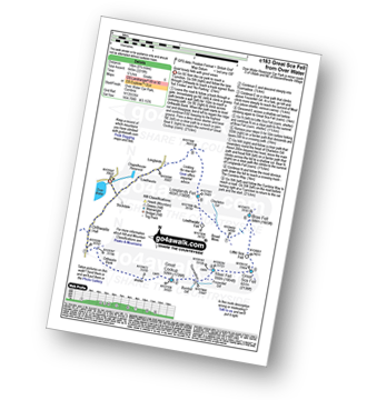
Route Summary:
Over Water Reservoir - Waterside Wood - Whitefield Cottage - Binsey Cottage - Binsey - Dogkennel Wood - Overwater Hall - Black Wood - Orthwaite - Orthwaite Bank - Uldale Fells - Great Cockup - Meal Fell - Great Sca Fell - Little Sca Fell - Brae Fell - Broad Moss - Charleton Gill - Langlands Fell - The Cumbria Way - Lowthwaite - Chapelhouse Reservoir - Over Water
|
Vital Statistics:
| Length: | 7.75 miles (12.5 km) |
| Ascent: | 1,292ft (394m) |
| Time: | 4 hrs |
| Grade: | |
Route Summary:
Over Water Reservoir - Binsey Cottage - Binsey - Whittas Park - High House - High Ireby - Ruthwaite - Scawthwaite Mire - Over Water
|
Vital Statistics:
| Length: | 10.5 miles (17 km) |
| Ascent: | 2,903ft (885m) |
| Time: | 6.75hrs |
| Grade: | |
Route Summary:
Over Water Reservoir - Orthwaite - Orthwaite Bank - Uldale Fells - Great Cockup - Frozenfell Gill - Trusmadoor - Meal Fell - Little Sca Fell - Great Sca Fell - Knott (Uldale Fells) - Little Calva - Great Calva - Hause Gill - Burn Tod - Burntod Gill - Brockle Crags - Orthwaite - Over Water
|
Vital Statistics:
| Length: | 9 miles (14.5 km) |
| Ascent: | 2,624ft (800m) |
| Time: | 6 hrs |
| Grade: | |
Route Summary:
Over Water - Orthwaite - Orthwaite Bank - Uldale Fells - Great Cockup - Trusmadoor - Meal Fell - Great Sca Fell - Little Sca Fell - Brae Fell - Broad Moss - Lowthwaite Fell - Longlands Fell - The Cumbria Way - Longlands - Lowthwaite - Over Water
Not familiar with the area around CA15?
See these 30 nearest walks to UK Postcode CA15 on a google map


