
![]()
Mellbreak
512m (1680ft)
The Western Fells, The Lake District, Cumbria, England
Not familiar with this top?
You can walk/hike to the top of Mellbreak by using any of these 3 easy‑to‑follow route maps:
Walk c354 Mellbreak from Lanthwaite Wood
Short easy scramble to fine views
   |
|---|
Vital Statistics:
| Length: | 6.5ml (10.5km) |
|---|---|
| Ascent: | 1,877ft (572m) |
| Time: | 4.25hrs |
| Grade: |  (Moderate) (Moderate) |
Route Summary:
Lanthwaite - Scale Hill - Scalehill Bridge - Muncaster House - Loweswater - Low Park - Mellbreak (North Top) - Mellbreak - Black Beck (Mosedale) - Scale Knott - Scale Beck - High Ling Crag - Low Ling Crag - Crummock Water - Lanthwaite
Walk c421 Mellbreak and Hen Comb from Loweswater
Short ridge ascent (scramble) to fine views
|
|---|
Vital Statistics:
| Length: | 6.25mls (10km) |
|---|---|
| Ascent: | 6ft (770m) |
| Time: | 5 hrs |
| Grade: |  (Moderate) (Moderate) |

Route Summary:
Maggie's Bridge (Loweswater) - Loweswater - Kirkgate Farm - Raven Crag - White Crag - Mellbreak (North Top) - Mellbreak - Mosedale Beck (Loweswater) - Thrang Crags - Hen Comb - Little Dodd (Loweswater Fell) - Mosedale Beck (Loweswater) - Kirkgate Farm - Loweswater - Maggie's Bridge (Loweswater)
Walk c212 Burnbank Fell, Gavel Fell, Hen Comb and Mellbreak from Loweswater
High level walk away from the crowds
|
|---|
Vital Statistics:
| Length: | 9.5ml (15km) |
|---|---|
| Ascent: | 3,666ft (1,117m) |
| Time: | 7.25hrs |
| Grade: |  (Hard) (Hard) |
Route Summary:
Maggie's Bridge (Loweswater) - Loweswater - High Nook Farm - Highnook Beck - Holme Wood - Holme Beck - Burnbank Fell - Sharp Knott - Blake Fell - Fothergill Head - Gavel Fell - Grain Gill - Whiteoak Moss - Hen Comb - Thrang Crags - Mosedale (Loweswater) - Mosedale Beck (Loweswater) - Mellbreak - Mellbreak (North Top) - White Crag - Loweswater Village - Maggie's Bridge (Loweswater)
See Mellbreak and the surrounding tops on our free-to-access 'Google Style' Peak Bagging Maps:
The Western Fells of The Lake District National Park
Less data - quicker to download
The Whole of The Lake District National Park
More data - might take a little longer to download
See Mellbreak and the surrounding tops on our unique, downloadable, PDF Peak Bagging Maps:

NB: Whether you print off a copy or download it to your phone, these PDF Peak Baggers' Maps might prove incredibly useful when your are up there on the tops and you cannot get a phone signal.
*This version is marked with the walk routes you need to follow to Walk all 214 Wainwrights in just 59 walks.
You can find Mellbreak & all the walks that climb it on these unique free-to-access Interactive Walk Planning Maps:
1:25,000 scale OS Explorer Map (orange/yellow covers):
1:50,000 scale OS Landranger Map (pink/magenta covers):
 Fellow go4awalkers who have already walked, climbed, scaled, summited, hiked & bagged Mellbreak
Caroline Winter walked up Mellbreak on July 12th, 2025 [from/via/route] Lane by Kirkstile Inn, flank of Mellbreak North top, scale force, crummock lake [with] Solo [weather] Heat wave - Desperately hot, so dipped under scale force falls & then a dip in the lake at Low Ling crags. Bitten by a few horse flies. No parking allowed at the inn at weekends unless booked & all the lanes packed with cars.
Ian Ashton climbed it on February 15th, 2025 [with] Ella
Geoff Hand bagged it on September 17th, 2024 [from/via/route] Walk C212 Burnbank fell, Blake fell, Gavel fell, Hen Comb & Mellbreak from Loweswater. What a lovely area, although quite wet. Route finding early on was difficult but once on Burnbank it was quite straight forward. Weather was superb, blue sky all day. Loweswater is lovely. [with] Tess, my Jack Russell [weather] Lovely blue sky all day & warm! - Finding the way up Burnbank was difficult as there didn't appear to be any paths, but after that it was plain sailing. Great climb down Mell break!
Christine Shepherd hiked Mellbreak on May 30th, 2010 [from/via/route] Used walk c212 from Maggie's Bridge Climbed Mellbreak again on 25.09.2021. Went up the scramble & loved it. Climbed up the nose again on 24.2.24 [with] On my own [weather] Bight & sunny - This was the last fell of a good days walking. The descent to Loweswater was a bit steep though!
Simon Myerscough summited on November 5th, 2023 [from/via/route] Buttermere NT car park - was meant to start from Lanthwaite car park but couldn't find it. [with] Joanne [weather] Light winds & sunny spells - Steep scramble (loose rocks) to start climb
To add (or remove) your name and experiences on this page - Log On and edit your Personal Mountain Bagging Record
. . . [see more walk reports]
More Photographs & Pictures of views from, on, or of, Mellbreak
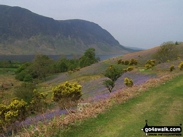
Looking across the bluebells and Crummock Water towards Mellbreak from Rannerdale Knotts
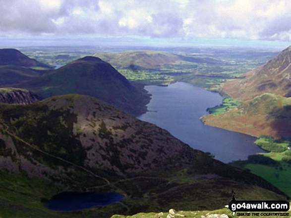

*Ennerdale Water (left), Starling Dodd and Great Borne, Loweswater (right of centre), Mellbreak and Crummock Water (right) from Red Pike (Buttermere)
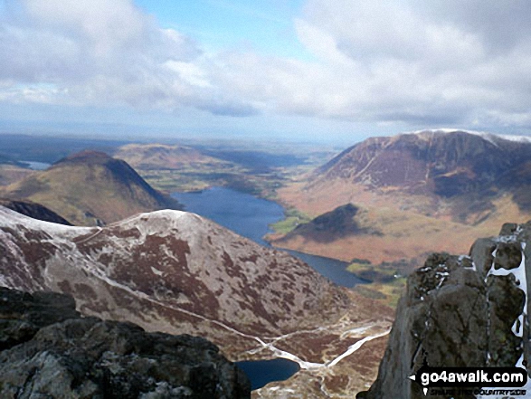
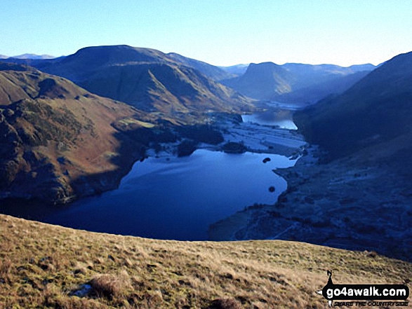
Mellbreak, Crummock Water and Grasmoor with Dodd (Buttermere) and Bleaberry Tarn in the foreground from Red Pike (Buttermere)

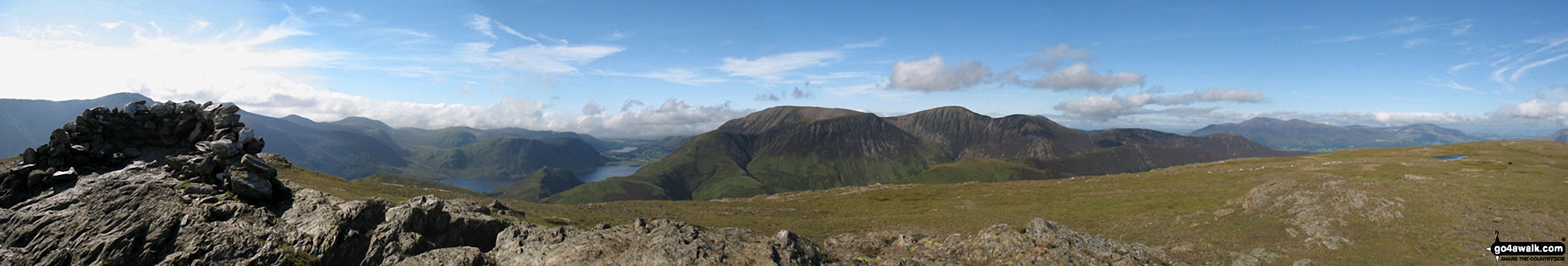
The summit shelter, Mellbreak, Rannerdale Knotts, Buttermere, Grasmoor, Whiteless Pike, Wandope, Crag Hill (Eel Crag), Sail and Knott Rigg from the summit of Robinson

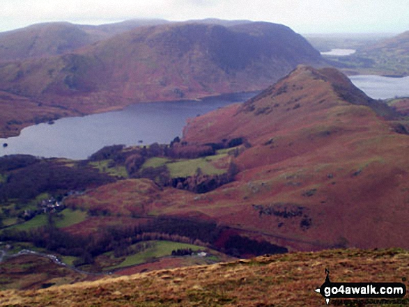
Rannerdale Knotts (foreground) and Crummack Water with Mellbreak beyond from High Snockrigg
. . . see all 52 walk photographs & pictures of views from, on, or of, Mellbreak
Send us your photographs and pictures on, of, or from Mellbreak
If you would like to add your walk photographs and pictures to this page, please send them as email attachments (configured for any computer) along with your name to:
and we shall do our best to publish them.
(Guide Resolution = 300dpi. At least = 660pixels (wide) x 440 pixels (high).)

You can also submit photos via our Facebook Page.
NB. Please indicate where each photo was taken and whether you wish us to credit your photos with a Username or your First Name/Last Name.


