7 easy to follow walk route maps of all grades that include part of The North Cheshire Way
The North Cheshire Way is a 113km (70 miles) linear footpath connecting Hooton Station in Cheshire, with Disley Station in Cheshire, England.
The North Cheshire Way is waymarked by the letter NCW.
Not familiar with The North Cheshire Way?
See these 7 walks that include part of The North Cheshire Way on an interactive Google Map
See this list of walks, routes & maps in:
Grade Order |
Length Order |
Time Order |
Walk Number or Start Location Order
NB. To reverse (toggle) this order, click Grade Order again
   |
Vital Statistics:
| Length: | 3.75 miles (6 km) |
| Ascent: | 253ft (77m) |
| Time: | 2 hrs |
| Grade: |  |
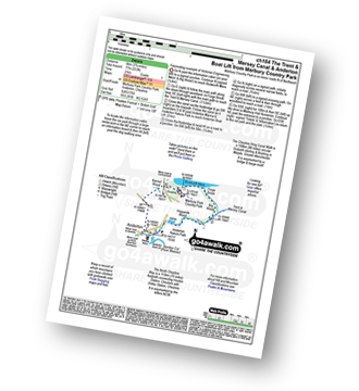
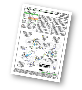
Route Summary:
Marbury Country Park - Forge Brook - Big Wood - Trent and Mersey Canal - The Cheshire Ring Walk - Anderton - Anderton Boat Lift - Kennel Wood - The North Cheshire Way - Marbury Country Park.
|
Vital Statistics:
| Length: | 4 miles (6.5 km) |
| Ascent: | 272ft (83m) |
| Time: | 1.75hrs |
| Grade: |  |
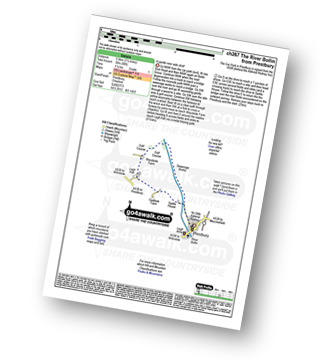
Route Summary:
Prestbury - The River Bollin - The North Cheshire Way - Woodside Farm - Legh Hall - Woodend Farm - Spittle House - Prestbury
|
Vital Statistics:
| Length: | 5 miles (8 km) |
| Ascent: | 226ft (69m) |
| Time: | 2.25hrs |
| Grade: | |
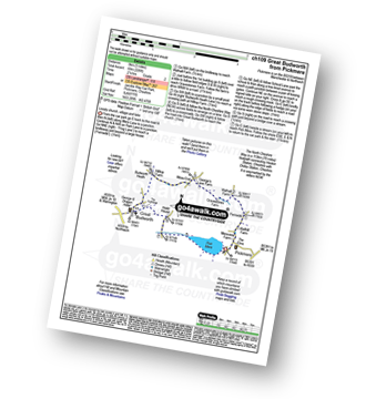
Route Summary:
Pickmere - Wathall Farm - Moss End - Hilltop Farm - The North Cheshire Way - Great Budworth - Pick Mere - Pickmere
|
Vital Statistics:
| Length: | 4.5 miles (7 km) |
| Ascent: | 715ft (218m) |
| Time: | 2½ hrs |
| Grade: |  |
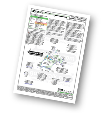
Route Summary:
Lyme Park Car Park - Lyme Park Country Park - Pursefield Wood - Paddock Cottage,Knightslow Wood, - Higher Moor - Lantern Wood - The Cage - The North Cheshire Way - Lyme Hall - Lyme Park Car Park
|
Vital Statistics:
| Length: | 7 miles (11 km) |
| Ascent: | 824ft (251m) |
| Time: | 3.25hrs |
| Grade: |  |
Route Summary:
Nelson Pit Visitors Centre - Higher Poynton - The Macclesfield Canal - The Cheshire Ring Canal Walk - Wood Lanes - Adlington Basin - Lockgate Farm - The North Cheshire Way - Harrop Brow - West Parkgate - Lyme Park Country Park - Lyme Park Car Park - The Cage - Lyme Hall - Fallow Deer Park - The Lime Avenue - Lyme Park Car Park - Windgather Farm - Haresteads Farm - Nelson Pit Visitors Centre - Higher Poynton.
|
Vital Statistics:
| Length: | 7.25 miles (11.5 km) |
| Ascent: | 1,201ft (366m) |
| Time: | 3.75hrs |
| Grade: | |
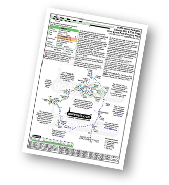
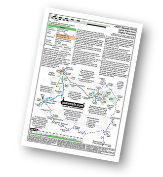
Route Summary:
Lyme Park Car Park - Crow Wood - Hase Bank Wood - West Parkgate - The North Cheshire Way - Keepers' Cottage - Dale Top - Sponds Moor - The Gritstone Trail - Sponds Hill - Bow Stones - Bowstonegate Farm - Lyme Park Country Park - Lantern Wood - The Cage - Fallow Deer Park - The Lime Avenue - Lyme Park Car Park
|
Vital Statistics:
| Length: | 9.75 miles (15.5 km) |
| Ascent: | 9ft (409m) |
| Time: | 5 hrs |
| Grade: |  |
Route Summary:
Nelson Pit Visitors Centre - Higher Poynton - The Macclesfield Canal - The Cheshire Ring Canal Walk - Wood Lanes - Adlington Basin - Lockgate Farm - The North Cheshire Way - Harrop Brow - Birchencliff Farm - Keeper's Cottage - Dale Top - Sponds Moor - The Gritstone Trail - Sponds Hill - Bowstonegate Farm - Bow Stones - Higher Moor - Lyme Park Country Park - Lantern Wood - The Cage - Lyme Hall - Fallow Deer Park - The Lime Avenue - Lyme Park Car Park - Windgather Farm - Haresteads Farm - Nelson Pit Visitors Centre - Higher Poynton.
See this list of walks, routes & maps in:
Grade Order |
Length Order |
Time Order |
Walk Number or Start Location Order
NB. To reverse (toggle) this order, click Grade Order again
Not familiar with The North Cheshire Way?
See these 7 walks that include part of The North Cheshire Way on an interactive Google Map


