7 easy to follow walk route maps of all grades that include part of The North Cheshire Way
Seven easy-to-follow walk route maps of all grades that include part of The North Cheshire Way in Walk Grade Order
The North Cheshire Way is a 113km (70 miles) linear footpath connecting Hooton Station in Cheshire, with Disley Station in Cheshire, England.
The North Cheshire Way is waymarked by the letter NCW.
Tap/mouse over a coloured circle (1-3 easy walks, 4-6 moderate walks, 7-9 hard walks) and click to select.
You can use these checkboxes to show only the grades of walk you are interested in:-
See this list of walks, routes & maps in:
Grade Order | Length Order | Time Order | Walk Number or Start Location Order
NB. To reverse (toggle) this order, click Grade Order again
Scroll down the list of walks below & click on each walk title (in blue) to locate it on the map above.
   |
Vital Statistics:
| Length: | 5 miles (8 km) |
| Ascent: | 226ft (69m) |
| Time: | 2.25hrs |
| Grade: |  |
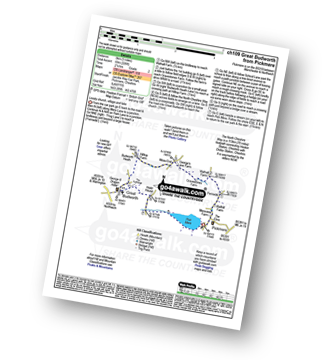
Route Summary:
Pickmere - Wathall Farm - Moss End - Hilltop Farm - The North Cheshire Way - Great Budworth - Pick Mere - Pickmere
|
Vital Statistics:
| Length: | 3.75 miles (6 km) |
| Ascent: | 253ft (77m) |
| Time: | 2 hrs |
| Grade: |  |
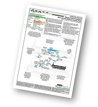
Route Summary:
Marbury Country Park - Forge Brook - Big Wood - Trent and Mersey Canal - The Cheshire Ring Walk - Anderton - Anderton Boat Lift - Kennel Wood - The North Cheshire Way - Marbury Country Park.
|
Vital Statistics:
| Length: | 9.75 miles (15.5 km) |
| Ascent: | 9ft (409m) |
| Time: | 5 hrs |
| Grade: |  |
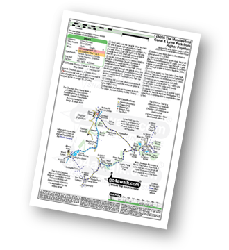
Route Summary:
Nelson Pit Visitors Centre - Higher Poynton - The Macclesfield Canal - The Cheshire Ring Canal Walk - Wood Lanes - Adlington Basin - Lockgate Farm - The North Cheshire Way - Harrop Brow - Birchencliff Farm - Keeper's Cottage - Dale Top - Sponds Moor - The Gritstone Trail - Sponds Hill - Bowstonegate Farm - Bow Stones - Higher Moor - Lyme Park Country Park - Lantern Wood - The Cage - Lyme Hall - Fallow Deer Park - The Lime Avenue - Lyme Park Car Park - Windgather Farm - Haresteads Farm - Nelson Pit Visitors Centre - Higher Poynton.
|
Vital Statistics:
| Length: | 7 miles (11 km) |
| Ascent: | 824ft (251m) |
| Time: | 3.25hrs |
| Grade: |  |
Route Summary:
Nelson Pit Visitors Centre - Higher Poynton - The Macclesfield Canal - The Cheshire Ring Canal Walk - Wood Lanes - Adlington Basin - Lockgate Farm - The North Cheshire Way - Harrop Brow - West Parkgate - Lyme Park Country Park - Lyme Park Car Park - The Cage - Lyme Hall - Fallow Deer Park - The Lime Avenue - Lyme Park Car Park - Windgather Farm - Haresteads Farm - Nelson Pit Visitors Centre - Higher Poynton.
|
Vital Statistics:
| Length: | 4 miles (6.5 km) |
| Ascent: | 272ft (83m) |
| Time: | 1.75hrs |
| Grade: | |
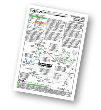
Route Summary:
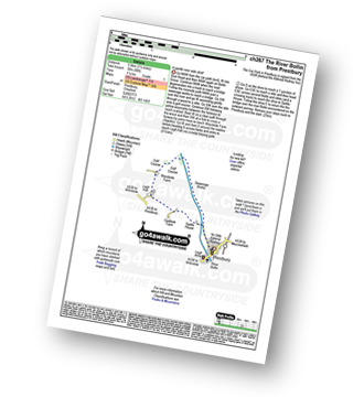
Prestbury - The River Bollin - The North Cheshire Way - Woodside Farm - Legh Hall - Woodend Farm - Spittle House - Prestbury
|
Vital Statistics:
| Length: | 4.5 miles (7 km) |
| Ascent: | 715ft (218m) |
| Time: | 2½ hrs |
| Grade: |  |
Route Summary:
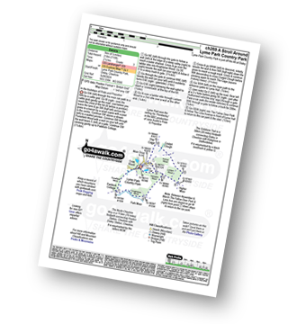
Lyme Park Car Park - Lyme Park Country Park - Pursefield Wood - Paddock Cottage,Knightslow Wood, - Higher Moor - Lantern Wood - The Cage - The North Cheshire Way - Lyme Hall - Lyme Park Car Park
|
Vital Statistics:
| Length: | 7.25 miles (11.5 km) |
| Ascent: | 1,201ft (366m) |
| Time: | 3.75hrs |
| Grade: | |
Route Summary:
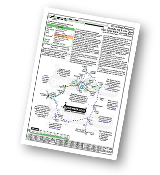
Lyme Park Car Park - Crow Wood - Hase Bank Wood - West Parkgate - The North Cheshire Way - Keepers' Cottage - Dale Top - Sponds Moor - The Gritstone Trail - Sponds Hill - Bow Stones - Bowstonegate Farm - Lyme Park Country Park - Lantern Wood - The Cage - Fallow Deer Park - The Lime Avenue - Lyme Park Car Park
See this list of walks, routes & maps in:
Grade Order | Length Order | Time Order | Walk Number or Start Location Order
NB. To reverse (toggle) this order, click Grade Order again


