12 easy to follow walk route maps of all grades that include part of The Manifold Way
Twelve easy-to-follow walk route maps of all grades that include part of The Manifold Way in Walk Time Order (Longest to Shortest)
The Manifold Way is a 13km (8 miles) linear footpath connecting Hulme End in Staffordshire, England with Waterhouses in Staffordshire, England.
Originally a 2ft 6in (0.762m) gauge light railway for tourists the line was opened in 1904. Never a great success it was finally closed in 1934 and became a bridleway three years later.
The Manifold Way is waymarked by named posts.
Tap/mouse over a coloured circle (1-3 easy walks, 4-6 moderate walks, 7-9 hard walks) and click to select.
You can use these checkboxes to show only the grades of walk you are interested in:-
See this list of walks, routes & maps in:
Grade Order |
Length Order |
Time Order |
Walk Number or Start Location Order
NB. To reverse (toggle) this order, click Time Order (Longest to Shortest) again
Scroll down the list of walks below & click on each walk title (in blue) to locate it on the map above.
   |
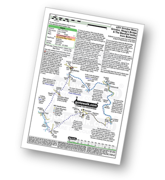
Vital Statistics:
| Length: | 10.5 miles (17 km) |
| Ascent: | 1,847ft (563m) |
| Time: | 5.75hrs |
| Grade: |  |
Route Summary:
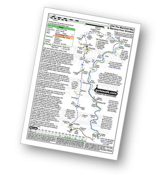
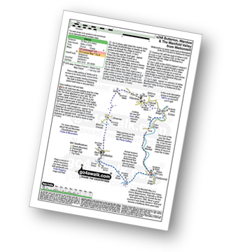
Grindon - Weag's Bridge - The Manifold Way - The River Manifold - Thor's Cave - Dafar Bridge - Wettonmill - Ecton Bridge - Dale Bridge - Ecton - Hulme End - Hollow Farm - Warslow Hall - Upper Brownhill Farm - Warslow - Villa Farm - Clayton House - Wallacre - Hoo Brook - Ladyside Farm - Grindon
|
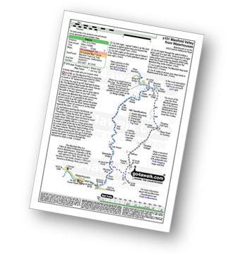
Vital Statistics:
| Length: | 11.5 miles (18 km) |
| Ascent: | 1,267ft (386m) |
| Time: | 5½ hrs |
| Grade: |  |
Route Summary:
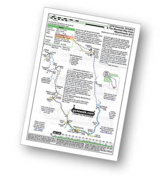
Waterhouses - Waterfall Cross - Martins Low - River Hamps - Ford - Onecote - Grindonmoor Gate - Grindon Moor (Grindon Moor) - Grindon - Lee House - The Manifold Way - Waterhouses
|
Vital Statistics:
| Length: | 10.25 miles (16.5 km) |
| Ascent: | 1,486ft (453m) |
| Time: | 5.25hrs |
| Grade: | |
Route Summary:
Ilam - The Manifold Trail - Ilam Country Park - River Manifold - Castern Hall - Castern Wood Nature Reserve - Weag's Bridge - The Manifold Way - The River Hamps - Manifold Valley - Lee House Farm - Throwley Moor - Slade House - Rushley - Ilam Country Park - Ilam
|
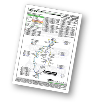
Vital Statistics:
| Length: | 8.75 miles (14 km) |
| Ascent: | 1,848ft (563m) |
| Time: | 5 hrs |
| Grade: | |
Route Summary:
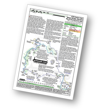
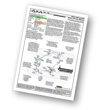
Hulme End - Manifold Valley Visitors Centre - The Manifold Way - Dale Bridge - The Lee - Tunnel - River Manifold - Wetton Mill Farm - Wettonmill - Dafar Bridge - Ladyside Wood - Wetton - Wetton Hill (South West Top) - Wetton Hill - Cantrell's House - Ecton Hill - Westside Mill - The Manifold Way - Hulme End
|
Vital Statistics:
| Length: | 8.75 miles (14 km) |
| Ascent: | 1,690ft (515m) |
| Time: | 5 hrs |
| Grade: | |
Route Summary:
Butterton - Grindon Moor (Grindon Moor) - Ford - Ryebrook Farm - Grindon - Weag's Bridge - The Manifold Way - The River Manifold - Thor's Cave - Ladyside Wood - Dafar Bridge - Wettonmill - Hoo Brook - Butterton
|
Vital Statistics:
| Length: | 8.25 miles (13 km) |
| Ascent: | 1,588ft (484m) |
| Time: | 4½ hrs |
| Grade: | |
Route Summary:
Waterhouses - The Manifold Way - The River Hamps - Sparrowlee Bridge - Lee House - Hell Hole - Old Soles Wood - Soles Coppice - The River Manifold - Weag's Bridge - Beeston Tor Farm - Throwley Hall Farm - Throwley Cottage - Farwall Farm - The Manifold Way - Waterhouses
|
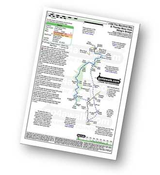
Vital Statistics:
| Length: | 6 miles (9.5 km) |
| Ascent: | 1,034ft (315m) |
| Time: | 3.25hrs |
| Grade: |  |
Route Summary:
Hulme End - Manifold Valley Visitors Centre - The Manifold Way - Dale Bridge - The Lee - Tunnel - River Manifold - Wetton Mill Farm - Wettonmill - Dale Farm - Sugarloaf (Wetton) - Broad Ecton Farm - Ecton Hill - Westside Mill - The Manifold Way - Hulme End
|
Vital Statistics:
| Length: | 6.5 miles (10.5 km) |
| Ascent: | 689ft (210m) |
| Time: | 3.25hrs |
| Grade: | |
Route Summary:
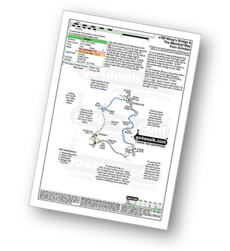
Weag's Bridge - River Manifold - The Manifold Way - River Hamps - Lee House Farm - Farwell Farm - Calton - Slade House - Throwley Moor - Soles Hollow - The Manifold Way - River Manifold - Weag's Bridge
|
Vital Statistics:
| Length: | 7 miles (10.5 km) |
| Ascent: | 787ft (240m) |
| Time: | 3.25hrs |
| Grade: |  |
Route Summary:
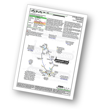
Wettonmill - Hoo Brook - Butterton - Warslow - Dale Bridge - Ecton - The Manifold Way - The River Manifold - Manifold Valley - Wettonmill
|
Vital Statistics:
| Length: | 4.75 miles (7.5 km) |
| Ascent: | 909ft (277m) |
| Time: | 3 hrs |
| Grade: |  |
Route Summary:
Grindon - Weag's Bridge - The Manifold Way - Thor's Cave - Wettonmill - Hoo Brook - Grindon
|
Vital Statistics:
| Length: | 4.5 miles (7 km) |
| Ascent: | 623ft (190m) |
| Time: | 2.25hrs |
| Grade: | |
Route Summary:
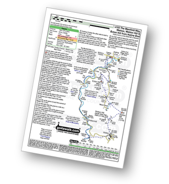
Wetton - River Manifold - Wettonmill - The Manifold Way - Thor's Cave - Manor House - Wetton
|
Vital Statistics:
| Length: | 3.75 miles (6 km) |
| Ascent: | 289ft (88m) |
| Time: | 1.75hrs |
| Grade: | |
Route Summary:
Hulme End - Manifold Valley Visitors Centre - Lowend - Low End Farm - Buttsend - Brund - The Manifold Way - The River Manifold - Brund Mill - Holme House - Hulme End
See this list of walks, routes & maps in:
Grade Order |
Length Order |
Time Order |
Walk Number or Start Location Order
NB. To reverse (toggle) this order, click Time Order (Longest to Shortest) again


