The Mountains, Peaks, Tops and Hills in Northumberland National Park with all the tops you are yet to climb first & then the ones you have already bagged in second.
The Northumberland National Park is located in North Eastern England and wholly within the county of Northumberland.
If you include just the Mountains (Hewitts), the Deweys and the Nuttalls there are 24 tops to climb, bag & conquer and the highest point is The Cheviot at 815m (2,674ft).
To see these Mountains, Peaks, Tops and Hills displayed in different ways - see the options in the left-hand column and towards the bottom of this page.
![]() Your Personal Bagging Record for Northumberland
Your Personal Bagging Record for Northumberland
When logged on, you can mark each Mountain, Peak, Top or Hill as 'bagged' by either:
- if you opt to display the tops in this area using a google map, click or tap on its symbol on the map below. This will open a text window. Click or tap on the 'Record [mountain name] as Bagged, Climbed & Conquered' link towards the bottom of the text window, or
- if you opt to display the tops in this area as a list, click or tap on the red 'not yet' symbol to the right of the name of each 'top'
Either method will open a new page where you can complete all your details such as:
- when you bagged the Mountain, Peak, Top or Hill;
- which route you took
- who you went with
- what the weather was like
- any other comment that will remind you of the day
Once you have completed your details and click or tap the submit button, you will automatically return to this page and the top you bagged will show with a green tick.
NB. None of the above fields are 'mandatory' - you can leave them blank if you wish.
NNB. You also have the option whether to display your peak bagging exploits to other users of this site or keep them private so only you can see them when you are logged on.
Furthermore, since you can also access your Personal Mountain & Hill Bagging Record via go4awalk Mobile you can quickly & easily record, edit and view your achievements - whether you are at home/work on your desktop computer or in the pub/at the top of a mountain with your Mobile Phone. (You can even download your Personal Mountain & Hill Bagging Record as a .csv file for importing into and saving with spreadsheet software like Excel or NeoOffice!)
This facility costs one credit to initially access your personal bagging record. Once accessed, all other interactions, such as recording other Mountains, Peaks, Tops and Hills as 'bagged' or altering an existing bagging record, are free.
Click REGISTER to register and purchase credits.
LOG ON and RELOAD this page to show which Mountains, Peaks, Tops and Hills you have already climbed, bagged & conquered. [ . . . remove this text]
Scroll down this list of mountains, peaks, tops & hills below and tap/click on each name (in blue) to locate it on the map above.
See this list in: Alphabetical Order‡ | Height Order
To reverse the order select the link again.
Top yet to be climbed, bagged & conquered:
Bagged

![]()
1. Beefstand Hill
562m (1844ft)
Dewey
See more details, photos, trip reports and easy-to-follow walks up Beefstand Hill
![]()
2. Birnie Brae
508m (1667ft)
Dewey
See more details, photos, trip reports and easy-to-follow walks up Birnie Brae
![]()
3. Black Hag (Hethpool)
549m (1801ft)
Dewey
See more details, photos, trip reports and easy-to-follow walks up Black Hag (Hethpool)

![]()
4. Bloodybush Edge
610m (2001ft)
Mountain (Hewitt) and Nuttall
See more details, photos, trip reports and easy-to-follow walks up Bloodybush Edge
![]()
5. Broadhope Hill
517m (1696ft)
Dewey
See more details, photos, trip reports and easy-to-follow walks up Broadhope Hill
![]()
6. Brownhart Law
508m (1667ft)
Dewey
See more details, photos, trip reports and easy-to-follow walks up Brownhart Law
![]()
7. Comb Fell
652m (2139ft)
Mountain (Hewitt) and Nuttall
See more details, photos, trip reports and easy-to-follow walks up Comb Fell
![]()
8. Cushat Law
616m (2022ft)
Mountain (Hewitt) and Nuttall
See more details, photos, trip reports and easy-to-follow walks up Cushat Law
![]()
9. Dunmoor Hill
569m (1867ft)
Dewey
See more details, photos, trip reports and easy-to-follow walks up Dunmoor Hill
![]()
10. Glendhu Hill
514m (1686ft)
Dewey
See more details, photos, trip reports and easy-to-follow walks up Glendhu Hill
![]()
11. Hedgehope Hill
714m (2343ft)
Mountain (Hewitt) and Nuttall
See more details, photos, trip reports and easy-to-follow walks up Hedgehope Hill
![]()
12. Hungry Law
501m (1644ft)
Dewey
See more details, photos, trip reports and easy-to-follow walks up Hungry Law
![]()
13. Lint Lands
510m (1673ft)
Dewey
See more details, photos, trip reports and easy-to-follow walks up Lint Lands
![]()
14. Newton Tors
537m (1762ft)
Dewey
See more details, photos, trip reports and easy-to-follow walks up Newton Tors
![]()
15. Preston Hill
526m (1726ft)
Dewey
See more details, photos, trip reports and easy-to-follow walks up Preston Hill
![]()
16. Ravens Knowe
527m (1729ft)
Dewey
See more details, photos, trip reports and easy-to-follow walks up Ravens Knowe
![]()
17. Shill Moor
528m (1732ft)
Dewey
See more details, photos, trip reports and easy-to-follow walks up Shill Moor
![]()
18. Shillhope Law
501m (1644ft)
Dewey
See more details, photos, trip reports and easy-to-follow walks up Shillhope Law
![]()
19. The Cheviot
815m (2674ft)
Mountain (Hewitt) and Nuttall
See more details, photos, trip reports and easy-to-follow walks up The Cheviot
![]()
20. The Schil
601m (1972ft)
Dewey
See more details, photos, trip reports and easy-to-follow walks up The Schil
![]()
21. Thirl Moor
558m (1831ft)
Dewey
See more details, photos, trip reports and easy-to-follow walks up Thirl Moor
![]()
22. Wether Cairn (Wholhope Hill)
563m (1847ft)
Dewey
See more details, photos, trip reports and easy-to-follow walks up Wether Cairn (Wholhope Hill)
![]()
23. Windy Gyle
619m (2031ft)
Mountain (Hewitt) and Nuttall
See more details, photos, trip reports and easy-to-follow walks up Windy Gyle
![]()
24. Yarnspath Law
543m (1782ft)
Dewey
See more details, photos, trip reports and easy-to-follow walks up Yarnspath Law
Mountain, Peak, Top or Hill already bagged:
Bagged
![]() Your Personal Bagging Record for Northumberland
Your Personal Bagging Record for Northumberland
When logged on, you can mark each Mountain, Peak, Top or Hill as 'bagged' by either:
- if you opt to display the tops in this area using a google map, click or tap on its symbol on the map below. This will open a text window. Click or tap on the 'Record [mountain name] as Bagged, Climbed & Conquered' link towards the bottom of the text window, or
- if you opt to display the tops in this area as a list, click or tap on the red 'not yet' symbol to the right of the name of each 'top'
Either method will open a new page where you can complete all your details such as:
- when you bagged the Mountain, Peak, Top or Hill;
- which route you took
- who you went with
- what the weather was like
- any other comment that will remind you of the day
Once you have completed your details and click or tap the submit button, you will automatically return to this page and the top you bagged will show with a green tick.
NB. None of the above fields are 'mandatory' - you can leave them blank if you wish.
NNB. You also have the option whether to display your peak bagging exploits to other users of this site or keep them private so only you can see them when you are logged on.
Furthermore, since you can also access your Personal Mountain & Hill Bagging Record via go4awalk Mobile you can quickly & easily record, edit and view your achievements - whether you are at home/work on your desktop computer or in the pub/at the top of a mountain with your Mobile Phone. (You can even download your Personal Mountain & Hill Bagging Record as a .csv file for importing into and saving with spreadsheet software like Excel or NeoOffice!)
This facility costs one credit to initially access your personal bagging record. Once accessed, all other interactions, such as recording other Mountains, Peaks, Tops and Hills as 'bagged' or altering an existing bagging record, are free.
Click REGISTER to register and purchase credits.
LOG ON and RELOAD this page to show which Mountains, Peaks, Tops and Hills you have already climbed, bagged & conquered. [ . . . remove this text]
View these 24 Mountains, Peaks, Tops and Hills:
- On an Interactive Google Map (loads faster)
- On an Interactive Google Map with a list of tops below it.
(makes it easier to locate a particular top) - On a Detailed List in:
Alphabetical Order | Height Order - On one page with 'yet-to-be-bagged' listed 1st & then 'already-bagged' tops listed 2nd in:
Alphabetical Order | Height Order - On one page with 'already-bagged' tops listed 1st & then 'yet-to-be-bagged' tops listed 2nd in:
Alphabetical Order | Height Order
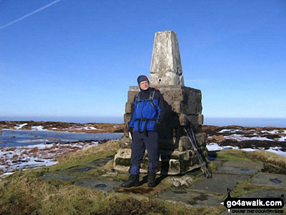 The summit of The Cheviot in Northumberland
Photo: Julian Whitley
Is there a Mountain, Peak, Top or Hill missing from the above google map or list?


