
![]()
The Cheviot
815m (2674ft)
Northumberland National Park, Northumberland, England
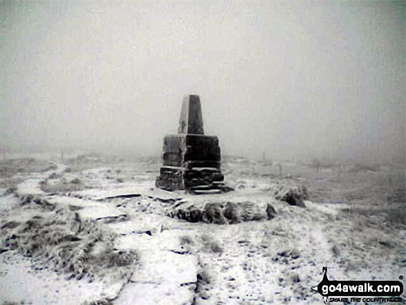
The summit of The Cheviot is marked by an Ordnance Survey Trig Point.

Not familiar with this top?
You can walk/hike to the top of The Cheviot by using any of these 5 easy‑to‑follow route maps:
Walk n101 The Cheviot from Harthope Burn Valley
Up and down Northumberland's biggest
   |
|---|
Vital Statistics:
| Length: | 7ml (11km) |
|---|---|
| Ascent: | 2,022ft (616m) |
| Time: | 4½ hrs |
| Grade: |  (Moderate) (Moderate) |

Route Summary:
Harthope Burn Valley - Hawsen Burn Parking Area - New Burn - Scald Hill - The Cheviot - Scald Hill - New Burn - Hawsen Burn Parking Area.
Walk n119 The Cheviot and Cairn Hill from Harthope Burn Velley
Circular walk up Northumberlands highest
|
|---|
Vital Statistics:
| Length: | 8.5ml (13.5km) |
|---|---|
| Ascent: | 2,114ft (644m) |
| Time: | 5½ hrs |
| Grade: |  (Moderate) (Moderate) |

Route Summary:
Harthope Burn Valley - Hawsen Burn Parking Area - New Burn - Scald Hill - The Cheviot - Cairn Hill (Scotsmans Cairn) - Harthope Burn - Hrthope Linn - Langleeford Hope - Cat Loup - Ray Burn - Langleeford Farm - Hawsen Burn Parking Area.
Walk n132 The Cheviot, Comb Fell and Hedgehope Hill from Harthope Burn Valley
Fabulous high level walk
|
|---|
Vital Statistics:
| Length: | 9.5ml (15.5km) |
|---|---|
| Ascent: | 2,800ft (853m) |
| Time: | 6½ hrs |
| Grade: |  (Hard) (Hard) |

Route Summary:
Harthope Burn Valley - Hawsen Burn Parking Area - New Burn - Scald Hill - The Cheviot - Cairn Hill (Scotsmans Cairn) - Harthope Burn - Comb Fell - Hedgehope Hill - Long Crags - Housey Crags - Hawsen Burn Parking Area.
Walk n111 The Cheviot and Cold Law from Harthope Burn Valley
Fabulous views of the Northumberland coast
|
|---|
Vital Statistics:
| Length: | 10.5ml (17km) |
|---|---|
| Ascent: | 2,614ft (797m) |
| Time: | 6½ hrs |
| Grade: | (Hard) |

Route Summary:
Harthope Burn Valley - Cold Law - Broadhope Hill - Scald Hill - The Cheviot - The Pennine Way - Harthope Burn - Langleeford Hope - Langleeford - Harthope Burn Valley
Walk n167 The Cheviot from Hethpool
Testing Northumberland High Level Route
|
|---|
Vital Statistics:
| Length: | 16.5ml (26.5km) |
|---|---|
| Ascent: | 3,144ft (958m) |
| Time: | 9.25hrs |
| Grade: |  (Hard) (Hard) |

Route Summary:
Hethpool - College Valley - Whitehall - Fleehope - Mounthooly - Birnie Brae - The Pennine Way - Red Cribs - Auchope Cairn - Cairn Hill - The Cheviot - Scald Hill - Goldcleugh - Lambden Burn - Dunsdale - Coldburn - Southernknowe - Whitehall - Hethpool
See The Cheviot and the surrounding tops on our free-to-access 'Google Style' Peak Bagging Map:
You can find The Cheviot & all the walks that climb it on these unique free-to-access Interactive Walk Planning Maps:
1:25,000 scale OS Explorer Map (orange/yellow covers):
1:50,000 scale OS Landranger Maps (pink/magenta covers):
 Fellow go4awalkers who have already walked, climbed, scaled, summited, hiked & bagged The Cheviot
David Peebles walked up The Cheviot on May 10th, 2024 [from/via/route] Monster Walk from Wedder Leap Carpark is doing 44Km circular I made. [with] Solo walk [weather] Great Sunshine. 19 Degrees bit too hot.
Caroline Winter climbed it on July 25th, 2021 [from/via/route] Langleeford, Hedgehope Hill, Comb Fell, Cairn hill, The Cheviot [with] Becky & Andy [weather] Fog 50 M visibity, drizzle, warm & light breeze - Forecast inaccurate today, expecting good views by 1 pm, but not clear until 2.30pm, so had some views on descent. Busiest section of walk, with people walking up to do The Cheviot
Ginny Tyler bagged it on August 5th, 2020 [from/via/route] Car Park [with] Enzo [weather] Pleasant - Chilly at the Summit
Angela Haworth hiked The Cheviot on October 29th, 2001 [with] Alone [weather] Dry
Margaret Richards summited on May 10th, 2010 [from/via/route] Pennine way [with] Don [weather] Sunny
To add (or remove) your name and experiences on this page - Log On and edit your Personal Mountain Bagging Record
. . . [see more walk reports]
More Photographs & Pictures of views from, on, or of, The Cheviot

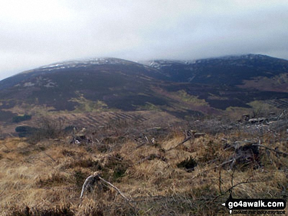
On the summit of The Cheviot - go4awalk n132 The Cheviot, Comb Fell & Hedgehope Hill - on not a very nice day.

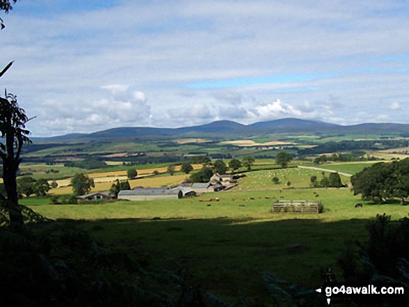
Looking north to The Cheviot (left) and Hedgehope Hill from the summit of Cushat Law

. . . see all 28 walk photographs & pictures of views from, on, or of, The Cheviot
Send us your photographs and pictures on, of, or from The Cheviot
If you would like to add your walk photographs and pictures to this page, please send them as email attachments (configured for any computer) along with your name to:
and we shall do our best to publish them.
(Guide Resolution = 300dpi. At least = 660pixels (wide) x 440 pixels (high).)

You can also submit photos via our Facebook Page.
NB. Please indicate where each photo was taken and whether you wish us to credit your photos with a Username or your First Name/Last Name.


