The Mountains, Peaks, Tops and Hills in The Eastern Fells area of The Lake District, Cumbria with all the tops you have already bagged in first & then the ones you are yet to climb second.
The Eastern Fells area of The Lake District National Park, Cumbria is enclosed by:
- Threlkeld and Pooley Bridge to the North
- Grasmere and Thirlmere to the West
- Ambleside to the South
- The Kirkstone Pass and Ullswater to the East
If you include just the Mountains (Hewitts) and the Nuttalls there are 26 tops to climb, bag & conquer and the highest point is Helvellyn at 950m (3,118ft).
To see these Mountains, Peaks, Tops and Hills displayed in different ways - see the options in the left-hand column and towards the bottom of this page.
![]() Your Personal Bagging Record for The Eastern Fells area of The Lake District
Your Personal Bagging Record for The Eastern Fells area of The Lake District
When logged on, you can mark each Mountain, Peak, Top or Hill as 'bagged' by either:
- if you opt to display the tops in this area using a google map, click or tap on its symbol on the map below. This will open a text window. Click or tap on the 'Record [mountain name] as Bagged, Climbed & Conquered' link towards the bottom of the text window, or
- if you opt to display the tops in this area as a list, click or tap on the red 'not yet' symbol to the right of the name of each 'top'
Either method will open a new page where you can complete all your details such as:
- when you bagged the Mountain, Peak, Top or Hill;
- which route you took
- who you went with
- what the weather was like
- any other comment that will remind you of the day
Once you have completed your details and click or tap the submit button, you will automatically return to this page and the top you bagged will show with a green tick.
NB. None of the above fields are 'mandatory' - you can leave them blank if you wish.
NNB. You also have the option whether to display your peak bagging exploits to other users of this site or keep them private so only you can see them when you are logged on.
Furthermore, since you can also access your Personal Mountain & Hill Bagging Record via go4awalk Mobile you can quickly & easily record, edit and view your achievements - whether you are at home/work on your desktop computer or in the pub/at the top of a mountain with your Mobile Phone. (You can even download your Personal Mountain & Hill Bagging Record as a .csv file for importing into and saving with spreadsheet software like Excel or NeoOffice!)
This facility costs one credit to initially access your personal bagging record. Once accessed, all other interactions, such as recording other Mountains, Peaks, Tops and Hills as 'bagged' or altering an existing bagging record, are free.
Click REGISTER to register and purchase credits.
LOG ON and RELOAD this page to show which Mountains, Peaks, Tops and Hills you have already climbed, bagged & conquered. [ . . . remove this text]
Scroll down this list of mountains, peaks, tops & hills below and tap/click on each name (in blue) to locate it on the map above.
See this list in: Alphabetical Order | Height Order‡
To reverse the order select the link again.
Mountain, Peak, Top or Hill already bagged:
Bagged
Top yet to be climbed, bagged & conquered:
Bagged

![]()
1. Helvellyn
950m (3118ft)
Mountain (Hewitt) and Nuttall
See more details, photos, trip reports and easy-to-follow walks up Helvellyn

![]()
2. Lower Man (Helvellyn)
925m (3036ft)
Nuttall
See more details, photos, trip reports and easy-to-follow walks up Lower Man (Helvellyn)
![]()
3. Nethermost Pike
891m (2924ft)
Nuttall
See more details, photos, trip reports and easy-to-follow walks up Nethermost Pike
![]()
4. Catstye Cam
890m (2921ft)
Mountain (Hewitt) and Nuttall
See more details, photos, trip reports and easy-to-follow walks up Catstye Cam
![]()
5. Raise (Helvellyn)
883m (2898ft)
Mountain (Hewitt) and Nuttall
See more details, photos, trip reports and easy-to-follow walks up Raise (Helvellyn)
![]()
6. Fairfield
873m (2865ft)
Mountain (Hewitt) and Nuttall
See more details, photos, trip reports and easy-to-follow walks up Fairfield
![]()
7. White Side
863m (2832ft)
Mountain (Hewitt) and Nuttall
See more details, photos, trip reports and easy-to-follow walks up White Side
![]()
8. Striding Edge (High Spying How)
863m (2831ft)
Mountain (Hewitt) and Nuttall
See more details, photos, trip reports and easy-to-follow walks up Striding Edge (High Spying How)
![]()
9. Dollywaggon Pike
858m (2816ft)
Mountain (Hewitt) and Nuttall
See more details, photos, trip reports and easy-to-follow walks up Dollywaggon Pike
![]()
10. Great Dodd
857m (2813ft)
Mountain (Hewitt) and Nuttall
See more details, photos, trip reports and easy-to-follow walks up Great Dodd
![]()
11. Stybarrow Dodd
843m (2767ft)
Mountain (Hewitt) and Nuttall
See more details, photos, trip reports and easy-to-follow walks up Stybarrow Dodd
![]()
12. St Sunday Crag
841m (2760ft)
Mountain (Hewitt) and Nuttall
See more details, photos, trip reports and easy-to-follow walks up St Sunday Crag
![]()
13. Hart Crag
822m (2698ft)
Mountain (Hewitt) and Nuttall
See more details, photos, trip reports and easy-to-follow walks up Hart Crag
![]()
14. Green Side (White Stones)
795m (2609ft)
Nuttall
See more details, photos, trip reports and easy-to-follow walks up Green Side (White Stones)
![]()
15. Dove Crag
792m (2599ft)
Mountain (Hewitt) and Nuttall
See more details, photos, trip reports and easy-to-follow walks up Dove Crag
![]()
16. Red Screes
776m (2547ft)
Mountain (Hewitt) and Nuttall
See more details, photos, trip reports and easy-to-follow walks up Red Screes
![]()
17. Great Rigg
766m (2514ft)
Mountain (Hewitt) and Nuttall
See more details, photos, trip reports and easy-to-follow walks up Great Rigg
![]()
18. Hart Side
756m (2481ft)
Nuttall
See more details, photos, trip reports and easy-to-follow walks up Hart Side
![]()
19. Seat Sandal
736m (2417ft)
Mountain (Hewitt) and Nuttall
See more details, photos, trip reports and easy-to-follow walks up Seat Sandal
![]()
20. Clough Head
726m (2383ft)
Mountain (Hewitt) and Nuttall
See more details, photos, trip reports and easy-to-follow walks up Clough Head
![]()
21. Birkhouse Moor
718m (2356ft)
Nuttall
See more details, photos, trip reports and easy-to-follow walks up Birkhouse Moor
![]()
22. Sheffield Pike
676m (2218ft)
Mountain (Hewitt) and Nuttall
See more details, photos, trip reports and easy-to-follow walks up Sheffield Pike
![]()
23. Little Hart Crag
637m (2091ft)
Mountain (Hewitt) and Nuttall
See more details, photos, trip reports and easy-to-follow walks up Little Hart Crag
![]()
24. Birks
624m (2047ft)
Nuttall
See more details, photos, trip reports and easy-to-follow walks up Birks
![]()
25. Rydal Fell (Heron Pike North Top)
621m (2038ft)
Nuttall
See more details, photos, trip reports and easy-to-follow walks up Rydal Fell (Heron Pike North Top)
![]()
26. Heron Pike
612m (2008ft)
Nuttall
See more details, photos, trip reports and easy-to-follow walks up Heron Pike
![]() Your Personal Bagging Record for The Eastern Fells area of The Lake District
Your Personal Bagging Record for The Eastern Fells area of The Lake District
When logged on, you can mark each Mountain, Peak, Top or Hill as 'bagged' by either:
- if you opt to display the tops in this area using a google map, click or tap on its symbol on the map below. This will open a text window. Click or tap on the 'Record [mountain name] as Bagged, Climbed & Conquered' link towards the bottom of the text window, or
- if you opt to display the tops in this area as a list, click or tap on the red 'not yet' symbol to the right of the name of each 'top'
Either method will open a new page where you can complete all your details such as:
- when you bagged the Mountain, Peak, Top or Hill;
- which route you took
- who you went with
- what the weather was like
- any other comment that will remind you of the day
Once you have completed your details and click or tap the submit button, you will automatically return to this page and the top you bagged will show with a green tick.
NB. None of the above fields are 'mandatory' - you can leave them blank if you wish.
NNB. You also have the option whether to display your peak bagging exploits to other users of this site or keep them private so only you can see them when you are logged on.
Furthermore, since you can also access your Personal Mountain & Hill Bagging Record via go4awalk Mobile you can quickly & easily record, edit and view your achievements - whether you are at home/work on your desktop computer or in the pub/at the top of a mountain with your Mobile Phone. (You can even download your Personal Mountain & Hill Bagging Record as a .csv file for importing into and saving with spreadsheet software like Excel or NeoOffice!)
This facility costs one credit to initially access your personal bagging record. Once accessed, all other interactions, such as recording other Mountains, Peaks, Tops and Hills as 'bagged' or altering an existing bagging record, are free.
Click REGISTER to register and purchase credits.
LOG ON and RELOAD this page to show which Mountains, Peaks, Tops and Hills you have already climbed, bagged & conquered. [ . . . remove this text]
View these 26 Mountains, Peaks, Tops and Hills:
- On a Downloadable PDF you can Print or Save to your Phone#
- On an Interactive Google Map with a list of tops below it.
(makes it easier to locate a particular top) - On a Detailed List in:
Alphabetical Order | Height Order - On one page with 'yet-to-be-bagged' listed 1st
& then 'already-bagged' tops listed 2nd in:
Alphabetical Order | Height Order - On one page with 'already-bagged' tops listed 1st
& then 'yet-to-be-bagged' tops listed 2nd in:
Alphabetical Order | Height Order
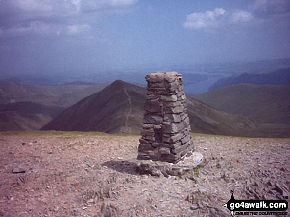 The summit of Helvellyn in The Eastern Fells area of The Lake District
Photo: William Ringwood
# Whether you print a copy or download it to your phone, this Peak Baggers' Map will prove incredibly useful if you want to know what's what when you are up in the mountains and cannot get a phone signal.
Is there a Mountain, Peak, Top or Hill missing from the above google map or list?


