36 easy-to-follow circular walk route maps of all grades in The North Western Fells area of The Lake District
Thirty-six easy-to-follow, hand-crafted walks including routes from Braithwaite, Brumstone Bridge, Buttermere, Derwent Water, Hawes End, Hopebeck, Little Town, Lanthwaite Green, Seatoller & Whinlatter that climb the Grasmoor (the highest point), Cat Bells, Dale Head, Hindscarth, Hobcarton Crag, Robinson, High Snockrigg & Rannerdale Knotts amongst others. More details about each walk can be found below the map.
The North Western Fells area of The Lake District National Park is enclosed by:
- Basenthwaite to the North East
- Keswick, Derwent Water and Borrowdale to the East
- Seatoller and Honister Pass to the South
- Buttermere, Crummock Water & Lorton Vale to the South West
- Cockermouth and the boundary of the Lake District National Park to the West and North West
Tap/mouse over a coloured circle (1-3 easy walks, 4-6 moderate walks, 7-9 hard walks) and click to select.
You can use these checkboxes to show only the grades of walk you are interested in:-
Scroll down the list of walks below & click on each walk title (in blue) to locate it on the map above.
See this list of walks, routes & maps in:
Grade Order | Length Order | Time Order | Walk Number or Start Location Order
NB. To reverse (toggle) this order, click Grade Order again
   |
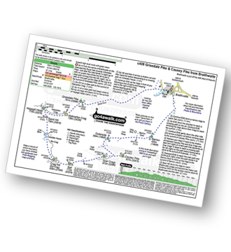
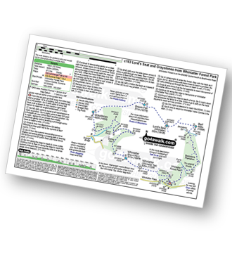
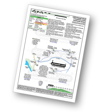
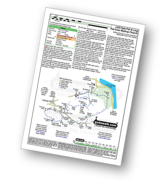
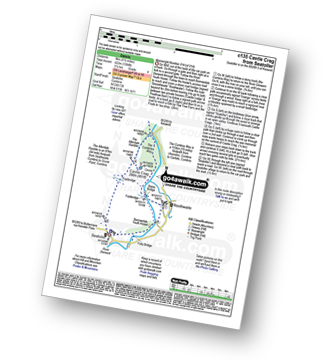
Vital Statistics:
| Length: | 12 miles (19 km) |
| Ascent: | 5,261ft (1,603m) |
| Time: | 9.75hrs |
| Grade: |  |
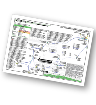
Route Summary:
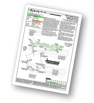
Braithwaite - Sleet How - Grisedale Pike - Hobcarton Crag - Hopegill Head - Sand Hill - Coledale Hause - Grasmoor - Wandope - Crag Hill (Eel Crag) - Sail (Derwent Fells) - Scar Crags - Causey Pike - Outerside - Stile End - Barrow (Newlands) - Braithwaite
|
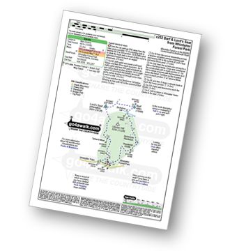
Vital Statistics:
| Length: | 14.5 miles (23 km) |
| Ascent: | 4,703ft (1,433m) |
| Time: | 10 hrs |
| Grade: | |
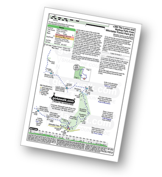
Route Summary:
Whinlatter Forest Park - Thwaitehill Knotts - Beckstone Plantation - Beckstone Gill - Barf - Lord's Seat (Whinlatter) - Broom Fell - Low Burthwaite Wood - Kelswick Farm - Sale Fell - Dodd Crag - Eskin Farm - Corpse Road - Ling Fell (Wythop) - Wythop Moss - Graystones - Scawgill Bridge - Whinlatter (Brown How) - - Whinlatter (Whinlatter Top) - Whinlatter Forest Park
|
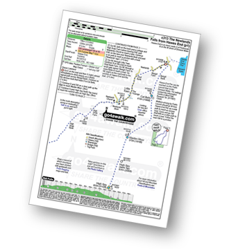
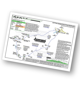
Vital Statistics:
| Length: | 14.5 miles (23 km) |
| Ascent: | 5,409ft (1,648m) |
| Time: | 11 hrs |
| Grade: | |
Route Summary:
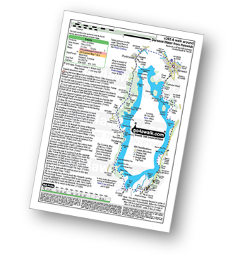
Hawes End - Derwent Water - Skelgill Bank - Woodford's Path - Cat Bells (Catbells) - Maiden Moor - High Spy (North Top) - High Spy - Dalehead Tarn - Dale Head (Newlands) - Hindscarth - Littledale Edge - Robinson - High Snockrigg - Moss Force - Newlands Hause - Knott Rigg - Ard Crags - Birkrigg - Keskerdale Beck - Newlands Church - Newlands Beck - Little Town - Skelgill Farm - Hawes End Derwent Water.
|
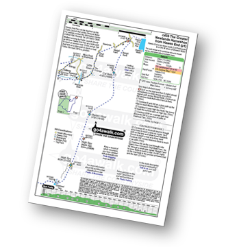
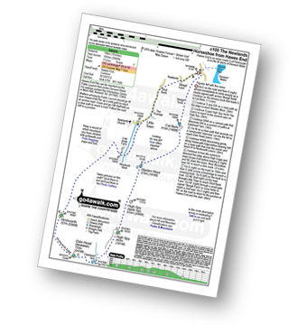
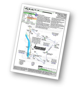
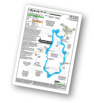
Vital Statistics:
| Length: | 12 miles (19 km) |
| Ascent: | 4,152ft (1,266m) |
| Time: | 8½ hrs |
| Grade: |  |
Route Summary:
Hawes End - Derwent Water - Skelgill Bank - Woodford's Path - Cat Bells (Catbells) - Maiden Moor - High Spy (North Top) - High Spy - Dale Head Tarn - Dale Head (Newlands) - Hindscarth Edge - Hindscarth - Littledale Edge - Robinson - High Snab Bank - Newlands Church - Little Town - Hawes End - Derwent Water.
|
Vital Statistics:
| Length: | 10 miles (16 km) |
| Ascent: | 4,641ft (1,414m) |
| Time: | 8½ hrs |
| Grade: | |
Route Summary:
Braithwaite - Sleet How - Grisedale Pike - Hobcarton Crag - Hopegill Head - Sand Hill - Coledale Hause - Crag Hill (Eel Crag) - Sail (Derwent Fells) - Scar Crags - Causey Pike - Outerside - Stile End - Barrow (Newlands) - Braithwaite
|
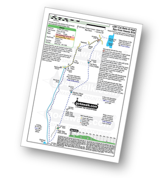
Vital Statistics:
| Length: | 10.25 miles (16.5 km) |
| Ascent: | 3,585ft (1,093m) |
| Time: | 7½ hrs |
| Grade: |  |
Route Summary:
Hawes End - Derwent Water - Skelgill Bank - Woodford's Path - Cat Bells (Catbells) - Maiden Moor - High Spy (North Top) - High Spy - Dalehead Tarn - Dale Head (Newlands) - Hindscarth - High Crags - Scope End - Low Snab Farm - Newlands Church - Little Town - Newlands Valley - Hawes End - Derwent Water.
|
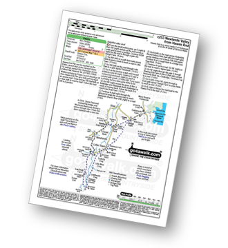
Vital Statistics:
| Length: | 8.5 miles (13.5 km) |
| Ascent: | 3,840ft (1,170m) |
| Time: | 7 hrs |
| Grade: | |
Route Summary:
Braithwaite - Sleet How - Grisedale Pike - Hobcarton Crag - Hopegill Head - Sand Hill - Coldale Hause - Eel Crag - Crag Hill (Eel Crag) - Sail (Derwent Fells) - Long Comb - High Moss - Low Moss - Barrow Door - Braithwaite
|
Vital Statistics:
| Length: | 8.75 miles (14 km) |
| Ascent: | 3,073ft (937m) |
| Time: | 6.25hrs |
| Grade: | |
Route Summary:
Little Town - High Snab Bank - Blea Crags - Robinson - Littledale Edge - Hindscarth - Hindscarth Edge - Dale Head (Newlands) - Dalehead Tarn - Newlands Valley - Newlands Church - Little Town
|
Vital Statistics:
| Length: | 10 miles (16 km) |
| Ascent: | 3,039ft (926m) |
| Time: | 6.75hrs |
| Grade: | |
Route Summary:
Whinlatter Forest Park - Thwaitehill Knotts - Beckstone Plantation - Beckstone Gill - Barf - Lord's Seat (Whinlatter) - Broom Fell - Graystones - Scawgill Bridge - Whinlatter (Brown How) - Whinlatter (Whinlatter Top) - Whinlatter Forest Park
|
Vital Statistics:
| Length: | 9 miles (14.5 km) |
| Ascent: | 3,699ft (1,127m) |
| Time: | 7 hrs |
| Grade: | |
Route Summary:
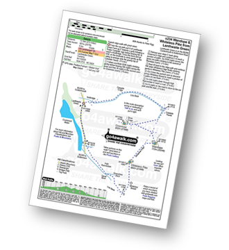
Lanthwaite Green - Liza Beck - Whin Ben - Whiteside (Crummock) (West Top) - Whiteside (Crummock) - Gasgale Crags - Hopegill Head - Hobcarton Crag - Sand Hill - Coledale Hause - Grasmoor - Wandope - Whiteless Edge - Whiteless Pike - Whiteless Breast - Squat Beck - High Rannerdale - Crummock Water - Lanthwaite Green
|
Vital Statistics:
| Length: | 10 miles (16 km) |
| Ascent: | 3,349ft (1,082m) |
| Time: | 7.25hrs |
| Grade: | |
Route Summary:
Hawes End - Derwent Water - Skelgill Bank - Woodford's Path - Cat Bells (Catbells) - Maiden Moor - Narrow Moor - High Spy (North Top) - High Spy - Dale Head Tarn - Rigghead Quarries - The Allerdale Ramble - Castle Crag - River Derwent - Yewdale Knott - Manesty - Manesty Band - Hawes End - Derwent Water.
|
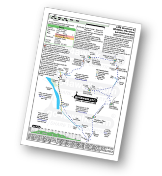
Vital Statistics:
| Length: | 9.75 miles (15.5 km) |
| Ascent: | 4,043ft (1,232m) |
| Time: | 7.75hrs |
| Grade: | |
Route Summary:
Lanthwaite Green - Liza Beck - Whin Ben - Whiteside (Crummock) (West Top) - Whiteside (Crummock) - Gasgale Crags - Hopegill Head - Sand Hill - Coledale Hause - Grasmoor - Wandope - Whiteless Edge - Whiteless Pike - Whiteless Breast - Low Bank - Rannerdale Knotts - Crummock Water - Hause Point - Lanthwaite Green
|
Vital Statistics:
| Length: | 6.5 miles (10.5 km) |
| Ascent: | 2,573ft (784m) |
| Time: | 5 hrs |
| Grade: |  |
Route Summary:
Revelin Moss - Whinlatter Forest Park - Hobcarton End - Grisedale Pike - Hobcarton Crag - Hopegill Head - Ladyside Pike - Swinside Plantation - Whinlatter Pass - Hobcarton Plantation - Revelin Moss
|
Vital Statistics:
| Length: | 7.25 miles (11.5 km) |
| Ascent: | 3,180ft (969m) |
| Time: | 5.75hrs |
| Grade: | |
Route Summary:
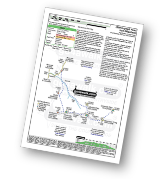
Hopebeck - Hope Beck - Swinside (Whinlatter) - Hope Gill - Ladyside Pike - Hopegill Head - Hobcarton Crag - Grisedale Pike - Hopegill Head - Gasgale Crags - Whiteside (Crummock) - Whiteside (Crummock) (West Top) - Dodd (Whiteside) - Hopebeck
|
Vital Statistics:
| Length: | 7.25 miles (11.5 km) |
| Ascent: | 2,654ft (809m) |
| Time: | 5½ hrs |
| Grade: | |
Route Summary:
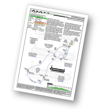
Little Town - Newlands Valley - Low Snab Farm - Scope End - High Crags - Hindscarth - Littledale Edge - Robinson - Blea Crags - High Snab Bank - High Snab Farm - Newlands Church - Little Town
|
Vital Statistics:
| Length: | 8.5 miles (13.5 km) |
| Ascent: | 2,977ft (907m) |
| Time: | 6 hrs |
| Grade: | |
Route Summary:
Lanthwaite Green - Liza Beck - Gasgale Crags - Gasgale Gill - Coledale Hause - Grasmoor - Wandope - Whiteless Edge - Whiteless Pike - Whiteless Breast - Squat Beck - High Rannerdale - Crummock Water - Lanthwaite Green
|
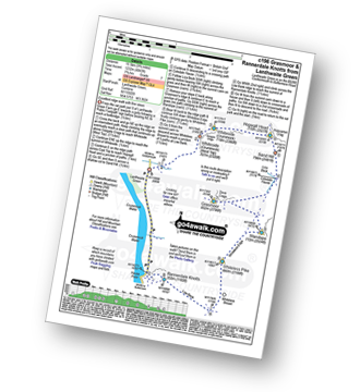
Vital Statistics:
| Length: | 7.25 miles (11.5 km) |
| Ascent: | 3,164ft (964m) |
| Time: | 5.75hrs |
| Grade: | |
Route Summary:
Lanthwaite Green - Liza Beck - Whin Ben - Whiteside (Crummock) (West Top) - Whiteside (Crummock) - Gasgale Crags - Hopegill Head - Hobcarton Crag - Sand Hill - Coledale Hause - Grasmoor - Liza Beck - Gasgale Gill - Lanthwaite
|
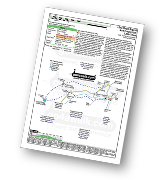
Vital Statistics:
| Length: | 7 miles (11 km) |
| Ascent: | 3,243ft (988m) |
| Time: | 5.75hrs |
| Grade: | |
Route Summary:
Lanthwaite Green - Grasmoor - Wandope - Whiteless Edge - Whiteless Pike - Whiteless Breast - Low Bank - Rannerdale Knotts - Crummock Water - Lanthwaite Green
|
Vital Statistics:
| Length: | 8.25 miles (13 km) |
| Ascent: | 2,512ft (766m) |
| Time: | 5½ hrs |
| Grade: | |
Route Summary:
Hawes End - Derwent Water - Newlands Valley - Skelgill Bank - Woodford's Path - Cat Bells (Catbells) - Maiden Moor - High Spy (North Top) - High Spy - Dalehead Tarn - Newlands Valley - Newlands Church - Little Town - Hawes End
|
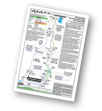
Vital Statistics:
| Length: | 7.25 miles (11.5 km) |
| Ascent: | 3,013ft (918m) |
| Time: | 5.75hrs |
| Grade: | |
Route Summary:
Braithwaite - Barrow (Newlands) - Stile End - Low Moss - Outerside - High Moss - Scar Crags - Causey Pike - Sleet Hause - Rowling End - Stoneycroft - Braithwaite
|
Vital Statistics:
| Length: | 7.5 miles (12 km) |
| Ascent: | 2,091ft (637m) |
| Time: | 5 hrs |
| Grade: | |
Route Summary:
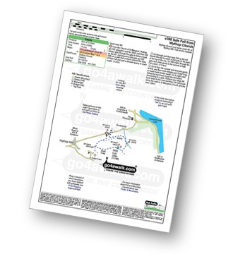
Church of St Margaret - Wythop Mill - Sale Fell - Dodd Crag - Wythop Beck - Esking Farm - Corpse Road - Ling Fell (Wythop) - Burthwaite Cottage - Old Scale - Chapel Wood - Routenbeck - Wythop.
|
Vital Statistics:
| Length: | 6 miles (9.5 km) |
| Ascent: | 1,894ft (577m) |
| Time: | 4 hrs |
| Grade: |  |
Route Summary:
Little Town - Newlands Church - Keskerdale Farm - Knott Rigg - Ard Crags - Rigg Beck - Birkrigg - Gillbrow - Little Town
|
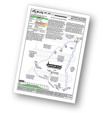
Vital Statistics:
| Length: | 4.75 miles (7.5 km) |
| Ascent: | 2,363ft (720m) |
| Time: | 4.25hrs |
| Grade: | |
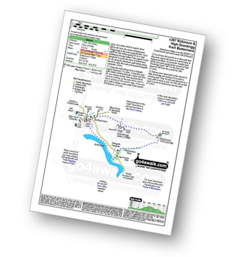
Route Summary:
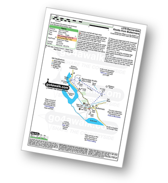
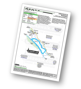
Buttermere - Dalegarth - Hassnesshow Beck - Goat Crag - Goat Gills - Robinson - Buttermere Moss - High Snockrigg - Buttermere
|
Vital Statistics:
| Length: | 8.25 miles (13 km) |
| Ascent: | 1,031ft (314m) |
| Time: | 4 hrs |
| Grade: |  |
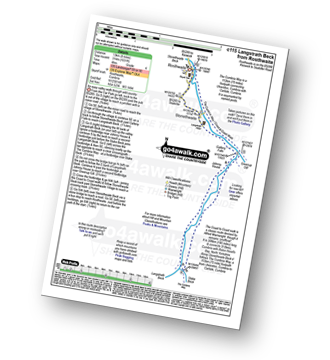
Route Summary:
Rosthwaite - Wainwright's Coast to Coast Walk - Stonethwaite - Stonethwaite Beck - Galleny Force - Langstrath Beck - The Cumbria Way - Greenup Gill - Stonethwaite - Rosthwaite
|
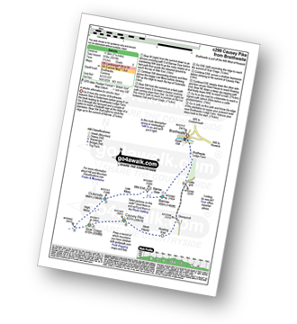
Vital Statistics:
| Length: | 5.5 miles (9 km) |
| Ascent: | 1,384ft (422m) |
| Time: | 3½ hrs |
| Grade: | |
Route Summary:
Seatoller - The Allerdale Ramble - Longthwaite - Rosthwaite - New Bridge - The River Derwent - The Cumbria Way - Castle Crag - Seatoller
|
Vital Statistics:
| Length: | 5 miles (8 km) |
| Ascent: | 1,533ft (467m) |
| Time: | 3½ hrs |
| Grade: | |
Route Summary:
Whinlatter Forest Park - Thwaitehill Knotts - Beckstone Plantation - Beckstone Gill - Barf - Lord's Seat (Whinlatter) - Whinlatter Forest Park
|
Vital Statistics:
| Length: | 3.75 miles (6 km) |
| Ascent: | 1,628ft (496m) |
| Time: | 3 hrs |
| Grade: | |
Route Summary:
Keswick - Derwent Water Launch - Nichol End Pier - Hawes End Pier - Newlands Valley - Woodford's Path - Cat Bells (Catbells) - Hawes End Pier - Derwent Water Launch - Keswick
|
Vital Statistics:
| Length: | 5 miles (8 km) |
| Ascent: | 649ft (198m) |
| Time: | 2.75hrs |
| Grade: |  |
Route Summary:
Hawes End - Gutherscale - Derwent Water - Skelgill Farm - Yewthwaite Gill - Little Town - Parrocks Gill - Goldscope Lead Mine - Newlands Beck - Low Snab Farm - Newlands Church - Newlands Valley - Rigg Beck - Rowling End Farm - Newlands Beck - Ghyll Bank - Skelgill Farm - Gutherscale - Hawes End
|
Vital Statistics:
| Length: | 3.25 miles (5 km) |
| Ascent: | 968ft (295m) |
| Time: | 2.25hrs |
| Grade: | |
|
Vital Statistics:
| Length: | 4.5 miles (7 km) |
| Ascent: | 630ft (192m) |
| Time: | 2.25hrs |
| Grade: | |
Route Summary:
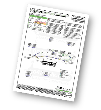
Cockermouth - Watch Hill (Cockermouth) - Hay - Setmurthy Plantation - Setmurthy Common (Watch Hill) - Peel Wood - Long Bottom - Greenlands - Cockermouth
|
Vital Statistics:
| Length: | 4.75 miles (7.5 km) |
| Ascent: | 485ft (148m) |
| Time: | 2 hrs |
| Grade: |  |
Route Summary:
Buttermere - Dalegarth - Hassnesshow Beck - Gatesgarth - Black Beck - Peggy's Bridge - Burtness Wood - Buttermere
|
Vital Statistics:
| Length: | 7.5 miles (12 km) |
| Ascent: | 262ft (80m) |
| Time: | 3 hrs |
| Grade: | |
Route Summary:
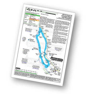
Buttermere - Great Wood - Wood House - Crummock Water - Hause Point - Rannerdale Bridge - Cinderdale Common - Lanthwaite Green - High Wood - Lanthwaite Wood - River Cocker - Park Beck - Iron Stone - Low Ling Crag - Scale Bridge - Buttermere
|
Vital Statistics:
| Length: | 9 miles (14 km) |
| Ascent: | 131ft (40m) |
| Time: | 3.25hrs |
| Grade: | |
Route Summary:
Keswick - The Cumbria Way - The Allerdale Ramble - Portinscale - Nichol End - Derwent Water - Hawes End - Brandlehow Point - Park Neb - Strutta Wood - Calfclose Bay - Stable Hills - Friar's Crag - Keswick
|
Vital Statistics:
| Length: | 2.5 miles (4 km) |
| Ascent: | 794ft (242m) |
| Time: | 2 hrs |
| Grade: | |
Route Summary:
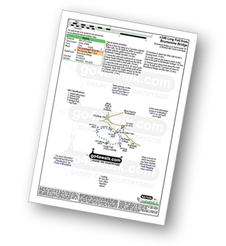
Brumstone Bridge - Eskin Farm - Corpse Road - Ling Fell (Wythop) - Burthwaite Cottage - Brumstone Bridge
|
Vital Statistics:
| Length: | 2.5 miles (4 km) |
| Ascent: | 748ft (228m) |
| Time: | 1.75hrs |
| Grade: | |
|
Vital Statistics:
| Length: | 4 miles (6.5 km) |
| Ascent: | 433ft (132m) |
| Time: | 2 hrs |
| Grade: | |
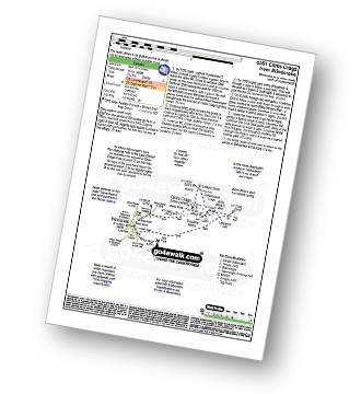
Route Summary:
Blindcrake - Clints Park - Clints Crags - Salkeld Close - Salkeldclose Crags - Thackray Wood - Willie White's Well - Ullerance Gill - Isle Park - Blindcrake
See this list of walks, routes & maps in:
Grade Order | Length Order | Time Order | Walk Number or Start Location Order
NB. To reverse (toggle) this order, click Grade Order again


