37 easy-to-follow circular walks in Shropshire
Thirty-seven easy-to-follow hand-crafted circular walks, routes & maps in Shropshire of all grades in Walk Grade Order
See this list of walks, routes & maps in:
Grade Order | Length Order | Time Order | Walk Number or Start Location Order
NB. To reverse (toggle) this order, click Grade Order again
   |
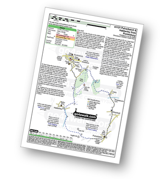
Vital Statistics:
| Length: | 3.75 miles (6 km) |
| Ascent: | 1,004ft (306m) |
| Time: | 2½ hrs |
| Grade: |  |
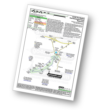
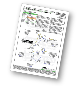
Route Summary:
Buckatree Farm Reservoir - Wrekin Cottage - The Shropshire Way - Hell Gate - Heaven Gate - The Wrekin - Little Hill - Needle's Eye - Wenlocks Wood - Buckatree Farm Reservoir
|
Vital Statistics:
| Length: | 6.5 miles (10.5 km) |
| Ascent: | 1,152ft (351m) |
| Time: | 3½ hrs |
| Grade: |  |
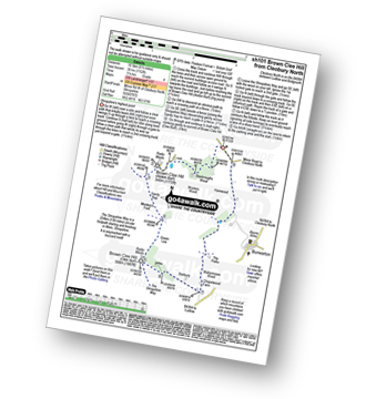
Route Summary:
Cleobury North - Stanbroughs Wood - Brown Clee Hill (Abdon Burf) - The Shropshire Way - Sandy Nap - Monkeys Fold - Green Lea - Brown Clee Hill (Clee Burf) - Chapelwod Farm - Wallermoore Wood - Harewood - Cleobury North
|
Vital Statistics:
| Length: | 8.75 miles (14 km) |
| Ascent: | 1,387ft (423m) |
| Time: | 4.75hrs |
| Grade: |  |
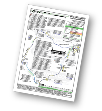
Route Summary:
Church Stretton - Town Brook - The Jack Mytton Way - The Long Mynd - Pole Bank (Long Mynd) - Midland Gliding Club - Minton Bach - Minton - Little Stretton - Chruch Stretton.
|
Vital Statistics:
| Length: | 10.25 miles (16.5 km) |
| Ascent: | 2,435ft (742m) |
| Time: | 6.25hrs |
| Grade: |  |
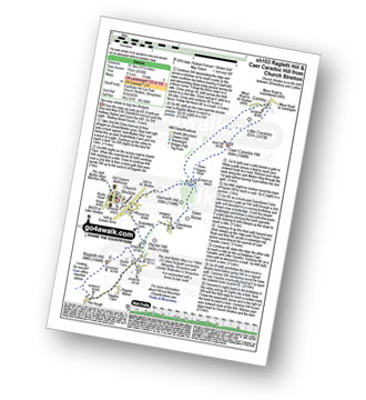
Route Summary:
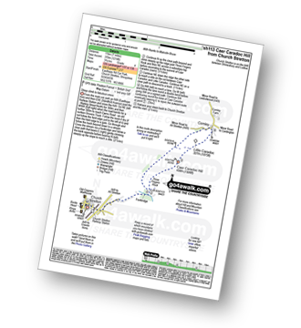
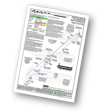
Church Stretton - The Jack Mytton Way - Snatchfield Farm - Clemcroft - Ragleth Hill - Ragdon Manor - Gaerstones Farm - Caer Caradoc Hill - Little Caradoc - Church Stretton
|
Vital Statistics:
| Length: | 6.5 miles (10.5 km) |
| Ascent: | 853ft (260m) |
| Time: | 3.25hrs |
| Grade: | |
Route Summary:
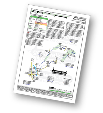
Craven Arms - River Onny - Halford - Ireland Cottage - Hills and Dales Hike - Lower Dinchope - Hanging Wood - Callowhill Plantation - Wenlock Edge - Callow Hill (Little Stretton) - Flounders Folly - Frizland Coppice - Moorwood Farm - Strefford Wood - Berrymill Wood - Halford - Craven Arms
|
Vital Statistics:
| Length: | 5.5 miles (9 km) |
| Ascent: | 295ft (90m) |
| Time: | 2½ hrs |
| Grade: |  |
Route Summary:
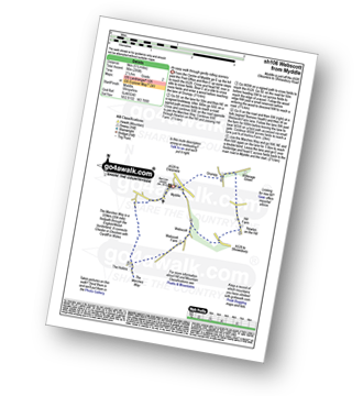
Myddle - Myddle Hill - Grumpy - Hill Farm - Newton on the Hill - Webscott - The Hollins - Myddle
|
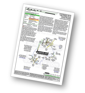
Vital Statistics:
| Length: | 5.25 miles (8.5 km) |
| Ascent: | 532ft (162m) |
| Time: | 2½ hrs |
| Grade: | |
Route Summary:
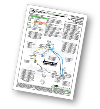
Eardington - Dinney Barn - The Jack Mytton Way - Chelmarsh Reservoir - Chelmarsh - Hampton - The Jack Mytton Way - The Severn Valley Railway - Hampton Loade - The Hampton Loade Ferry - The River Severn - The Severn Way - Eardington
|
Vital Statistics:
| Length: | 6.25 miles (10 km) |
| Ascent: | 295ft (90m) |
| Time: | 2½ hrs |
| Grade: | |
Route Summary:
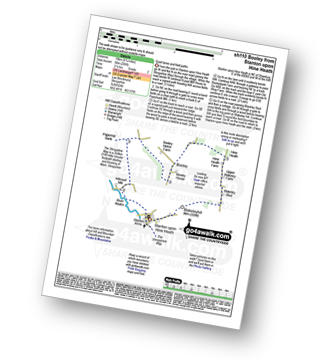
Stanton Upon Hine Heath - The Shropshire Way - River Roden - Harcourt Mill - Paperbank Mill - Hardcourt Farm - The Woodlands - Booley - Old Shop Farm - Quarry Coppice - Megan's Coppice - Hine Heath - Hine Heath Farm - Upper Blakeley Farm - Blakeley Stud - Blakeleyhill - Stanton Upon Hine Heath
|
Vital Statistics:
| Length: | 7 miles (11 km) |
| Ascent: | 1,214ft (370m) |
| Time: | 3.75hrs |
| Grade: | |
Route Summary:
Church Stretton - Three Fingers Rock - Caer Caradoc Hill - Little Caradoc - Comley - Church Stretton
|
Vital Statistics:
| Length: | 8.75 miles (14 km) |
| Ascent: | 578ft (176m) |
| Time: | 3.75hrs |
| Grade: | |
Route Summary:
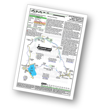
The Mere - Ellesmere - Crimps�Farm - Ellesmere Point - Welshampton - Hawthorn House - The Stocks - Brook House - Mill Wood - Old Coppice - Spout Wood - Sandy Hall - Haughton Farm - The Mere - Ellesmere.
|
Vital Statistics:
| Length: | 4 miles (6.5 km) |
| Ascent: | 1,011ft (308m) |
| Time: | 2½ hrs |
| Grade: | |
Route Summary:
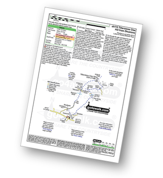
Dhustone - The Shropshire Way - Nine Spring Farm - Titterstone Incline - Titterstone Clee Hill - Hullabaloo House - Titterstone - Benson' Brook - Woodlands - Greenacres - Dhustone
|
Vital Statistics:
| Length: | 7 miles (11 km) |
| Ascent: | 880ft (268m) |
| Time: | 3½ hrs |
| Grade: | |

Route Summary:
Craven Arms - River Onny - Hills and Dales Hike - Stokesay Castle - Clapping Wicket - View Edge (Weo Edge) - Aldon - Stokesay Castle - River Onny - Craven Arms
|
Vital Statistics:
| Length: | 7.75 miles (12.5 km) |
| Ascent: | 1,355ft (413m) |
| Time: | 4.25hrs |
| Grade: | |
Route Summary:
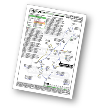
Stiperstones Car Park - Gatten Plantation - The Shropshire Way - Shepherd's Rock - Devil's Chair - Stiperstones (Manstone Rock) - Nipstone Rock - The Rock - Ridge - Cold Hill Farm - Stiperstones Car Park
|
Vital Statistics:
| Length: | 7.75 miles (12.5 km) |
| Ascent: | 1,083ft (330m) |
| Time: | 4 hrs |
| Grade: | |
Route Summary:
Pontesbury - Oaks Wood - The Marches Way - Oaks - Wrentnall - Pulverbatch - Habberley - Pontesbury
|
Vital Statistics:
| Length: | 5 miles (8 km) |
| Ascent: | 197ft (60m) |
| Time: | 2 hrs |
| Grade: |  |
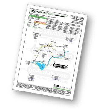
Route Summary:
Welshampton - Rowe Farm - Shropshire Union Canal (Llangollen Branch) - Cole Mere - Welshampton
|
Vital Statistics:
| Length: | 9.5 miles (15.5 km) |
| Ascent: | 1,132ft (345m) |
| Time: | 4.75hrs |
| Grade: | |
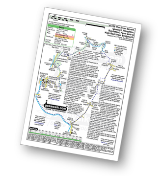
Route Summary:
Bridgnorth - The River Severn - Quatford - Stanmore Country Park - Hoccum - Roughton - Burcote House - River Worfe - Soudley Rocks - Rindleford - Batch House - Fenn Gate - Woodside - High Rock - Caves - The Hermitage - Hermitage Hill Coppice - Bridgnorth
|
Vital Statistics:
| Length: | 5.25 miles (8.5 km) |
| Ascent: | 945ft (288m) |
| Time: | 3 hrs |
| Grade: | |
Route Summary:
Church Stretton - The Jack Mytton Way - Snatchfield Farm - Clemcroft - Ragleth Hill - Ragdon Manor - Church Stretton
|
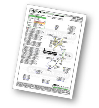
Vital Statistics:
| Length: | 9 miles (14.5 km) |
| Ascent: | 797ft (243m) |
| Time: | 4.25hrs |
| Grade: | |
Route Summary:
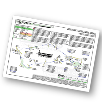
Corbet Wood - Grinshill - Clive - Grumpy - Myddle - The Marches Way - Webscott - Newton on the Hill - Yorton - Clive - Grinshill - The Shropshire Way - Corbet Wood - Grinshill
|
Vital Statistics:
| Length: | 8.5 miles (13.5 km) |
| Ascent: | 1,791ft (546m) |
| Time: | 5 hrs |
| Grade: | |
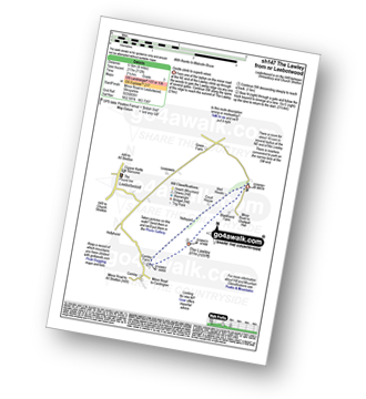
Route Summary:
Leebotwood - The Lawley - Comley - Caer Caradoc Hill - Three Fingers Rock - Comley - Leebotwood
|
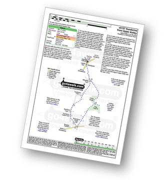
Vital Statistics:
| Length: | 3.25 miles (5 km) |
| Ascent: | 479ft (146m) |
| Time: | 1.75hrs |
| Grade: | |
Route Summary:
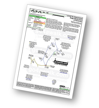
Stiperstones Car Park - Gatten Plantation - The Shropshire Way - Shepherd's Rock - Devil's Chair - Stiperstones (Manstone Rock) - Stiperstones Car Park
|
Vital Statistics:
| Length: | 9 miles (14.5 km) |
| Ascent: | 420ft (128m) |
| Time: | 3.75hrs |
| Grade: | |
Route Summary:
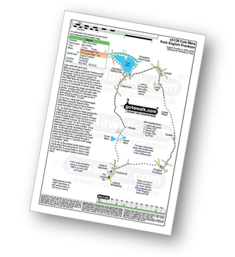
Cockshutt - English Frankton - Quaikin - Lyneal Wood - Lyneal Hall - River Roden - Lyneal - Cole Mere - Colemere - Whattal Farm - Whattal Moss - Seat Mere - Crose Mere - Lloyd's Wood - Crosemere House - Cockshutt,.
|
Vital Statistics:
| Length: | 5.25 miles (8.5 km) |
| Ascent: | 876ft (267m) |
| Time: | 3 hrs |
| Grade: | |
Route Summary:
Stiperstones Car Park - The Shropshire Way - Nipstone Rock - The Rock - Ridge - Cold Hill Farm - Stiperstones Car Park
|
Vital Statistics:
| Length: | 7.5 miles (12 km) |
| Ascent: | 420ft (128m) |
| Time: | 3.25hrs |
| Grade: | |
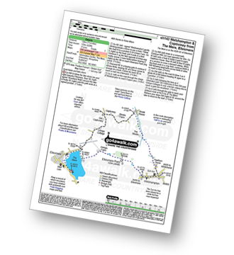
Route Summary:
The Mere - Ellesmere - Crimps Farm - Ellesmere Point - Welshampton - Hawthorn House - The Stocks - Brook House - Stocks Farm - Coptiviney - Old Coptiviney - Crimps Cottage - The Mere - Ellesmere.
|
Vital Statistics:
| Length: | 9 miles (14.5 km) |
| Ascent: | 1,004ft (306m) |
| Time: | 4½ hrs |
| Grade: | |
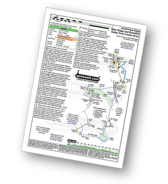
Route Summary:
Craven Arms - River Onny - Hills and Dales Hike - Stokesay Castle - Clapping Wicket - View Edge (Weo Edge) - Gorst Barn - Brandhill Gutter - Aldon Gutter - Aldon - Stokesay Castle - River Onny - Craven Arms
|
Vital Statistics:
| Length: | 4 miles (6.5 km) |
| Ascent: | 712ft (217m) |
| Time: | 2.25hrs |
| Grade: | |
|
Vital Statistics:
| Length: | 5 miles (8 km) |
| Ascent: | 542ft (165m) |
| Time: | 2½ hrs |
| Grade: | |
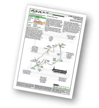
Route Summary:
Weston - Wixhill - Lee Brockhurst - The Shropshire Way - Weston Heath Coppice - Weston Heath - Weston
|
Vital Statistics:
| Length: | 5.75 miles (9 km) |
| Ascent: | 1,027ft (313m) |
| Time: | 3.25hrs |
| Grade: | |
Route Summary:
Church Stretton - The Jack Mytton Way - Snatchfield Farm - Clemcroft - Ragleth Hill - Little Stretton - Church Stretton
|
Vital Statistics:
| Length: | 5 miles (8 km) |
| Ascent: | 161ft (49m) |
| Time: | 2 hrs |
| Grade: | |
Route Summary:
Upper Astley - The Shropshire Way - Wheatley Farm - Sunderton Farm - Sundorne Farm - Sundorne Castle Farm - Shrewsbury Rugby Club - New Coppice - Colin's Rough - Wheatley Farm - Upper Astley
|
Vital Statistics:
| Length: | 6 miles (9.5 km) |
| Ascent: | 351ft (107m) |
| Time: | 2½ hrs |
| Grade: | |
Route Summary:
Grinshill - The Marches Way - Yorton Villa Farm - Yorton House Farm - Yorton Heath - Sansaw Heath - Sheepcotes - Sansaw Business Park - The Shropshire Way - Grinshill
|
Vital Statistics:
| Length: | 10.25 miles (16.5 km) |
| Ascent: | 1,526ft (465m) |
| Time: | 5.25hrs |
| Grade: | |
Route Summary:
Craven Arms - Ireland Cottage - Hills and Dales Hike - Lower Dinchope - Hanging Wood - Wenlock Edge - Callow Hill (Little Stretton) - Flounders Folly - Frizland Coppice - Westhope - Wenlock Edge - Alcaton Common - Strefford Wood - Halford - Craven Arms
|
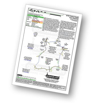
Vital Statistics:
| Length: | 5.25 miles (8.5 km) |
| Ascent: | 459ft (140m) |
| Time: | 2½ hrs |
| Grade: | |
|
Vital Statistics:
| Length: | 7.5 miles (12 km) |
| Ascent: | 361ft (110m) |
| Time: | 3 hrs |
| Grade: | |
Route Summary:
Upper Astley - The Shropshire Way - Wheatley Farm - Sunderton Farm - Sundorne Farm - Sundorne Castle Farm - The River Severn - Uffington - Haughmond Hill (Forest Commisison) - The Hollies - Haughmond Abbey - Abbey Wood - Haughmond Farm - New Coppice - Colins Rough - Wheatley Farm - Upper Astley
|
Vital Statistics:
| Length: | 6.25 miles (10 km) |
| Ascent: | 558ft (170m) |
| Time: | 2.75hrs |
| Grade: | |
Route Summary:
Corbet Wood - Clive - Witterage Green - Newton On The Hill - Yorton - Grinshill - Corbet Wood
|
Vital Statistics:
| Length: | 10 miles (16 km) |
| Ascent: | 722ft (220m) |
| Time: | 4.25hrs |
| Grade: | |
Route Summary:
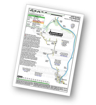
Bridgnorth - Lower Town - River Severn - The Severn Way - Apley Forge - Nordley - Astley Abbots - Cross Lane Head - High Town - Bridgnorth - Lower Town - Bridgnorth
|
Vital Statistics:
| Length: | 9.25 miles (14.5 km) |
| Ascent: | 321ft (98m) |
| Time: | 3.75hrs |
| Grade: | |
Route Summary:
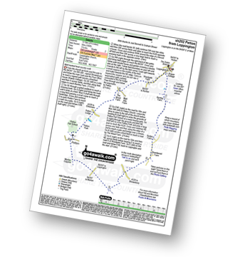
Loppington - Bentley Farm - Roden Farm - Brandwood Farm - Marton Coppice - Petton - Petton Hall - Petton Park - The Wood Farm - Woodgate Farm - Loppington
|
Vital Statistics:
| Length: | 4.75 miles (7.5 km) |
| Ascent: | 295ft (90m) |
| Time: | 2 hrs |
| Grade: | |
Route Summary:
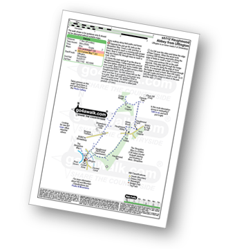
Uffington - Haughmond Hill (Forest Commisison) - The Hollies - Haughmond Abbey - Abbey Wood - Haughmond Farm - New Coppice - Haughmond Hill (Forest Commisison) - Uffington
|
Vital Statistics:
| Length: | 6.5 miles (10.5 km) |
| Ascent: | 241ft (104m) |
| Time: | 2.75hrs |
| Grade: | |
Route Summary:
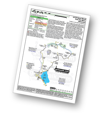
The Mere - Ellesmere - Crimps Cottage - Old Coptiviney - Coptiviney - Brook House - Mill Wood - Old Coppice - Spout Wood - Sandy Hall - Haughton Farm - The Mere - Ellesmere.
See this list of walks, routes & maps in:
Grade Order | Length Order | Time Order | Walk Number or Start Location Order
NB. To reverse (toggle) this order, click Grade Order again


