3 easy to follow walk route maps of all grades that include part of The St Oswald's Way
The St Oswald's Way is a 156km (97 miles) linear footpath connecting Holy Island (Lindisfarne) in Northumberland, England with Heavenfield (Hardrian's Wall) in Northumberland, England.
The St Oswald's Way is waymarked by named posts.
Not familiar with The St Oswald's Way?
See these 3 walks that include part of The St Oswald's Way on an interactive Google Map
   |
Vital Statistics:
| Length: | 4.5 miles (7 km) |
| Ascent: | 387ft (118m) |
| Time: | 2 hrs |
| Grade: |  |
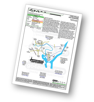
Route Summary:
Alnmouth - Beach - The St Oswald's Way - River Aln - Lesbury - Foxton Hall - Marden Rocks - Alnmouth Golf Club - Alnmouth
|
Vital Statistics:
| Length: | 5.25 miles (8.5 km) |
| Ascent: | 430ft (131m) |
| Time: | 2½ hrs |
| Grade: | |
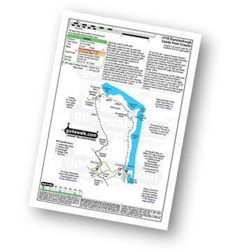
Route Summary:
Craster - Cushat Stiel - Queen Margaret's Cove - Dunstanburgh Castle - The St Oswald's Way - Embleton Bay - Dunstan Steads - Dunstan Square Farm - Proctors Spread - Dunstan - Craster Tower - Craster
|
Vital Statistics:
| Length: | 8.5 miles (13.5 km) |
| Ascent: | 1,450ft (442m) |
| Time: | 4.75hrs |
| Grade: |  |
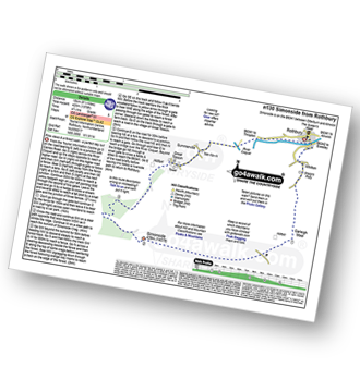
Route Summary:
Rothbury - The St Oswald's Way - Whitton - Whittondean Farm - Garleigh Moor - Lordenshaws Car Park - The Beacon - Dove Crag - Old stell Crag - Simonside - Bob Pyle's Studdie - Joe's Wood - Great Tosson - The Old Pumphouse - River Coquet - Anton's Letch - Rothbury
Not familiar with The St Oswald's Way?
See these 3 walks that include part of The St Oswald's Way on an interactive Google Map


