3 easy to follow walk route maps of all grades that include part of The St Oswald's Way
Three easy-to-follow walk route maps of all grades that include part of The St Oswald's Way in Walk Grade Order
The St Oswald's Way is a 156km (97 miles) linear footpath connecting Holy Island (Lindisfarne) in Northumberland, England with Heavenfield (Hardrian's Wall) in Northumberland, England.
The St Oswald's Way is waymarked by named posts.
Tap/mouse over a coloured circle (1-3 easy walks, 4-6 moderate walks, 7-9 hard walks) and click to select.
Scroll down the list of walks below & click on each walk title (in blue) to locate it on the map above.
   |
Vital Statistics:
| Length: | 5.25 miles (8.5 km) |
| Ascent: | 430ft (131m) |
| Time: | 2½ hrs |
| Grade: |  |
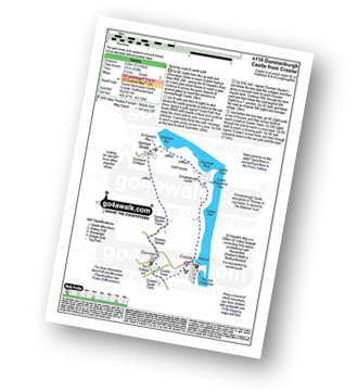
Route Summary:
Craster - Cushat Stiel - Queen Margaret's Cove - Dunstanburgh Castle - The St Oswald's Way - Embleton Bay - Dunstan Steads - Dunstan Square Farm - Proctors Spread - Dunstan - Craster Tower - Craster
|
Vital Statistics:
| Length: | 8.5 miles (13.5 km) |
| Ascent: | 1,450ft (442m) |
| Time: | 4.75hrs |
| Grade: |  |
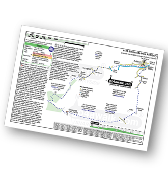
Route Summary:
Rothbury - The St Oswald's Way - Whitton - Whittondean Farm - Garleigh Moor - Lordenshaws Car Park - The Beacon - Dove Crag - Old stell Crag - Simonside - Bob Pyle's Studdie - Joe's Wood - Great Tosson - The Old Pumphouse - River Coquet - Anton's Letch - Rothbury
|
Vital Statistics:
| Length: | 4.5 miles (7 km) |
| Ascent: | 387ft (118m) |
| Time: | 2 hrs |
| Grade: | |
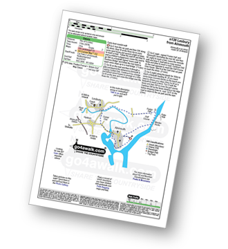
Route Summary:
Alnmouth - Beach - The St Oswald's Way - River Aln - Lesbury - Foxton Hall - Marden Rocks - Alnmouth Golf Club - Alnmouth


