2 easy to follow walk route maps of all grades that include part of The Oxfordshire Way
Two easy-to-follow walk route maps of all grades that include part of The Oxfordshire Way in Walk Grade Order
The Oxfordshire Way is a 104km (65 miles) linear footpath connecting Bourton-on-the-Water in Gloucestershire, England with Henley-on-Thames in Oxfordshire, England.
The Oxfordshire Way is waymarked by the letters OW.
Tap/mouse over a coloured circle (1-3 easy walks, 4-6 moderate walks, 7-9 hard walks) and click to select.
Scroll down the list of walks below & click on each walk title (in blue) to locate it on the map above.
   |
Vital Statistics:
| Length: | 6.5 miles (10.5 km) |
| Ascent: | 272ft (83m) |
| Time: | 2.75hrs |
| Grade: |  |
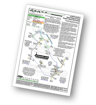
Route Summary:
Shipton Under Wychwood - Milton Under Wychwood - Grange Farm - Home Farm - Foxholes Nature Reserve - The Oxfordshire Way - Bruern Abbey - Shipton Under Wychwood
|
Vital Statistics:
| Length: | 8.75 miles (14 km) |
| Ascent: | 574ft (175m) |
| Time: | 3.75hrs |
| Grade: |  |
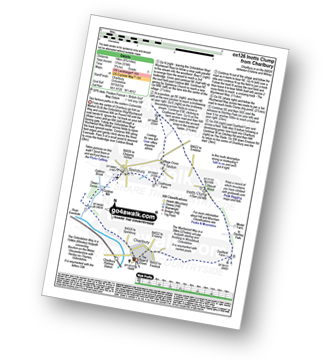
Route Summary:
Charlbury - The Oxfordshire Way - Dean Grove - Coldron Mill - Spelsbury - Taston - Taston Village Cross - The Wychwood Way - Inotts Clump - Shilcott Wood - Ditchley Park - Charlbury


