1 easy to follow walk route map that includes part of The Cotswold Way
One easy-to-follow walk route map of all grades that includes part of The Cotswold Way in Walk Grade Order
The Cotswold Way is a 163km (101 miles) linear footpath connecting Chipping Campden in Gloucestershire, England with Bath in Somerset, England.
The Cotswold Way is waymarked by a National Trail Acorn.
Tap/mouse over a coloured circle (1-3 easy walks, 4-6 moderate walks, 7-9 hard walks) and click to select.
Scroll down the list of walks below & click on each walk title (in blue) to locate it on the map above.
   |
Vital Statistics:
| Length: | 8.5 miles (13.5 km) |
| Ascent: | 951ft (290m) |
| Time: | 4 hrs |
| Grade: |  |
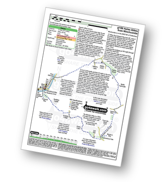
Route Summary:
Winchcombe - River Isbourne - The Cotswold Way - Salter's Lane - Hailes Abbey - North Farmcote - Lynes Barn - Campden Lane (Track) - Deadmanbury Gate - Wardens' Way - Salt Way - The Warren - Parks Farm - Sudeley Lodge - Sudeley Castle - Winchcombe


