2 easy to follow walk route maps of all grades that include part of The Cleveland Way
Two easy-to-follow walk route maps of all grades that include part of The Cleveland Way in Walk Grade Order
The Cleveland Way is a 177km (110 miles) linear footpath connecting Helmsley in North Yorkshire, England with Filey Brigg in North Yorkshire, England.
The Cleveland Way is waymarked by a National Trail Acorn.
Tap/mouse over a coloured circle (1-3 easy walks, 4-6 moderate walks, 7-9 hard walks) and click to select.
Scroll down the list of walks below & click on each walk title (in blue) to locate it on the map above.
   |
Vital Statistics:
| Length: | 6.25 miles (10 km) |
| Ascent: | 1,355ft (413m) |
| Time: | 3.75hrs |
| Grade: |  |
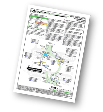
Route Summary:
Kilburn White Horse - Hoodhill Feld Plantation - Hood Hill Plantation - Hood Grange - Kennycow - High Cleavers Farm - Gormire Rigg - Gormire Lake - Southwoods Lodge - Garbutt Wood - The Cleveland Way - Whitestone Cliff - White Mare Crag - Great Relief Pot - Cliff Plantation - Sutton Brow - Sutton Bank - Knowlson's Drop - Roulston Scar - Ivy Scar - Kilburn White Horse
|
Vital Statistics:
| Length: | 8.75 miles (14 km) |
| Ascent: | 1,398ft (426m) |
| Time: | 4½ hrs |
| Grade: |  |
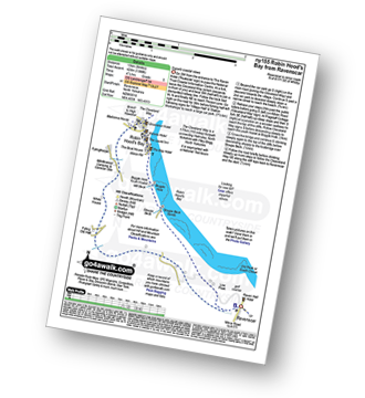
Route Summary:
Robin Hood's Bay - The Cleveland Way - Cowfield Hill - Boggle Hole - Stoupe Beck - Stoupe Bank Farm - Stoupebrow Cottage Farm - Ravenscar - Dismantled Railway - Stoupe Brow Farm - Home Farm - Brownside Farm - Howdale Wood - Alison Head Wood - Fyling Old Hall Farm - White House - Fylingthorpe - Robin Hood's Bay


