1 easy to follow walk route map that includes part of The Cistercian Way
One easy-to-follow walk route map of all grades that includes part of The Cistercian Way in Walk Grade Order
The Cistercian Way is a 53km (33 miles) linear footpath connecting Grange-over-Sands in Cumbria, England with Roa Island in Cumbria, England.
The Cistercian Way is waymarked by a monk motif.
Tap/mouse over a coloured circle (1-3 easy walks, 4-6 moderate walks, 7-9 hard walks) and click to select.
Scroll down the list of walks below & click on each walk title (in blue) to locate it on the map above.
   |
Vital Statistics:
| Length: | 11 miles (17.5 km) |
| Ascent: | 804ft (245m) |
| Time: | 4.75hrs |
| Grade: |  |
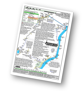
Route Summary:
Ulverston - Ulverston Canal - Canal Foot - The Cumbria Coastal Way - Hammerside Point - Salt Cotes - Sandhall - Beach Wood - Morecambe Bay - Conishead Bank - Wadhead Scar - Bardsea - Ulverston Sands - Sea Wood - Birkrigg Stone Circle - Birkrigg Common - Great Unswick - Urswick Tarn - The Cistercian Way - Croftlands - Swarthmoor Hall - Kilner Park - Levy Beck - Ulverston


