The Mountains, Peaks, Tops and Hills in Dartmoor, Devon with all the tops you have already bagged in first & then the ones you are yet to climb second.
Dartmoor National Park is located in South West England, wholly within the county of Devon.
If you include the Marilyns, the Bridgets (Hills) and all the Mountains, Tops, Peaks and Hills with a Trig Point on them there are 59 tops to climb, bag & conquer and the highest point is High Willhays at 622m (2,041ft).
To see these Mountains, Peaks, Tops and Hills displayed in different ways - see the options in the left-hand column and towards the bottom of this page.
![]() Your Personal Bagging Record for Dartmoor
Your Personal Bagging Record for Dartmoor
LOG ON and RELOAD this page to show which Mountains, Peaks, Tops and Hills you have already climbed, bagged & conquered [. . . more details]
Scroll down this list of mountains, peaks, tops & hills below and tap/click on each name (in blue) to locate it on the map above.
See this list in: Alphabetical Order | Height Order‡
To reverse the order select the link again.
Mountain, Peak, Top or Hill already bagged:
Bagged
Top yet to be climbed, bagged & conquered:
Bagged

![]()
1. Holne Chase
198m (649ft)
Bridget
See more details, photos, trip reports and easy-to-follow walks up Holne Chase
![]()
2. Hanger Down
233m (764ft)
Bridget
See more details, photos, trip reports and easy-to-follow walks up Hanger Down
![]()
3. Prestonbury Common
249m (817ft)
Bridget
See more details, photos, trip reports and easy-to-follow walks up Prestonbury Common
![]()
4. Shaptor Rock (Shaptor Down)
268m (879ft)
Bridget
See more details, photos, trip reports and easy-to-follow walks up Shaptor Rock (Shaptor Down)
![]()
5. Wigford Down
273m (895ft)
Bridget
See more details, photos, trip reports and easy-to-follow walks up Wigford Down

![]()
6. Brent Hill (Beara Common)
311m (1020ft)
Bridget and Trig Point
See more details, photos, trip reports and easy-to-follow walks up Brent Hill (Beara Common)
![]()
7. Heltor Rock
312m (1023ft)
Bridget
See more details, photos, trip reports and easy-to-follow walks up Heltor Rock
![]()
8. Laployd Hill
323m (1060ft)
Bridget
See more details, photos, trip reports and easy-to-follow walks up Laployd Hill
![]()
9. Auswell Rocks
325m (1066ft)
Bridget
See more details, photos, trip reports and easy-to-follow walks up Auswell Rocks
![]()
10. Hunter's Tor
326m (1069ft)
Bridget
See more details, photos, trip reports and easy-to-follow walks up Hunter's Tor
![]()
11. Natterdon Common
333m (1092ft)
Bridget
See more details, photos, trip reports and easy-to-follow walks up Natterdon Common
![]()
12. Brent Tor
334m (1096ft)
Bridget and Trig Point
See more details, photos, trip reports and easy-to-follow walks up Brent Tor
![]()
13. Cranbook Castle (Uppacott Down)
337m (1106ft)
Bridget
See more details, photos, trip reports and easy-to-follow walks up Cranbook Castle (Uppacott Down)
![]()
14. Gutter Tor (Ringmoor Down)
350m (1148ft)
Bridget and Trig Point
See more details, photos, trip reports and easy-to-follow walks up Gutter Tor (Ringmoor Down)
![]()
15. Butterdon Down
351m (1151ft)
Bridget
See more details, photos, trip reports and easy-to-follow walks up Butterdon Down
![]()
16. Gibbet Hill (Dartmoor)
353m (1158ft)
Bridget and Trig Point
See more details, photos, trip reports and easy-to-follow walks up Gibbet Hill (Dartmoor)
![]()
17. Pepperdon Down
353m (1158ft)
Bridget
See more details, photos, trip reports and easy-to-follow walks up Pepperdon Down
![]()
18. Blackingstone Rock
355m (1165ft)
Bridget
See more details, photos, trip reports and easy-to-follow walks up Blackingstone Rock
![]()
19. Mardon Down
356m (1168ft)
Bridget
See more details, photos, trip reports and easy-to-follow walks up Mardon Down
![]()
20. Butterdon Hill
365m (1197ft)
Bridget and Trig Point
See more details, photos, trip reports and easy-to-follow walks up Butterdon Hill
![]()
21. Sheeps Tor (Yellowmead Down)
369m (1211ft)
Bridget
See more details, photos, trip reports and easy-to-follow walks up Sheeps Tor (Yellowmead Down)
![]()
22. Ugborough Beacon
378m (1240ft)
Bridget
See more details, photos, trip reports and easy-to-follow walks up Ugborough Beacon
![]()
23. Riddon Ridge
380m (1247ft)
Bridget
See more details, photos, trip reports and easy-to-follow walks up Riddon Ridge
![]()
24. Sharp Tor
380m (1247ft)
Bridget
See more details, photos, trip reports and easy-to-follow walks up Sharp Tor
![]()
25. Leedon Tor
389m (1276ft)
Bridget
See more details, photos, trip reports and easy-to-follow walks up Leedon Tor
![]()
26. Meldon Hill (Dartmoor)
390m (1279ft)
Bridget and Trig Point
See more details, photos, trip reports and easy-to-follow walks up Meldon Hill (Dartmoor)
![]()
27. Hayne Down (Bowerman's Nose)
391m (1283ft)
Bridget
See more details, photos, trip reports and easy-to-follow walks up Hayne Down (Bowerman's Nose)
![]()
28. Gripper's Hill
398m (1306ft)
Bridget
See more details, photos, trip reports and easy-to-follow walks up Gripper's Hill
![]()
29. Sharpitor (Peek Hill)
401m (1316ft)
Bridget
See more details, photos, trip reports and easy-to-follow walks up Sharpitor (Peek Hill)
![]()
30. Black Hill (Dartmoor)
412m (1352ft)
Bridget
See more details, photos, trip reports and easy-to-follow walks up Black Hill (Dartmoor)
![]()
31. Hound Tor (Bonehill Down)
414m (1358ft)
Bridget
See more details, photos, trip reports and easy-to-follow walks up Hound Tor (Bonehill Down)
![]()
32. Stalldown Barrow
415m (1362ft)
Bridget
See more details, photos, trip reports and easy-to-follow walks up Stalldown Barrow
![]()
33. Top Tor
432m (1417ft)
Bridget
See more details, photos, trip reports and easy-to-follow walks up Top Tor
![]()
34. Corndon Tor
434m (1424ft)
Bridget
See more details, photos, trip reports and easy-to-follow walks up Corndon Tor
![]()
35. Kestor Rock (Changford Common)
437m (1434ft)
Bridget
See more details, photos, trip reports and easy-to-follow walks up Kestor Rock (Changford Common)
![]()
36. Easdon Tor
439m (1440ft)
Bridget and Trig Point
See more details, photos, trip reports and easy-to-follow walks up Easdon Tor
![]()
37. Sourton Tors
440m (1444ft)
Bridget and Trig Point
See more details, photos, trip reports and easy-to-follow walks up Sourton Tors
![]()
38. Cox Tor
442m (1450ft)
Bridget and Trig Point
See more details, photos, trip reports and easy-to-follow walks up Cox Tor
![]()
39. Bellever Tor
443m (1453ft)
Bridget and Trig Point
See more details, photos, trip reports and easy-to-follow walks up Bellever Tor
![]()
40. South Hessary Tor
450m (1476ft)
Bridget
See more details, photos, trip reports and easy-to-follow walks up South Hessary Tor
![]()
41. Chinkwell Tor
452m (1483ft)
Bridget
See more details, photos, trip reports and easy-to-follow walks up Chinkwell Tor
![]()
42. Roos Tor
454m (1490ft)
Bridget
See more details, photos, trip reports and easy-to-follow walks up Roos Tor
![]()
43. Great Staple Tor
455m (1493ft)
Bridget
See more details, photos, trip reports and easy-to-follow walks up Great Staple Tor
![]()
44. Haytor Rocks
457m (1499ft)
Bridget
See more details, photos, trip reports and easy-to-follow walks up Haytor Rocks
![]()
45. Three Barrows (Ugborough Moor)
464m (1522ft)
Bridget and Trig Point
See more details, photos, trip reports and easy-to-follow walks up Three Barrows (Ugborough Moor)
![]()
46. White Tor
468m (1535ft)
Bridget
See more details, photos, trip reports and easy-to-follow walks up White Tor
![]()
47. Rippon Tor
473m (1552ft)
Bridget and Trig Point
See more details, photos, trip reports and easy-to-follow walks up Rippon Tor
![]()
48. Belstone Tor
479m (1572ft)
Bridget
See more details, photos, trip reports and easy-to-follow walks up Belstone Tor
![]()
49. Quickbeam Hill
481m (1578ft)
Bridget
See more details, photos, trip reports and easy-to-follow walks up Quickbeam Hill
![]()
50. Lee Moor (Penn Moor)
492m (1614ft)
Bridget and Trig Point
See more details, photos, trip reports and easy-to-follow walks up Lee Moor (Penn Moor)

![]()
51. Ryder's Hill
515m (1690ft)
Trig Point
See more details, photos, trip reports and easy-to-follow walks up Ryder's Hill
![]()
52. North Hessary Tor
517m (1696ft)
Trig Point
See more details, photos, trip reports and easy-to-follow walks up North Hessary Tor
![]()
53. Hameldown Tor (Hamel Down)
532m (1746ft)
Trig Point
See more details, photos, trip reports and easy-to-follow walks up Hameldown Tor (Hamel Down)
![]()
54. Sittaford Tor
538m (1765ft)
Bridget
See more details, photos, trip reports and easy-to-follow walks up Sittaford Tor
![]()
55. Cosdon Hill (Cawsand Hill)
551m (1808ft)
Trig Point
See more details, photos, trip reports and easy-to-follow walks up Cosdon Hill (Cawsand Hill)
![]()
56. Great Links Tor
587m (1926ft)
Trig Point
See more details, photos, trip reports and easy-to-follow walks up Great Links Tor
![]()
57. Cut Hill
603m (1979ft)
Trig Point
See more details, photos, trip reports and easy-to-follow walks up Cut Hill
![]()
58. Yes Tor
619m (2031ft)
Trig Point
See more details, photos, trip reports and easy-to-follow walks up Yes Tor

![]()
59. High Willhays
622m (2041ft)
Marilyn
See more details, photos, trip reports and easy-to-follow walks up High Willhays
![]() Your Personal Bagging Record for Dartmoor
Your Personal Bagging Record for Dartmoor
LOG ON and RELOAD this page to show which Mountains, Peaks, Tops and Hills you have already climbed, bagged & conquered [. . . more details]
View these 59 Mountains, Peaks, Tops and Hills:
- On a Downloadable PDF you can Print or Save to your Phone#
- On an Interactive Google Map (loads faster)
- On an Interactive Google Map with a list of tops below it.
(makes it easier to locate a particular top) - On a Detailed List in:
Alphabetical Order | Height Order - On one page with 'yet-to-be-bagged' listed 1st & then 'already-bagged' tops listed 2nd in:
Alphabetical Order | Height Order - On one page with 'already-bagged' tops listed 1st & then 'yet-to-be-bagged' tops listed 2nd in:
Alphabetical Order | Height Order
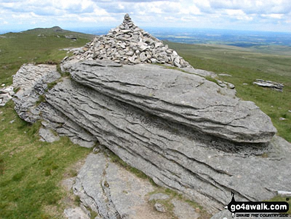 The summit of High Willhays in Dartmoor
Photo: David Rodgers
# Whether you print a copy or download it to your phone, this Peak Baggers' Map will prove incredibly useful if you want to know what's what when you are up in the mountains and cannot get a phone signal.
Is there a Mountain, Peak, Top or Hill missing from the above google map or list?


