UK Postcode CA18 - The 30 nearest easy-to-follow, circular walk route maps to you
The thirty nearest easy-to-follow, circular walk route maps to you in UK Postcode CA18 in Walk Grade Order
The UK cities, towns and villages in Cumbria, England that have CA18 in their UK Postcode include:
• Broad Oak • Ravenglass • Woodend •
Not familiar with the area around CA18?
See these 30 nearest walks to UK Postcode CA18 on a google map
   |
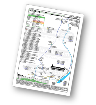
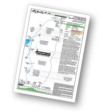
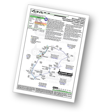
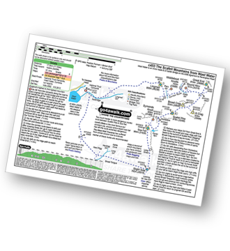
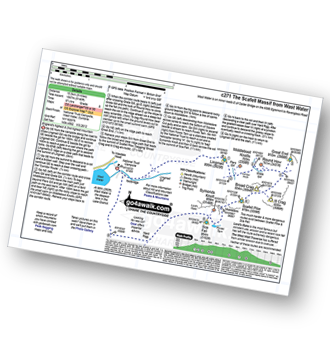
Vital Statistics:
| Length: | 10.25 miles (16.5 km) |
| Ascent: | 2,198ft (670m) |
| Time: | 6 hrs |
| Grade: |  |
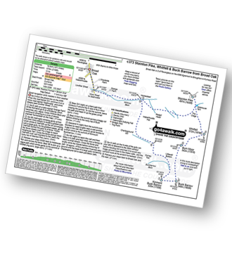
Route Summary:
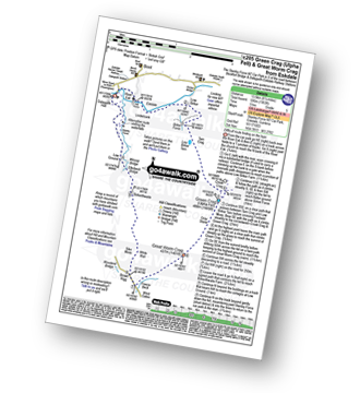
Broad Oak - Whitrow Beck - Waberthwaite Fell - Rowantree Falls - Stainton Pike - Whitfell (Whit Fell) - Burn Moor - Buck Barrow - Kinmont Buck Barrow - Whitrow Beck - Broad Oak
|
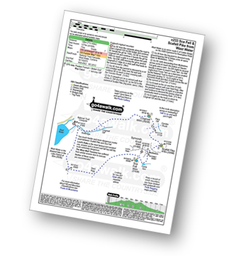
Vital Statistics:
| Length: | 8.75 miles (14 km) |
| Ascent: | 2,347ft (715m) |
| Time: | 5½ hrs |
| Grade: | |
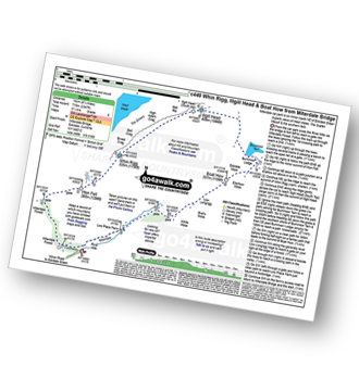
Route Summary:
Miterdale Bridge - Porterthwaite - Miterdale Forest - Irton Fell - Greathall Gill - Whin Rigg - Illgill Head - Burnmoor Tarn - Burnmoor Lodge - Eskdale Moor - Ellerhow Moss - Boat How - Low Longrigg - River Mite - Low Place Farm - Miterdale Bridge
|
Vital Statistics:
| Length: | 6.25 miles (10 km) |
| Ascent: | 1,611ft (491m) |
| Time: | 4 hrs |
| Grade: |  |
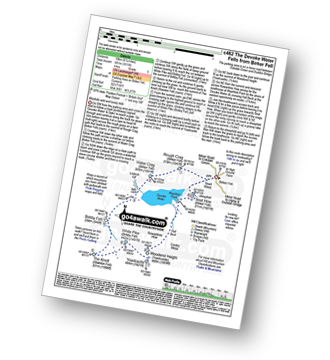
Route Summary:
Birker Fell - Tewit Moss - Rough Crag (Birker Fell) - Water Crag (Birker Fell) - Linbeck Gill - Birkby Fell - The Knott (Stainton Fell) - White Pike (Birkby Fell) - Yoadcastle - Woodend Height (Yoadcastle) - Cockly Moss - Rowantree How - Devoke Water - Washfold Point - Seat How (Birker Fell) - Tewit Moss - Birker Fell
|
Vital Statistics:
| Length: | 11 miles (17.5 km) |
| Ascent: | 1,418ft (432m) |
| Time: | 5½ hrs |
| Grade: | |
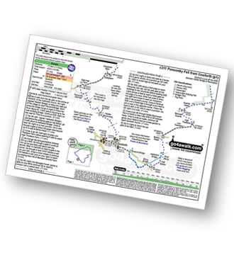
Route Summary:
Gosforth - Rowend Bridge - River Bleng - Bleng Bridge - Hall Bolton - Bolton Head - Low Thistleton Farm - High Thistleton Farm - Guards Head Farm - Hollow Moor - Brown Edge - Blengdale Forest - River Bleng - Scalderskew Beck - Ponsonby Fell - Scargreen Farm - Gidd Hall Farm - Ponsonby Old Hall - Middle Boonwood - Gosforth
|
Vital Statistics:
| Length: | 8.5 miles (13.5 km) |
| Ascent: | 1,953ft (595m) |
| Time: | 5 hrs |
| Grade: | |
Route Summary:
Stanley Force NT Car Park - Eskdale - Boot - River Esk - Low Birker - Crook Crag - Green Crag (Ulpha Fell) - Great Worm Crag - Brown Rigg - Sike Moss - Birkerthwaite - Low Ground Cottages - Stanley Force - River Esk - Stanley Force NT Car Park - Eskdale
|
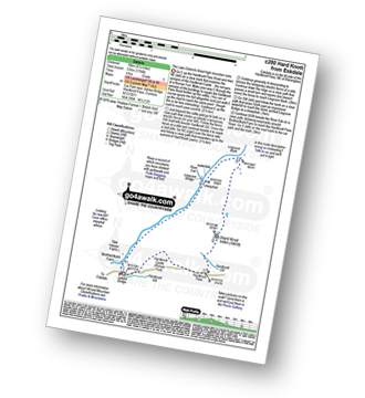
Vital Statistics:
| Length: | 6.25 miles (10 km) |
| Ascent: | 601ft (183m) |
| Time: | 3 hrs |
| Grade: |  |
Route Summary:
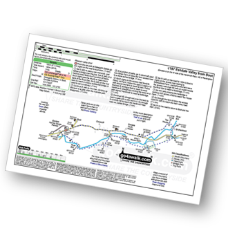
Eskdale - Boot - Dalegarth Station - River Esk - Doctor Bridge - Jubilee Bridge - Hardknott Pass - Brotherilkeld - Taw House Farm - Boot - Eskdale
|
Vital Statistics:
| Length: | 12.25 miles (19.5 km) |
| Ascent: | 3,568ft (1,087m) |
| Time: | 8 hrs |
| Grade: |  |
Route Summary:
Eskdale - The Woolpack Inn - Doctor Bridge - Low Birker - Birker Force - Low Birker Tarn - Green Crag (Ulpha Fell) - Crook Crag - Harter Fell (Eskdale) - Dunnerdale Forest - Hardknott Pass - Hardknott Gill - Hard Knott - Yew Bank - Lingcove Beck - Lingcove Bridge - Great Moss - Brotherilkeld - Taw House Farm - Wha House Farm - The River Esk - The Woolpack Inn - Eskdale
|
Vital Statistics:
| Length: | 11.25 miles (18 km) |
| Ascent: | 5,100ft (1,554m) |
| Time: | 9.25hrs |
| Grade: | |
Route Summary:
Greendale Farm - Middle Fell (Wasdale) - Seatallan - Pots of Ashness - Gowder Crag - Haycock - Great Scoat Fell - Steeple - Scoat Fell (Little Scoat Fell) - Red Pike (Wasdale) - Dore Head - Yewbarrow (North Top) - Yewbarrow - Bell Rib - Dropping Crag - Overbeck Bridge - Wast Water - Greendale Farm
|
Vital Statistics:
| Length: | 9.75 miles (15.5 km) |
| Ascent: | 3,236ft (986m) |
| Time: | 6.75hrs |
| Grade: |  |
Route Summary:
Greendale Farm - Gill Farm - Buckbarrow - Seatallan - Pots of Ashness - Gowder Crag - Haycock - Little Lad Crag - Nether Beck - Wast Water - Wasdale - Greendale Farm
|
Vital Statistics:
| Length: | 6 miles (9.5 km) |
| Ascent: | 2,504ft (763m) |
| Time: | 4.75hrs |
| Grade: | |
Route Summary:
Greendale Farm - Gill Farm - Gill Beck - Buckbarrow - Glade How - Cat Bields - Nether Wasdale Common - Seatallan - Pots of Ashness - Windscale Hows - Middle Fell (Wasdale) - Greendale Gill - Greendale Farm
|
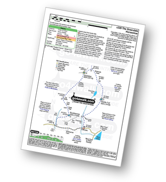
Vital Statistics:
| Length: | 14 miles (22.5 km) |
| Ascent: | 6,009ft (1,832m) |
| Time: | 9 hrs |
| Grade: |  |
Route Summary:
Eskdale - Wha House Farm - Hare Crag - Quagrigg Moss - Slight Side - Sca Fell - Symonds Knott - Mickledore - Scafell Pike - Broad Crag - Ill Crag - Great End - Esk Hause - Esk Pike - Ore Gap - Bow Fell (Bowfell) (North Top) - Bow Fell (Bowfell) - Bowfell Buttress - Cambridge Crag - Flat Crag - Climbers' Traverse (optional) - Three Tarns - Great Moss - Brotherikeld - Eskdale
|
Vital Statistics:
| Length: | 10 miles (16 km) |
| Ascent: | 3,428ft (1,045m) |
| Time: | 7 hrs |
| Grade: | |
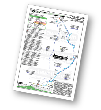
Route Summary:
Eskdale - Wha House Farm - Hare Crag - Quagrigg Moss - Slight Side - Sca Fell - Symonds Knott - Foxes Tarn - Cam Spout Crag - River Esk - Great Moss - Lingcove Bridge - Brotherilkeld - Hardknott Pass - Eskdale
|
Vital Statistics:
| Length: | 10 miles (16 km) |
| Ascent: | 3,401ft (1,037m) |
| Time: | 7 hrs |
| Grade: | |
Route Summary:
Eskdale - Wha House Farm - Hare Crag - Goat Crag - Dawsonground Crags - Cat Crag - Quagrigg Moss - Slight Side - Sca Fell - Symonds Knott - Hard Rigg - Burnmoor Tarn - Eel Tarn - Christcliff - Wha House Farm - Eskdale
|
Vital Statistics:
| Length: | 13.75 miles (22 km) |
| Ascent: | 4,982ft (1,519m) |
| Time: | 10 hrs |
| Grade: | |

Route Summary:
Eskdale - Wha House Farm - Hare Crag - Quagrigg Moss - Slight Side - Sca Fell - Symonds Knott - Scafell Pike - Broad Crag - Ill Crag - Great End - Esk Hause - Lingcove Bridge - Great Moss - Eskdale
|
Vital Statistics:
| Length: | 4.5 miles (7 km) |
| Ascent: | 1,559ft (475m) |
| Time: | 3.25hrs |
| Grade: |  |
Route Summary:
Beckside Farm - Whitecombe Beck - Whitcombe Screes - Stoupdale Head - White Combe - White Hall Knott - Whitecombe Beck - Beckside Farm
Not familiar with the area around CA18?
See these 30 nearest walks to UK Postcode CA18 on a google map
|
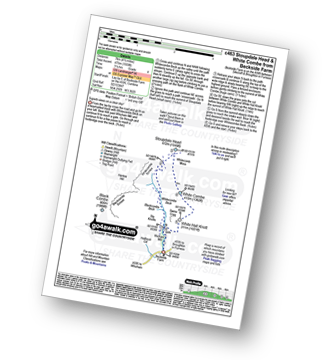
Vital Statistics:
| Length: | 6.25 miles (10 km) |
| Ascent: | 1,756ft (535m) |
| Time: | 4 hrs |
| Grade: | |
Route Summary:
Eskdale - Jubilee Bridge - Hardknott Pass - Hardknott Castle. (Roman Fort) - Hardknott Pass - Hard Knott - Yew Bank - Lingcove Beck - Lingcove Bridge - Great Moss - River Esk - Jubilee Bridge - Eskdale
|
Vital Statistics:
| Length: | 5 miles (8 km) |
| Ascent: | 2,002ft (610m) |
| Time: | 4 hrs |
| Grade: | |
Route Summary:
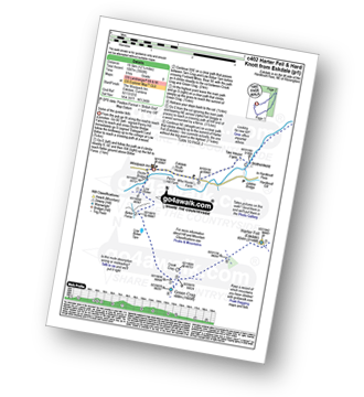
Eskdale - Jubilee Bridge - Eskdale - Dobknott Gill - Spothow Gill - Harter Fell (Eskdale) - Dunnerdale Forest - Hardknott Pass - Hardknott Castle (Roman Fort) - Jubilee Bridge - Eskdale
|
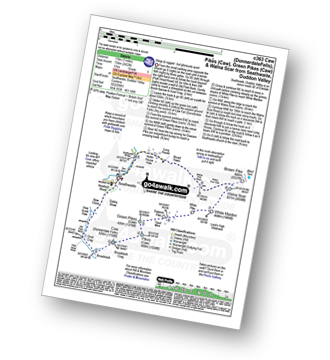
Vital Statistics:
| Length: | 5.5 miles (9 km) |
| Ascent: | 1,706ft (520m) |
| Time: | 3.75hrs |
| Grade: | |
Route Summary:
Seathwaite (Duddon Valley) - Newfield Wood - Dobby Shaw - New Close - How Scale Haw - Old Park Beck - Broadslack - Caw (Dunnerdale Fells) - Pikes (Caw) - Green Pikes (Caw) - Dawson Pike - Walna Scar Road - Broad Haws - Hollin House Haw - Tarn Beck - Seathwaite (Duddon Valley)
|
Vital Statistics:
| Length: | 7 miles (11 km) |
| Ascent: | 2,422ft (738m) |
| Time: | 5 hrs |
| Grade: | |
Route Summary:
Seathwaite (Duddon Valley) - Newfield Wood - Dobby Shaw - New Close - How Scale Haw - Old Park Beck - Broadslack - Caw (Dunnerdale Fells) - Pikes (Caw) - Green Pikes (Caw) - Dawson Pike - White Pike - White Maiden - Walna Scar - Walna Scar Road - Broad Haws - Hollin House Haw - Tarn Beck - Seathwaite (Duddon Valley)
|
Vital Statistics:
| Length: | 6.5 miles (10.5 km) |
| Ascent: | 1,453ft (443m) |
| Time: | 4 hrs |
| Grade: | |
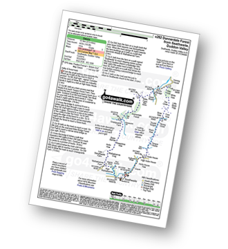
Route Summary:
Seathwaite (Duddon Valley) - Hollin House Haw - Tarn Beck - Worm How - Trountal Tongue - Throng Close - Foss How - Brow Side - Pike How - Birks Bridge - Birks Farm Field Centre - Dunnerdale Forest - Grassguards Farm - Basin Barrow - Rowantree How - Wallowbarrow Crag - Wallowbarrow Farm - Seathwaite (Duddon Valley)
|
Vital Statistics:
| Length: | 5.5 miles (9 km) |
| Ascent: | 1,962ft (598m) |
| Time: | 4 hrs |
| Grade: | |
Route Summary:
Broughton Mills - River Lickle - Green Bank Farm - The Nursery - Hovel Knott - Dunnerdale Fell (Broughton Mills) - Great Stickle (Dunnerdale Fells) - Stickle Pike (Dunnerdale Fells) - Kiln Bank Cross - Park Head Road - Stainton Ground Quarry - Stephenson Haw - Raven's Crag (Stickle Pike) - The Knott (Dunnerdale Fells) - Broughton Mills
|
Vital Statistics:
| Length: | 8.5 miles (13.5 km) |
| Ascent: | 2,645ft (806m) |
| Time: | 5.75hrs |
| Grade: | |
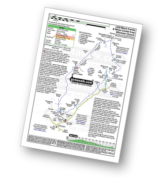
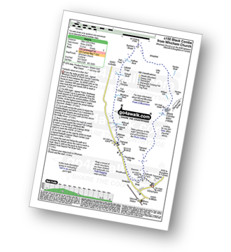
Route Summary:
Silecroft - Whicham Church - Kirkbank Farm - Townend Knotts - Black Combe - Blackcombe Screes - Whitcombe Screes - Stoupdale Head - White Combe - White Hall Knott - Whitecombe Beck - Parsonage Breast - Kirkbank Farm - Whicham Church.
|
Vital Statistics:
| Length: | 8.75 miles (14 km) |
| Ascent: | 2,307ft (703m) |
| Time: | 5½ hrs |
| Grade: | |
Route Summary:
Silecroft - Whicham Church - Kirkbank Farm - Townend Knotts - Black Combe - Blackcombe Screes - William Gill - Hentoe Hill - Butcher's Breast - Littlefell Crags - Tarn Dimples - Whitbeck Mill - Townend Hall - Whitebeck - Throstlerake Crag Fell Brow - Whicham Church - Silecroft
|
Vital Statistics:
| Length: | 9.5 miles (15 km) |
| Ascent: | 3,523ft (1,074m) |
| Time: | 7 hrs |
| Grade: | |
Route Summary:
Walna Scar Road (nr Seathwaite (Duddon Valley) - Long Houses - Brown Pike - Dow Crag - Goat's Hawse - The Old Man of Coniston - Brim Fell - Levers Hawse - Swirl Band - Swirl How - Great Carrs - Grey Friar - Seathwaite Tarn - Walna Scar Road.
|
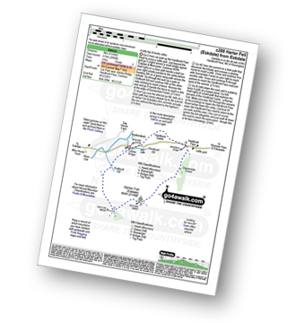
Vital Statistics:
| Length: | 4 miles (6.5 km) |
| Ascent: | 1,651ft (503m) |
| Time: | 3.25hrs |
| Grade: | |
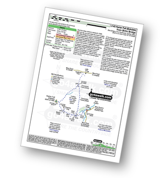
Route Summary:
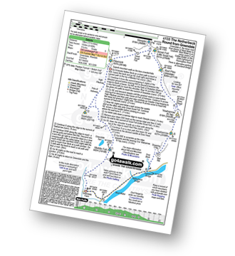
Birks Bridge - Birks Farm - Harter Fell (Eskdale) - Dunnerdale Forest - River Duddon - Birks Bridge
|
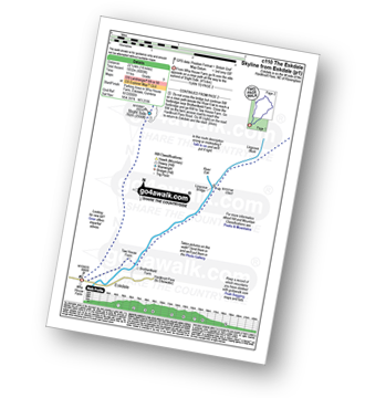
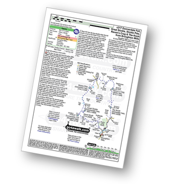
Vital Statistics:
| Length: | 11 miles (17.5 km) |
| Ascent: | 5,409ft (1,648m) |
| Time: | 9½ hrs |
| Grade: | |
Route Summary:
Wasdale Head - (National Trust Campsite) - Wast Water - Lingmell - Corridor Route - Great End - Ill Crag - Broad Crag - Scafell Pike - Mickledore - Foxes Tarn - Symonds Knott - Sca Fell - Slight Side - Broad Tongue - Hardrigg Gill - Wasdale Head - Wast Water.
|
Vital Statistics:
| Length: | 7.5 miles (12 km) |
| Ascent: | 4,195ft (1,279m) |
| Time: | 7 hrs |
| Grade: | |
Route Summary:
Wasdale Head - (National Trust Campsite) - Wast Water - Lingmell - Corridor Route - Scafell Pike - Mickledore - Foxes Tarn - Symonds Knott - Sca Fell - Lingmell Gill - Wasdale Head - Wast Water.
|
Vital Statistics:
| Length: | 15.25 miles (24.5 km) |
| Ascent: | 4,841ft (1,475m) |
| Time: | 10½ hrs |
| Grade: | |
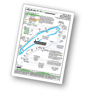
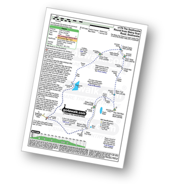
Route Summary:
Wasdale Head - (National Trust Campsite) - Wast Water - Lingmell Gill - Illgill Head - Whin Rigg - Greathall Gill - Low Wood - Lund Bridge - Woodhow Farm - Woodhow Tarn - Scale Farm - Tosh Tarn - Gill Farm - Gill Beck - Buckbarrow - Cold Well - Nether Wasdale Common - Seatallan - Windscale Hows - Middle Fell (Wasdale) - Greendale Farm - Nether Beck - Overbeck Bridge - Wasdale Head - Wast Water.
|
Vital Statistics:
| Length: | 9 miles (14.5 km) |
| Ascent: | 2,402ft (732m) |
| Time: | 5.75hrs |
| Grade: | |
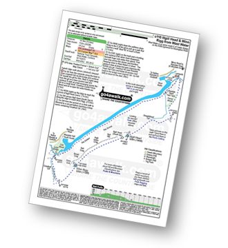
Route Summary:
Wasdale Head - (National Trust Campsite) - Wast Water - Lingmell Gill - Illgill Head - Whin Rigg - Greathall Gill - Wasdale Hall Youth Hostel - Wast Water - Wasdale Head
|
Vital Statistics:
| Length: | 9.75 miles (15.5 km) |
| Ascent: | 5,140ft (1,567m) |
| Time: | 8.75hrs |
| Grade: | |
Route Summary:
Wasdale Head - (National Trust Campsite) - Wast Water - Lingmell - Middleboot Knotts - Round How (Scafell) - Great End - Ill Crag - Broad Crag - Scafell Pike - Mickledore - Foxes Tarn - Symonds Knott - Sca Fell - Wast Water.
Not familiar with the area around CA18?
See these 30 nearest walks to UK Postcode CA18 on a google map


