The North West region of England - a fully detailed list of all the Mountains, Peaks, Tops and Hills (Page of 16)
The North West region of England comprises the traditional counties of Cheshire, Cumbria, Greater Manchester, Lancashire and Mersyside and includes The Lake District National Park, The Forest of Bowland, parts of The Yorkshire Dales National Park and parts of the Peak District National Park.
If you include all the Mountains (Hewitts), the Deweys, the Nuttalls, the Marilyns, the Bridgets (Hills) and all the Mountains, Tops, Peaks and Hills with a Trig Point on them there are 464 tops to climb, bag & conquer and the highest point is Scafell Pike at 978m (3,210ft).
To see these Mountains, Peaks, Tops and Hills displayed in different ways - see the options in the left-hand column and towards the bottom of this page.
![]() Your Personal Bagging Record for North West of
Your Personal Bagging Record for North West of
LOG ON and RELOAD this page to show which Mountains, Peaks, Tops and Hills you have already climbed, bagged & conquered [. . . more details]
See this list in: Alphabetical Order
| Height Order‡
To reverse the order select the link again.
Mountain, Peak, Top or Hill:
Bagged

![]()
1. Humphrey Head
53m (173ft)
Humphrey Head is on interactive maps:
A downloadable go4awalk.com PDF Peak Bagging Map featuring Humphrey Head will be available soon. |

![]()
2. Helsby Hill
141m (462ft)
Helsby Hill is on interactive maps:
Helsby Hill is on downloadable PDF you can Print or Save to your Phone: |

![]()
3. Arnside Knott
159m (522ft)
Arnside Knott is on interactive maps:
Arnside Knott is on downloadable PDF you can Print or Save to your Phone: |
![]()
4. Warton Crag
163m (534ft)
Warton Crag is on interactive maps:
|

![]()
5. Oaken Head
163m (535ft)
Oaken Head is on interactive maps:
|
![]()
6. Hangingstone Hill (Eddisbury Hill)
176m (577ft)
Hangingstone Hill (Eddisbury Hill) is on interactive maps:
Hangingstone Hill (Eddisbury Hill) is on downloadable PDF you can Print or Save to your Phone: |
![]()
7. High Billinge
178m (584ft)
High Billinge is on interactive maps:
|
![]()
8. Billinge Hill
179m (587ft)
Billinge Hill is on interactive maps:
Billinge Hill is on downloadable PDF you can Print or Save to your Phone: |
![]()
9. Lowsacles Hill
189m (620ft)
Lowsacles Hill is on interactive maps:
|
![]()
10. Brant Fell
191m (626ft)
Brant Fell is on interactive maps:
A downloadable go4awalk.com PDF Peak Bagging Map featuring Brant Fell will be available soon. |
![]()
11. Grassgarth Heights
205m (672ft)
Grassgarth Heights is on interactive maps:
|

![]()
12. Lord's Seat (Whitbarrow Scar)
215m (706ft)
Lord's Seat (Whitbarrow Scar) is on interactive maps:
A downloadable go4awalk.com PDF Peak Bagging Map featuring Lord's Seat (Whitbarrow Scar) will be available soon. |
![]()
13. Hampsfell
221m (725ft)
Hampsfell is on interactive maps:
A downloadable go4awalk.com PDF Peak Bagging Map featuring Hampsfell will be available soon. |
![]()
14. Raw Head (Rawhead)
227m (745ft)
Raw Head (Rawhead) is on interactive maps:
Raw Head (Rawhead) is on downloadable PDF you can Print or Save to your Phone: |
![]()
15. Muncaster Fell (Hooker Crag)
231m (758ft)
Muncaster Fell (Hooker Crag) is on interactive maps:
A downloadable go4awalk.com PDF Peak Bagging Map featuring Muncaster Fell (Hooker Crag) will be available soon. |
![]()
16. Scout Scar (Barrowfield)
233m (765ft)
Scout Scar (Barrowfield) is on interactive maps:
A downloadable go4awalk.com PDF Peak Bagging Map featuring Scout Scar (Barrowfield) will be available soon. |
![]()
17. Saskills (Newton Fell)
235m (771ft)
Saskills (Newton Fell) is on interactive maps:
A downloadable go4awalk.com PDF Peak Bagging Map featuring Saskills (Newton Fell) will be available soon. |
![]()
18. Blaze Fell
242m (794ft)
Blaze Fell is on interactive maps:
Blaze Fell is on downloadable PDF you can Print or Save to your Phone: |
![]()
19. Swinside (Portinscale)
244m (800ft)
Swinside (Portinscale) is on interactive maps:
Swinside (Portinscale) is on downloadable PDF you can Print or Save to your Phone: *Version including the walk routes marked on it that you need to follow to Walk all 214 Wainwrights in just 59 walks. |
![]()
20. High Park
247m (810ft)
High Park is on interactive maps:
|
![]()
21. Quarrystone Bank (Whinfell Forest)
254m (833ft)
Send it in and we'll publish it here.
Quarrystone Bank (Whinfell Forest) is on interactive maps:
Quarrystone Bank (Whinfell Forest) is on downloadable PDF you can Print or Save to your Phone: |
![]()
22. Setmurthy Common (Watch Hill)
254m (833ft)
Setmurthy Common (Watch Hill) is on interactive maps:
Setmurthy Common (Watch Hill) is on downloadable PDF you can Print or Save to your Phone: *Version including the walk routes marked on it that you need to follow to Walk all 214 Wainwrights in just 59 walks. |
![]()
23. Crook Knott
256m (840ft)
Crook Knott is on interactive maps:
|
![]()
24. Beacon Fell (Forest of Bowland)
266m (873ft)
Beacon Fell (Forest of Bowland) is on interactive maps:
Beacon Fell (Forest of Bowland) is on downloadable PDF you can Print or Save to your Phone: |
![]()
25. Maiden Castle
266m (873ft)
Maiden Castle is on interactive maps:
Maiden Castle is on downloadable PDF you can Print or Save to your Phone: *Version including the walk routes marked on it that you need to follow to Walk all 214 Wainwrights in just 59 walks. |
![]()
26. Black Brows
268m (879ft)
Black Brows is on interactive maps:
|
![]()
27. Claife Heights (High Blind How)
270m (886ft)
Claife Heights (High Blind How) is on interactive maps:
A downloadable go4awalk.com PDF Peak Bagging Map featuring Claife Heights (High Blind How) will be available soon. |
![]()
28. Hutton Roof Crags
274m (899ft)
Hutton Roof Crags is on interactive maps:
Hutton Roof Crags is on downloadable PDF you can Print or Save to your Phone: |
![]()
29. Dow Bank
280m (919ft)
Dow Bank is on interactive maps:
Dow Bank is on downloadable PDF you can Print or Save to your Phone: *Version including the walk routes marked on it that you need to follow to Walk all 214 Wainwrights in just 59 walks. |
![]()
30. Scout Hill
285m (935ft)
Scout Hill is on interactive maps:
|
View these 464 Mountains, Peaks, Tops and Hills:
- On an Interactive Google Map with a list of tops below it.
(makes it easier to locate a particular top) - On a Detailed List in:
Alphabetical Order | Height Order - On one page with 'yet-to-be-bagged' listed 1st
& then 'already-bagged' tops listed 2nd in:
Alphabetical Order | Height Order - On one page with 'already-bagged' tops listed 1st
& then 'yet-to-be-bagged' tops listed 2nd in:
Alphabetical Order | Height Order
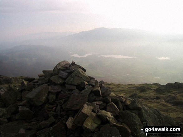
 The view from Scafell Pike in The Central Fells area of The Lake District
Photo: David Cochrane
Is there a Mountain, Peak, Top or Hill missing from the above google map or list?
Let us know an we will add it to our database.

To contribute to go4awalk.com or to contact us about anything at all - see Talk To Us.
For help see Help.
go4awalk.com and go4awalk.co.uk are registered trademarks of TMDH Limited.
Copyright © 2000-2026 TMDH Limited. All rights reserved.
Copyright Terms & Conditions Privacy Statement
A - Z Walks Home Log On/Accounts Photo Gallery Walk Ideas and Collections Fell Facts Hill Skills Walking Questions and Answers Your Stories News Competitions Product Reviews/Gear Tests Walking Gear Guides Peaks and Mountains Peak Bagging Find New Walking Friends Camping GPS Waypoints for Walking Contents Walk Search Talk To Us go4awalk.com Help Free Example Walks Newsletter


