The Heart of England region of England - a fully detailed list of all the Mountains, Peaks, Tops and Hills
The Heart of England region of England comprises the traditional counties of Bedfordshire, Berkshire, Buckinghamshire, Gloucestershire, Greater London, Hertfordshire, Northamptonshire, Oxfordshire and Wiltshire.
If you include the Marilyns, the Bridgets (Hills) and all the Mountains, Tops, Peaks and Hills with a Trig Point on them there are 39 tops to climb, bag & conquer and the highest point is Cleeve Hill at 330m (1,083ft).
To see these Mountains, Peaks, Tops and Hills displayed in different ways - see the options in the left-hand column and towards the bottom of this page.
LOG ON and RELOAD this page to show which Mountains, Peaks, Tops and Hills you have already climbed, bagged & conquered [. . . more details]
See this list in: Alphabetical Order
| Height Order‡
To reverse the order select the link again.
Mountain, Peak, Top or Hill:
Bagged
1. Brandon Hill (Cabot Tower)
70m (229ft)
Bridget
We hope to have walks that climb & bag Brandon Hill (Cabot Tower) very soon
See the location of Brandon Hill (Cabot Tower) and walks up it on a google MapBrandon Hill (Cabot Tower) is on interactive maps:
OS Explorer (Orange Covers): 154 or
155
OS Landranger (Pink Covers): 172 or
182
|
2. Ashley Hill
145m (475ft)
Bridget
OS Trig Point
We hope to have walks that climb & bag Ashley Hill very soon
See the location of Ashley Hill and walks up it on a google MapAshley Hill is on interactive maps:
OS Explorer (Orange Covers): 172
OS Landranger (Pink Covers): 175
|
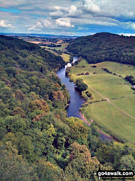
3. Symonds Yat Rock
153m (502ft)
Bridget
To walk, climb & bag Symonds Yat Rock use any of these easy-to-follow walks:
See the location of Symonds Yat Rock and walks up it on a google MapSymonds Yat Rock is on interactive maps:
OS Explorer (Orange Covers): OL14
OS Landranger (Pink Covers): 162
|
4. Chosen Hill (Churchdown Hill)
154m (505ft)
Bridget
OS Trig Point
We hope to have walks that climb & bag Chosen Hill (Churchdown Hill) very soon
See the location of Chosen Hill (Churchdown Hill) and walks up it on a google MapChosen Hill (Churchdown Hill) is on interactive maps:
OS Explorer (Orange Covers): 179
OS Landranger (Pink Covers): 162
|
5. Badbury Hill
158m (519ft)
Bridget
OS Trig Point
To walk, climb & bag Badbury Hill use this easy-to-follow walk:
See the location of Badbury Hill and walks up it on a google MapBadbury Hill is on interactive maps:
OS Explorer (Orange Covers): 170
OS Landranger (Pink Covers): 163
|
6. Maes Knoll (North East Slope)
160m (525ft)
Bridget
The north-eastern slope of Maes Knoll is the highest point in the county of Bristol
We hope to have walks that climb & bag Maes Knoll (North East Slope) very soon
See the location of Maes Knoll (North East Slope) and walks up it on a google MapMaes Knoll (North East Slope) is on interactive maps:
OS Explorer (Orange Covers): 154 and
155
OS Landranger (Pink Covers): 172 and
182
|
7. Shotover Hill
171m (561ft)
Bridget
We hope to have walks that climb & bag Shotover Hill very soon
See the location of Shotover Hill and walks up it on a google MapShotover Hill is on interactive maps:
OS Explorer (Orange Covers): 180
OS Landranger (Pink Covers): 164
|
8. Inotts Clump
175m (574ft)
Bridget
OS Trig Point
To walk, climb & bag Inotts Clump use this easy-to-follow walk:
See the location of Inotts Clump and walks up it on a google MapInotts Clump is on interactive maps:
OS Explorer (Orange Covers): 191
OS Landranger (Pink Covers): 164
|
9. Muswell Hill
198m (649ft)
Bridget
OS Trig Point
To walk, climb & bag Muswell Hill use this easy-to-follow walk:
See the location of Muswell Hill and walks up it on a google MapMuswell Hill is on interactive maps:
OS Explorer (Orange Covers): 165
180
OS Landranger (Pink Covers): 164
|
10. Robins Wood Hill
198m (649ft)
Bridget
OS Trig Point
We hope to have walks that climb & bag Robins Wood Hill very soon
See the location of Robins Wood Hill and walks up it on a google MapRobins Wood Hill is on interactive maps:
OS Explorer (Orange Covers): 179
OS Landranger (Pink Covers): 162
|
11. Downham Hill (Smallpox Hill)
199m (653ft)
Bridget
Downham Hill is also known locally as 'Smallpox Hill' because it was also once the site of an isolation hospital, the remains of which can still be seen.
To walk, climb & bag Downham Hill (Smallpox Hill) use this easy-to-follow walk:
See the location of Downham Hill (Smallpox Hill) and walks up it on a google MapDownham Hill (Smallpox Hill) is on interactive maps:
OS Explorer (Orange Covers): 167
OS Landranger (Pink Covers): 162
|
12. Alderton Hill
203m (666ft)
Bridget
We hope to have walks that climb & bag Alderton Hill very soon
See the location of Alderton Hill and walks up it on a google MapAlderton Hill is on interactive maps:
OS Explorer (Orange Covers): OL45
OS Landranger (Pink Covers): 150
A downloadable go4awalk.com PDF Peak Bagging Map featuring Alderton Hill will be available soon. |
13. White Horse Hill
205m (672ft)
Bridget
OS Trig Point
White Horse Hill is the highest point in the county of Oxfordshire.
We hope to have walks that climb & bag White Horse Hill very soon
See the location of White Horse Hill and walks up it on a google MapWhite Horse Hill is on interactive maps:
OS Explorer (Orange Covers): OL15
OS Landranger (Pink Covers): 194
A downloadable go4awalk.com PDF Peak Bagging Map featuring White Horse Hill will be available soon. |
14. Cold Ashby
210m (689ft)
Bridget
OS Trig Point
In April 1936, Cold Ashby was the location of the very first Ordnance Survey Trig Point.
We hope to have walks that climb & bag Cold Ashby very soon
See the location of Cold Ashby and walks up it on a google MapCold Ashby is on interactive maps:
OS Explorer (Orange Covers): 233
OS Landranger (Pink Covers): 140
|
15. Cam Long Down
220m (722ft)
Bridget
To walk, climb & bag Cam Long Down use this easy-to-follow walk:
See the location of Cam Long Down and walks up it on a google MapCam Long Down is on interactive maps:
OS Explorer (Orange Covers): 167
OS Landranger (Pink Covers): 162
|
16. Oxenton Hill
223m (731ft)
Bridget
OS Trig Point
We hope to have walks that climb & bag Oxenton Hill very soon
See the location of Oxenton Hill and walks up it on a google MapOxenton Hill is on interactive maps:
OS Explorer (Orange Covers): 190
OS Landranger (Pink Covers): 150
|
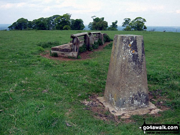
17. Arbury Hill
225m (738ft)
Bridget
Arbury Hill is the highest point in the county of Northamptonshire. The summit itself is on private land.
To walk, climb & bag Arbury Hill use this easy-to-follow walk:
See the location of Arbury Hill and walks up it on a google MapArbury Hill is on interactive maps:
OS Explorer (Orange Covers): 206
OS Landranger (Pink Covers): 152
|
18. Dunstable Down
244m (800ft)
Bridget
OS Trig Point
Dunstable Down is the highest point in the county of Bedfordshire.
We hope to have walks that climb & bag Dunstable Down very soon
See the location of Dunstable Down and walks up it on a google MapDunstable Down is on interactive maps:
OS Explorer (Orange Covers): 181 and
182
OS Landranger (Pink Covers): 166
A downloadable go4awalk.com PDF Peak Bagging Map featuring Dunstable Down will be available soon. |
19. Pavis Wood
244m (800ft)
Bridget
We hope to have walks that climb & bag Pavis Wood very soon
See the location of Pavis Wood and walks up it on a google MapPavis Wood is on interactive maps:
OS Explorer (Orange Covers): 181
OS Landranger (Pink Covers): 165
|
20. South Hill
248m (813ft)
Bridget
We hope to have walks that climb & bag South Hill very soon
See the location of South Hill and walks up it on a google MapSouth Hill is on interactive maps:
OS Explorer (Orange Covers): OL45
191
OS Landranger (Pink Covers): 151
|
21. Clipper Down (Crawley Wood)
249m (817ft)
Bridget
OS Trig Point
We hope to have walks that climb & bag Clipper Down (Crawley Wood) very soon
See the location of Clipper Down (Crawley Wood) and walks up it on a google MapClipper Down (Crawley Wood) is on interactive maps:
OS Explorer (Orange Covers): 181
OS Landranger (Pink Covers): 165
|
22. Cowleaze Wood (Bald Hill)
257m (843ft)
Bridget
We hope to have walks that climb & bag Cowleaze Wood (Bald Hill) very soon
See the location of Cowleaze Wood (Bald Hill) and walks up it on a google MapCowleaze Wood (Bald Hill) is on interactive maps:
OS Explorer (Orange Covers): 171
OS Landranger (Pink Covers): 165
|
23. Ilmington Down (Ebrington Hill)
259m (850ft)
Bridget
OS Trig Point
We hope to have walks that climb & bag Ilmington Down (Ebrington Hill) very soon
See the location of Ilmington Down (Ebrington Hill) and walks up it on a google MapIlmington Down (Ebrington Hill) is on interactive maps:
OS Explorer (Orange Covers): 205
OS Landranger (Pink Covers): 151
|
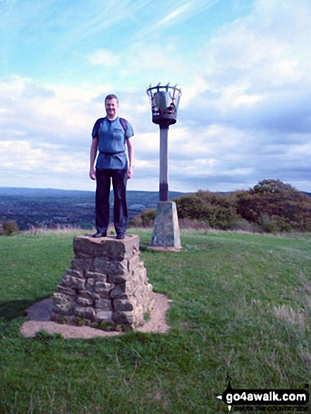
24. Monument Hill (Coombe Hill)
260m (853ft)
Bridget
OS Trig Point
To walk, climb & bag Monument Hill (Coombe Hill) use this easy-to-follow walk:
See the location of Monument Hill (Coombe Hill) and walks up it on a google MapMonument Hill (Coombe Hill) is on interactive maps:
OS Explorer (Orange Covers): 181
OS Landranger (Pink Covers): 165
|
25. Wendover Woods (Haddington Hill)
267m (876ft)
Marilyn (149th in England, 1437th in GB)
OS Trig Point
Wendover Woods (Haddington Hill) is the highest point in the county of Buckinghamshire.
We hope to have walks that climb & bag Wendover Woods (Haddington Hill) very soon
See the location of Wendover Woods (Haddington Hill) and walks up it on a google MapWendover Woods (Haddington Hill) is on interactive maps:
OS Explorer (Orange Covers): 181
OS Landranger (Pink Covers): 165
|
26. Hackpen Hill (Winterbourne Down)
272m (892ft)
Bridget
OS Trig Point
We hope to have walks that climb & bag Hackpen Hill (Winterbourne Down) very soon
See the location of Hackpen Hill (Winterbourne Down) and walks up it on a google MapHackpen Hill (Winterbourne Down) is on interactive maps:
OS Explorer (Orange Covers): 157
OS Landranger (Pink Covers): 173
|
27. Langley Hill
274m (899ft)
Bridget
OS Trig Point
We hope to have walks that climb & bag Langley Hill very soon
See the location of Langley Hill and walks up it on a google MapLangley Hill is on interactive maps:
OS Explorer (Orange Covers): OL45
OS Landranger (Pink Covers): 150
163
|
28. Liddington Castle (Liddington Hill)
276m (905ft)
Bridget
OS Trig Point
We hope to have walks that climb & bag Liddington Castle (Liddington Hill) very soon
See the location of Liddington Castle (Liddington Hill) and walks up it on a google MapLiddington Castle (Liddington Hill) is on interactive maps:
OS Explorer (Orange Covers): 157
OS Landranger (Pink Covers): 174
|
29. Win Green
277m (909ft)
Marilyn (142nd in England, 1422nd in GB)
OS Trig Point
We hope to have walks that climb & bag Win Green very soon
See the location of Win Green and walks up it on a google MapWin Green is on interactive maps:
OS Explorer (Orange Covers): 118
OS Landranger (Pink Covers): 184
|
30. Buck Stone
279m (915ft)
Bridget
OS Trig Point
We hope to have walks that climb & bag Buck Stone very soon
See the location of Buck Stone and walks up it on a google MapBuck Stone is on interactive maps:
OS Explorer (Orange Covers): OL14
OS Landranger (Pink Covers): 162
|
31. Buckstone
279m (915ft)
Bridget
OS Trig Point
We hope to have walks that climb & bag Buckstone very soon
See the location of Buckstone and walks up it on a google MapBuckstone is on interactive maps:
OS Explorer (Orange Covers): OL14
OS Landranger (Pink Covers): 162
A downloadable go4awalk.com PDF Peak Bagging Map featuring Buckstone will be available soon. |
32. Long Knoll
288m (945ft)
Marilyn (138th in England, 1400th in GB)
OS Trig Point
We hope to have walks that climb & bag Long Knoll very soon
See the location of Long Knoll and walks up it on a google MapLong Knoll is on interactive maps:
OS Explorer (Orange Covers): 142
OS Landranger (Pink Covers): 183
A downloadable go4awalk.com PDF Peak Bagging Map featuring Long Knoll will be available soon. |
33. Ruardean Hill
290m (951ft)
Marilyn (137th in England, 1396th in GB)
OS Trig Point
We hope to have walks that climb & bag Ruardean Hill very soon
See the location of Ruardean Hill and walks up it on a google MapRuardean Hill is on interactive maps:
OS Explorer (Orange Covers): OL14
OS Landranger (Pink Covers): 162
A downloadable go4awalk.com PDF Peak Bagging Map featuring Ruardean Hill will be available soon. |
34. Milk Hill
295m (968ft)
Bridget
Milk Hill is the highest point in the county of Wiltshire.
Milk Hill was promoted to Marilyn status in 1997 but demoted again in 1999.
We hope to have walks that climb & bag Milk Hill very soon
See the location of Milk Hill and walks up it on a google MapMilk Hill is on interactive maps:
OS Explorer (Orange Covers): 157
OS Landranger (Pink Covers): 173
|
35. May Hill
296m (971ft)
Marilyn (134th in England, 1384th in GB)
OS Trig Point
We hope to have walks that climb & bag May Hill very soon
See the location of May Hill and walks up it on a google MapMay Hill is on interactive maps:
OS Explorer (Orange Covers): OL14
OS Landranger (Pink Covers): 162
|
36. Walbury Hill
297m (974ft)
Marilyn (133rd in England, 1382nd in GB)
OS Trig Point
Walbury Hill is the highest point in the county Berkshire.
We hope to have walks that climb & bag Walbury Hill very soon
See the location of Walbury Hill and walks up it on a google MapWalbury Hill is on interactive maps:
OS Explorer (Orange Covers): 158
OS Landranger (Pink Covers): 174
|
37. Birdlip Hill
299m (981ft)
Bridget
OS Trig Point
We hope to have walks that climb & bag Birdlip Hill very soon
See the location of Birdlip Hill and walks up it on a google MapBirdlip Hill is on interactive maps:
OS Explorer (Orange Covers): 179
OS Landranger (Pink Covers): 163
|
38. Seven Wells Hill
319m (1,046ft)
Bridget
We hope to have walks that climb & bag Seven Wells Hill very soon
See the location of Seven Wells Hill and walks up it on a google MapSeven Wells Hill is on interactive maps:
OS Explorer (Orange Covers): OL45
OS Landranger (Pink Covers): 150
|
39. Cleeve Hill
330m (1,083ft)
Marilyn (117th in England, 1329th in GB)
OS Trig Point
Cleeve Hill is the highest point in the county of Gloucestershire.
We hope to have walks that climb & bag Cleeve Hill very soon
See the location of Cleeve Hill and walks up it on a google MapCleeve Hill is on interactive maps:
OS Explorer (Orange Covers): 179
OS Landranger (Pink Covers): 163
|
View these 39 Mountains, Peaks, Tops and Hills:
Is there a Mountain, Peak, Top or Hill missing from the above google map or list?
Let us know an we will add it to our database.